Many times, our gaze is directed towards the heavens as we contemplate the wonders of outer space. We immerse ourselves in books about astronauts and satellites, believing that all the enigmas that elude humanity are found beyond our planet. However, we often overlook the fact that our own Earth is teeming with astonishing mysteries. We fantasize about the cosmos without fully appreciating the intricate and fascinating composition of our home.
The composition of the Earth’s interior
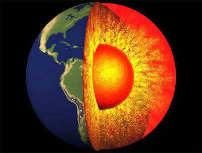
The Earth is composed of three distinct layers: the crust, the mantle, and the core. To visualize this, we can think of the Earth as being similar to an egg. In this analogy, the Earth’s crust can be likened to the shell of the egg, while the mantle is equivalent to the egg white, and the core represents the yolk.
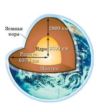
The lithosphere, also known as the upper part of the Earth, consists of the Earth’s crust and the upper section of the mantle. It forms a solid shell around the globe.
This textbook is specifically designed for students in Grade 6 and is a component of the Classical Geography textbook series. With its contemporary layout, diverse range of questions and tasks, and the option for simultaneous use with the digital version of the textbook, it facilitates the efficient acquisition of educational content. Moreover, this textbook aligns with the Federal State Educational Standard of Basic General Education.
Crust of the Earth
The Earth’s crust is a solid outer layer that encompasses the entire surface of our planet. It is approximately 15 kilometers thick beneath the oceans and 75 kilometers thick beneath the continents. To put it in perspective, the Earth’s crust is thinner than an eggshell in relation to the entire planet. This layer makes up only 5% of the volume and less than 1% of the mass of the Earth.
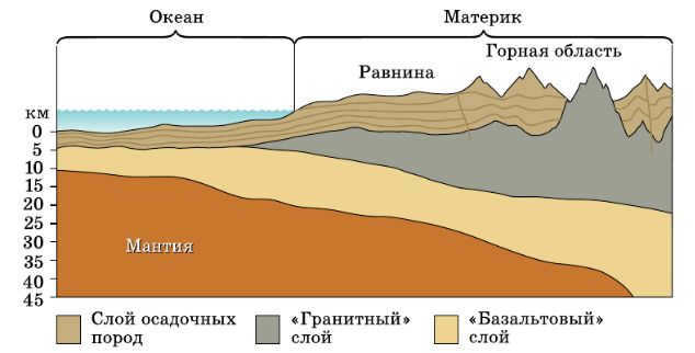
In the Earth’s crust, scientists have discovered oxides of silicon, alkali metals, aluminum, and iron. The crust beneath the oceans is composed of sedimentary and basalt layers and is denser than the continental crust. Meanwhile, the crust covering the continents has a more intricate composition.
The continental crust can be divided into three layers:
- The Earth’s crust is composed of different types of rocks, including sedimentary rocks, which make up about 10-15 km of the crust. These rocks are formed from the accumulation and consolidation of sediments over time.
- Another type of rock found in the Earth’s crust is granitic rock, which makes up about 5-15 km of the crust. These rocks have properties similar to granite, a common type of rock that is often used in construction and sculpture.
- The third type of rock found in the Earth’s crust is basaltic rock, which makes up about 10-35 km of the crust. These rocks are formed from molten lava that cools and solidifies, creating a dense, fine-grained rock.
Mantle
The Mantle is a layer of the Earth’s interior that lies between the crust and the core. It is mainly composed of solid rock and extends to a depth of about 2,900 kilometers. The mantle is divided into two regions: the upper mantle and the lower mantle. The upper mantle is more solid and rigid, while the lower mantle is more fluid-like. This division is based on differences in temperature and pressure. The mantle plays a crucial role in the movement of tectonic plates and the convection of heat within the Earth. It is also the source of magma that erupts from volcanoes. Overall, the mantle is a dynamic and important part of our planet’s structure.
Below the Earth’s crust lies the mantle, which can be described as a “blanket” or “cloak”. This layer is incredibly thick, measuring up to 2900 km. It makes up approximately 83% of the planet’s total volume and nearly 70% of its mass. The mantle is composed of dense minerals that are rich in iron and magnesium. Despite the extremely high temperature of over 2000°C, the majority of the mantle remains in a solid crystalline state due to the immense pressure. At a depth ranging from 50 to 200 km, there exists a mobile upper layer within the mantle known as the asthenosphere, meaning “powerless sphere”. The asthenosphere is highly malleable, and its plasticity is responsible for volcanic eruptions and the formation of mineral deposits. Its thickness can range from 100 to 250 km. The material that originates from the asthenosphere and occasionally rises to the Earth’s crust is referred to as magma, which can be likened to a “mash” or “thick ointment”. When magma cools and solidifies on the Earth’s surface, it transforms into lava.
The central part
Deep beneath the Earth’s surface, lies the core, resembling a protective blanket. Situated approximately 2900 kilometers from the planet’s outer shell, the core takes the form of a spherical shape with a radius measuring around 3500 km. Due to the inaccessibility of the core, scientists can only speculate about its composition. It is believed that the core is primarily composed of iron, accompanied by traces of other elements. This section of the planet is incredibly dense and holds immense weight, constituting a mere 15% of the Earth’s overall volume yet accounting for a substantial 35% of its total mass.
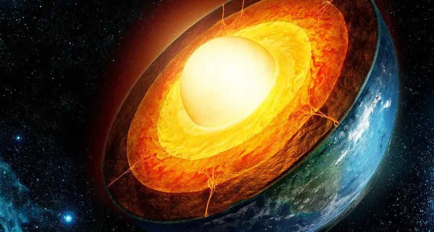
There is a belief that the core of the Earth is composed of two layers – a solid inner core with a radius of approximately 1300 km and a liquid outer core with a radius of about 2200 km. The inner core appears to be floating within the outer liquid layer. This smooth motion generates the planet’s magnetic field, which serves as a shield against harmful cosmic rays and influences the direction of a compass needle. The core is the hottest region on our planet. It was previously believed that its temperature reached an estimated 4000-5000°C. However, in 2013, scientists conducted a laboratory experiment to determine the melting point of iron, which is likely present in the Earth’s inner core. The results revealed that the temperature between the solid inner core and the liquid outer core is equivalent to the surface temperature of the Sun, approximately 6000°C.
The arrangement of our planet remains an enigmatic puzzle for humanity. The majority of knowledge about it is acquired through indirect means, and no scientist has yet succeeded in procuring samples of the Earth’s innermost core. The exploration of the Earth’s structure and composition continues to encounter formidable challenges, yet researchers persist in their quest, seeking novel avenues to acquire dependable insights into our planet.
When learning about the “Internal Structure of the Earth”, students may encounter difficulties in memorizing the names and sequence of the planet’s layers. It would be much easier for students to remember the Latin names if they create their own Earth model. Students can be encouraged to make a plasticine globe model or discuss its structure using examples from fruits (such as the Earth’s crust being likened to the peel, the mantle to the pulp, and the core to the bone) and other objects with similar structures. You can refer to the Geography textbook for grades 5-6 by O.A. Klimanova, which contains vivid illustrations and detailed information on this topic.
The heart of our planet, known as the Earth’s core, is a mysterious and enigmatic place. It is situated at the center and is the deepest part of our planet. One of the most fascinating aspects of the core is its extreme temperature, reaching a scorching 6000 °C, which is comparable to the searing heat of the Sun’s surface. The question that arises is, what causes the core to possess such an incredibly high temperature, and is there a possibility that it could cool down in the future? Today, we embark on a journey to uncover the answers to these intriguing questions. Let us begin.
The Core of the Planet Earth
The core of the Earth is a highly heated sphere composed mainly of iron (85%), nickel (10%), and other unidentified elements (5%). Its radius measures around 1300 kilometers. The presence of a magnetic field in our planet indicates the existence of two layers in the core, with a significant amount of iron. The mantle, located below the Earth’s crust but above the core, is too weak to conduct electricity and generate such a field. According to the geodynamo model, which aims to explain the planet’s magnetic field, only a conducting liquid can achieve this. Therefore, it can be deduced that one layer of the core is in a liquid state. Additionally, scientists studying surface oscillations (S-waves) have observed an intriguing phenomenon: these waves do not appear on the opposite side of the planet but vanish. Elastic S-waves can only pass through solid materials, not liquids. This led scientists to conclude that the Earth’s interior contains a liquid layer in the core. Further research revealed that this liquid layer begins at a depth of approximately 3000 kilometers. In 1930, a new type of wave, called P-waves, was discovered. These waves are twice as fast as S-waves and can penetrate through any material. As P-waves pass through the core, they slightly decelerate in its inner part, supporting the theory of a two-layered core: liquid and solid. The solid core is situated at a depth of around 6000 kilometers. This theory was confirmed about 40 years after the discovery of P-waves when scientists had access to more advanced equipment.
The core of the Earth is famous for its exceptionally high temperature, and there exist explanations for this phenomenon.
- The Earth’s core retains heat from its formation approximately 4.5 billion years ago. It is commonly understood that the core is gradually cooling over time, although this cooling process is relatively slow, with the planet cooling by approximately 100 °C every billion years.
- The core undergoes rotation, generating additional heat through friction.
- The core’s high temperature is a result of continuous heating caused by the decay of radioactive elements in its central regions.
The initial heat, naturally, gradually dissipates, but the friction between the layers and the decay of radioactive elements release heat once again, sustaining the temperature of the Earth’s core. Of course, there is a lot of discussion among scientists regarding this matter, but regrettably, there is still no consensus. If it is later discovered that the majority of the heat in the core is primary, it will require over a billion years for it to cool down. Conversely, if it is confirmed that the heat is generated by the mechanisms described above, it will take more than ten billion years for it to cool down.
Measuring the temperature of the Earth’s core is a complex task that cannot be easily accomplished using traditional methods. Extensive research and experiments are required to obtain accurate data. In 2013, French scientists conducted a groundbreaking experiment to determine the core’s temperature. They placed pure iron under extreme pressure conditions similar to those found in the Earth’s core. The experiment revealed that the temperature inside the core is approximately 5300 °C. It is worth noting that the melting point of iron is around 1540 °C, but within the core, the melting temperature is estimated to be around 6000 °C. This substantial difference can be attributed to the immense pressure exerted on the iron within the core.
Summary
The Earth’s core, which is the hottest part of the planet, continues to intrigue scientists with its mysteries and puzzles. While the core does cool over time, its complete cooling process remains unseen by human eyes. Even the Sun, which will die before the core cools completely, cannot provide us with a glimpse of this phenomenon. This concludes our discussion on the Earth’s core. We appreciate your attention.
How far is it to the center of the Earth?
The Earth, which is located at an average distance of 149,597,890 kilometers from the Sun, stands out as the third planet and one of the most exceptional celestial bodies in our solar system. Approximately 4.5-4.6 billion years ago, this planet took shape and remains the only known habitat for various forms of life. The reasons behind this phenomenon are multiple, including the composition of the atmosphere and physical characteristics such as the existence of water, which covers around 70.8% of the Earth’s surface, providing an ideal environment for life to flourish.
An additional aspect that sets Earth apart is its classification as the largest terrestrial planet among Mercury, Venus, Earth, and Mars. Unlike the gas giants Jupiter, Saturn, Neptune, and Uranus, our planet primarily consists of a relatively thin layer of rock. When considering factors such as mass, density, and diameter, Earth ranks as the fifth largest celestial body in the entirety of the solar system.
Earth’s Measurements: Mass, Volume, Circumference, and Diameter
Being the largest planet in the group of terrestrial planets, Earth has an estimated mass of 5.9722±0.0006×10 24 kilograms. It also possesses the greatest volume among these planets, measuring at 1.08321×10¹² cubic kilometers.
Furthermore, our planet has the highest density compared to other terrestrial planets due to its composition of crust, mantle, and core. The Earth’s crust is the thinnest layer, while the mantle accounts for 84% of the Earth’s volume and extends 2900 kilometers below the surface. The core, which consists of a solid, dense inner core surrounded by a liquid outer core, contributes to Earth’s density.
Earth has an average density of 5.514 grams per cubic centimeter. In comparison, Mars, the smallest planet resembling Earth in the solar system, has a density that is only about 70% of Earth’s density.
Earth, also known as the largest among the Earth-group planets in terms of circumference and diameter, holds the title with an equatorial circumference of 40,075.16 kilometers. Its size is slightly reduced between the North and South Poles, measuring at 40,008 km. The Earth has a pole diameter of 12,713.5 km and an equatorial diameter of 12,756.1 km. In contrast, the solar system’s largest planet, Jupiter, boasts a diameter of 142,984 km.
The Earth’s Geometric Shape
The Earth’s shape is not a perfect sphere, but rather a flattened spheroid or ellipsoid. This is why its circumference and diameter differ. Due to the planet’s rotation and gravity, the poles are slightly flattened, creating a bulge at the equator. As a result, the Earth has a larger circumference and diameter at the equator compared to its polar regions.
The equatorial bulge of the Earth measures approximately 42.72 kilometers. This bulge is caused by the combined effects of the planet’s rotation and gravity. Gravity, in particular, plays a significant role in shaping celestial bodies like planets. It causes them to contract and take on a spherical form, as it pulls the entire mass of the object towards its center of gravity. In the case of the Earth, this center of gravity is located at its core.
As the Earth spins, it experiences a distortion due to the centrifugal force. This force is responsible for pushing objects away from the center of gravity. When the Earth rotates, the centrifugal force is strongest at the equator, resulting in a slight bulge in that region. This bulge causes the equator to have a larger circumference and diameter compared to other parts of the planet.
Although local topography does have an impact on the shape of the Earth, its influence is minimal when considering the global scale. The most significant variations in local topography worldwide are observed at Mount Everest, which stands as the highest point above sea level at 8,848 meters, and the Mariana Trench, which represents the lowest point below sea level at a depth of approximately 10,994±40 meters. However, these disparities only account for a difference of around 19 km, a relatively small measurement in relation to the size of the planet. Taking into account the equatorial bulge, the highest point on Earth and the farthest location from its center is found at the summit of the Chimborazo volcano in Ecuador, which is the tallest peak near the equator. Its elevation reaches 6,267 meters.
Geodesy, a scientific field that involves measuring the dimensions and form of the Earth using surveys and mathematical computations, is employed to accurately investigate the size and shape of our planet.
Throughout the course of history, geodesy has held great significance as ancient scientists and philosophers endeavored to determine the Earth’s shape. Aristotle is recognized as the first individual to have made an effort to calculate the Earth’s size, making him an early geodesist. This was followed by the Greek philosopher Eratosthenes, who approximated the Earth’s circumference to be 40,233 kilometers, a measurement that is only slightly larger than the currently accepted value.
To investigate the Earth and employ geodesy, scientists frequently make use of the ellipsoid, geoid, and reference ellipsoid. An ellipsoid is a theoretical mathematical framework that presents a streamlined, simplified depiction of the Earth’s exterior. It is utilized for measuring distances on the surface without considering variables like changes in elevation and land formations. Considering the true nature of the Earth’s surface, surveyors utilize a geoid, which is a model of the planet constructed using the average global sea level and thus accounts for discrepancies in height.
Data serves as the foundation of modern geodesy, serving as a benchmark for worldwide surveying. Contemporary advancements, such as satellites and global positioning systems (GPS), enable surveyors and other scientists to obtain remarkably precise measurements of the Earth’s surface. These measurements are so precise that they can capture data about the Earth’s surface with centimeter-level accuracy, offering unparalleled precision in determining the Earth’s dimensions and form.
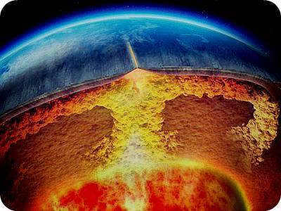
A tremendous noise echoes across the launch site in the Mohave Desert, California, USA. The earth quivers ever so slightly. However, there is no rocket to be seen in the sky. Instead, a colossal 100,000-ton mass of molten iron, heated to a scorching 1,600 degrees Celsius, is forcefully making its way towards the core of our planet. This enormous liquid metal mass was poured into a specially excavated trench measuring 300 meters in width, 300 meters in depth, and only 10 centimeters in thickness. So what is the outcome of this daring experiment? A monumental “blade” of unimaginable proportions that descends into the Earth at a staggering speed of 5 meters per second, causing miniature earthquakes. These tremors are a result of specialized devices floating within the mass of liquid iron.
What is your opinion? Does the concept seem somewhat insane? Indeed, it does… Incidentally, the individual responsible for the concept is none other than the renowned New Zealand planetologist, David Stevenson, who drew inspiration from a science fiction film centered around a voyage to the Earth’s core. Without much hesitation, Stevenson proceeded to compose a scholarly article on the matter, which was subsequently published in a highly reputable American journal, “Neuchur.”
The core of the New Zealander’s endeavor was founded on a straightforward notion: While humanity has achieved the ability to deploy scientific probes across vast cosmic expanses billions of kilometers away from our planet, we have yet to conquer the depths of our own planet beyond a mere 12 kilometers.. Isn’t that an absurd statistic? Considering that the distance from the Earth’s surface to its core is 6731 kilometers.
However, what makes the expedition to the core of the Earth so challenging? The primary obstacle lies in the tremendous amount of energy needed to drill through the planet’s layers. Furthermore, finding a fuel source that can endure the extreme pressures and high temperatures of the subsurface is no easy feat. According to scientific estimates, at a depth of 3000 kilometers, the rocks reach temperatures of 5000 degrees Celsius and experience a pressure of one million atmospheres.
It is futile to consider transporting tanks of gasoline or gas to such depths, as they would be instantly crushed and incinerated.
However, Stevenson is suggesting a method to extract energy from an easily accessible source. His proposal involves utilizing the force of Earth’s gravity. Thus, the spacecraft, referred to as “the spaceship of the bowels of the earth,” will slowly descend under its own weight. With a height of 300 meters, the “blade” will only be 10 centimeters wide. Due to the immense pressure of 100,000 tons of iron (equivalent to the daily global production), the narrow section of the ground cannot withstand it.
To accommodate the iron ship’s journey to the center of the planet, the ground will “yield.”
Naturally, the success of this endeavor hinges on the ability to conduct various scientific measurements throughout the expedition.
To achieve this goal, the blade will be equipped with metal ball probes that will roll along the walls of the rift and descend into the interior. However, the challenge lies in constructing electronic devices that can endure the immense pressure and heat. According to Stevenson, he has yet to figure out how to accomplish this.
Currently, temperature measurements at great depths are conducted in activities such as oil drilling. However, the sensors used for this purpose are encased in a robust shell and cannot withstand the pressure at depths exceeding 10 kilometers. Essentially, the development of probes for journeying to the Earth’s core must start from scratch. Nevertheless, Stevenson believes that if the same amount of funding is allocated to probe development as was spent on the Moon landing, a solution will undoubtedly be found.

Let’s imagine a situation where advanced devices are invented to measure great depths. However, the challenge lies in transmitting the gathered information to the Earth’s surface. “It’s simple,” one might say. “Just equip the devices with radio transmitters, and scientists can receive the desired data through radio waves.” Unfortunately, it’s not that straightforward. The problem is that radio waves cannot penetrate the Earth. But the innovative Stevenson has devised an alternative communication method – seismic waves, known as P waves. P waves, which are seismic waves, travel from the Earth’s depths to the surface, causing earthquakes.
To establish contact with the Earth’s surface, the balloon probe will experience shaking and trembling, resembling the familiar sound of an old alarm clock. These vibrations will travel through the layers of the Earth and eventually reach the surface. Within these vibrations, encoded information from the depths will be contained. For instance, if the temperature increases as the probe approaches the Earth’s core, the frequency of vibrations will intensify. These changes in vibrations will be meticulously recorded by highly sensitive devices known as seismographs, which are strategically placed on the surface.
Traveling at a velocity of five meters per second, it will require a total of seven days to reach the liquid core of our planet, which extends 3,000 kilometers beneath the surface.
It must be acknowledged that descending into the depths of the Earth may appear uninteresting for the leisurely traveler and adventurer. Primarily, our planet consists of solid rock in shades of gray, green, or red, depending on the predominant chemical element. There are no extraordinary caves, massive oceans, or continents submerged beneath the Earth’s surface. The extreme temperatures and immense pressures prohibit the emergence of fantastical subterranean landscapes that Jules Verne once envisioned.
However, for geoscientists, the descent of probes into the fiery depths will be an extraordinary and momentous occasion. They still have a limited understanding of the inner workings of the Earth, with only a rough estimation of the temperatures at extreme depths. In fact, the thermometer has never been able to reach below 10 kilometers.
Of particular interest to scientists will be the exploration of the boundaries between the various layers that comprise the Earth, particularly the transition between the mantle and the liquid core.
When and in what way will the journey to the center of the earth take place? Currently, only a few individuals are able to provide an answer to this question. The technical obstacles that stand in the path of the endeavor are so immense that geologists will undoubtedly need to exercise patience. However, the most optimistic among them argue: “How many individuals in 1900 would have believed that, 69 years later, humans would be walking on the moon?”
©Partial or full utilization of this article requires an active hyperlink to alfaed.ru
Imagine a scenario where we have a tunnel running through the center of the Earth. Standing at the surface of the Earth near the entrance of the tunnel, we decide to drop an object into it. The question arises: how much time will it take for the object to reach the Earth’s center? This is the type of problem that students often encounter on exams. Solving it requires a firm grasp of Newton’s laws and oscillatory equations. Specifically, one must calculate how the force of gravity (and the acceleration of free fall) changes as an object falls through a tunnel.
In the most basic scenario, the Earth can be compared to a billiard ball with a consistent density of around 5500 kg/m3. In this situation, as an object moves towards the Earth’s center, the gravitational force acting upon it also changes. This is because the amount of mass both above and below the object’s position in the tunnel differs. Newton’s theorem of zero gravity inside, named after the fact that gravity will be completely absent at the center of the planet, is applied in this case. Once the object passes through the Earth’s center, it continues to fall – this time towards the opposite side of the tunnel. Upon reaching the other end, it falls back again. Thus, it oscillates back and forth through the tunnel much like a pendulum.
Alexander Klotz accomplished a simple task – he took into account the actual variation in density throughout the planet, which differs across its various parts and layers. The Earth’s crust and mantle exhibit lower density compared to the core. Klotz derived the actual mass distribution from the Preliminary Reference Earth model, which was constructed using seismic data. This model indicates a density of less than 1000 kg/m3 near the Earth’s surface and approximately 13000 kg/m3 at the core’s center. The distance from the surface to the Earth’s center measures 6371 km. Using these parameters, Klotz determined that an object would take 38 minutes and 11 seconds to fall through a tunnel to the Earth’s center. In contrast, the fall time in a scenario where the Earth has a uniform density would be 42 minutes and 12 seconds.
The study of the internal structure of the Earth primarily relies on seismic methods that analyze the propagation of elastic waves, both longitudinal and transverse, through the Earth’s layers. These waves are generated by seismic events such as earthquakes and explosions. Based on these studies, the Earth is classified into three regions: the crust, mantle, and core. The crust, which is the outer layer, has an average thickness of approximately 35 km. There are two main types of crust: continental and oceanic. In the transition zone between continents and oceans, an intermediate type of crust is found. The thickness of the crust varies significantly, with the oceanic crust measuring about 10 km thick (including the water layer) and the continental crust being much thicker. Surface sediments form a layer around 2 km thick. Below the sediments is a granitic layer (about 20 km thick on continents) followed by a basalt layer (approximately 14 km thick in both continents and oceans), which is also known as the lower crust. The average densities are 2.6 g/cm3 at the Earth’s surface, 2.67 g/cm3 in granite, and 2.85 g/cm3 in basalt. The Earth’s mantle, also referred to as the silicate shell, extends from a depth of about 35 km to 2885 km. It is separated from the crust by a distinct boundary known as the Mohorovitch boundary, or “Moho,” where the velocities of both longitudinal and transverse seismic waves increase sharply, along with the mechanical density. In the mantle, densities increase from approximately 3.3 g/cm3 to 9.7 g/cm3 with depth. The crust and parts of the mantle consist of extensive lithospheric plates, whose movements influence the drifting of continents and the occurrence of seismic zones. Another seismic boundary, known as the Gutenberg boundary, is found between the mantle and the outer core at a depth of 2775 km. At this boundary, the speed of longitudinal waves decreases from 13.6 km/s (in the mantle) to 8.1 km/s (in the core), and the speed of transverse waves drops to zero. This indicates that the outer core is in a liquid state. It is currently believed that the outer core is composed of 12% sulfur and 88% iron. Finally, at depths above 5120 km, seismic methods have revealed the presence of a solid inner core, which accounts for 1.7% of the Earth’s mass. This inner core is likely composed of an iron-nickel alloy (80% Fe, 20% Ni).
Calculating the Distance to the Earth’s Center
To determine the exact number of kilometers to the center of the Earth, we must first understand the unique shape of our planet. The Earth is an oblate spheroid, slightly flattened at the poles. It could also be described as a geoid, although in an ideal scenario, it would be entirely liquid. The topography of the Earth also adds its own complexities. Here are a few interesting facts about the Earth’s relief:
- The highest point on the Earth’s surface is Mount Everest, which stands at a height of 8,848 meters above sea level.
- The deepest point on the Earth is the Mariana Trench, plunging to a depth of 10,994 meters below sea level.
- The equatorial diameter is 43 kilometers longer than the polar diameter.
The calculation of the distance to the center of the Earth in kilometers is based on the polar and equatorial radii, which are 6356.77 km and 6378.160 km respectively.
What is the distance to the center of the Earth according to Wikipedia?
If we consider that the Earth is not a perfect sphere, the average distance to the center of the Earth would be 6371.3 kilometers.
Interestingly, the distance to the Earth’s core is much smaller – about 2900 kilometers, which is half the distance to the center. As for its composition, scientists have different opinions.
While some argue that the core primarily consists of iron and nickel, others contend that the composition of the core differs from that of the lower mantle, with high levels of magnesium and other highly compressed substances in a metallic state.
According to scientists, it is impossible to reach the Earth’s core and survive due to the extreme temperature, which is nearly five thousand degrees, comparable to the surface of the Sun. Additionally, the pressure at a depth of 6317 kilometers is three million times greater than on the planet’s surface. Therefore, regardless of the number of kilometers from the Earth’s center, one would be torn apart.
If you want to know the closest point on Earth to its center, it would be the North Pole. More specifically, it is located at the bottom of the Arctic Ocean, where the distance is four kilometers less. On the other hand, the furthest distance from the center is 1638 kilometers, which is found near the equator. This distance is 21 kilometers greater than the average.
Many scientists, explorers, and even believers are intrigued by the structure of the Earth. Since the 18th century, with the rapid advancements in science and technology, numerous dedicated researchers have devoted their efforts to understanding our planet. Brave individuals have ventured to the depths of the ocean, soared to the highest layers of the atmosphere, and drilled into immense depths to study the Earth’s soil.
Nowadays, we have a fairly comprehensive understanding of the composition of the Earth. While we still don’t have a complete grasp of the planet’s structure and all its regions, scientists are continuously expanding our knowledge and acquiring more objective information on the subject.
The Geometric Shape and Size of the Earth
The shape and geometric dimensions of the Earth are the primary factors used to describe it as a celestial body. During the Middle Ages, it was commonly believed that the Earth was flat, positioned at the center of the universe, and that the Sun and other planets orbited around it.
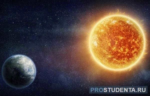
However, brave natural scientists like Giordano Bruno, Nicolaus Copernicus, and Isaac Newton disproved these beliefs and mathematically demonstrated that the Earth is actually a spherical shape with flattened poles and orbits around the Sun, rather than the other way around.
The planet’s composition is highly varied, despite its relatively small size compared to the rest of the solar system – its equatorial radius measures 6378 kilometers, while its polar radius is 6356 km.
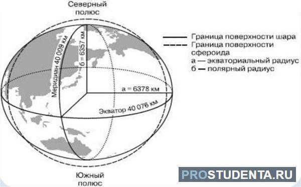
The circumference of one of the meridians is 40008 km, and the equator stretches for 40007 km. This observation also indicates that the Earth is slightly compressed at the poles, with a mass of 5.9742 × 10 24 kg.
Layers of the Earth
The Earth consists of various layers that create unique structures. Each layer possesses a symmetrical pattern, centered around a fundamental point. When observing a cross-section of the Earth, you will encounter diverse layers with distinct compositions, physical states, densities, and more.
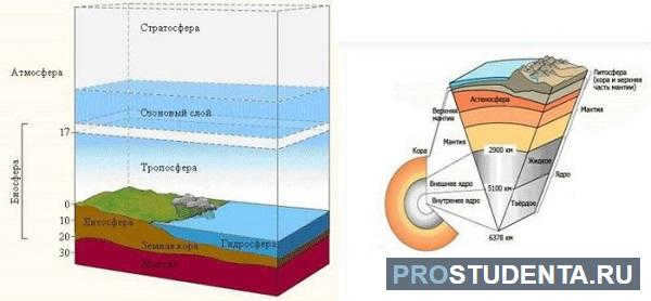
There are two main groups of shells:
- The inner shells consist of the Earth’s crust and the Earth’s mantle.
- The outer shells include the hydrosphere and the atmosphere.
The structure of each shell is the focus of specific scientific studies. Despite the rapid technological progress, not all questions have been fully answered by scientists.
The planet’s crust, which makes up only about 0.473% of its total mass, is one of its many layers. It extends to a depth of 5 to 12 kilometers.
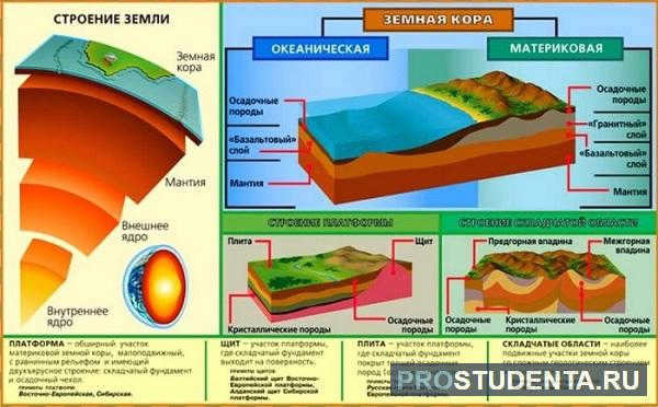
It is worth mentioning that scientists have hardly ever reached deeper depths, and to put it metaphorically, the crust can be compared to the skin of an apple in relation to its total volume. Further and more detailed research necessitates a completely different level of technological advancement.
If we examine the planet in a cross-section, we can identify the following types of the Earth’s crust in order of their depth inside the planet:
- Oceanic crust – primarily composed of basalts, located at the bottom of the oceans beneath extensive layers of water.
- The continental or continental crust – encompasses the landmass and is characterized by a highly diverse chemical composition, comprising 25% silicon, 50% oxygen, and 18% of the remaining major elements found on the Mendeleev table. To facilitate its study, the crust is further divided into the lower and upper crust, with the lower section encompassing the oldest formations.
As one delves deeper into the crust, the temperature gradually rises.
Mantle
The mantle is the primary component of our planet, filling the space between the crust and the previously mentioned core. Comprising numerous layers, it has a minimum thickness of approximately 5 – 7 km.
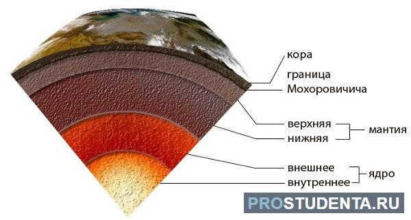
The current state of scientific and technological advancements prevents direct exploration of this particular region of the Earth, thus necessitating the use of indirect methods to gather information about it.
Frequently, the formation of new crust is accompanied by its interaction with the mantle, which is particularly active in underwater regions.
Presently, it is widely accepted that there are both upper and lower mantles, separated by the Mohorovich boundary. The proportions of this division have been reasonably calculated, but further refinement is necessary in the coming years.
Outer core
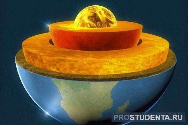
The core of the planet is not uniform. The extreme temperatures and pressure in this region lead to various chemical reactions and the distribution of masses and substances. The core is divided into two parts: the inner core and the outer core.
The outer core has a thickness of approximately 3000 kilometers. This layer consists of liquid iron and nickel. The temperature in this region ranges from 4400 to 6100 degrees Celsius as it gets closer to the center.
The Earth’s inner core
The central part of our planet, known as the inner core, has a radius of approximately 1,200 kilometers. It is the deepest layer, composed primarily of iron and nickel, with some impurities of lighter elements. The inner core is in a unique state similar to amorphous, and the pressure at this depth reaches an astonishing 3.8 million bars.
Have you ever wondered how far it is to the core of the Earth? The distance is approximately 6,371 kilometers, which can be easily calculated if you have the diameter and other parameters of the Earth.
Comparison of the thickness of Earth’s internal layers
The geological composition is occasionally assessed based on a parameter known as the thickness of the internal layers. The mantle is considered to be the thickest, hence being the most powerful.
In terms of power, the core is the second thickest layer. The outer crust ranks third in terms of this characteristic.
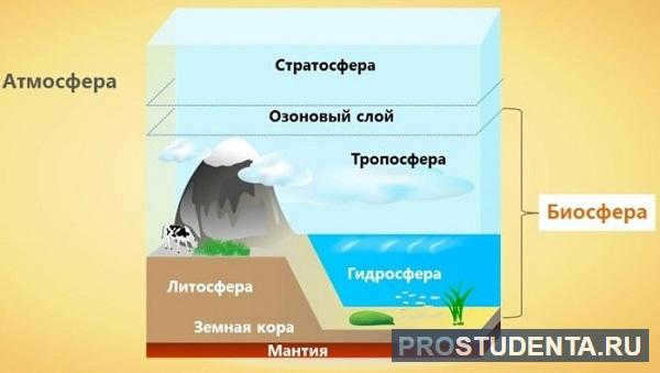
The Earth is a unique planet in the sense that it has external spheres that distinguish it from other celestial bodies, as recognized by scientists. These spheres include:
The study methods employed for these spheres vary significantly due to their diverse composition and subject of investigation.
Hydrosphere
The hydrosphere encompasses the entirety of Earth’s water, encompassing vast oceans that cover approximately 74% of the planet’s surface, as well as seas, rivers, lakes, and even smaller streams and reservoirs.
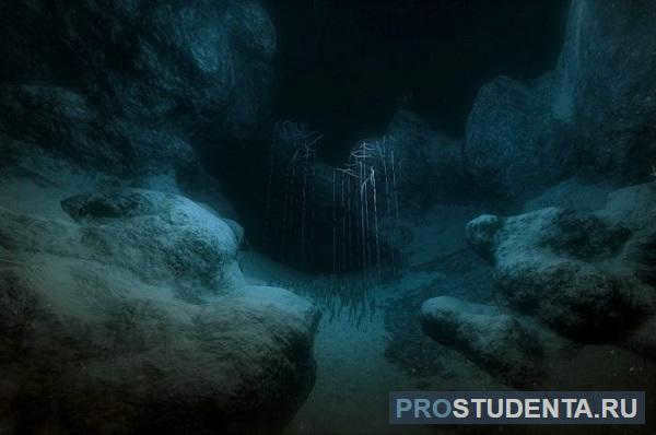
In the Mariana Trench region, the thickest part of the hydrosphere reaches approximately 11 kilometers. Water, which is vital for life, sets our planet apart from the rest of the universe.
The hydrosphere encompasses a volume of approximately 1.4 billion km 3. It is the place where life thrives and creates the necessary conditions for the atmosphere to operate.
The Earth’s atmosphere
The Earth is surrounded by a gas shell known as the atmosphere, which serves as a protective barrier between the planet’s interior and outer space. This atmosphere plays a crucial role in shielding the Earth from space objects such as meteorites and extreme temperatures, making it possible for life to thrive on our planet.
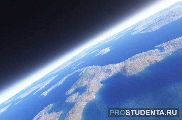
According to different calculations, the atmosphere’s thickness measures approximately 1000 kilometers. In close proximity to the Earth’s surface, the atmosphere exhibits a density of 1.225 kilograms per cubic meter.
The gaseous envelope is composed of 78% nitrogen, 21% oxygen, and the remaining portion consists of elements such as argon, carbon dioxide, helium, methane, and various others.
No matter how researchers investigate the matter at hand, the biosphere comprises the most crucial component of Earth’s composition – it serves as the habitat for all living organisms, including humans.
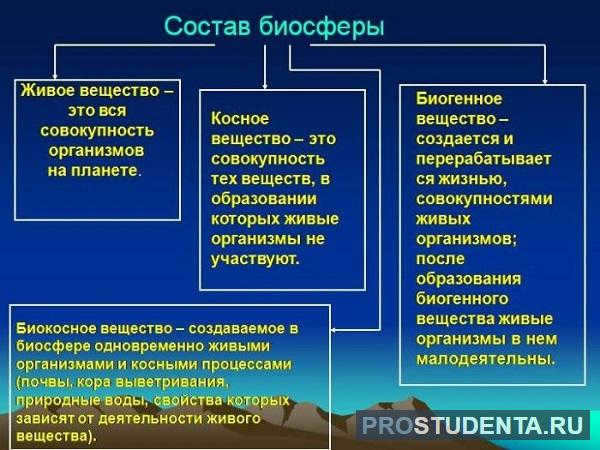
The Earth’s biosphere is home to not only a wide variety of living organisms, but also experiences constant transformations, largely due to the impact of human activities. V. I. Vernadsky, a prominent scientist, developed a comprehensive understanding of this sphere, while the initial concept was introduced by the Austrian geologist Suess.
Summary
The investigation of the Earth’s surface and its various layers has captivated scientists for many years. Despite appearing distinct, these spheres are intricately linked. The hydrosphere and atmosphere, essential for life and the biosphere, emerge from the Earth’s interior.

When studying geography or geology in school, one of the first topics students learn about is the internal structure of the Earth. This subject provides us with a general understanding of the Earth’s ancient history and the origins of life as we know it today on our planet.
Due to the inability to directly observe the depths of the Earth, our current knowledge is primarily based on the examination of the Earth’s surface through topographic studies, as well as the analysis of volcanic emissions and seismic waves.
The Earth can be divided into three main layers: the crust, mantle, and core. However, other layers can also be identified through their distinct chemical properties and density. Here are some important layers of the Earth that you should be familiar with.
The crust of the Earth
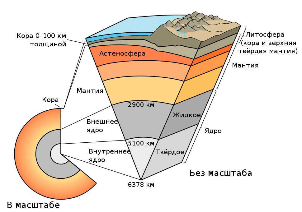
The outer layer of our planet, known as the crust, spans a depth of 5 to 70 kilometers. Comprised of three primary rock types – igneous, sedimentary, and metamorphic – the earth’s crust is predominantly composed of igneous rocks like granite and basalt.
The crust can be classified into two distinct categories: oceanic crust and continental crust. The Conrad Divide marks the boundary that separates these two types.
Oceanic crust
The oceanic crust, also known as Sima (magnesium silicate), is a layer of mafic rocks (basalt) that extends from 5 to 10 km below the sea floor. It has a density of about 3 g/cm3.
This crust is continuously formed through seafloor spreading, a process that takes place in the middle of ocean ridges. During seafloor spreading, magma rises from faults, spreads out, and cools, creating new oceanic crust. The age of the oceanic crust can be determined by its distance from mid-ocean ridges.
However, the formation of oceanic crust is balanced by its destruction in subduction zones. Subduction zones occur when one plate, whether it is oceanic or continental, is pushed beneath another plate and into the mantle.
Dividing the Continent
The continent is split by a geological feature known as the Continental Divide. This divide is made up of the continental crust, which is mainly composed of granite and is thicker (30-50 km) but less dense (2.7 g/cm3) than the oceanic crust. Plate tectonics play a role in the formation of both types of crust, but the continental crust is generally less disturbed.
The Upper Mantle
Beneath the Earth’s crust lies the mantle, which is divided into two main layers: the upper mantle and the lower mantle. The mantle as a whole makes up about 84% of the Earth’s volume.
The upper mantle is estimated to be about 640 km deep, while the entire mantle, including the lower mantle, reaches a depth of approximately 2900 km. The boundary between the Earth’s crust and the upper mantle is known as the Mohorovic discontinuity, or Moho for short. This boundary was first identified by Croatian seismologist Andrija Mohorovic in 1909, although its exact depth can vary.
This layer comprises of two mechanically distinct regions, specifically the lithosphere and the asthenosphere.
Lithosphere
The lithosphere is the solid and inflexible layer of the Earth, which incorporates the crust and the uppermost part of the upper mantle. The lithosphere exists in two forms; continental lithosphere (an extension of the continental crust) and oceanic lithosphere.
The continental lithosphere primarily consists of felsic rocks (rocks with a high silica content). On the other hand, the oceanic lithosphere is mainly composed of peridotite (an ultramafic rock with low silica content) and is denser than the continental lithosphere.
Asthenosphere: The Region of the Earth’s Mantle with Reduced Strength
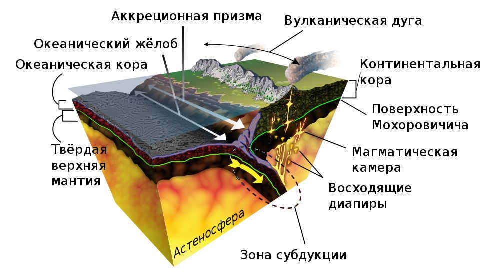
The asthenosphere is situated beneath the lithosphere and is characterized by its higher density and mechanical weakness. Typically found between depths of 80 and 200 km, it can also extend as far as 700 km below the surface in certain regions.
Due to the intense pressure and temperature, rocks in the asthenosphere become partially molten. Interestingly, this layer exhibits more plasticity than the lower mantle, despite the higher temperatures found there. The lithosphere-asthenosphere boundary (LAB) marks the transition between the two layers and is determined by noticeable changes in the chemical and thermal properties of the rocks.
Both the lithosphere and asthenosphere play a role in plate tectonics, a scientific theory that explains the movement of tectonic plates, which are large sections of the lithosphere.
To put it simply, the solid asthenosphere is buoyant on top of the pliable asthenosphere, resulting in the movement of tectonic plates. Plate tectonics are often associated with geological phenomena like earthquakes and volcanic eruptions.
Zone of transition
The zone of transition is a distinctive layer in the mantle of the Earth located between depths of 410 km and 660 km beneath the surface. In this region, due to extreme heat and pressure, rocks become denser and undergo structural transformations (crystallization).
Research has indicated that the mantle’s transition zone contains as much water as all of Earth’s oceans combined. However, this water solely exists in the form of hydroxide ions. At depths ranging from 525-660 km, hydroxide ions are trapped by olivine minerals like wadsleyite and ringwoodite.
Subsequent Layer of the Earth’s Mantle
Situated between the transition zone and the core is the lower mantle. This section stretches from approximately 660 km to about 2,900 km beneath the Earth’s surface. The temperature within the lower mantle varies from 1900 to 2630 K, depending on the depth. Despite being hotter and denser than the upper mantle, it is significantly less malleable.
The lower mantle primarily consists of minerals like calcium-silicate perovskite and ferropericlase, both of which are derived from ringwoodite.
According to the Preliminary Reference Earth Model (PREM) seismic model, the lower mantle can be subdivided into three distinct sections: the uppermost lower mantle, the mid-lower mantle, and the D layer.”
The interaction between the silicate-rich lower mantle and the nickel-iron outer core occurs at the core-mantle boundary. This boundary, also known as the Gutenberg discontinuity, is situated approximately 2890 km beneath the Earth’s surface and is characterized by seismic velocity variations.
Exploring the Core
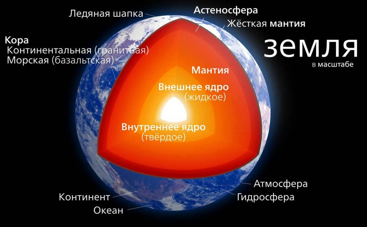
The core of our planet, known as the Earth’s core, is the most scorching and densest section. It is widely believed to consist mainly of Nickel and Iron. This core is segregated into two sections: the solid inner core and the fluid outer core, with the Bullen gap serving as the dividing line between the two regions.
Outer core
The outer core spans from a depth of 2,900 km to approximately 5,150 km beneath the Earth’s surface. While it is extremely challenging to accurately measure the temperature of the Earth’s core, scientists estimate that it ranges between 3000 K to 4500 K in its upper regions. As the outer core approaches its boundary with the inner core, temperatures can soar up to 8000 K.
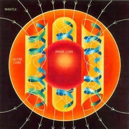
The outer core seems to possess a remarkably low viscosity, resulting in vigorous convection in this particular area. As per the dynamo theory, it is the liquid outer core made up of nickel and iron that drives the Earth’s magnetic field. The average strength of the magnetic field in the outer core (2.5 milliseconds) is roughly 50 times greater than that found on the surface.
The Earth’s inner core differs from the liquid outer core in that it is solid and has a radius of 1220 km. Its temperature is estimated to be around 5700 K, similar to the Sun’s outer surface temperature. Despite the inner core’s temperature surpassing the melting point of iron, it remains in a solid state due to the immense pressure exerted by the rest of the Earth.
Because the inner core is connected to the liquid outer core, it is possible that it rotates at a slightly different speed compared to the rest of the core. This hypothesis was supported by a study conducted in 2005.
By examining discontinuities in seismic waves, scientists were able to determine that the Earth’s inner core rotates at a faster rate than the rest of the planet, with an annual difference of approximately 0.3-0.5 degrees. This rotation speed is 50,000 times faster than plate tectonic movement.


