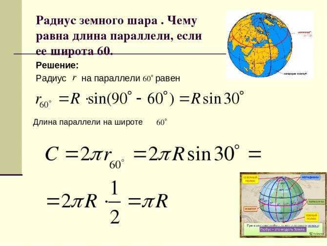
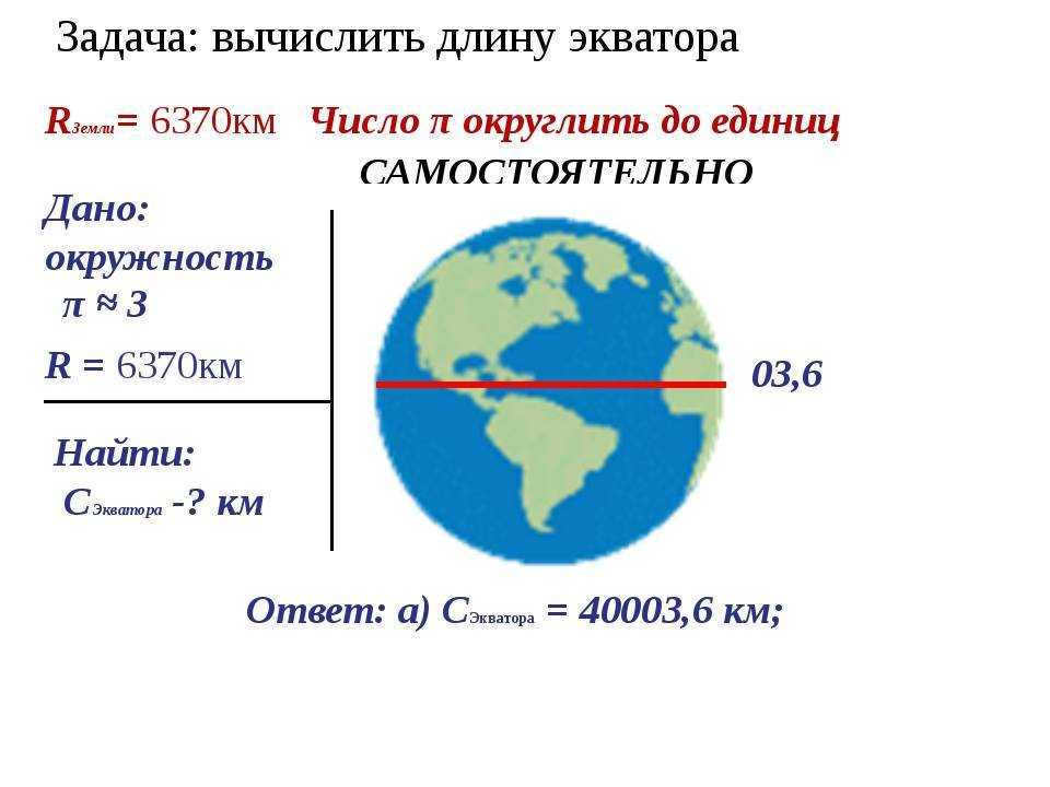
Scientists find the diameter of the Earth to be a practical matter of importance. It is determined by knowing the circumference of the planet along the equator.
The primary characteristics of the Earth
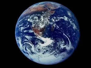
Planet Earth is estimated to be at least 4.5 billion years old. It belongs to the terrestrial group of planets, along with Mercury, Venus, and Mars. Unlike the gas giants (Jupiter, Saturn, Neptune, Uranus), these planets are composed of rocky surfaces with a thin layer. Among the terrestrial group, Earth is the largest and the fifth largest in the entire solar system.
The main distinction of Earth is that it is the only planet known to support life. This can be attributed to:
- The distance from the Sun, which is approximately 150 million kilometers.
- Surface temperature on Earth is typically around +13 ° C, with a minimum of -90 ° C and a maximum of +60 ° C.
- Water, which is essential for life, covers approximately 71% of the Earth’s surface.
- The Earth’s atmosphere is composed of approximately 78% nitrogen, 21% oxygen, and 1% argon.
In terms of physical characteristics, the Earth surpasses all other planets in the solar system:
- It has a mass of approximately 5.9722±0.0006×1024 kg;
- Its volume is approximately 1.08321×10¹² km³;
- Its density is approximately 5.514×10 g/cm³;
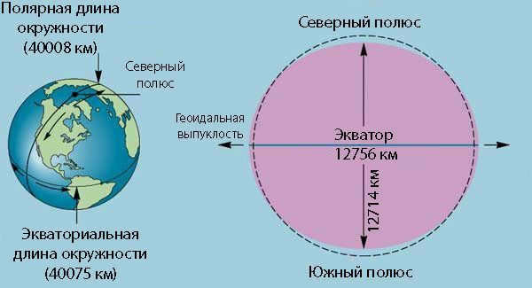
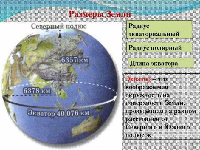
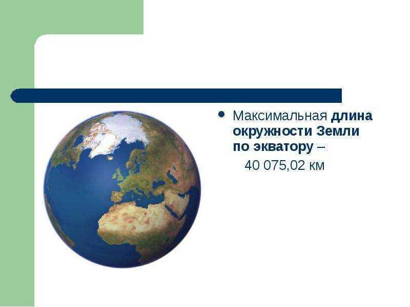
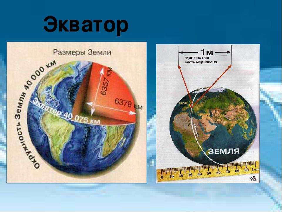
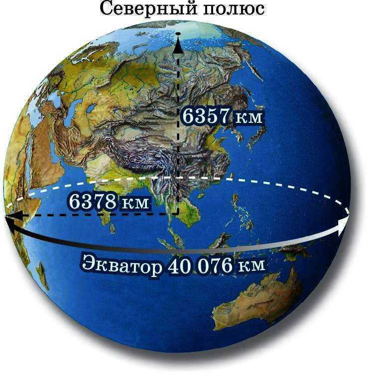
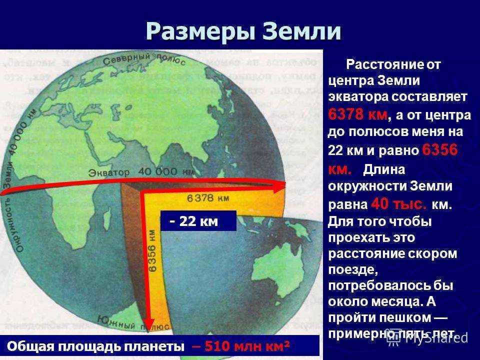
- Its circumference at the equator is approximately 40075.16 km, and its diameter is approximately 12756.1 km;
- Between the poles, the Earth’s parameters are slightly smaller, with a circumference of approximately 40008 km and a diameter of approximately 12713.5 km.
The Earth is the most dense because it is the only planet with a solid inner core, which takes up approximately 30% of its volume. It is surrounded by a liquid mantle (70-80% of its volume) and a crust (1%).
Shape of the planet
Our planet is commonly referred to as a sphere, but this is technically incorrect. The variation in elevation between ocean trenches and mountain peaks is insignificant on a global scale. The difference in height between the lowest point, the Mariana Trench, and the highest point, Mount Everest, is only 19 km.
The shape of the Earth is primarily influenced by gravity. The mass is drawn towards the center (the core), causing the celestial body to contract and take on a spherical shape. The centrifugal force generated by the Earth’s rotation is greatest at the equator. As a result, the equatorial region has the largest circumference and diameter.
What is the purpose of the equator and why is it significant?
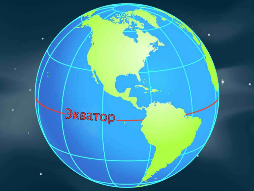
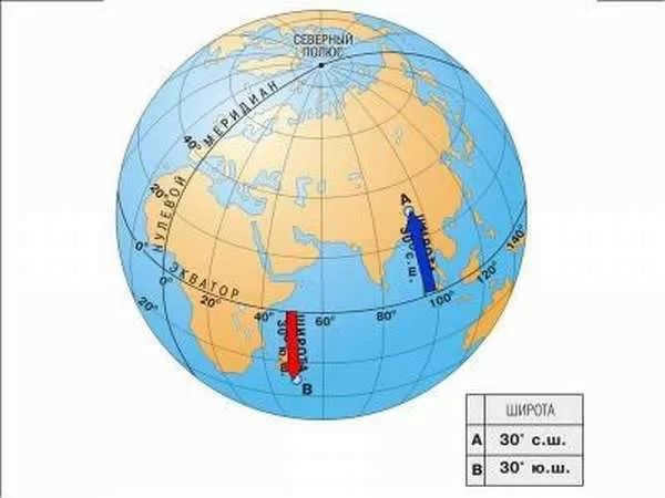
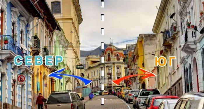
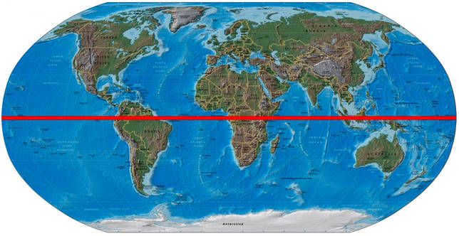
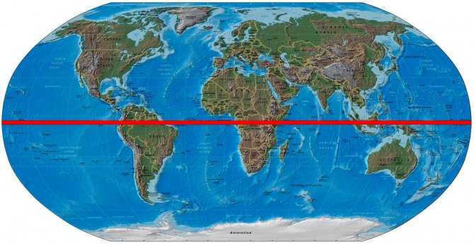
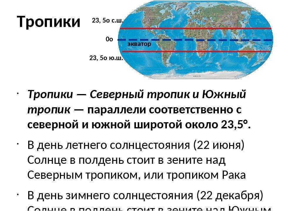
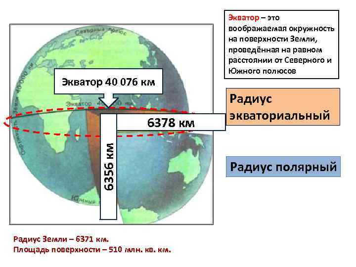
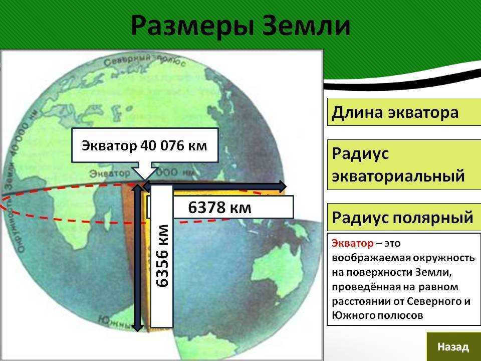
The equator is an imaginary line that runs along the Earth, perpendicular to its axis of rotation, and at an equal distance from the North and South Poles. Due to the Earth’s spherical shape, the equator is the longest parallel. Its position in relation to the plane of the Earth’s orbit can vary between 22-24.5° due to the gravitational forces exerted by other celestial bodies, such as the planets and the Sun.
One of the significant characteristics of the equator is that it experiences equal day and night throughout the year, with no deviations. During the equinox, which occurs twice a year, the sun’s rays are directly overhead at noon, creating a vertical angle. On other days, the angle is not significantly different, resulting in the equatorial regions receiving the highest amount of ultraviolet light. Consequently, these areas have a perpetual summer climate, with hot and humid air due to consistent evaporation.
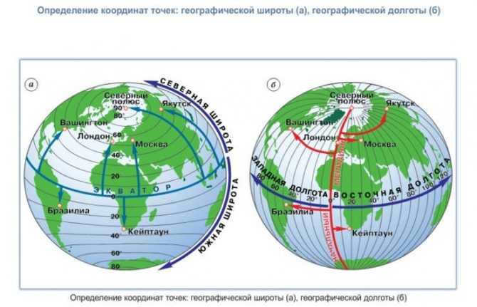
To perform calculations, it is necessary to divide the planet into parallels and meridians. The equator has a geographic latitude of 0 °. This serves as the reference point for all Earth’s coordinates, dividing it into two equal halves.
Parallels and meridians are utilized to ascertain the location of objects. They are employed for navigation in the air, on land, and in water. Furthermore, they help distinguish climatic zones and time zones.
Measuring the Earth’s Circumference Using Geometry
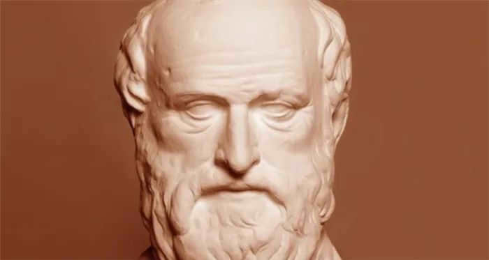
In order to determine the circumference of the Earth at the equator, specialized instruments and space satellites are typically used. However, it is also possible to obtain data through the application of geometric principles, without the need for complex tools. This approach was first implemented by the ancient Greek scientist Eratosthenes.
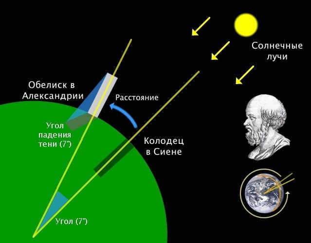
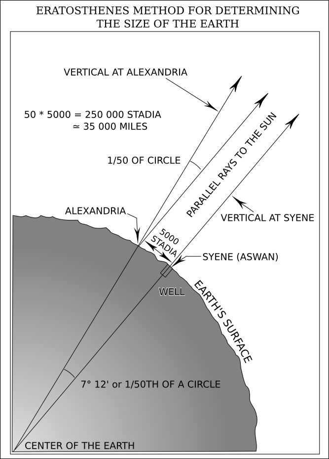
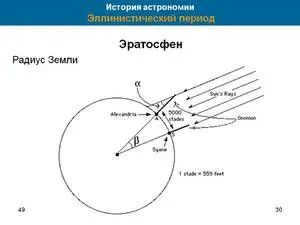
Legend has it that travelers informed Eratosthenes that on the day of the summer solstice, they observed that the bottoms of the deepest wells were illuminated and objects did not cast shadows. The sun was directly overhead. This phenomenon occurred 500 miles south of Alexandria, in Siena. Eratosthenes, being an astronomer, knew that in his hometown, objects did cast shadows and the sun did not appear directly overhead at the bottom of deep wells.
During the midday of the summer solstice, Eratosthenes conducted a measurement of the shadow cast by the obelisk in the city; he had knowledge of its height. Utilizing this information, I made a calculation to determine the length of the hypothetical line connecting the tops of the obelisk and its shadow. With these measurements in hand, I proceeded to calculate the angles of the imaginary triangle, which turned out to be 7°. This discovery revealed that Siena was displaced in relation to Alexandria.
An angle of 7° is approximately 1/50th of a complete circle, which always measures 360°. The astronomer continued his calculations and multiplied the distance to Siena by 50. The resulting figure represented the length of the Earth’s circumference, which amounted to 25,000 miles. Modern research has confirmed that the scientist’s estimation was not far off: the equatorial circumference of the planet is approximately 24,894 miles or 40,075 km.
Eratosthenes’ miscalculation was not caused by the simplicity of the calculations he employed. This technique is precise and is still employed today, albeit with more sophisticated instruments. The scholar was unaware of the precise distance between the cities. In ancient times, it was determined by the number of days it took for a caravan to travel between them.
The second factor contributing to the inaccuracy is that Alexandria and Siena are situated on different meridians. Nowadays, the circumference between objects that lie on the same meridian is calculated.
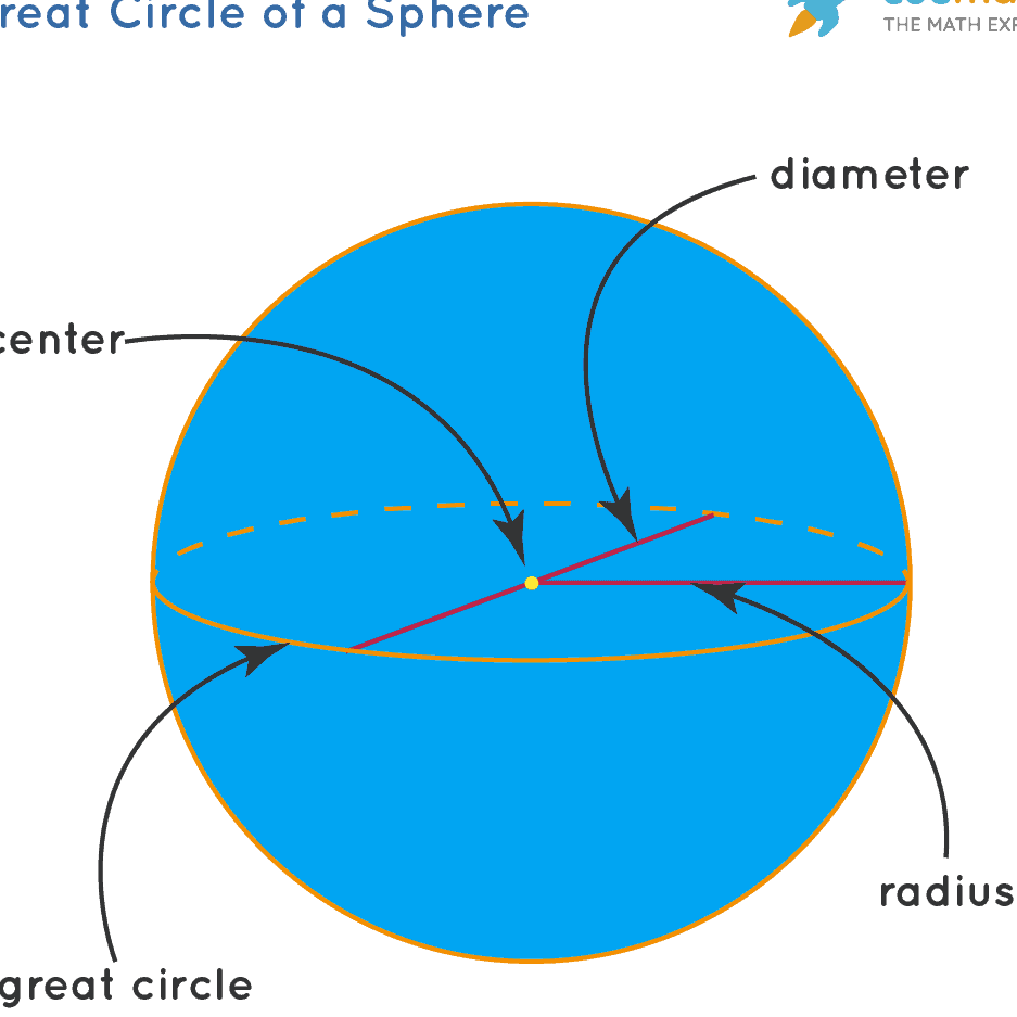
It is not difficult to determine the radius and diameter of the globe if you know its circumference. The following formulas can be used: d = l/π; r = ½*π. Here’s what each letter represents:
- d represents the diameter, which connects opposite sides of the circle and passes through the center.
- l represents the length of the circle, which is a line at an equal distance from the center.
- r represents the radius, which is a line drawn from the center to an arbitrary point on the circle.
- π represents a number equal to 3.14. It is an infinite number, so the more digits after the decimal point, the more accurate the calculation.
You don’t need to use both formulas. The diameter and radius are interrelated. Calculate one parameter, and then you can determine the other: the diameter is twice the radius, and vice versa.
How long would it take to circumnavigate the planet on foot?
By calculating the length of the equatorial circle in kilometers and considering the estimated walking speed, we can determine the time it would take to go around the Earth. The formula used for this calculation is: t = S/V. In this formula, S represents the distance to be covered and V represents the velocity.
In the case of walking around the Earth along the equator, the distance would be approximately 40,075 km. Assuming an average walking speed of 6 km/h, we can substitute these values into the formula: 40,075/6 = 6,679 hours. When converted to days, this amounts to approximately 278 days.
It is important to note that these calculations are purely hypothetical, as the equator only crosses through certain landmasses such as America, Africa, and Indonesian islands. The remaining portion of the journey would involve crossing oceans such as the Atlantic, Indian, and Pacific.
Curious facts about the Earth’s equator
The region surrounding the equator is known for its hot and humid climate. It is home to the world’s most diverse flora and fauna, with dense forests and some areas that are virtually impenetrable. The summer season lasts throughout the year, with average temperatures ranging from +25 to +30°C. The temperature at night is similar to that during the day, as the land retains the heat from the sun. Rainfall is a common occurrence, with almost daily showers.
The climate of the equator attracts tourists, although not all countries in this region have the ideal conditions. The Maldives, Ecuador, Brazil, and Kenya are among the countries that attract the largest number of visitors each year.
The equatorial countries also offer a range of geographical attractions:
- The equator passes through 33 islands, with 17 of them falling within the territory of Indonesia. Some of these islands are not located in the ocean: 2 can be found in a lake on the Indonesian island of Kalimantan, 9 are situated at the mouth of the Amazon River, and another 5 are located on Lake Victoria in Africa.
- There are a total of 14 countries that are situated on the equator. One of these countries is Ecuador, which is named after the equator that runs through it. It is a great challenge for any traveler to successfully cross all of these countries along the equator.
- With the exception of Gabon and Somalia, almost all equatorial countries have erected memorial signs to commemorate the significance of the equator. Some of the most stunning signs can be found in Brazil and Ecuador.
- The Galapagos archipelago is home to an active volcano called Wolf, which is located on both sides of the equator.
- Not far from Quito, the capital of Ecuador, lies the majestic Cayambe volcano, which stands at an impressive height of 4690 meters. This awe-inspiring volcano is adorned with glistening eternal ice on its slopes.
- The mighty Congo River in Africa gracefully traverses the equator not once, but twice, making it a unique natural wonder.
Humanity has harnessed the unique geographical characteristics of the equator to its advantage. The Earth’s rotation at this latitude is 1.4 times faster than the speed of sound, making it an ideal launching point for space satellites. By launching from this region, satellites immediately gain supersonic speed, resulting in a 10% savings in fuel. Furthermore, geostationary communication satellites are strategically positioned in orbit above the equator, allowing for faster and more efficient signal transmission to Earth compared to other regions.
Calculating the Length of the Earth’s Circumference 2.5 Thousand Years Ago: Exploring the Largest Diameter and Distance Travelable by Foot
The measurement of the Earth’s diameter holds great significance for scientists. It enables the calculation of our planet’s surface area, the distance to its core, and aids in the creation of maps as well as space exploration. Join us as we delve into the techniques used to determine these parameters and uncover their respective values.
Essential characteristics of Earth
The primary distinction between Earth and other celestial bodies in our solar system lies in the existence of life on our planet. Here are the fundamental parameters of Earth:
- Distance from the Sun: approximately 150 million kilometers. This distance is optimal for the emergence and sustenance of life. If Earth’s orbit were just a few million kilometers closer or farther away, the conditions for the development of life would be significantly compromised.
- Orbital period: Earth takes 365 days, 5 hours, 48 minutes, and 46 seconds to complete one revolution around the Sun. It completes one rotation around its axis in 23 hours, 46 minutes, and 4 seconds. Every 100 years, its rotational speed slows down by 0.017 seconds. It would require 140 million years for the length of a day to increase by one hour.
- The Earth experiences distinct seasons due to its axial tilt of just over 23 degrees, which determines the angle of its rotation in relation to its orbital plane. If this tilt were slightly decreased or increased, the planet would have less favorable climate conditions and a larger portion of its surface would be covered in glaciers.
- The average temperature on Earth is approximately 15°C.
- Water covers about 71% of the Earth’s total surface area, with a mass of 1460 million billion tons. In contrast, the atmosphere weighs significantly less, with a mass of just over 5 quadrillion tons.
- About 21% of the Earth’s atmosphere is composed of oxygen, while nitrogen, a biologically inert gas, makes up 78% of the atmosphere.
- The Earth has a mass of approximately 6∙10 24 kilograms.
- The volume of the planet is estimated to be 1.08∙10 12 cubic kilometers.
- The Earth’s surface area is approximately 510 million square kilometers.
- The density of the Earth is approximately 5.5 grams per cubic centimeter.
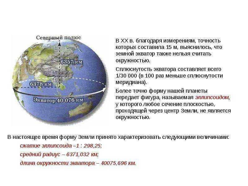
- The Earth’s circumference is approximately 40,075 kilometers at the equator and 40,008 kilometers at the poles.
- The diameter of the Earth is approximately 12,756 kilometers at the equator and 12,713 kilometers at the poles.
- The Earth has an average radius of approximately 6,371 kilometers. The center of the Earth’s core is located at this distance from the surface. The equatorial radius of the Earth is approximately 6,378 kilometers, while the distance to the center of the Earth at the poles is approximately 6,356.5 kilometers.
- The Moon is the closest celestial body to the Earth, with an average distance of approximately 384,000 kilometers.
The Form of the Planet
When inquired about the form of the Earth, the majority of individuals will respond that it is spherical. However, this response is incorrect. The planet is subject to gravitational forces: its immense mass is drawn towards the core, resulting in a continuous compression. The strongest centrifugal force occurs due to the Earth’s rotation around its own axis, specifically at the equator.
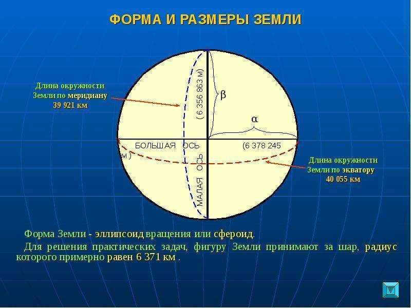
The Earth can be described as an “irregular sphere”. Compression is the underlying cause for the equatorial diameter of the planet being slightly larger than at the poles. Scientists classify the shape of our planet as resembling a “flattened ellipsoid”.
Interestingly, the neglect of Earth’s compression at the poles led to a discrepancy of 200 microns in the meter standard established in 1795.
The local terrain also plays a significant role in the formation of a planet’s shape. However, it does not have a global impact on the overall shape of the planet. For instance, the variation in height between Mount Everest and the Mariana Trench is approximately 19 kilometers. In the grand scheme of things, this difference is relatively small. The highest point on Earth, considering the Earth’s curvature, is the summit of the Chimborazo volcano situated in Ecuador.
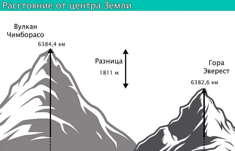
Difference in distance between the center of the Earth and the summit of Chimborazo volcano and Mount Everest
What is the equator and its purpose
The equator is a line perpendicular to the axis, running along the Earth’s surface at an equal distance from the poles.
Along this line, day and night are of equal length. However, due to atmospheric refraction, the day is slightly longer by a few minutes. Twice a year (during the equinoxes), the Sun is directly overhead, and its rays are directed perpendicularly to the Earth’s surface. The latitude at the equator is 0°.
The equator plays a crucial role in determining the latitude of a geographic feature. All points located south of this imaginary line are considered to have southern latitude, while objects located north of it have northern latitude.
Measuring the Earth’s Circumference
Calculating the size of the Earth is possible using advanced instruments and satellites. However, before the advent of these technologies, mathematical methods were employed. In the 18th century, scientists P. Meschen, A.M. Lejeandre, and C. Cassini utilized the technique of triangulation to measure the length of the Earth’s circumference.
Let’s imagine a scenario where we have the task of determining the distance between points that are located at a significant distance from each other, spanning several hundred kilometers. In order to accomplish this, it is necessary to establish a reference network across the terrain. One effective approach to achieve this is by utilizing triangles. These triangles would have vertices at specific locations that are situated at an elevated altitude. By constructing imaginary pyramids on these vertices, we can ensure that they are oriented towards the nearby points.
The design of these imaginary figures should be optimized to facilitate the setup of an angle gauge and enable accurate calculation of the angles involved. Within one of these triangles, it is possible to measure one side that extends across level ground. This particular side serves as the baseline for subsequent calculations.
An efficient method to measure the length of the equator entails multiplying the number of kilometers in one degree by 360.
The process of measuring the circumference starts with the triangle, which serves as the baseline. By using the side and angle measurements, the remaining sides of this shape can be determined. One of these sides also acts as the baseline for calculating the sides of another triangle. Through mathematical calculations, the parameters of the final triangle can be found, allowing for the determination of the meridian arc’s value. The longer the meridian arcs, the more accurately the desired value – the radius of the Earth – can be calculated.
Once the length of the meridian arc is known, it becomes easier to calculate the length of one degree. This method forms the foundation of geodesy.
Calculating the Radius and Diameter of a Planet
Calculating the radius and diameter of a planet is a straightforward process. The following formulas can be used:
- d=l/π – this formula calculates the diameter of the planet;
- r=½π – this formula calculates the radius of the planet;
- d represents the diameter;
- l represents the circumference of the circle;
- r represents the radius, which is a line drawn from the center of the circle to any point on the circle;
- π is a mathematical constant approximately equal to 3.14 and represents the ratio of the circumference of the circle to its diameter.
Measurement of the Earth’s Circumference in Ancient Times
Ancient Greece had knowledge of the Earth’s circumference dating back to ancient times. The calculations necessary for this measurement were conducted by Eratosthenes, an ancient Greek mathematician, astronomer, and geographer. Eratosthenes discovered that on the solstice day of June 21st in Siena, which was located approximately five hundred miles from Alexandria, the bottom of wells would be illuminated at noon with no shadows detected from objects. This indicated that the sun was directly overhead in that region. However, in Alexandria, no such phenomenon occurred.
During the summer solstice, Eratosthenes measured the shadow cast by the city obelisk (whose height he knew). Through this measurement, he determined that Alexandria and Siena were separated by approximately 7 degrees of latitude.
The astronomer conducted additional calculations. 7° represents approximately one fiftieth of a complete circle measuring 360°. By multiplying the distance between Siena and Alexandria by 50, the mathematician arrived at the figure of 25,000. This is the estimated mileage of the Earth’s circumference.
Eratosthenes conducted a measurement of the Earth’s circumference.
The calculation of the Earth’s circumference by Eratosthenes was slightly less than the actual value. This discrepancy was not due to inaccurate calculations, as this method of determining the Earth’s circumference is quite precise. During Eratosthenes’ time, the exact distance between the two cities was unknown. Additionally, the fact that both cities were situated on different meridians was not taken into account by the scientist.
In the Middle Ages, the church prohibited any references to such research. It was only in the 16th century, with Ferdinand Magellan’s circumnavigation of the globe, that it became possible to verify that the Earth does indeed have a spherical shape and that its circumference is approximately 40,000 kilometers.
How much time does it take to complete a full trip around the Earth on foot?
If we know the length of the Earth’s circumference along the equator in kilometers, it is possible to calculate the time it would take to complete a full trip on foot. By assuming the average walking speed of 6 kilometers per hour, we can use the formula t = S / V to estimate that it would take approximately 6700 hours, or 278 days.

The duration required to complete a continuous journey around the Earth can be estimated in the following manner. Assuming that the hypothetical pedestrian walks for 6 hours per day, it would take approximately 1110 days, which is equivalent to over 3 years, to accomplish such a feat.
Fascinating Facts about the Equator
The Earth’s equator boasts a consistently hot and humid climate. The lush rainforests of the Amazon, equatorial Africa, and Indonesia are home to a diverse range of plant and animal species. During the day, temperatures range between 25 and 30 degrees Celsius, while nights remain relatively warm due to the sun’s lingering warmth on the Earth’s surface.
However, the equator also holds intriguing geographical distinctions:
- It traverses over 30 islands.
- It cuts through 14 countries.
- Ecuador derives its name from the equator.
- Many equatorial nations have erected monuments and memorials to commemorate the zero parallel.
- The Congo River, which runs through the heart of Africa, crosses the equator twice;
- Due to the rapid rotation of the Earth in this area, it is the most convenient location for satellite launches as they can reach higher speeds.
The size of the Earth is a crucial factor in astronomy and holds significant practical value. It allows for the determination of the Earth’s diameter and radius through straightforward mathematical calculations.
Size of the Earth
The size of the Earth can be easily calculated by measuring its circumference at the equator. It is fascinating to note that even in ancient Greece, people were aware of the Earth’s equatorial length. Nowadays, we have precise measurements of the planet’s dimensions. It is worth mentioning that Earth is the largest planet in its group.
Measuring the Circumference of the Planet: An Ancient Greek Scientist’s Method
Utilizing sophisticated instruments, scientists today can accurately measure the circumference of the Earth. However, this was not always the case. In fact, one ancient Greek scientist, Eratosthenes, was able to determine the Earth’s circumference using only his knowledge of geometry.
According to ancient legends, Eratosthenes made his calculations on the day of the summer solstice, when the Sun is at its highest point in the sky. On this day, he observed that objects in Siena, located 500 miles south of Egyptian Alexandria, cast no shadows, and even the deepest wells were fully illuminated. Using this information, along with his understanding of geometry, Eratosthenes was able to calculate the Earth’s circumference.
Eratosthenes was aware that in Alexandria on June twentieth, objects always cast a shadow and the Sun does not illuminate the bottom of deep wells. By measuring the length of the shadow from the obelisk (the height of which he knew), Eratosthenes calculated that Siena was located 7 degrees to the south of Alexandria. This difference further confirmed the fact that our planet is spherical. If it were not, the Sun would be directly overhead at all points on the planet simultaneously. Furthermore, it is simple to calculate the diameter based on the circumference, using the value of π. The radius of the Earth would be half of the diameter.
The measured angle value corresponded to 1/50th of a complete circle, which is equivalent to 360 degrees. In his further computations, Eratosthenes multiplied the distance between Alexandria and Siena by 50. Consequently, he estimated the circumference of the Earth to be 25,000 miles (or 40,075 kilometers). The inaccuracy arose due to the oversight of the fact that Alexandria and Siena lie on different meridians, and the approximate distance between these cities was utilized. Nonetheless, for that era, such a measurement represented a significant scientific achievement.
Eratosthenes came up with a method to calculate the Earth’s radius and circumference.
Fernan Magellan’s journey around the world provided further evidence that our planet is round and that it has a circumference of over 40,000 kilometers. This completely debunked the idea of a “flat” Earth.
Recent measurements have accurately determined the size of the Earth.
- The Earth’s surface area is 510,083,000 square kilometers.
- The average diameter of the Earth is 12,742 kilometers.
- The Earth’s radius is 6,371.3 kilometers.
However, the equatorial radius of the Earth is slightly larger at 6,378.1 kilometers, while the polar radius is smaller at 6,356.7 kilometers.
The circumference of the North and South poles is slightly smaller than that of the equator: 40,007 kilometers. In our daily lives, this difference is not significant.
If someone were to walk over 40,000 kilometers along the equator, it would take them 333 days, assuming they never stopped and maintained a speed of 5 kilometers per hour. However, if a person only walked 6 hours a day at the same speed, it would take them approximately 1,330 days or 3.6 years to complete such a journey.
Fascinating facts about the Earth’s equator
The region bordering the equator boasts a warm and humid climate, with average temperatures ranging from 25 to 30 degrees Celsius year-round. Daily rainfall is a common occurrence in equatorial countries, which contribute to their unique characteristics.
- There are a total of 14 countries situated on the equator, and one of them is named Ecuador in its honor.
- The equator passes through 33 islands, with 17 of them located in Indonesia.
- With the exception of Gabon and Somalia, all equatorial countries have commemorative markers.
- The Galapagos archipelago is home to the Wolf volcano, which is interestingly situated on both sides of the equator.
- The Congo River, located in Africa, intersects the equator twice.
What’s intriguing is that at the equator, the Earth spins on its axis 1.4 times faster than the speed of sound. As a result, it becomes a more advantageous spot for launching space satellites. This launch location enables a savings of up to 10 percent of rocket fuel.
Discovering the Earth’s Radius and Diameter
In order to determine the Earth’s radius, one can divide the length of the circle by the value π (approximately 3.14). The diameter of the Earth can then be found by dividing the obtained radius by 2.
Why does the Earth have two distinct values for its circumference?
The reason is that the Earth is not a perfectly spherical object. Its shape is influenced by the force of gravity. The mass of the planet is pulled towards its center, causing it to become compressed. Additionally, due to the effects of centrifugal force, the circumference of the Earth is greatest at the equator. This imaginary line is perpendicular to the planet’s axis of rotation. As a result, the Earth’s poles become slightly flattened, causing a slight bulge at the equator.
The extent of this equatorial bulge is more than 42 kilometers.
Why does the Earth lack a boundary?
Only two-dimensional shapes can possess a boundary. Our planet, on the other hand, has a roughly spherical shape. As a result, the concept of the “boundary of the Earth” does not hold any meaning.
What is the weight of the Earth?
Examining the dimensions of our planet would be incomplete without considering another parameter – its mass. The Earth’s mass is equivalent to 6*10^24 kilograms. The planet’s volume exceeds 1.08 trillion cubic kilometers. Consequently, the density of the Earth is approximately 5.5 grams per cubic centimeter.
According to an ancient belief, during the summer solstice, when the sun is above the horizon, objects in the surrounding area do not create shadows. In deeper wells, the bottom would be illuminated. This phenomenon was observed in Siena, which is located 500 miles south of Alexandria, Egypt.
What is the Earth’s circumference at the equator in miles and kilometers?
Where does the equator pass through, what is it, when was it discovered, and why did scientists need to establish this remarkable line? Let’s delve into the details…
The equator is an imaginary line that runs through the center of our planet. It has a latitude of 0 degrees. The equator serves as a point of reference for scientists to make various calculations, which is explained below. It divides the Earth into two equal halves.
It is of utmost importance to note that in the region where the equator intersects, the duration of night is always equivalent to that of day and remains unchanged, even by the slightest fraction of a second.
The equatorial belt is exposed to the highest levels of ultraviolet radiation. Thus, the further away a location is from the aforementioned line of reference, the lesser the quantity of heat and light it receives. Consequently, this explains why the hottest temperature measurements are recorded in close proximity to the reference line.
Mission

In order to perform various calculations, scientists require knowledge about the unique dividing lines on planets, including equators, latitudes, and meridians.
These lines play a crucial role in determining the location of different objects and enable airplanes to navigate through the atmosphere and ships to navigate underwater.
Furthermore, these lines are instrumental in dividing the planet into distinct climatic zones or multiple regions.
Undoubtedly, the measurement of the Earth’s circumference along the equator is an essential metric to consider. Its significance extends beyond disciplines like geodesy and basic geography, encompassing astrology and astronomy as well.
What is the exact measurement of the Earth’s circumference at the equator?
Based on precise calculations, the Earth’s equator measures approximately 40075 kilometers in length. On the other hand, when converted to miles, the equator spans a distance of 24,901 miles.
Another important concept to consider is the distance from the pole to the equator, which has a radius of 6356 kilometers and 6378 kilometers, respectively.
Fascinating information

The regions surrounding the imaginary line experience a warm and humid climate.
It is not by chance that these areas are bustling with activity. The equatorial zone is home to a diverse range of plant and animal species.
Ecuador’s forests are renowned for their dense foliage, with some areas remaining untouched and impenetrable despite advancements in scientific technology.
Rainfall in the equatorial zone is frequent and intense, resulting in vibrant and colorful surroundings.
One notable feature of the region is the active volcano known as Wolf, which straddles both sides of the equator.
Caution: The average annual temperature in this area reaches 25-30 degrees Celsius.
Note: At the equator, there exists a glacier situated on the slopes of a volcano named Kayambe, which rests at an altitude of 4,690 meters above sea level.
This is an incredible destination, particularly for astronauts. The reason being that the velocity of the Earth’s rotation along this route reaches 460 meters per second.
The speed of sound only reaches 330 meters per second. Consequently, all spacecraft launched from this point are already launching at supersonic speeds.
We discussed the length of the Equator and its significance in the modern human life. Three countries were mentioned.
Without these imaginary lines, it would be impossible for people to locate islands and famous cities. All airplanes and ships are directed towards a fictional map of a geographical area where the major positions are precisely parallel, held by a line that traverses the globe in two halves.
The Congo River, famous for its unique path, crosses the equator not once, but twice, making it a remarkable natural wonder.
Speaking of the equator, it is an imaginary line that divides the Earth into two halves, known as the Northern Hemisphere and the Southern Hemisphere. It is the midpoint between the North and South Poles and has a latitude of 0 degrees.
To calculate the length of the Earth’s equator, one can use the following formula: length = price × speed. The length is measured in kilometers, and the speed can be estimated using a pedometer. By multiplying the price and speed, one can determine how long it would take to complete a full circle around the Earth.
The formula t = s:v is used for this calculation, where t represents time, s represents length, and v represents speed. By plugging in the values, one can easily calculate the time it would take to circle the Earth.
What you should understand regarding the equator
The territory adjacent to the equator is encompassed by vast stretches of seas and oceans, and it is not uncommon for certain vessels to traverse these imaginary boundaries multiple times within a single day. However, sailors have long upheld a tradition of commemorating such occasions with modest festivities. In his literary work, Vladislav Krapivin recounts:
'However, I dedicated an entire chapter to detailing the experience of our ship crossing the equator…'.
Some fascinating facts about Ecuador:
- Spanning a distance of 40,000 km around the globe, this line intersects 14 countries, including prominent ones like Brazil, Ecuador, and Congo;
- Quito, the capital of Ecuador, is bisected by this equatorial line;
- The island of Sumatra is also divided in half by the Equator.
In the annals of ancient history, individuals across the globe and specifically in the area of Ecuador have long pondered the concept of kilometers. It is a peculiar twist of fate that the pioneering figure to embark upon the daunting task of calculating distances around the Earth in kilometers was none other than the esteemed ancient Greek mathematician Eratosthenes. This remarkable scholar, hailing from the first century BC, was constrained by the limited technological resources available during his era.
Thanks to his advanced cleverness, Eratosthenes successfully tackled the challenging problem of determining the circumference of the Earth. Mathematicians devised a method involving measuring the time it takes for a beam of light to reach a well, which allowed them to calculate the Earth’s radius. With that information in hand, they were then able to solve the relatively simple task of finding the length of the equator.
It is worth noting that Eratosthenes’ estimation of the Earth’s circumference in kilometers was remarkably accurate. According to the ancient Greek scholars, the equator measures 39,690 kilometers. Even by today’s standards, this figure remains quite close to our current understanding of the length of the equator. Rounding it up to the nearest thousand kilometers would hardly make any difference.
Reasons behind the creation of the equator
The creation of the equator holds great significance in the field of modern geodesy. As one approaches the equator, the angle at which the sun sets becomes increasingly straight. This practical observation leads to the conclusion that there is no variation in temperature between summer and winter at the equator.
Moreover, understanding the expanse of the equator allows us to delve into the past, taking into account both lowland and mountainous regions and examining the farthest points in Earth’s history. This research calls for the expertise of specialists in fields such as geology, geography, geodetic measurements, and other related sciences.
The shape of the Earth is influenced by gravity. When mass is pulled towards the center (core), it causes the object to compress and form a spherical shape. At the equator, the centrifugal forces resulting from the planet’s rotation are stronger. As a result, the equatorial region has the largest perimeter and diameter.
The adjacent region of Ecuador experiences a warm and humid climate. The average temperatures range from 25-30°C all year round. Daily rainfall is also a common occurrence. Ecuadorian nations possess fascinating characteristics.
- There are 14 countries situated on the equator, with Ecuador being named after this imaginary line.
- The equator passes through 33 islands, with 17 of them located in Indonesia.
- Except for Gabon and Somalia, all equatorial countries have commemorative markers.
- The Galapagos Archipelago is home to the Wolf Volcano, which is unique as it straddles both sides of the equator.
- In close proximity to Quito, the capital of Ecuador, lies the Cayambe volcano. It stands at approximately 4.7 kilometers in height. Despite its equatorial location, the slopes of the volcano are covered in snow.
- The Congo River, located in Africa, intersects the prime meridian twice. A fascinating fact is that at the equator, the Earth spins on its axis 1.4 times faster than the speed of sound. This makes it an ideal location for launching space satellites, as it saves up to 10 percent of rocket fuel.
How to determine the Earth’s radius and diameter
Calculating the Earth’s diameter involves dividing the circumference of the planet by the mathematical constant pi (approximately 3.14). To find the Earth’s radius, one simply needs to divide the diameter by 2.
It’s important to note that the Earth’s shape is not a perfect sphere due to the influence of gravity. As mass is drawn towards the center, the planet contracts. Additionally, centrifugal forces cause the circumference at the equator to be greater. This equatorial line is perpendicular to the planet’s axis of rotation. The Earth’s poles are slightly flattened, resulting in a slight bulge along the equator. The length of the Earth’s equator exceeds 42,000 kilometers.
Why the Earth lacks a perimeter
Only geometric figures can possess a perimeter. Conversely, our planet possesses a spherical shape. Consequently, the notion of “the perimeter of the Earth” is devoid of meaning.
Examining the dimensions of our planet would be unfinished without considering an additional parameter (mass). The Earth measures 6*1024 km in size. The planet’s surface area exceeds 1.08 trillion square kilometers. Therefore, the Earth’s density equates to approximately 5.5 grams per cubic centimeter.
It is worth mentioning that Eratosthenes provided a remarkably precise estimate of the Earth’s circumference in kilometers. According to the ancient Greek scholars, the equator measures approximately 39,690 kilometers. Even with the latest 2021 information, this measurement remains quite substantial. Whether it is rounded to the nearest thousand kilometers or not, it does not significantly alter our modern understanding of the length of Ecuador.
What is the length of the equator in kilometers?
The Latin word “Ecuador” means “equality”. It is widely accepted that the equator is an imaginary line that divides the Earth into the northern and southern hemispheres, with the Earth’s largest circle (or parallel) perpendicular to its axis of rotation.
The equator serves as the reference point for determining the coordinates of any location on Earth. Without it, it would be impossible or very difficult to accurately determine the exact position of a geographical object in space.
To be scientifically precise, it is well known that the Earth is not truly a perfect sphere, but rather a geoid. A geoid is a shape that is similar to a sphere in its proportions, but not exactly a sphere. In fact, the highest point on the planet is 8,848 meters (Mount Everest) and the lowest point relative to sea level is 10,994 meters (Mariana Trench).
Put simply, when considering the variations in altitude, there are multiple issues with calculations. As a result, the international community regards our planet as a sphere for the sake of simplifying calculations. Ecuador is considered to be circular, but in reality, it is not.
According to the WGS-84 international standard, the Earth’s radius is 6,378,137 meters. However, according to the IAU-1976 and IAU-2000 standards, the Earth’s radius is 6,378,140 meters. This three-meter discrepancy arises from differences in approaches and calculation methods. Nevertheless, regardless of the standard used, the equator’s length remains at 40,075 kilometers. This is because when calculating the circumference using the formula L = 2PR, the discrepancy only extends to the second decimal place.
Origin of measurements
In ancient Greece, Eratosthenes attempted to calculate the length of the equator. Instead of directly measuring the equator, he measured the radius of the Earth around Europe, based on the knowledge available at that time. It is important to note that during this period, there was no scientific acknowledgment of the Earth as a planet.
Surprisingly enough, the calculations yield even more astonishing results. Eratosthenes performed the measurements and determined the length of the equator to be 252,000 stadia. However, due to the fact that he resided both in Alexandria, Egypt and Athens, Greece throughout his lifetime, historians and geographers cannot definitively ascertain which measurements Eratosthenes relied upon for his calculations. For the Greeks, Eratosthenes’ estimated radius equated to 7,082 kilometers, whereas for Egypt it amounted to 6,287 kilometers. Regardless of the specific value obtained in your own calculations, it is evident that Eratosthenes’ estimation showcased remarkable accuracy.
The calculation is associated with the length of a mathematical pendulum that has a half-oscillation period of one second. This concept was innovative at the time. However, during his travels to the southern latitudes, French cartographer Jean Richet observed an increase in the oscillation period. This phenomenon can be attributed to the fact that the Earth has a geoid shape, causing a decrease in gravity near the equator.
Research in Russia
Russia also conducted investigations to determine the shape, length, and other characteristics of the Earth. One of the most significant and extensive studies was the Russian arc, led by Friedrich Georg Willem. During the measurements, 265 triangles were constructed, with 258 of them sharing sides. The length of the arc was 2,820 kilometers, which equates to 1/14th of the Earth’s circumference. The arc passed through the territories of Norway, Sweden, and the Russian Empire. Emperor Alexander I initially funded the study, and later it was supported by Nicholas I.
This study marked the first accurate determination of the shape and parameters of the Earth. In the 20th century, when satellite methods were used to measure the Earth’s parameters, Struve’s measurements had an error of only 2 cm.
In the Soviet Union, the geodesy department made efforts to calculate the parameters of the Earth’s ellipsoid. In 1940, the work of A.N. Izotov and F.N. Krasovsky led to the calculation and acceptance of the ellipsoid as a model for the Soviet geodesy project. This model determined all the key parameters of the Earth’s ellipsoid. According to Krasovsky, the accepted parameters include the ellipsoid number, ellipsoid surface number, and ellipsoid surface number.
Curious details
These bits of information might pique your interest:
- On average, a car in Russia covers a distance of 40,075 kilometers in two years.
- The speed of the Earth’s rotation at the equator is 465 meters per second, which is faster than the speed of sound. This is why launching spacecraft closer to the equator is advantageous. When a rocket is launched, it already has supersonic speed relative to the Earth, which saves a significant amount of fuel.
- The only glacier located at the equator can be found on the peak of the Cayamba volcano in Ecuador.
- When moving from the polar regions towards the equator, objects and bodies experience a 0.53% decrease in their mass. This phenomenon is caused by the distance from the Earth’s center of mass.
- No explorer has successfully completed a journey along the Earth’s equatorial line.

The equator serves as an imaginary line on the Earth’s surface, running horizontally from east to west. It intersects the axis between the North and South Poles, effectively dividing the planet into the Northern and Southern hemispheres. This division is significant for navigational purposes, as the equator’s latitude is 0°, serving as a reference point for measuring other parallel lines to the poles. Additionally, the equator plays a crucial role in geography, navigation, and exploration, as it serves as a starting point for studying various features of our planet based on latitude. It is worth noting that the equator’s corresponding longitude is the Greenwich (zero) meridian.
In ancient times
The measurement of the Earth’s circumference was initially carried out during ancient Greece. It was accomplished by Eratosthenes, a mathematician hailing from the city of Siena. During that era, people were already aware of the Earth’s spherical form. Eratosthenes conducted observations of the Sun and observed that, at a particular time of day, when observed from Siena, the Sun would be directly overhead, whereas in Alexandria, it would display a certain degree of deviation.
Eratosthenes conducted these measurements during the summer solstice. He determined that the angle measured was equal to 1/50th of a complete circle, which is 360 degrees. By knowing the chord of a one-degree angle, he multiplied it by 360. Eratosthenes then measured the distance between two cities, Siena and Alexandria, assuming they were on the same meridian. After his calculations, he determined the distance to be 252 thousand stadia. This number represented the Earth’s circumference.
During that time, these measurements were the most accurate way to determine the Earth’s circumference. Modern scientists acknowledge that Eratosthenes’ calculation was remarkably precise, despite the fact that:
- Siena and Alexandria are not located on the same meridian;
- The ancient scientist calculated the figure based on the duration of the camels’ journey, taking into account that they did not travel in a perfectly straight line;
- The instrument used by the scientist to measure angles remains unclear;
- The exact measurement of the stadia used by Eratosthenes is still unknown.
Nonetheless, scientists continue to uphold the belief in the accuracy and originality of Eratosthenes’ method, which was the first to measure the Earth’s diameter.
History of calculations
Calculations related to the measurement of the equator have been documented since ancient times. One of the earliest known attempts was made by the Greek mathematician Eratosthenes. During his time, the concept of the Earth as a planet was not yet established, but Eratosthenes managed to calculate the radius of the Earth in the European region based on the circumference of a circle using the formula 2πR. This marked an important milestone in the history of calculations and laid the foundation for future advancements in geography and astronomy.
The results of the calculations are even more surprising. Eratosthenes, the ancient Greek mathematician, estimated the length of the equator to be 252,000 stadia. However, historians and geographers have been unable to determine with certainty which units of measurement Eratosthenes used in his calculations, as he lived in both Alexandria (Egypt) and Athens (Greece) during his lifetime. If he used Greek units, then the radius would be calculated as 7,082 km, whereas if he used Egyptian units, the radius would be 6,287 km. Regardless of which result is accurate, it is undeniable that Eratosthenes’ calculation of the radius was incredibly precise.
Many European scientists later embraced the task of calculating the length of the equator. The idea of averaging the radius for ease of calculation was first introduced by the Dutchman Snellius. In the 17th century, he proposed calculating the radius without considering natural obstacles. In the 18th century, France became the first country to adopt the metric system of measurement. French scientists tied the standard of length to the radius of the Earth when making calculations.
Originally, the calculation was based on the length of a mathematical pendulum, with a half-period of oscillation lasting one second. This concept was considered groundbreaking at the time. However, during a trip to lower latitudes, French cartographer Jean Richet observed that the period of oscillation actually increased. The explanation for this phenomenon was the fact that the Earth is a geoid, causing gravity to be stronger closer to the equator.
Scientific Investigation in Russia
In the Russian Empire, a comprehensive scientific investigation was carried out to determine the Earth’s shape, length, and other key parameters. One of the most significant and extensive projects undertaken was the Russian Arc, also known as the Struve Arc, which was spearheaded by Friedrich Georg Wilhelm Struve, also known as Vasily Yakovlevich Struve. This ambitious endeavor involved the construction of 265 triangulation points, forming 258 triangles that shared a common side. The total length of the arc spanned an impressive 2820 kilometers, which amounted to approximately 1/14 of the Earth’s circumference. Notably, this arc traversed the territories of Norway, Sweden, and the Russian Empire. The financial backing for this research initially came from Emperor Alexander I and was later continued by Nicholas I.
During the Soviet Union era, the geodesic school in the country undertook efforts to calculate the parameters of the Earth’s ellipsoid. In 1940, the works of A.N. Izotov and F.N. Krasovsky led to the calculation of Krasovsky’s ellipsoid, which was subsequently adopted as the standard for geodetic operations in the USSR. This ellipsoid defined all the key parameters of the Earth’s ellipsoid. Krasovsky’s accepted parameters are as follows:
- The polar radius of the Earth is 6,356.863 km.
- The equatorial radius is 6,378.245 km.
- The length of the equator is 40,075.696 km.
- The surface area of the Earth is 510,083,058 km2.
The Geographical Features of the Earth’s Equator
The equator is a unique line on the Earth’s surface known as a great circle. A great circle is a circle that is drawn on a sphere, such as the Earth, with its center passing through the center of the sphere. In the case of the equator, it divides the Earth into two equal halves as it passes through the center. Unlike the equator, the other lines of latitude (known as parallels) that run north and south of it are not great circles. This is because they become narrower as they approach the poles and do not share the same center as the Earth.
Parallels, which are also known as lines of latitude, are circles that run parallel to the equator on the Earth’s surface. However, due to the oblate shape of the planet, their circumference is shorter compared to the equator.
Because of the Earth’s ellipsoidal shape, which is slightly flattened at the poles and bulges at the equator due to gravity and rotation, the diameter at the equator is 42.7 km (26.5 mi) longer than the polar diameter of 12,713.5 km (7,899.8 mi). Similarly, the Earth’s circumference is slightly larger at the equator due to this bulge. For instance, the circumference at the poles measures 40,008 km (24,859.82 miles), while at the equator it measures 40,075.16 km (24,901.55 miles).
Calculating Earth’s Circumference
Discover a straightforward method for measuring the circumference (and diameter) of the Earth, similar to the technique utilized by ancient astronomers. The most ideal option would involve a star positioned near the celestial axis of the North Pole, indicating the center of the Earth’s rotational axis. Both the Moon and the Sun have an angular diameter of approximately 0.5 degrees. If an astronomer were to measure this from point (A) near Giza (30°C), the star Mizar would have appeared roughly 41 degrees above the horizon at that specific location.
The total length of this arc was over 2800 km, encompassing more than 25 degrees, which is approximately 1/14th of the Earth’s total circumference. Clero’s theorems establish a correlation between the Earth’s shape, its rotation, and the distribution of gravity on its surface, thus establishing the foundations of a novel scientific field known as gravimetry. The geoid is a hypothetical surface of equal potential (equilibrium surface) that coincides with the surface of undisturbed water in the open ocean. It is evident that the topography of the lithosphere in the oceans lies below the geoid’s surface, while on the continents it lies above (commonly referred to as “elevation above sea level”).
Mercury, Mars, and Pluto are the only planets that are larger than it. In the Northern Hemisphere, when the Sun is facing the area around the North Pole, it is summer, while in the Southern Hemisphere, it is winter. The opposite is true when the Sun is facing the area around the South Pole. The meridian, which is a half circle, corresponds to _______ degrees and ________". This information falls under the category of "geography".

Undoubtedly, thanks to these investigations, Eratosthenes managed to estimate the approximate size of the Earth’s radius, and consequently the length of the equator. In order to determine the length of the equator, one must have knowledge of the planet’s radius. At the equator, the latitude is zero. The length of the equator serves as a fundamental characteristic of any celestial body.
In simplest terms, the Earth’s magnetic field can be envisioned as a dipole, with its poles situated in close proximity to the geographic poles of the planet.
Due to the Earth’s axis tilt, the Sun’s elevation above the horizon fluctuates throughout the year. The radius of Earth’s sphere of influence, known as Hill’s sphere, is approximately 1.5 million kilometers. This represents the maximum distance at which Earth’s gravity holds more sway than the gravity of other planets and the Sun.
Eratosthenes employed a sundial called a scaphis to measure the zenith distance of the Sun. The Sun’s zenith is recorded as 47 degrees 42 minutes.
Essentially, a meter was defined as 1/10,000,000 of the distance from the Earth’s equator to the North Pole, measured along the surface of the Earth’s ellipsoid circumference through the longitude of Paris.
When we examine a global map, the equator stands out as a remarkably important feature, making it difficult to fathom its mere existence.
Although one can traverse the equatorial line multiple times without realizing it, seafarers have a delightful tradition of commemorating their ship’s passage across the equator. But what does this notion entail? How long is the equator, and why did geographers find it necessary to include it on maps?
Equatorial Zone Countries
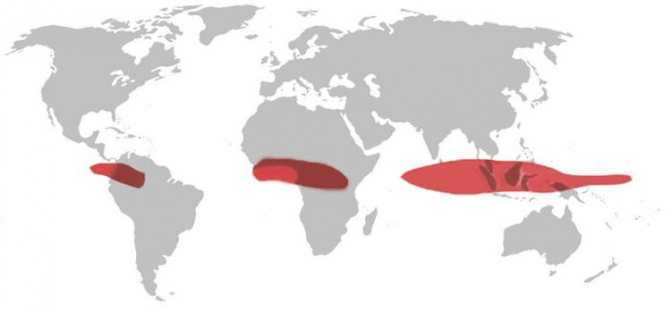
The equatorial zone is home to a total of 11 countries:
- Somalia;
- Sao Tome and Principe;
- Colombia;
- Gabon;
- Ecuador;
- Kenya;
- Republic of the Congo;
- Indonesia;
- Democratic Republic of the Congo;
- Brazil
- Uganda.
In addition to these countries, there are two more states, Kiribati and Maldives, whose maritime borders intersect with the Earth’s equator but do not have any land touching it. The equator’s maximum centrifugal force makes it an ideal location for space missions and the construction of spaceports. For example, the Guiana Space Center was built in the capital of French Guiana.
These types of facilities offer significant benefits, as they allow rockets to gain extra speed by taking advantage of the Earth’s natural rotation, while minimizing the amount of fuel required. This also eliminates the need for resource-intensive maneuvers to compensate for the planet’s tilt during launch.
The imaginary line that runs along the Earth’s surface and divides it into two equal hemispheres is known as the equator. The term “equator” has ancient origins, deriving from the Latin word “aequator” meaning “equalizer,” which itself is formed from the verb “aequō” meaning “to equalize.” The term “equator” entered international usage through the German word “Äquator.”
This term also has a broader definition. In the field of geometry, a three-dimensional object that has both mutually perpendicular axes and a symmetry plane is said to have its equator. The equator is the longest parallel that can be formed by the intersection of the surface of this object with its symmetry plane. In the realm of astronomy, we are familiar with concepts such as the celestial equator and the magnetic equator of a planet or star.
The equator line is depicted on a world map. It is commonly believed that our planet has a spherical shape with an average radius of 6371.3 km. However, this representation is not entirely accurate and does not always lend itself to precise calculations. According to scientific concepts and measurements, the Earth is not a perfect sphere; instead, its shape is described as a geoid or ellipsoid by experts in the field.
The non-spherical nature of our planet was first discovered in the 17th century by Isaac Newton and Christian Huygens. As a result of its rotation on its axis, the Earth is not a perfect sphere but rather takes on a flattened shape. This is due to the centrifugal force generated by the rotation, which is highest at the equator and decreases towards the poles. As a result, the polar radius of the Earth is 21.38 kilometers smaller than the equatorial radius.
An interesting fact about the Earth’s geography is the Congo River, which is located in Central Africa. It is the fullest and second longest river on the continent. However, what makes it truly unique is that it is the only river in the world that crosses the equator twice. This is because the equator represents the latitude at which the Earth’s rotation speed is at its highest. This can be easily explained by the Earth’s maximum radius occurring at the equator. Therefore, the length of the equator is 40,075 kilometers.
km, and by dividing this value by 24 hours (the length of time it takes for the Earth to complete one rotation), we can determine the rotation speed of the Earth at the equator. At zero latitude, the rotation speed is approximately 1670 km/h. As we move closer to the poles, the rotation speed decreases.
Zero latitude
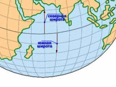
The coordinate grid that covers the globe, which is a visual representation of the Earth, is composed of 360 meridians that connect the North and South poles, and 180 lines that run parallel to the equator. These lines are distributed 90 degrees from the poles, both north and south. The meridian that passes through the Greenwich Observatory, located southeast of London, England, has been used as the reference point for longitude since 1884. The equator, the longest parallel that divides the Earth into the Northern and Southern hemispheres, serves as the reference point for latitude.
Angular quantities called coordinates are measured in degrees. Longitude is the angular difference between the plane passing through the zero – Greenwich – meridian and the plane marked by the line connecting the Earth’s poles and passing through a given point. If a point is east of Greenwich, it is considered to have positive values and is called eastern, while if it is west, it has negative values and is called western.
The equatorial plane is formed by points equidistant from the poles. The angle between the radius drawn from the center of the globe to a specific point on its surface and this plane is called latitude. The longest parallel has a latitude of zero. In the northern hemisphere, this angle is considered positive, ranging from 0° to 90°, while in the southern hemisphere it is considered negative.
Countries situated on the equator
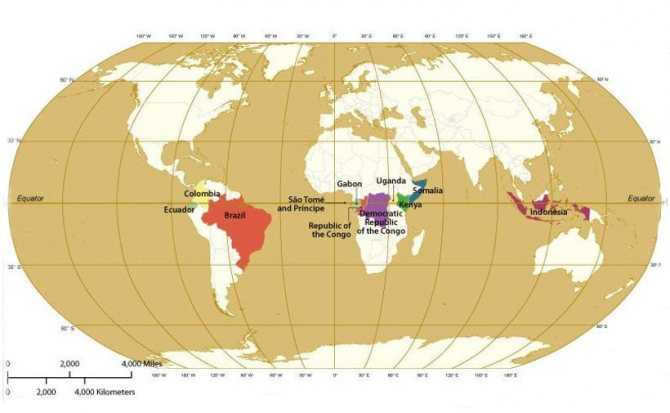
There are a total of 11 countries along the equator. Starting from the Prime Meridian and moving eastward, the countries located at zero latitude are:
- São Tomé and Principe;
- Gabon;
- Republic of the Congo;
- Democratic Republic of the Congo;
- Uganda;
- Kenya;
- Somalia;
- Indonesia;
- Ecuador;
- Colombia;
- Brazil.
In addition, there are two countries whose territorial sea is crossed by the equator, even though it does not directly touch their land:
The prime meridian is the optimal launch site for space missions, and therefore for the establishment of spaceports, such as the Guiana Space Center, situated in the capital city of French Guiana. These launch sites gain a significant advantage by harnessing the Earth’s natural rotation – the extra velocity diminishes the amount of fuel needed to propel the vehicle eastward (in the direction of the planet’s rotation) into orbit, thus circumventing costly maneuvers that would otherwise be required to correct the inclination during liftoff.
The climate at the equator
The equatorial climate zone can be observed on the map of the world. The changing seasons are a result of the Earth’s axis tilting with respect to its orbit around the Sun. As the Earth rotates, different parts of both hemispheres are either closer or farther away from the Sun, depending on the Earth’s orbital position. The hemisphere that is currently tilted closer to the Sun receives more solar radiation, resulting in the summer season. On the other hand, the hemisphere that is tilted farther away from the Sun receives less solar radiation, leading to the winter season.
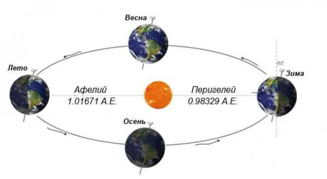
The Earth’s revolution around the Sun
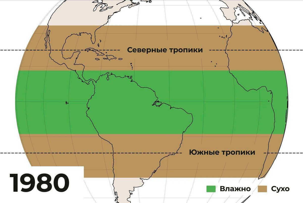
Areas situated at the equator generally experience a tropical rainforest climate, also referred to as an equatorial climate. Despite the presence of cold currents, certain regions have a tropical monsoon climate with a dry season in the middle of the year. Additionally, the Somali current, which is influenced by the East Asian monsoon, results in an extremely dry climate on the Somali Peninsula, even though it is located at the equator.
Fascinating fact: several countries have derived their names from the term “equator,” including Ecuador, Equatorial Guinea, and Equatorial Africa.
The equatorial lowlands experience average annual temperatures of approximately 31°C in the afternoon and 23°C at sunrise. In comparison to regions further from the equator, the amount of rainfall in these lowlands is significantly higher, ranging between 2,500 and 3,500 mm. There are roughly 200 days of rain each year, while the average number of sunshine hours annually is about 2000. Despite the consistently high temperatures, certain elevated regions such as the Andes and Mount Kilimanjaro have glaciers. The southern slopes of Cayambe Volcano, reaching a summit of 5,790 meters, stand as the highest point, with an altitude of 4,690 meters. This particular location along the equator is the sole area where snow can be found on the earth’s surface.
As you travel in any direction away from the equator, the level of solar radiation diminishes, leading to the creation of different climatic zones. However, the equatorial zone is known for its stable weather conditions throughout the year, which has resulted in an unparalleled diversity of flora and fauna. The forests in this region are often referred to as the “lungs of the Earth” as they are responsible for producing the oxygen that sustains all living organisms.
How long is the equator?
Attempts to determine the length of the equator have been made since ancient times. The first person to estimate the length of this imaginary line was the ancient Greek mathematician Eratosthenes in the 3rd century BC.
To accomplish this, Eratosthenes had to measure the time it took for the Sun’s rays to reach a well in his yard and then calculate the radius of the Earth and, consequently, the length of the equator. According to his calculations, the equatorial line was approximately 39,690 kilometers long, which is very close to the modern value with a small margin of error.

The international organizations IAU and IUGG have recognized the actual length of the equator to be 40,075.696 km, with a margin of error of 3 meters. This margin represents the uncertainty in the average radius of the planet.
Equator, longitude, and latitude
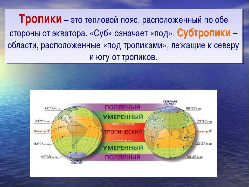
The equator, longitude, and latitude are designated as latitude equals 0° by definition. The equator is one of the five latitudes that are critical to navigation and are generally accepted by the geographic community. The other four latitudes are:
- Arctic Circle;
- South Polar Circle;
- the Tropic of Cancer;
- Tropic of Capricorn.
Zero latitude can be considered the only line that falls under the definition of a great circle.
The great circle, in turn, is any circle that passes along the surface of the globe, dividing it in the center. Thus, the equator line runs along the center of the planet, dividing it into two equal halves. Other latitudes cannot be called a great circle because they, due to their proximity to the poles, divide the circle into unequal parts.
Great circles can also be referred to as parallels, as they meet the definition. However, it is important to consider that the Earth is shaped like an ellipsoid, so the length of any parallel is shorter than the equator, resulting in smaller halves.
Fascinating fact: Brazil is home to a city called Macapa, which is situated in two hemispheres simultaneously. At the heart of the city lies a soccer stadium called Estadio Milton Correa. The center field line of this stadium aligns almost perfectly with the equator. Nearby, you can find the Marco Zero monument.
Areas located on the equator experience the shortest durations of sunrises and sunsets. This phenomenon occurs because the Sun’s daily path is nearly perpendicular to the horizon for most of the year. The length of daylight hours, from sunrise to sunset, remains relatively constant throughout the year, with daytime being about 14 minutes longer than nighttime due to atmospheric refraction and the consideration of sunrise occurring when the top of the solar disk touches the horizon, rather than the center.
Interesting fact: Learn about atmospheric pressure, including its definition, causes of formation, units of measurement, norms, and view photos and videos.
What is the equator, where does it lie, how long is it, and why did scientists invent this imaginary line? We will delve into these topics in great detail.
Definition
The equator is an imaginary line that runs directly through the center of the Earth. Geographically speaking, the equator is located at 0 degrees latitude. It serves as a point of reference for scientists to conduct various calculations, which will be discussed later. The equator divides the globe into two equal parts.
[stop]Important! In the regions where the equator passes, day and night are always of equal length, without any deviation, not even a fraction of a second.[/stop].
The equatorial region receives the most intense amount of ultraviolet rays. As a result, the further away from the imaginary line a point is, the less heat and light it receives. This is why the highest temperature readings have been recorded in close proximity to the imaginary line.
Objective
To perform different calculations, scientists require special markers on the Earth’s surface, known as the equator, parallels, and meridians.
These imaginary lines enable the determination of the location of different objects and aid airplanes in navigation through the skies and ships on the water.
Furthermore, these lines also assist scientists in dividing the entire planet into climatic zones or belts.
Essentially, the Earth’s circumference along the equator serves as a crucial metric parameter that is considered in various fields, including geodesy, basic geography, astrology, and astronomy.
Currently, there are fourteen states that lie on the equator. The political landscape of the world is in a constant state of flux, with countries emerging and disappearing, and their borders expanding and shrinking. So, which specific states are located on the equator?
What is the circumference of the Earth at the equator?
Based on the most accurate calculations, the equator has a length of 40075 kilometers. However, when measured in miles, the length of the Earth’s equator is approximately 24901 miles.
When it comes to the concept of radius, there are both polar and equatorial measurements. The polar radius is approximately 6356 kilometers, while the equatorial radius measures around 6378 kilometers.
Engaging trivia
The regions situated in close proximity to this imaginary line experience a warm and humid climate.
It is no coincidence that life thrives in these areas. This is where you can find the highest concentration of plant and animal species.
Equatorial forests are renowned for their density, with some being so thick that they are virtually impenetrable, despite all the advancements in modern science.
Precipitation is a daily occurrence in the equatorial zone, and it is frequently abundant. As a result, everything in this region is vibrant and displays a wide array of colors.
[warning]Attention! The average yearly temperature in this specific area reaches 25-30 degrees Celsius.[/warning].
Constant high temperatures throughout the year make this region a perfect destination for tourists. This is particularly true for the renowned resorts situated in the Maldives, which attract millions of vacationers from all over the globe annually.
[stop].Crucial information! A glacier can be found at the equator. It is situated at an elevation of 4690 meters on the slope of a volcano known as Kayambe.[/stop].

This is an incredible location, particularly for astronauts. It is fascinating to note that the Earth’s rotational speed along this imaginary line exceeds 460 meters per second.
At the same time, the speed of sound only reaches 330 meters per second. Therefore, any spacecraft launched from this point are essentially starting at supersonic speeds.
We have provided you with information about the equator’s length and its significance in modern human life. Interestingly, there are three countries named after it.
Without this conventional line, there would be no means for individuals to determine the precise location of an island or even a renowned city. or even a well-known city. All aircraft and vessels are oriented on the conventional map of latitudes and longitudes, where the pivotal role is played by the line that bisects the Earth.
The river known as the Congo intersects the Earth’s central line twice.
What is the equator and what are its characteristics?
Determine the circumference of the Earth’s equator


