 Understanding the Night Sky Map
Throughout history, humanity has marveled at the vast expanse of the night sky, adorned with countless sparkling stars. It is believed that even early astronomers, in their quest to comprehend the celestial wonders, discovered that most stars form distinct groups that appear to shift and occasionally disappear beyond the horizon, only to reappear in their familiar positions. These groups acquired unique names, often inspired by animals, mythical creatures, legendary heroes, and even everyday objects.
Diverse civilizations have developed distinct systems for naming celestial formations. For instance, ancient Chinese scientists referred to star clusters based on the names of imperial palaces and their respective rooms. However, the familiar names of the 48 constellations that can be seen in the night sky of the Northern Hemisphere are primarily attributed to the ancient cultures of Europe and the Middle East. Another 40 star groups have been identified since the 16th century. Nevertheless, most of them are only visible in the Southern Hemisphere, hence the ancient Greeks, Romans, and Arabs were unaware of them.
As of today, the celestial sphere recognized by the International Astronomical Union encompasses a total of 88 constellations.
Requirements for observing the night sky
To witness the magnificence of the nocturnal celestial landscape, it is recommended to patiently await optimal conditions for observation:
- The night should be devoid of excessive light pollution and unobstructed by clouds.
- Avoid areas illuminated by artificial lights emanating from nearby urban or rural settlements.
- Preferably position oneself in elevated locations such as mountains, where human habitation is sparse, the air is purer, and the atmospheric density is lower compared to sea level.
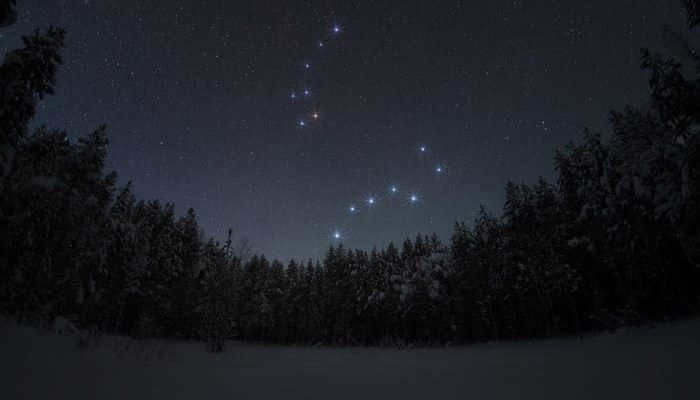
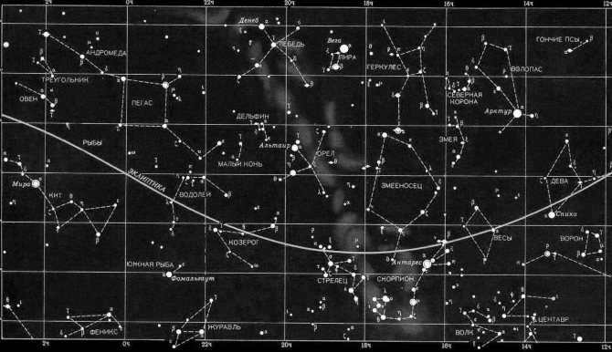
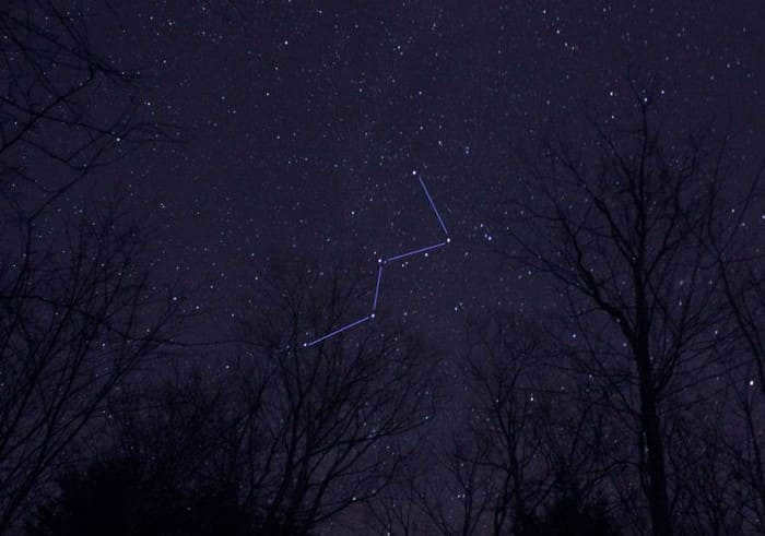
One of the most well-known and easily identifiable constellations in the Northern Hemisphere is the Big Dipper, along with Cassiopeia. The arrangement of stars in Cassiopeia forms a shape that resembles either the letter “M” or “W,” depending on its position in the sky. This constellation represents the unhappy wife of King Cepheus of Ethiopia and the mother of Andromeda, sitting on her throne and raising her hands in a pleading gesture. (The bright band of light that runs through this constellation is actually the Milky Way, our own galaxy, which appears in the sky as a straight line.) On the other hand, the seven bright stars of the Big Dipper create a distinct shape of a dipper, which is easily identifiable regardless of its orientation in the sky. These larger constellations are often divided into different sections, such as the actual ladle and the handle of the ladle in the case of the Big Dipper.
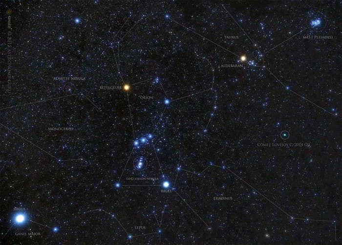
Identifying the constellation Orion, the Celestial Hunter is also quite simple: its Belt consists of three stars arranged in a small slanted line; by using them as a reference point, one can then explore the neighboring constellations. For instance, the horned one The head of Taurus takes the form of a "V" that points directly towards Orion. Not too far from Taurus (although not visible in the figure due to being beyond the horizon) lies the Big Dog with Sirius – the brightest star in the Northern Hemisphere. The constellation Gemini, located to the northwest of Orion, is comprised of two nearly parallel lines that culminate in a pair of luminous stars, Castor and Pollux.
Even in the present day, in numerous nations across the globe, individuals involved in farming rely on the well-known constellations to determine the optimal time for planting, irrigating, or reaping. These clusters of stars are essential for navigating the skies; they also hold great significance for astronomical investigations as they serve as reference points for measuring the position of the celestial object being studied.
For a long time, it has been common knowledge that the stars that make up a single constellation are actually located at various distances from the Earth. The concept of the “celestial sphere” is used to represent this idea. Celestial sphere is a term used to describe the imaginary sphere that all objects visible to the naked eye or telescopes are considered to be connected to. To better understand this concept, imagine an axis passing through the North and South Poles of the Earth, mentally connecting them to the celestial sphere. These connection points are known as the North and South Poles of the world.
How to locate Polaris in the celestial sky
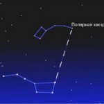
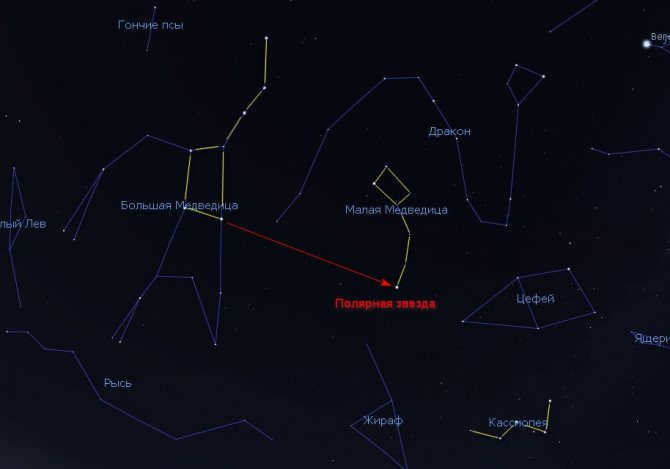
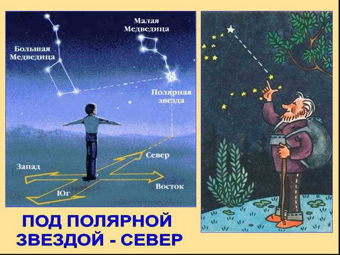
Finding the North Pole in the world is a straightforward task: it can be identified by a luminous Polaris, which our predecessors referred to as “Kol” due to its stationary position in the sky. Locating Polaris is also a simple process – all that is required is to mentally draw a line connecting the two stars of the Big Dipper’s ladle (situated on the opposite side of its handle). When drawn from the bottom to the top, or from the narrowing to the widening of the dipper, this line will lead to a prominent star at the very “tail” of the Ursa Minor constellation.
Constellations in the Northern Circumpolar Region
Similar to the Moon, the constellations move from east to west across the night sky because of the Earth’s rotation on its axis. The constellations found within 40 degrees of the North Pole are part of the North Subpolar Region, and they are always visible throughout the year, never disappearing below the horizon. The five main circumpolar constellations are Cassiopeia, Cepheus, the Big Dipper, the Little Dipper, and the Dragon. The Dragon is a group of stars that form a broken chain and span a large area of the sky. Its tail is situated between Polaris and the Big Dipper, the body curves around the Little Dipper and Cepheus, and the head points towards the constellation Hercules.
Changes in the Night Sky Throughout the Year
Throughout the 365 days that it takes for the Earth to complete a full revolution around the Sun, there are noticeable changes in the appearance of the starry night sky. These changes are a result of the Earth’s movement along its orbit and the tilt of its axis, which determine which parts of the sky are visible to us at different times of the year. For instance, while the constellations of spring become visible above the horizon, the constellations of fall remain hidden from observers for several months.
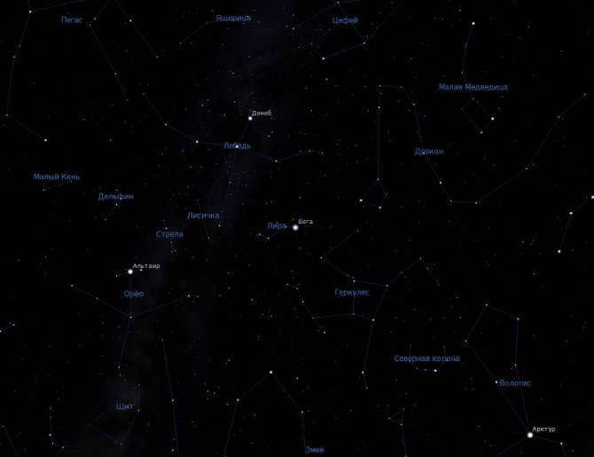
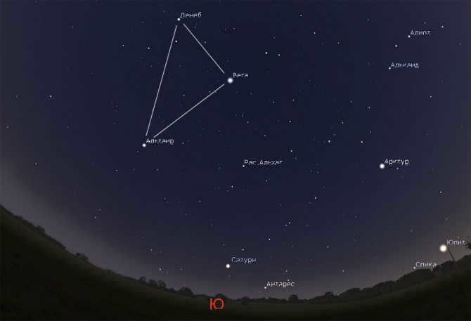
The triangular formation of stars visible in the night sky during warm summer nights in the Northern Hemisphere is known as the Summer Triangle. It consists of the three brightest stars in the constellations of Lyra, Cygnus, and Aquila: Vega, Deneb, and Altair.
Triangle of Winter Stars in the Northern Hemisphere
During the winter season, the night sky in the Northern Hemisphere displays a fascinating celestial formation known as The Winter Triangle. This triangle is comprised of the most brilliant stars in the Orion constellation, namely Betelgeuse, as well as the brightest stars in the Big Dog and Lesser Dog constellations, which are Sirius and Procyon respectively.
In addition to these remarkable stars, other constellations such as Leo and Virgo also showcase dazzling celestial objects. These particular constellations are best observed during the spring season. On the other hand, certain constellations that are not part of the circumpolar region can sometimes be completely concealed behind the horizon. However, they become partially visible when located south of the equator. Some of these constellations include Orion, Taurus, the Big Dog, and Gemini.

Posted in the field of Natural History, this article has been saved for future reference.
Occasionally, it’s pleasant to sit in the evenings and gaze up at the magnificent starry sky. Brilliant specks are interchanged with smaller, fainter ones, while others descend, granting the opportunity to make a wish. Only a few individuals ponder over the fact that many centuries ago, scientists from all corners of the globe devised various theories and practiced astronomy in order to draw nearer to the enigmatic cosmos, to acquire knowledge on how to navigate through the stars. Astounding celestial entities revealed not only the secrets of the universe, but also served as a gateway to a new realm of astonishing discoveries and global exploration, illuminating the correct path for great explorers. So, what exactly is this nocturnal expanse? What mysteries does a star compass hold, and can it truly guide a person who has been searching for a way back home for an extended period of time?
How to Use the Stars for Navigation
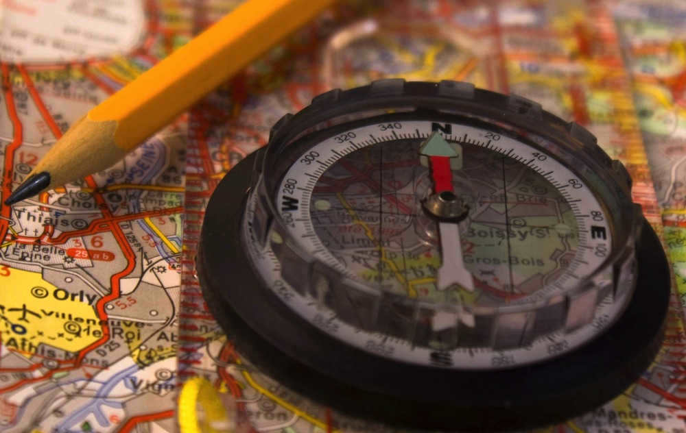
If the evening and night are quickly approaching, and you find yourself outdoors without a way to quickly get home, it may be wise to find a safe place to spend the night. While the easiest way to navigate is with a map, compass, or GPS navigator, you may not have these tools readily available. In such a situation, knowing how to navigate by the stars can be very useful. It is essential to have a clear, cloudless night sky. Celestial bodies always follow the same path, and understanding this can help you navigate using the stars more effectively.
The technique employed in the northern hemisphere
In order to navigate at night, it is essential for travelers to possess an understanding of the positions of various celestial bodies as well as prominent natural indicators pointing north and south. Different systems are utilized in each hemisphere, rendering them ineffective in the opposite hemisphere. Hence, it is impossible to pinpoint the exact star by which sailors relied upon during their fabled expeditions.
Orientation using the North Star and a map
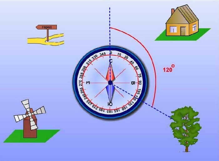
Take note! Once you have found the map and followed the given directions precisely, you can proceed with your journey. In case you need to veer off from the given path, and if you have a compass in your pocket, you can determine the azimuth and follow it, making sure to periodically verify that you are on the right track.
Southern Hemisphere
To avoid losing your way and accurately determining the direction in the Southern Hemisphere, it is important to use the Cross as a guide, pointing directly to the south. This constellation is made up of five distinct and bright celestial lights. Towards the bottom left is the Coal Sack, an area where visibility is limited, and nearby are two prominent stars of the Centaurus constellation.
To establish the direction towards the South, one must envision an imaginary straight line connecting the two farthest stars. Locate the point on this resulting segment. To accomplish this, connect all the points from the Centaurus constellation and visualize a perpendicular line. The intersection of these two lines is the location of the South Pole.
Take note! Occasionally, the Southern Cross can be mistaken for the False Cross. The primary method of distinguishing between the two is to look for Centaurus on the left side. Another differentiating characteristic is the greater distance between celestial bodies in the False Cross.
Simple Observatory
If you have limited knowledge of the night sky and are uncertain about finding Polaris or the Southern Cross, you can still determine the east and west directions. To accomplish this, you can construct a basic observatory and establish an observation point.
Locating the Cardinal Directions Using a Random Star
- If the star is rising, you are facing east.
- If the star is setting, you are facing west.
- If the star is moving in a loop and curving to the right, you are facing north.
- If the star is moving in a loop and curving to the left, you are facing south.
Polaris is not suitable for orienteering purposes, as it remains stationary in the sky. When using this method, be aware that there may be a margin of error of approximately 30 degrees.
What to do when the sky is cloudy?
When it comes to orienteering by the stars on the ground, the weather plays a crucial role. On a clear night, you can easily spot a multitude of twinkling stars. However, if the sky is covered with thick clouds, it can pose a significant challenge for tourists.
In such situations, it is advisable to wait for even the smallest break in the cloud cover and focus on a single visible star. The technique remains the same: insert two sticks into the ground and visually align them with the chosen celestial body.
Important note: The previously discussed methods of using stars for navigation are applicable only in the Northern Hemisphere. In the Southern Hemisphere, their movement is reversed.
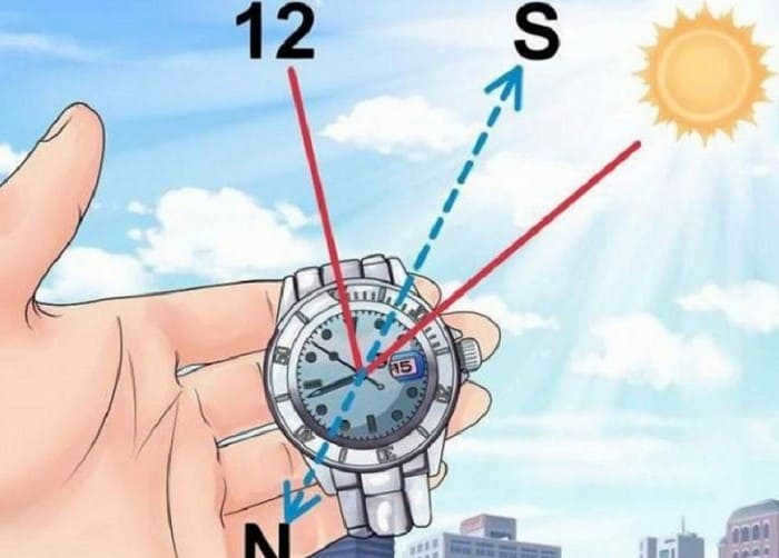
Moon Orientation
The Moon, as a satellite, orbits around the Earth, illuminated by the Sun, but it does not emit light itself. When it reaches its full phase, it is positioned highest above the horizon and located in the southern direction. The shadow cast by objects indicates the north. At 7pm, it can be found in the eastern part of the sky, while at 7am, it can be observed in the western direction.
If the Moon is not fully illuminated, it is necessary to determine its phase. To do this, you can visualize it in the shape of a letter:
- If you imagine the Moon as the letter “R” when it is between the crescent and full phases, it means that it is waxing. At 7pm-8pm, it is positioned in the southern direction, and by 2am, it moves towards the western part of the sky.
- When the Moon resembles the letter “C” in its shape (at 2am, it is in the east and by morning (7am), it moves towards the south), it is in its waning phase.
Determination of latitude
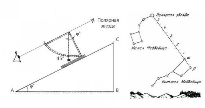
In order to determine latitude, you will require a protractor and a string that is suspended from the center by a weight. The protractor’s base is aligned with the Polaris star, which is located along the Earth’s axis of rotation at a significant distance.
The plumb line is utilized to measure the degrees on the protractor’s scale. The obtained number is then subtracted from 90. The resulting calculation represents the latitude of the specific location where the tourist is situated.
Orienteering using the constellation Orion
The belt of Orion is comprised of the three most luminous stars. Situated on the celestial equator, it provides a reliable means of determining east and west directions, regardless of the observer’s latitude.
Locating the constellation in the night sky is simplest during winter in the Northern Hemisphere and summer in the Southern Hemisphere. The precise direction to the west can be determined by identifying the point at which the belt intersects the horizon at sunset. On the other hand, pinpointing the east can be more challenging as the constellation becomes visible when the belt ascends above the horizon. The point of intersection at sunrise marks the east.
Determining the precise location in the vast ocean is a tremendously challenging task. In the present day, large ships and smaller vessels alike are equipped with cutting-edge navigation systems that calculate the optimal path and provide minute-by-minute updates on any deviations from the intended course.
Nevertheless, history has documented instances of computer viruses infiltrating maritime computer systems, resulting in mariners being stranded at sea for weeks on end, anxiously awaiting the arrival of an IT specialist.
Countless groundbreaking discoveries and epic voyages took place long before the advent of computers on board ships. Vikings and Polynesians, renowned explorers and everyday adventurers alike relied on their expertise in navigating the natural world, using celestial cues and the patterns of the night sky to guide their way.
Discovering the Way: The Ingenious Navigation of Early Seafarers
Centuries before Columbus stumbled upon America, the Polynesians were already traversing the vast expanse of the Pacific Ocean in their sturdy canoes. Their impressive journeys spanned thousands of kilometers as they skillfully navigated between the scattered islands of Polynesia. Their trusty companions on these voyages were the celestial bodies – the sun, stars, moon – as well as the wind and currents, which guided them to their desired destinations.
Moreover, archaeologists have unearthed ancient maps crafted by these seafarers, constructed from shells and sticks. These maps, quite distinct from the conventional ones we are familiar with, offer a unique glimpse into the navigational techniques employed by these early explorers.
The Vikings, too, were no strangers to the challenges of seafaring. They braved the treacherous waters between Northern Europe, America, the British Isles, Iceland, and Greenland. Renowned for their intuition, remarkable attentiveness, and meticulous calculations, the Vikings expertly sailed with the aid of prevailing currents, carefully observing for any signs of marine life, particularly whales, which often indicated the proximity of land. Additionally, each vessel housed a trained raven, dispatched to scout ahead and provide valuable clues about the whereabouts of the shore.
In addition to using a sundial for orientation, the Vikings utilized various methods to find their way at sea. They were able to estimate the ship’s approximate speed, keep track of the number of days spent on the journey, and even relied on the polarization of light to navigate during inclement weather. However, due to the inherent inaccuracies in these calculations, factors such as a lack of wind, fog, and overcast conditions often resulted in the Vikings becoming disoriented and losing their way, giving rise to legendary tales of their navigational struggles.
The Longitude Battle
The concept of coordinates, which enable precise determination of one’s current location, was first introduced in Ancient Greece around 200 BC. Through extensive contemplation, the greatest minds of the time managed to develop a comprehensive understanding of geographic longitude and latitude by 100-160 years AD.
Claudius Ptolemy emerged as the pioneer of this theory. His groundbreaking work provided seafarers with the means to approximate their position and make necessary course corrections in a timely manner. However, the calculation of coordinates proved to be more challenging than initially anticipated by the esteemed scientist. While latitude could be easily determined using the Sun, Moon, and other celestial bodies, calculating longitude posed significant difficulties.
To accomplish this task, it was essential to compute the disparity between the current position’s time and an imaginary point’s time at the same instance. Initially, seafarers encountered challenges in ascertaining the precise time at their current location, and it was even more arduous to determine it at another fixed point (which could be the point of departure or the Greenwich meridian). Even rough estimations were inadequate, as a one-degree deviation in longitude at the equator equated to 110 kilometers.
How fascinating! The predicament of determining the time at the second fixed point remained an insoluble quandary for such a prolonged period that Louis XVI blamed the French astronomers for their subpar work. He believed that they were responsible for the string of unsuccessful attempts to discover new lands.
Starting from the sixteenth century, the dominant maritime powers such as Spain, Holland, Portugal, Italy, and England were all vying to develop the most accurate and reliable method for determining longitude. This led to a fierce competition among them. The English government even announced a grand prize of 20 thousand sterling for the person who could achieve this feat. In the eighteenth century, a watchmaker named John Harrison introduced his remarkable creation – the chronometer, and he was awarded the majority of the prize money.
During the same period, another important device called the sextant was invented. This device, which utilized the sun for orientation, was a collaborative effort by several renowned scientists including Isaac Newton, John Headley, and Thomas Godfrey.
What we have at present
In the present day, sailors are relieved from the burden of complex calculations, thanks to the installation of automatic navigation systems on board their vessels. This advancement allows sailors to dedicate more attention towards the examination of their surroundings, including weather conditions, the ship’s speed, and the relief of the ocean floor. Occasionally, crucial decisions are made based on these observations. The computerization and autonomous functionality of these systems contribute to the overall safety of navigation.
The most widely utilized navigation system nowadays is the Electronic Chart Display and Information System (ECDIS). When a ship opts for electronic charts instead of traditional paper charts, a minimum of two independent computers and separate displays are installed to ensure redundancy and reliability.
What happens in the event of a sudden breakdown?
Simply duplicating the navigation system does not provide a guarantee that the computers will never malfunction or fail. There are numerous factors that can contribute to this, ranging from system requirements for map updates to potential hacker attacks. As the system is used, sailors are able to identify the weakest and most vulnerable points. Developers then work to address and correct these issues, constantly striving to create something new and more reliable.
In the event of a system failure, the consequences are not as severe if the ship is in close proximity to the shore or within a strait. The captain can request a map of the area from the shore, complete with precise coordinates for any “dangerous” zones, and sailors can rely on their smartphones for navigation. Additionally, landmarks can still be identified visually. However, if the navigation systems were to fail in the middle of the open sea, far from any shore, the crew would undoubtedly face significant challenges.
The GPS system is not infallible; it can be prone to electromagnetic disturbances and even manipulated by malicious individuals. These individuals can obtain a device that disrupts communication between the GPS and the traveler’s device, throwing the ship off course. Despite the ship’s sensors indicating normal readings on the dashboard, it can still be hijacked and redirected towards an unknown destination.
To avoid such dire situations in the vast open sea, various academic institutions around the world continue to educate cadets on ancient methods of celestial navigation. By relying on the stars, the Sun, and the Moon, mariners can navigate their ships with greater accuracy and reduce the risk of catastrophic mistakes. Without this knowledge, a ship may unknowingly collide with treacherous reefs or become stranded on shallow grounds.
Nevertheless, it can be quite challenging for a vessel to become disoriented amidst a multitude of maritime passages – sooner or later, another vessel will emerge on the horizon and summon a search and rescue team for assistance.
It is feasible to become disoriented in nearly any location. The key is to remain calm and recall all the natural indicators that can help one navigate the terrain, not only during daylight hours using the sun, but also at night using the celestial stars.
Orienteering
When embarking on a journey, contemporary travelers often bring along a plethora of gadgets to assist with determining their location. However, these navigational devices are not designed to function without communication in remote wilderness areas and can malfunction at the most inconvenient times, especially at night. In such instances, one must rely solely on their own abilities, which is why it is crucial to familiarize oneself with the various methods of navigating by the stars before embarking on a hiking adventure.
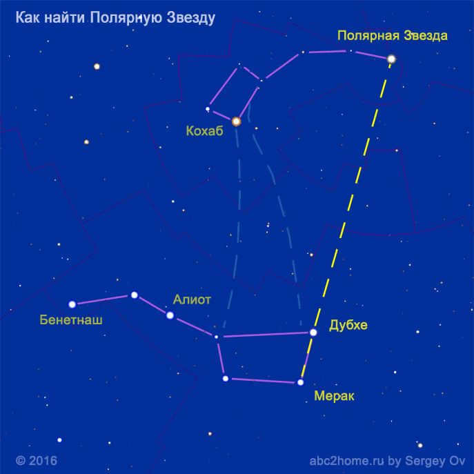
The definition of Polaris is considered an easy way to orient by the celestial luminaries. Not only is it one of the brightest, but it also remains in a fixed location. There are two known methods that can be used to accurately locate Polaris.

Locating the Constellations of Ursa Major and Ursa Minor
These particular constellations are famously known as the Big Dipper and Little Dipper. To identify the main reference point using the stars, follow these steps:
- Visually connect the outermost stars of the bowl-shaped section of the Big Dipper.
- Extend the imaginary line towards the outermost star on the handle of the Little Dipper.
- If the distance between the constellations is equivalent to five times the size of the bowl-shaped section of the Big Dipper, then the reference point is accurately determined.
Polaris, also known as the North Star, serves as the reference point to the north. Consequently, when facing Polaris, one will be looking towards the south.
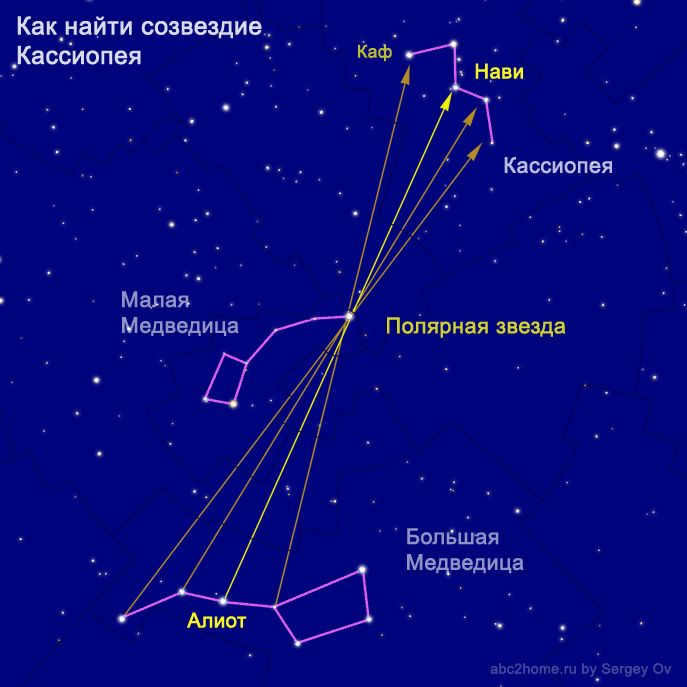
Cassiopeia
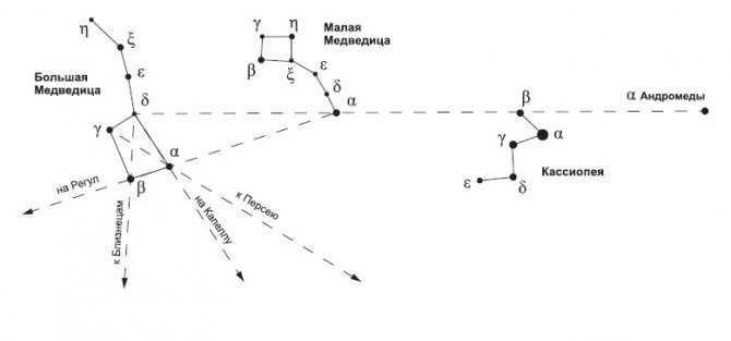
During the nighttime, it is quite easy to observe the constellation Cassiopeia, which is symbolized by the letter W. Polaris can be spotted along the line that connects the lower left point of the letter W with the second star on the handle of the Big Dipper. This reference point will be situated roughly in the middle of the line where it intersects with the Little Dipper.

 The star constellations known as the Big and Little Bears are a fascinating sight in the night sky. These constellations can be easily found in the northern hemisphere and are a popular subject for stargazers and astronomers alike. They are easily recognizable and have been a part of human culture and mythology for centuries. In addition to the Big and Little Bears, another notable constellation in the northern hemisphere is Cassiopeia. Cassiopeia is named after a queen from Greek mythology and is often depicted as a seated woman in the sky. These constellations provide a beautiful and awe-inspiring view of the cosmos and are a reminder of the vastness and wonder of the universe.
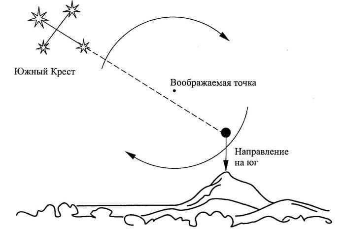
When you find yourself in the southern part of the world, you have a reliable guide in the form of the Southern Cross constellation. Unlike the well-known Polaris, which is not visible in this hemisphere, the Southern Cross is a prominent feature of the night sky.
This constellation is made up of four brilliant stars that form a distinctive cross shape. It is crucial to distinguish the Southern Cross from the False Cross, which can be found to the right. The stars in the False Cross are not as bright and are spaced further apart.
To determine the southern direction using the Southern Cross, you simply need to mentally draw a line connecting two stars that are opposite each other. This line should intersect with another imaginary line, forming a cross. The longer of the two lines indicates the direction of the south.
Take note! In the event that the traveler has some spare time, they should patiently wait for the instance when the fictitious queue within the constellation aligns perpendicularly with the sky. At that point, by simply observing the Southern Cross, the precise direction to the south can be determined.

Orienteering using the constellation Orion
The constellation Orion is visible from any location on Earth, making it a useful tool for determining direction in both the northern and southern hemispheres. However, this method is most effective during the winter season.
Orion is composed of seven stars and has a distinctive hourglass shape. The three stars in the center, known as Orion’s Belt, play a key role in orienteering. At sunrise, the rightmost star of the Belt points towards the east, while at sunset it points towards the west.
Determining latitude
Experienced travelers can determine their location’s latitude even at night, thanks to the celestial bodies. To accomplish this, they must:
- Locate Polaris.
- They can use any method to find it, such as observing the constellations of Ursa Major or Cassiopeia.
- Measure the angle between Polaris and the horizon.
There are two possible scenarios in this case:
- To precisely determine the number of degrees in this angle, it is recommended to use specialized devices. By using a quadrant or a sextant, one can determine the angle that appears on the curved surface of the instrument. The obtained angle is equivalent to the latitude north of the equator.
Constellations’ Positions
Tourists who possess knowledge of constellations can effectively determine directions and navigate their way, especially on a cloudless night. Hence, it is crucial for newcomers to comprehend how the stars shift their positions throughout the night and across the calendar year. Specific times of the year are more conducive to identifying various constellations.
| Time of year | Month | Constellations |
| Spring | March | Cancer, Kiel, Compass, Leo, Flying Fish, Lynx |
| April | Great Bear, Chameleon, Bowl, Hydra, Little Lion. | |
| May | Southern Cross, Hound Dogs, Centaurus, Virgo, Magus, Wolopassus | |
| Summer | June | Little Bear, Libra, Wolf |
| July | Northern Crown, Dragon, Hercules, Scorpio, Southern Triangle, Snake, Serpent, Serpentine. | |
| August | Southern Crown, Lyra, Sagittarius, Shield, Telescope | |
| Autumn | September | Eagle, Capricorn, Swan, Dolphin, Lesser Horse, Indian |
| October | Aquarius, Cepheus, Crane, Pegasus, Southern Fish | |
| November | Cassiopeia, Andromeda, Phoenix, Pisces, Tucan, Taurus. | |
| Winter | December | Orion, Aries, Eridanus, Furnace, Clock, Southern Hydra, Perseus, Triangle |
| January | Small Dog, Goldfish, Table Mountain | |
| February | Big Dog, Ascendant, Giraffe, Dove, Gemini, Hare, Painter, Unicorn. |
Did you know? Memorizing all constellations at once can be challenging, but it’s not necessary. Instead, focus on identifying key constellations like the Great and Little Dog, Leo the Lion, the Wolopassus, Taurus, and Orion to locate the south at midnight. Additionally, the Milky Way, which stretches from the south to the north, can serve as a helpful reference point.
The versatile peg method
Daytime navigation
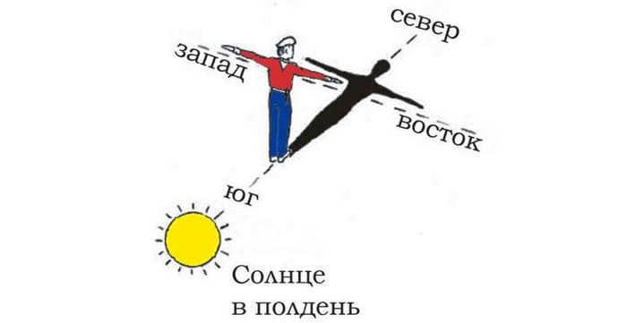
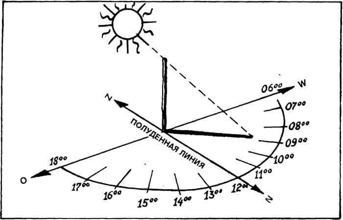
Navigating through the landscape can also be accomplished using the Sun. This is a reliable point of reference that maintains a consistent path throughout the day. Additionally, unfavorable weather conditions rarely obstruct the view of this celestial body.
There are two fundamental principles for the orienteer who relies on the position of the Sun during their journey. Firstly, if the traveler is in the southern hemisphere, they can determine the north by looking at the Sun at noon. Conversely, in the northern hemisphere, south can be identified during this time. Secondly, the east marks the beginning of sunrise, while the west signifies the start of sunset.

The procedure for orientation using pegs is as follows:
- First, a long stick or peg should be driven into the ground, preferably on a flat surface, in order to create a distinct shadow.
- Then, the top of the shadow cast by the object is marked.
- A second mark is made at least 30 minutes later, when the shadow will have shifted from its original position.
- By connecting these two points, the east-west direction can be determined. In this case, the first mark indicates the west, while the second mark indicates the east.
- To determine the location of the north, one must stand facing the line connecting the two marks, with the toe of the left foot touching the first mark and the right foot on the second mark. The north is directly ahead, with the north-south direction perpendicular to the drawn line.
How to Navigate When the Sky is Cloudy
There are times when orienteering using the Sun becomes challenging due to unfavorable weather conditions, such as dense black clouds. However, even in such situations, it is still possible to determine the direction of travel by observing the less cloudy parts of the sky. It is important to note that there may be a slight margin of error, ranging from 10 to 20 degrees, in the calculations.
Cloudy weather does not hinder the use of orienteering methods involving stakes, as the clouds do not obstruct the view of the Sun’s shadow. Some adventurers resort to an alternative method of Sun navigation in such cases, which involves the following steps:
- In the morning, mark the upper point of the shadow cast by a peg and measure its length;
- By the afternoon, you should make a second mark at the highest point when the shadow is the same length as the first time.
- Connect the marks with a straight line. This line will indicate the north-south direction.
Nighttime Orienteering
If a traveler is lost in the wilderness, they can plan their route regardless of which continent they are on. For instance, the constellation Orion can be used as a guide in both the northern and southern hemispheres. However, any other star can be chosen to apply the universal method using two markers.

What is the technique for finding direction?
- To begin, stakes are placed one meter apart. The chosen celestial body should be aligned with the stakes.
- Observe the movement of the star for a period of time.
- If the star has risen above the imaginary line between the stakes, it means the line is pointing east. Conversely, if the star has moved slightly downward, it means the line is pointing west.
- Movement to the right indicates the line is pointing south. Movement to the left indicates the line is pointing north.
- However, this method becomes more complex if the displacement of a bright star is at an angle. In that case, more complicated calculations are required, which will take additional time.
Navigation by Celestial Bodies at Sea
It is nearly impracticable to determine the correct course at sea solely by observing the stars. Nowadays, modern ships, including small vessels, are outfitted with satellite navigation systems that operate even in the most isolated regions.
Centuries ago, remarkable voyages and expeditions were accomplished without the aid of satellites and computers. Great explorers and renowned travelers charted precise courses by relying on natural indicators. In the past, the stars, the Sun, the Moon, wind patterns, and ocean currents served as the primary means of navigation in the open sea.
It wasn’t just scientists who ventured across the oceans. The Vikings also embarked on journeys across the globe, relying not only on calculated directions but also on intuition and keen observation.
Just so you know. Ancient sailors also utilized sundials as a point of reference. This allowed them to gauge the speed of their ship and navigate through cloudy weather. However, these calculations were highly imprecise.
In present times, GPS systems on ships are incredibly dependable. However, they are still vulnerable to hacking attacks. That’s why every sailor should be familiar with celestial navigation. By using the stars, one can determine the cardinal directions at sea, depending on the hemisphere. Polaris or the Southern Cross constellation can be particularly useful in this regard.
The ability may be necessary at any given moment. It is crucial to keep in mind that the suggested techniques, without the utilization of specialized devices, come with a margin of error. However, in the event that a traveler finds themselves disoriented, the skill of navigating by the celestial bodies will aid them in staying calm, determining the correct direction, and finding their way out of an unfamiliar location.
Did you find this information helpful? Feel free to share your thoughts in the comments section!
Video about the subject
Hello and welcome, esteemed visitors of our research facility known as Housewife Art! Our team cordially invites you to embark on an enthralling journey through the vast expanse of the cosmos, with a truly remarkable objective: to explore the constellations of the Northern Hemisphere, learn how to locate them in the night sky, identify the planets visible from Earth, and discover their positions overhead… We will elucidate the various constellations and their respective names, both in general and specific terms. Prepare yourself for an engrossing experience and let us venture into the depths of space!
Please ensure you find a comfortable position to avoid any neck stiffness. Rest assured, this expedition promises to be captivating. So, without further ado, let us commence our celestial odyssey!
Allow us to provide you with an overview of the itinerary:
- Explanation of constellations;
- Introduction to the constellations of the Northern Hemisphere;
- Exploration of the celestial objects neighboring the Big Dipper;
- Orion, the most enigmatic constellation;
- Lyra, Swan, and other constellations;
- The Magus, the Northern Crown, Hercules constellations;
What is a constellation
Constellations are groups of stars that the sky is conventionally divided into for easy orientation in various sciences (astronomy, astrology, etc.). Each group forms a unique pattern and occupies its own area in the sky. It’s important to note that the stars within a constellation are not actually related to each other in any way and can occupy different positions in three-dimensional space. They can be far away or closer, or even close or far away from each other. However, from Earth’s perspective, we see them as close objects forming a distinct pattern or group.
Conveniently, the simplification allows for easy memorization of the visually small groups. These groups can then serve as a reference point or guide when encountering different cosmic phenomena.
Each group of stars in the sky has its own unique names. A number of them are derived from mythology, such as Cassiopeia, Ursa Major, Vulpecula, and Andromeda. Other constellations were named more recently and have more modern designations, like Octans, Corona Borealis, and Crux. The zodiacal constellations have been known since ancient times, totaling 88 in total.
Observing the night sky is an activity that has been practiced by humans for a very long time. The sight of stars scattered across the dark expanse of space has always captivated our attention, albeit in different ways throughout history. However, it is quite paradoxical that despite this long history, our knowledge about the stars remains limited. Why do many people today struggle to navigate the night sky and only recognize the Big Dipper and Polaris?
Indeed, due to evident circumstances, individuals residing in urban areas lack the chance to frequently gaze upwards and witness the wonders above. The illumination from city lights renders this task unattainable. However, there exists the possibility of embarking on excursions to rural regions. On nights with clear skies, one can behold a plethora of celestial delights! Let us delve into the constellations that adorn the northern hemisphere and explore which ones are visible after nightfall.
Due to the excessive brightness of street lighting, the act of observing the stars has become increasingly challenging. In urban areas, only the most prominent stars and planets are visible to the naked eye, as well as the Sun and the Moon, of course. Light pollution has caused a significant decrease in the number of individuals who can witness the luminous strip of the Milky Way – the projection of our Galaxy’s disk in the celestial sphere – with approximately 60% of Europeans and nearly 80% of North Americans being affected.
An intriguing incident occurred in Los Angeles in 1994 when a powerful earthquake led to a city-wide power outage. During this blackout, numerous reports were submitted to the police regarding the presence of a peculiar “giant silvery cloud” hovering above the city. Surprisingly, it was later discovered that this cloud was, in fact, the Milky Way, a sight that had long vanished from the bright, grey nocturnal sky of the bustling metropolis….
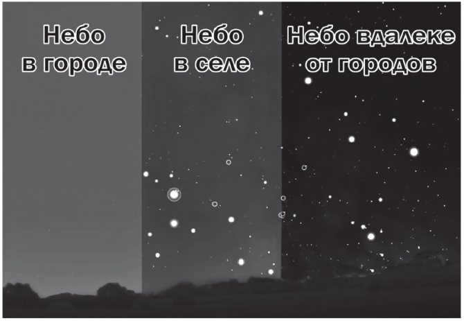
Scale of light pollution of the sky
Constellations in the Northern Hemisphere
Similar to how the Earth is divided into Eastern and Western hemispheres, the night sky can also be divided into two hemispheres – Northern and Southern. There is also an equatorial part. Since we are located in the Northern part, we will focus on that.
The constellations in the Northern Hemisphere are the constellations that can be observed by people living on the Northern side of the equator. People in the Southern Hemisphere cannot see these constellations because the Earth is in a fixed position relative to the other stars in the universe.
There are certain constellations in the northern hemisphere that can always be seen. These constellations are located near the polar star, which serves as a guide to the North Pole. The constellations include the Big and Little Bears, Andromeda, Cassiopeia, the Dragon, Cepheus, Lynx, and the Hounds.
Different constellations become visible throughout the year or disappear below the horizon. During the summer months, one can easily spot constellations such as Perseus, the Northern Crown, Lyra, Veronica’s Hair, the Magpie, and Hercules. On the other hand, during winter, Orion becomes visible, with the bright star Betelgeuse being one of the first to appear in the night sky. However, it’s important to consider the latitude of your location as the northern half of the Earth is quite vast. What one person living in the north sees may differ from what someone in the south sees.
That concludes the theoretical part. Now, let’s move on to the practical aspect of our stargazing journey.
What other ways can one distinguish between a planet and a star?
We must also bear in mind that Venus and Jupiter shine the brightest among all celestial bodies! They are only surpassed in brightness by the Sun and the Moon. Venus, in particular, is exceptionally luminous! It can be easily spotted even during the day, and its radiance creates clearly defined shadows on various objects at night.
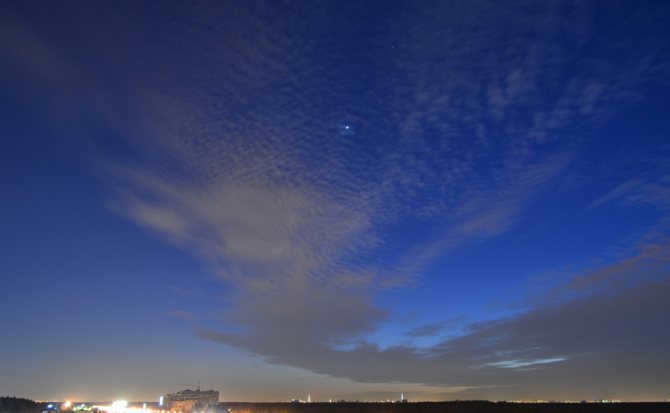
The planet Venus was observed in the sky above St. Petersburg in March 2021. The photograph was taken by Natalia Danilenko.
Although Jupiter is not as radiant as Venus, it is still considerably brighter than the stars. Even Sirius, the brightest star in the night sky, cannot compare to the brilliance of Venus and Jupiter!
The planet Mars can also exhibit significant brightness (even surpassing Jupiter!), but only for a few months during oppositions.
Mercury and Saturn, on the other hand, have a weaker luminosity and are comparable to the brightest stars. Mars, for the most part, appears even more modest – resembling a second magnitude star. These planets cannot be distinguished from stars based solely on their brightness.
We have explored the constellations near the North Pole that can be seen year-round. However, there are many more fascinating celestial wonders to discover in the Northern Hemisphere at night. Let’s delve deeper and admire some additional stunning star clusters.
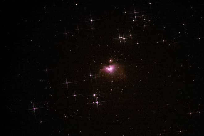
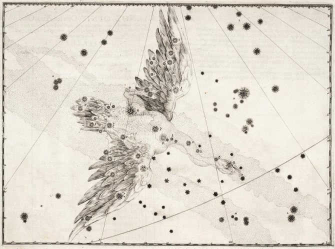
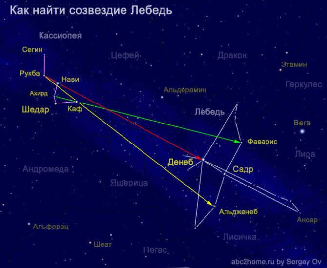
Locating the Andromeda Constellation and Galaxy
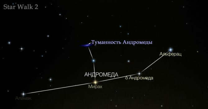
Despite being the closest galaxy to our Milky Way and rapidly approaching us, the Andromeda Nebula appears as a tiny star. It is one of the stars in the Andromeda constellation. While the galaxy itself is barely visible, finding the Andromeda constellation in the night sky is not difficult.
Fascinating! The Andromeda Nebula is the sole galaxy visible to the naked eye in polar and temperate latitudes. Just imagine the vastness of the cosmos!
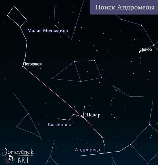
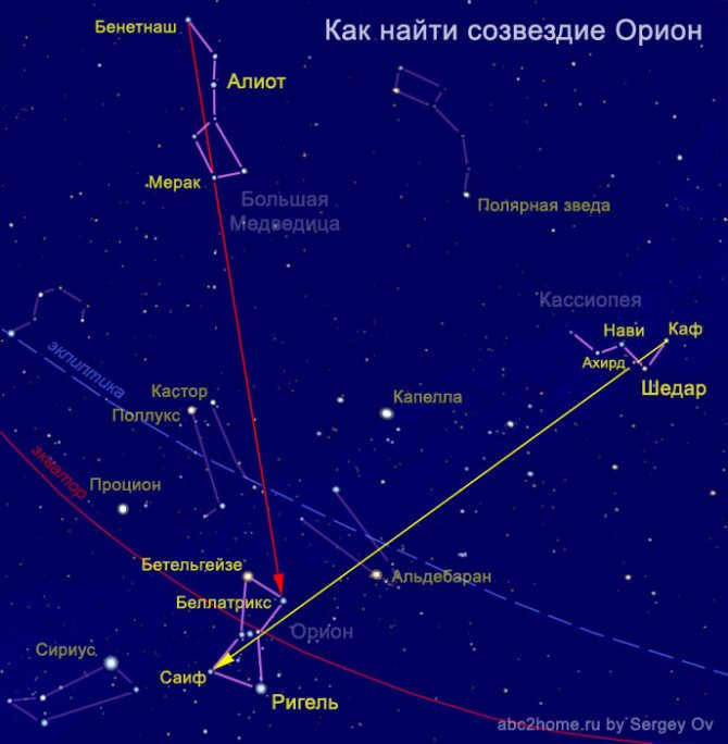
To locate the Andromeda constellation, start by identifying Cassiopeia and Polaris. Then, draw a straight line from Polaris through the star Shedar in Cassiopeia (refer to the image). If you extend the line from Shedar further, approximately halfway between these stars, you will come across a small cloud. This cloud is the Andromeda Nebula galaxy. Furthermore, in close proximity to this cloud, you will find three stars that are part of the Andromeda constellation. It may be helpful to refer to the image for further guidance.
The constellation Perseus in the night sky.
If you gaze just “beneath” the letter M and Andromeda, you will easily locate Perseus, a neighboring constellation to Cassiopeia. During the summer, particularly in August, this constellation is quite prominent and can be seen clearly due to its considerable size.
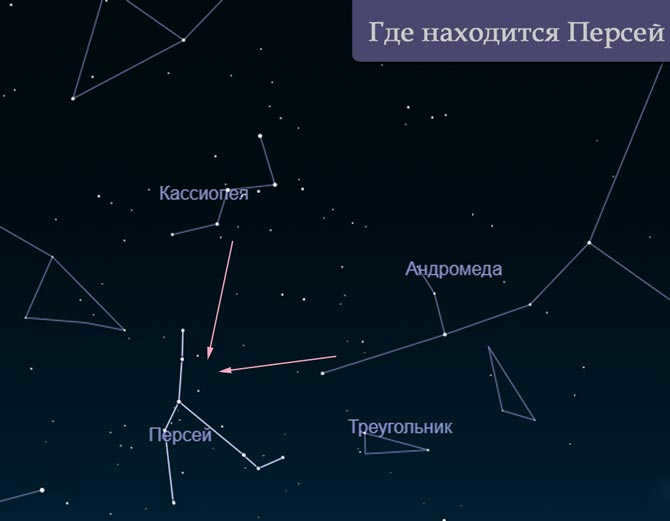
Discovering the enigmatic constellation Orion
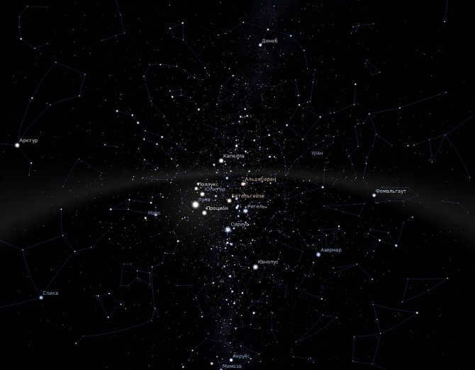
If we shift our gaze towards the lower regions of the night sky, somewhere nestled between the constellations of Perseus and the radiant star Capella, we will come across the enigmatic and captivating constellation Orion. This celestial formation is classified as an equatorial constellation, making it visible from both the northern and southern hemispheres. However, like everything in the universe, the appearance of this mythical hunter is dictated by its own cosmic schedule.
The Orion constellation is most visible during the winter season. Its most luminous star, the red supergiant Betelgeuse, is one of the initial stars that can be spotted in the night sky. If you want to observe Orion during the summer months, you will need to wait until the middle of the night. For instance, in August, around 3-4 am, it becomes noticeable in the southeastern portion of the celestial dome.
And finding the constellation itself is simple thanks to its distinct asterism – Orion’s Belt, which consists of three bright stars in a straight line. And when we expand our view a bit, we can see a recognizable shape resembling an hourglass, formed by the stars Betelgeuse, Bellatrix, Saif, and Rigel.
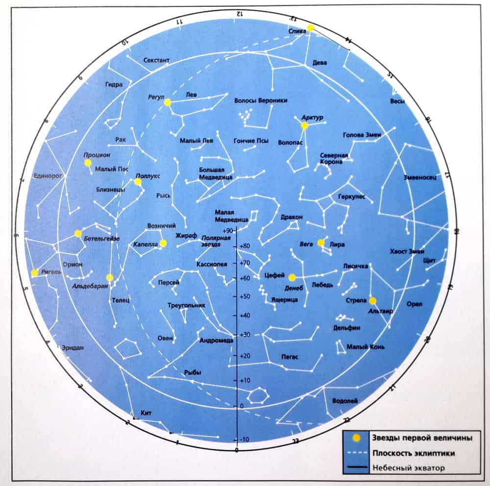
Celestial sphere and star charts
The heavens appear to us as a vast dome, or more accurately, a sphere. In ancient times, it was believed to be a physical, transparent solid sphere (or multiple spheres), and modern astronomers still refer to it as the “celestial sphere,” which is an imaginary sphere onto which all visible celestial objects are projected.
Since ancient Greek times, the scientific community has recognized the division of the sky into constellations. Currently, according to the International Astronomical Union, the sky is divided into 89 regions, each named after one of the 88 constellations (with two regions belonging to the constellation Serpens, divided by the constellation Ophiuchus). Just over half of these constellations have been known since ancient times and are predominantly named after mythological figures. The remaining constellations were discovered between the 16th and 19th centuries.
There are noticeable formations made up of bright stars within certain constellations, while in others, an inexperienced observer may not be able to identify a single star. However, constellations span the entirety of the sky, with not a single area, no matter how small, being excluded from a constellation.
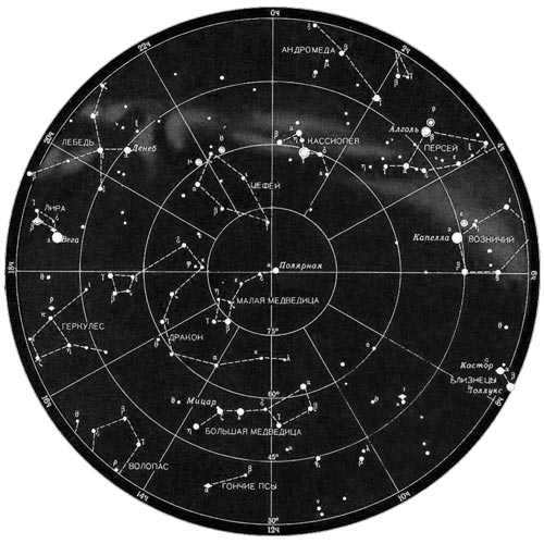
When it comes to observing the sky, amateur astronomers require star maps. These maps come in various formats, with some displaying lines that connect the bright stars within constellations. These maps are specifically designed to assist novice stargazers in navigating the night sky more effectively.
Unlike other maps, these maps do not include these lines. However, they do display the limits of the constellations (i.e., the regions of the celestial sphere they occupy) and celestial coordinates. Additionally, they may depict stars that are fainter than those observable with the naked eye, as well as nebulae, galaxies, and star clusters. These maps are specifically created for observation with a telescope or other optical device.
Map of circumpolar constellations
Observation
Observing and studying the constellations is a fascinating endeavor. Each day, they gradually shift towards the west, while new constellations emerge in the east. Over the span of a year, one can witness all the constellations visible in a particular hemisphere.
In fact, knowledge of the constellations is essential for anyone interested in astronomy. It serves as the foundation, much like the alphabet is to reading or numbers are to math. By familiarizing yourself with the constellations, you can effortlessly locate any celestial object of interest. It is also beneficial to be aware of the brightest stars within these constellations.
To delve into the study of constellations, maps are indispensable. You can make use of these maps or the fantastic free program Stellarium, which is available for both computers and smartphones.

The planets radiate a steady and serene glow while the stars shimmer
Have you ever observed that stars almost always shimmer unevenly? They fluctuate, flare, and fade rapidly, resembling a candle flame in a gust of wind? This occurrence is known as twinkling. Stars twinkle due to variations in the atmosphere through which their light travels. Therefore, the closer a star is to the horizon, the more it twinkles. (When a star is at the horizon, its light passes through the Earth’s denser atmosphere.)
However, the vibrant planets – Venus and Jupiter, Saturn and Mars – hardly twinkle at all! They emit a steady and composed glow, resembling a spotlight. This is the most noticeable and captivating distinction between planets and stars.
So, why don’t planets twinkle?
When we look at stars through a telescope, we see them as tiny dots of light. In contrast, planets are visible as round discs. Each point on the planet’s disc also flickers, growing brighter and then dimmer. This same flickering effect occurs with neighboring points on the disc. If one part of the planet’s disc becomes brighter, another part may become dimmer. As a result, when we add up the light from all points on the disc, we perceive a constant level of brightness.
List of 12 Zodiac Signs
If you were born during the following dates, then you fall under the corresponding zodiac sign:
- Date: March 21 – April 19
- Sign: Aries
- Notable traits: active, demanding, determined, organized, ambitious.
- Date: April 20 – May 20
- Sign: Taurus
- Notable traits: reliable, insightful, appreciative, mentoring, patient
- Date: May 21 – June 20
- Sign: Gemini
- Notable traits: sociable, indecisive, inquisitive, intelligent, fickle
- Date: June 21 – July 22
- Sign: Cancer
- Notable traits: emotional, diplomatic, eccentric, impulsive, selective
- Date: July 23 – August 22
- Sign: Leo
- Notable traits: eager to rule, spirited, generous, loyal, proactive
- Date: August 23 – September 22
- Sign: Virgo
- Characteristics: analytical, practical, reflective, observant, thoughtful.
- Date: September 23 – October 22
- Sign: Libra
- Characteristics: balanced, fair, appreciative of beauty, perfection.
- Date: October 23 – November 21
- Sign: Scorpio
- Personality traits: fickle, willful, determined, unyielding.
- Date: November 22 – December 21
- Sign: Sagittarius
- Characteristics: love philosophy, movement, experimentation, optimist
- Date: December 22 – January 19
- Sign: Capricorn
- Characteristics: determined, bossy, persistent, practical, willful
- Date: January 20 – February 18
- Sign: Aquarius
- Personal qualities: always knowledgeable, humane, serious, shrewd, duplicitous
- Date: February 19 – March 20
- Sign: Pisces
- Personal qualities: hesitant, deep, gifted with a rich imagination, reactive, indecisive
Graphic courtesy of: Pixabay
One simple way to navigate the stars is by locating Polaris. Not only is it one of the brightest, but it remains in a fixed position. There are two known methods to accurately find Polaris.
The configuration of the Ursa Major and Ursa Minor
These arrangements are depicted as a large and small ladle. To establish the primary point of reference using stars, you must follow these steps:
- mentally connect the outermost stars of the Ursa Major’s wall;
- extend the imaginary line to the outermost star on the handle of the Ursa Minor’s ladle;
- if the distance between the constellations equals five times the size of the Ursa Major’s wall, then the point of reference is determined correctly.
When observing Polaris, an individual will always be moving towards the north, consequently, the south will be behind them.
Cassiopeia
During the nighttime, it is quite easy to observe the celestial formation known as Cassiopeia, which is often represented by the letter W. If you trace a line connecting the lower left point of the W shape to the second star on the handle of the Big Dipper, you will come across Polaris, also known as the North Star. Interestingly, this line intersects with the constellation Ursa Minor, or the Little Bear, at a point approximately in the middle.
Discovering the Northern Hemisphere’s Constellation of Ursa Major and Ursa Minor
Cassiopeia
How to find your way using the North Star
If a lost traveler finds themselves without modern gadgets or a compass to navigate their surroundings, there is no need to panic and disregard alternative methods of utilizing natural landmarks. In regions of the northern hemisphere, one common method is orienteering by the North Star, also known as Polaris.
There are several benefits to determining direction based on this celestial body. Polaris is always near the Earth’s axis of rotation, so its position remains relatively constant. Additionally, the star can be observed without the need for specialized equipment, making nighttime navigation simple and accessible to all travelers.
The Polaris star, has been instrumental in saving numerous human lives.
Traveling towards the north
Even individuals with little experience in traveling can determine the cardinal directions by observing the Guiding Light. To do this, one must face towards the North Star and envision a straight line that is perpendicular to the horizon.
Thus, directly in front of the observer’s face will be the north, and behind their back will be the south. The point where the line intersects the Earth’s surface represents the east on the right side, while the west is on the left.
Take note!
This method may provide more accurate results than compass readings and is relatively simple to use. However, the North Star can only be used as a reference point in darkness.
How to Calculate Latitude
The northern luminary possesses a unique characteristic that can be utilized to calculate latitude. By measuring its elevation above the horizon, it is possible to determine the latitude of a given location.
Due to its proximity to the geographic pole, this celestial object remains relatively stationary. However, depending on the observer’s position, variations in the luminary’s height above the horizon can be observed. At the North Pole, for instance, the luminary will be directly overhead, while at the equator, it will appear to graze the horizon. Consequently, the angle value will correspond to the latitude of the specific location.
In the past, navigators were well-versed in the technique of determining latitude, conducting nightly measurements of the elevation of the starry landmark.
Measuring latitude using the polar star
In the northern hemisphere, the polar star is used for measuring latitude
When in the northern hemisphere, you can determine your latitude by locating the polar star. However, in the southern hemisphere, the polar star is not visible.
Instead, you can use the constellation Southern Cross to orient yourself. The Southern Cross is made up of four bright stars. It is important not to mistake it for the False Cross, which is located to the right and consists of dimmer stars that are spaced farther apart.
To determine the southern direction, mentally connect a straight line between two opposite stars of the Southern Cross. This will create two intersecting rays, with the longer one pointing south.
Please take note! In the event that the traveler possesses additional time to spare, it would be advisable to wait until the fictional extended queue within the constellation shifts to a perpendicular orientation in relation to the celestial sphere. At that juncture, the precise path towards the southern direction can effortlessly be determined by gazing directly at the Southern Cross.
Discovering Directions with the Southern Cross
How to Determine Cardinal Directions using Polaris
This technique for finding cardinal directions is the simplest, as Polaris remains nearly stationary in the sky. It only deviates by 1 degree from the North Pole. Therefore, when facing Polaris, you can confidently identify the north direction ahead, south behind, east to the right, and west to the left.
The key is to correctly identify this particular star and avoid mistaking it for others. To accomplish this, it is necessary to locate the constellation known as the Little Bear, which resembles a small dipper. Polaris, the outermost star in the handle of this dipper, serves as a helpful marker. In instances where it may be challenging to immediately spot the Little Bear, one can attempt to find it by locating either the Big Dipper or Cassiopeia constellations.
Locating the Big Dipper in the night sky should not present much difficulty. This constellation resembles a large dipper comprised of seven stars. To find Polaris, one must draw a straight line through the two outermost stars of the dipper’s ladle (the stars farthest from the handle). By extending this line upwards (towards the “bottom” of the dipper), and measuring out five segments equal to the distance between the stars that the line passes through, Polaris can be found directly.
The constellation Cassiopeia can be easily located in the night sky. During winter, it appears as a stretched out “W” shape, while in summer, it takes on the form of an “M”. The three central stars of Cassiopeia create an arrow-like shape that points towards Polaris. Additionally, by connecting the middle star of Cassiopeia with the second star from the edge of the handle of the Big Dipper, you can roughly locate Polaris in the middle.
Here’s something interesting: do you know how many kilometers are in one degree of latitude?
Caution: Many people mistakenly believe that Polaris is the brightest star in the night sky. However, this is far from true as Polaris doesn’t even rank among the top 20 brightest stars. Therefore, it is not advisable to rely on this method for finding north.
Guide to Finding Direction Using the Orion Constellation
The Orion constellation is observable from any location on Earth, making it a reliable method for determining cardinal directions in both the northern and southern hemispheres during the winter season.
Comprised of seven prominent stars, Orion takes the form of an hourglass. The central three stars create Orion’s Belt, a distinctive feature of this constellation. In the morning, the rightmost star of the Belt aligns with the east, while in the evening it aligns with the west, serving as a reliable guide for orientation.
The Orion constellation
Definition of Latitude
Experienced travelers can determine their latitude even at night with the help of celestial bodies. In order to do so, they can follow these steps:
- Locate Polaris.
- There are various methods to determine its position, such as observing the constellations of the Big Dipper or Cassiopeia.
- Measure the angle between Polaris and the horizon.
There are two possible scenarios:
- To accurately determine the measurement of this angle, it is advisable to utilize specialized instruments. By employing a quadrant and a sextant, one can ascertain the angle displayed on the curved surface of the tool. The determined angle corresponds to the latitude value north of the equator.
- An approximate estimation of the angle can also be made without the aid of navigational devices. One can achieve this by extending their fist towards the horizon and gradually stacking one fist on top of another. This procedure is repeated until the point of sighting the North Star. Each outstretched hand with a clenched fist corresponds to an approximate angle of 10 degrees.
Constellation Positions
Knowing the positions of the constellations can be a valuable skill for any traveler, as it allows them to navigate and orient themselves, especially on clear nights. For those new to stargazing, it is essential to understand the shifting positions of the stars throughout the night and across the different months of the year. Certain constellations are more visible and easily identifiable during specific times of the year.
Did you know? Memorizing all constellations at once can be challenging and unnecessary. Instead, it is sufficient to recognize certain constellations such as the Great and Little Dog, Leo, the Lion, the Wolopassus, Taurus, and Orion, which can help you locate the south at midnight. Another useful reference point is the Milky Way, which stretches from south to north.
The Pegs’ Universal Method
Daytime Orienteering
Orienteering on the terrain can also be accomplished using the Sun. It serves as an excellent and reliable landmark, maintaining a consistent trajectory throughout the day. Additionally, unfavorable weather conditions rarely obstruct the visibility of this celestial body.
There are two fundamental principles of orienteering that rely on the Sun’s position. Firstly, in the southern hemisphere, if one looks at the Sun at noon, they will be heading in a northerly direction. Conversely, in the northern hemisphere, this method can be used to determine the south. Secondly, the Sun always rises in the east and sets in the west.
Peg orienteering
Peg orienteering can be done using the following steps:
- First, take a long stick or peg and hammer it into the ground, preferably on a flat surface. Make sure a clear shadow is formed.
- Next, mark the top of the shadow of the object.
- Wait for at least 30 minutes and make a second mark when the shadow has changed its original position.
- Connect the two marks to determine the east-west direction. The first mark indicates the west, while the second mark indicates the east.
- In order to determine the location of the north, you need to face a certain line. Place the toe of your left foot on the first point of the line and position your right foot on the second mark. The north is in front of you, with the north-south direction perpendicular to the line.
Navigation in overcast weather
At times, it can be challenging to navigate using the Sun when the sky is covered in thick dark clouds. However, if the rest of the sky is less cloudy, you can still approximate the direction of travel with an error margin of 10-20 degrees.
In cloudy conditions, the use of pegs for orientation is unaffected, as the clouds do not obstruct the visibility of the Sun’s shadow. Alternatively, some tourists opt for a second method of orientation using the Sun, which involves the following:
- The morning is also a time to note the highest point of the shadow cast by the peg and measure its length;
- Afternoon is the time to make a second mark at the top of the shadow when it reaches the same length as before;
- Connect these two points with a straight line, and you will have the north-south indicator.
If a traveler finds himself disoriented in the wilderness, he can strategize his next course of action regardless of which continent he is on. Take the constellation Orion, for instance, which can be seen in both the northern and southern hemispheres. It can serve as a guide. However, if one wishes to employ an alternative celestial marker, any other star can be chosen to apply the universal method of navigation.

Peg orienteering can be done at night
This technique involves the use of pegs that are placed one meter apart. The chosen celestial body should align with the pegs.
Observe the star’s movement for a period of time.
If the star rises above the imaginary line connecting the pegs, it indicates that the line points east. Conversely, if the star moves slightly downward, it means the line points west.
If the star moves to the right, it indicates the southern direction. If it deviates to the left, it indicates the northern direction.
- However, if the bright star is displaced at an angle, this method becomes more complex. In this case, more intricate calculations are required, which will consume additional time.
A concise overview of star navigation
Brave explorers relied on the stars for orientation a millennium ago. And today, anyone who loves traveling or nocturnal adventures can also utilize these skills. While they may not save your life, they will certainly give you an opportunity to shine at a social gathering. Below are a few pointers to assist you in transforming the night sky into a dependable map.
1. Familiarize yourself with the most significant constellations
As per the experts at the Royal Naval Academy, there are a total of 58 stars that hold significance for navigation purposes. These stars are all part of the 38 constellations. If this seems too complex, it is advisable to start by familiarizing oneself with five specific constellations: the Southern Cross, Cassiopeia, Orion, the Big Dipper, and the Little Dipper.
2. Locate Polaris
Polaris can be found within one degree of the North Pole, making it a reliable point of reference for determining the direction towards geographic north. To locate it, one can observe the ladle shape of the Big Dipper and imagine pouring soup from it. The imaginary stream of this celestial soup will lead directly to Polaris. If one follows this stream and encounters a crooked “W,” that would be the Cassiopeia constellation, which symbolizes “flight.” Polaris is positioned right in the middle between the dipper of the Big Dipper and Cassiopeia.
If you happen upon the sword of Orion, its tip will guide you to the southern direction. Similarly, when a young moon graces the sky, connect the two ends of the sickle with an imaginary line and extend it mentally to the horizon – that is precisely where the penguins call home.
4. Traveling in the Southern Hemisphere? No worries!
If you find yourself on the opposite side of the equator, seek out Polaris. In this scenario, the Southern Cross constellation, resembling a kite, will assist you in finding your bearings. By mentally drawing a line from the top of the kite to its lowest point, it will direct you south.
5. Discerning the stars’ direction
Similar to the sun, the stars have a movement pattern that takes them across the night sky from the east to the west. By understanding the direction in which the stars are moving, you can gain a sense of orientation in space. To have a more dependable frame of reference, focus your attention on Orion’s belt. The star located on the right side of the Belt, known as Mintaka, is positioned close to the true west and is gradually shifting towards the true east.
6. Perform a basic experiment
Don’t worry if you can’t remember all the constellations when you need to – there is a simple solution. Take two sticks and place them in the ground about one meter apart. Then, pick a star in the sky, any star will do. Now, imagine that you are looking at the star through the scope of a rifle and connect it to the tops of the sticks. As the Earth rotates, the star will appear to “move”. If it moves to the right, you are facing north. If it moves to the left, you are facing south. If it moves upward, you are facing east. And if it moves downward, you are facing west.
Now that you have learned this technique for navigating by the stars, you can use the sky as your compass.
Star navigation in the ocean
Navigating solely by the stars’ positions is an exceedingly difficult task while out at sea. Nowadays, modern ships, as well as small vessels, come equipped with satellite navigation systems that function even in the most remote areas far from land.
The exploration of the world occurred long before the advent of satellites and computers. Renowned explorers and famous travelers were able to chart precise courses thanks to natural indicators. In the past, the stars, sun, moon, wind direction, and ocean currents served as the primary aids for navigation on the vast open sea.
Orienteering by the stars at sea
It wasn’t just scientists who navigated the oceans. The Vikings also embarked on journeys, relying not only on calculations, but also on their intuition and remarkable attentiveness.
Fun fact! In ancient times, sailors also used sundials as a means of navigation. They could determine the speed of their ship and find their way even in cloudy weather. However, these calculations were highly inaccurate.
Nowadays, ship GPS systems are incredibly reliable, but they are still susceptible to cyber-attacks. That’s why it’s crucial for every sailor to be familiar with celestial navigation techniques. Depending on the hemisphere, sailors can use stars like Polaris or the Southern Cross constellation to determine the cardinal directions while at sea.
This skill can prove invaluable at any given moment. It’s worth noting that these methods, which don’t rely on specialized instruments, do have some margin of error. However, if a traveler finds themselves lost, knowing how to navigate by the stars can prevent panic, help determine the correct course, and guide them out of unfamiliar territory.
Did you find this information helpful? Feel free to share your thoughts in the comments!
Nikolai Kondratyev – Navigating with the Stars
Throughout history, humans have relied on the stars to navigate their way on land, at sea, and even in the air. From ancient times to the present day, the stars have served as dependable reference points that help determine the direction of the horizon and one’s location.
In ancient times, people observed the daily sunrise and sunset, as well as the visible movement of the sun across the sky. They noticed that at noon, the sun reaches its highest point in the sky. They also observed that the time of sunrise and sunset, along with the height of the sun above the horizon at noon, change throughout the year. Additionally, they noticed that the length of daylight and darkness also changes. By observing the night sky, people discovered the regular rotation of the stars and the changing appearance of the moon. These observations allowed them to use celestial bodies to solve important tasks, such as keeping track of time and determining direction in space.
The collection of data on astronomical events was a slow process. The observations were primarily conducted by tribal elders or priests, who kept their findings confidential in order to maintain both physical and spiritual control over the people.
Due to their inability to explain the reasons behind the visible movements of celestial bodies, thunder, lightning, and wind, people blindly worshipped these mysterious natural phenomena and turned them into deities. They believed that the world was filled with miracles created by the gods.
The reverence for celestial bodies, along with religious misconceptions and a lack of understanding of biological and social phenomena in nature, led to false beliefs about the influence of celestial bodies on earthly events. This gave rise to the fantastical belief in “lucky stars” and “unlucky planets.”
The term “orient”, often used to mean understanding or figuring things out, is derived from the Latin word oriens, which means east. The concept of the East has been revered since ancient times, as it is the direction from which the Sun, the source of life on Earth, rises. This is why altars in Orthodox churches are traditionally oriented towards the East and prayers are directed in that direction.
Astronomical observations have been recorded for over 3,000 years, starting with the ancient peoples of Africa and Asia.
Over 2,000 years ago, the renowned Greek astronomer Hipparchus created a catalog of approximately one thousand distinct stars. He was the first to determine the brightness and position of each star in the sky, and he introduced the concepts of latitude and longitude to define points on the Earth’s surface.
In “Dialectics of Nature,” F. Engels discusses the order in which branches of natural science developed. He points out that astronomy was one of the first to develop, as it was crucial for pastoral and agricultural societies due to its connection to the seasons.
The study of the laws of the universe also contributed to the advancement of mathematics, physics, and other sciences. For instance, helium, one of the chemical elements, was initially identified on the Sun through spectral analysis. It took 27 years of intensive searching before it was finally found on Earth in 1895.
In addition to aiding the development of other sciences, astronomy heavily relied on their data. Mathematics played a crucial role in conducting various astronomical calculations, while physics helped in understanding the laws of motion and the structure of celestial bodies.
Over a century ago, French scientist Leverier examined the planetary motion equation of Uranus and noticed a discrepancy between the data calculations and astronomical observations. He hypothesized the existence of another planet, whose gravity was affecting Uranus. Leverrier made calculations to determine the location of this planet, and when astronomers directed their telescopes to that point, they indeed discovered a new planet, which was later named Neptune.
Throughout its extensive history, astronomy has played a crucial role in shaping a materialistic worldview. Even today, it helps debunk erroneous, pseudoscientific, bourgeois-idealist notions about the universe.
As trade relations between nations began to emerge and develop, the need for long-distance travel became inevitable. Prior to the invention of the magnetic compass, seafarers relied on celestial luminaries to navigate vast expanses of open sea, far from the safety of the coastline. These celestial luminaries served as their primary landmarks, guiding them in the right direction and helping them determine their location. However, as time went on, simple observations proved insufficient, leading to a more comprehensive study of the starry sky and the patterns of movement exhibited by celestial luminaries. This in turn allowed for more precise calculations and navigation.
Since humans discovered how to calculate latitude, they have been using the stars to navigate. As early as 250 years before our era, Eratosthenes was able to determine the latitude of cities like Alexandria and Siena. By measuring the distance between them, he was able to estimate the radius of the Earth.
Ulug-Bek, an eminent scientist and astronomer, made a significant contribution to the advancement of techniques and tools for navigating unknown landscapes through celestial bodies. As the ruler of a formidable kingdom in what is now Uzbekistan and the grandson of the Mongol conqueror Timur, Ulug-Bek constructed the largest astronomical observatory in the world during the first half of the 15th century in Samarkand. The primary purpose of this observatory was to utilize the stars as a means of orientation in unfamiliar terrain. The establishment of the observatory was prompted by the necessity of survival, as traversing vast desert regions within the expansive territory of the kingdom, which extended from the Caucasus to India, proved challenging without proper guidance.
It is worth noting that not only humans, but also certain avian species navigate using the stars.
A fascinating experiment took place in a foreign planetarium, where a simple yet compelling demonstration was conducted. Several wigeon birds, known for their nocturnal flights, were released into the planetarium. The lights were switched off, and the stars were illuminated, recreating a simulated night sky. The birds instinctively flew in the direction of their typical seasonal migrations. Subsequently, the artificial sky was rotated 180°, and the birds quickly detected the change, adjusting their flight path accordingly.
The stars’ position was altered multiple times, yet the wigeons consistently oriented themselves correctly and flew in the direction they typically migrated during winter. These small feathered “navigators” seemed to have a strong recollection of the star map, and when the positions of the stars in the sky were intentionally distorted, they became restless and began to loudly cry out while moving about the planetarium.
The breakthroughs made in astronomy, mathematics, and physics by renowned scientists including Copernicus, Kepler, Galileo, and Newton played a pivotal role in the advancement of the materialist perspective and the triumph of materialism over idealism.
The newfound understanding of the celestial luminaries’ motion laws not only revolutionized the perception of the celestial dome, but also reshaped the concept of Earth’s shape and size.
Astronomy continues to play a vital role in understanding the diverse phenomena of nature. Astronomical observatories diligently observe the cosmos, conduct a wide range of measurements on celestial movements, analyze data collected from satellites and space rockets, and much more. These invaluable datasets find applications in numerous scientific disciplines, technological advancements, and even in our day-to-day lives.
For instance, data gathered from observing the movement of celestial bodies is utilized to accurately ascertain the time and verify the accuracy of timepieces. The measurement and “storage” of precise time is carried out by the Time Service in numerous countries. In the Soviet Union, it is situated at astronomical institutes and observatories. As an example, in Moscow, the Time Service of the P.K. Sternberg Astronomical Institute performs systematic observations of celestial bodies and, based on their positions, determines and “maintains” time with a precision of thousandths of a second.
Clocks throughout the Union are synchronized based on the exact time signals transmitted via radio every hour. These signals are broadcasted by six stations during the last five seconds of each hour. The start of the sixth station corresponds to the start of the countdown for the next hour.


