Orienteering
Typically, natural compasses are the clues and signs in nature that allow us to identify the directions of the horizon. It is not always convenient to have a map and compass on hand, and often situations arise unexpectedly where it is necessary to navigate on the ground. In these situations, natural compasses can come to the rescue. The entire natural system is based on certain principles, so by relying on this knowledge, one can learn to determine the cardinal directions without a compass and become perfectly oriented on the ground, such as using the polar star as a reference point.
How to locate the North Star in the night sky
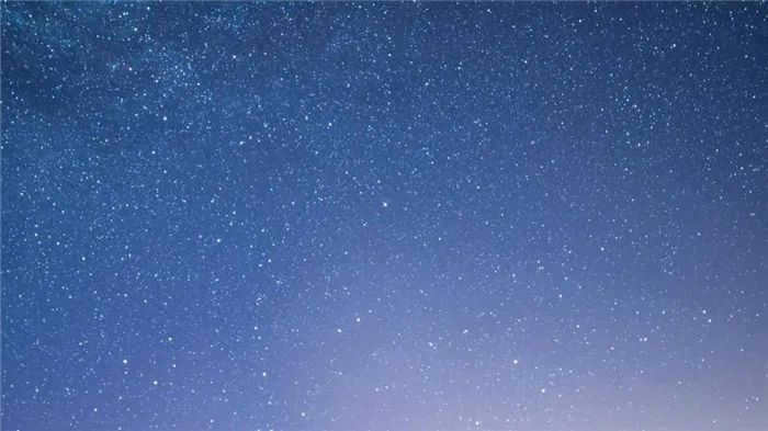
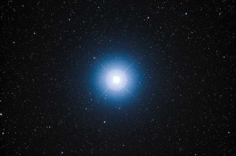
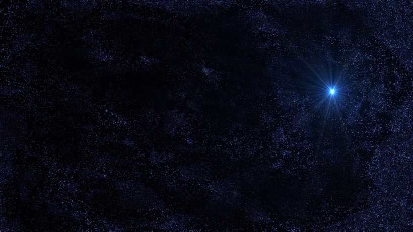
If you find yourself in unfamiliar territory, you can use celestial objects like the Moon and Polaris to help you navigate. In this article, we will focus on finding your way using Polaris, also known as the North Star. Polaris is a well-known star that has served as a guide for many travelers throughout history. People have relied on its light to lead them back home when needed. Even with a basic telescope that lacks powerful zooming capabilities, you can still spot Polaris in the night sky. Interestingly, upon closer observation, you may notice that it has a yellowish hue, which contradicts the common belief that it is white. Many astronomers agree that Polaris is actually much brighter than the sun, but this can only be perceived when both celestial bodies are viewed from the same distance.
- Polaris serves as a reliable guide for determining the northern direction, surpassing even a compass in accuracy. Positioned at the very center of the Earth’s North Pole, this celestial body stands out prominently in the night sky, making it an ideal reference point for navigating.
- While many mistakenly believe that Polaris is the brightest star, it is important to note that this assumption can lead one astray. Although Polaris possesses considerable power, it does not shine any brighter than its celestial counterparts. Therefore, it is advisable to exercise caution and rely on proven methods when searching for this navigational landmark.
- Polaris exhibits attributes of immobility and persistence. However, its position varies depending on the specific latitude.
- If you observed the North Star in a particular spot in Novosibirsk, there is no guarantee that you will see it in the same place in Moscow due to the difference in latitude. Additionally, the time of year and time of day can slightly alter the positioning of celestial objects.
Using Technology to Locate the North Star
If you are unable to locate the North Star using traditional methods, such as identifying constellations, there are other options available. One effective method is to use a camera.
Most people nowadays have access to a camera, increasing the likelihood of finding the North Star. Many individuals capture images of the night sky, when all the stars are visible. By examining these photos, you may notice numerous luminous trails of varying lengths, as well as a small circle. This circle represents the path of the North Star.
However, like everything else, there are specific details. In order to perform all of the aforementioned actions, you will need to configure your camera.
- Adjust the aperture to the maximum setting and select the appropriate light sensitivity, typically ISO is set to 400-600 in such cases. Neglecting this step may result in the photo being overexposed.
- Set the shutter speed to approximately thirty minutes to capture the tracks clearly.
- Photographing at night can cause moisture to accumulate on the device, so after taking the camera outside, allow it to rest on a dry yet cool surface for a few minutes to cool down and remove any condensation before shooting.
- Ensure that your device is securely positioned to avoid any motion that could potentially ruin your photo.
If you don’t have a dedicated camera, you can still capture stunning images of the night sky using mobile applications. For Android, one popular option is Stellarium, while iOS users can try out Sky Guide. There are several other similar apps available, but it’s important to note that the technical limitations of a smartphone camera may make it difficult to capture the mesmerizing trail of the North Star.
Written by the enormous bear
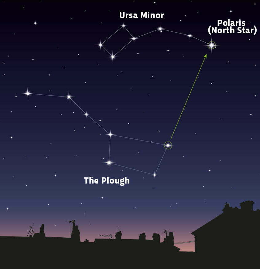
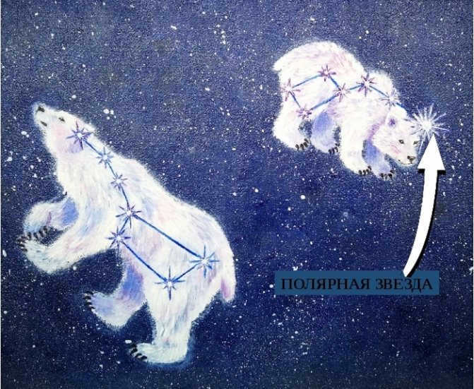
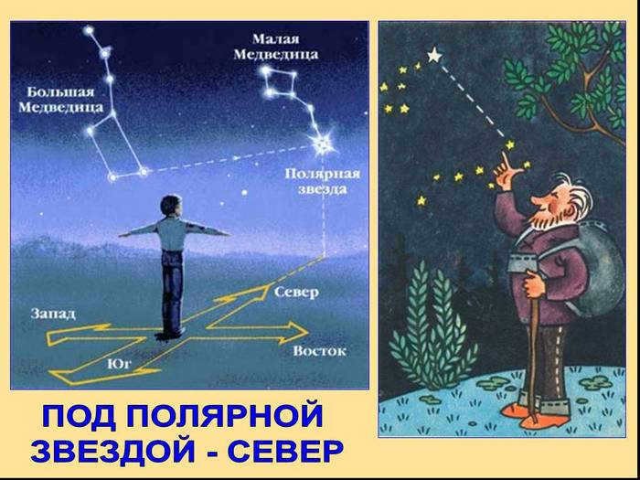
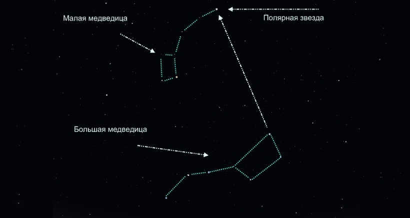
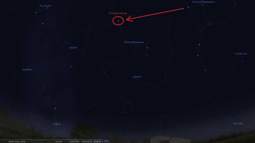
In order to locate the North Star, you may also utilize the constellation known as the Ursa Major, or the well-known Big Dipper. To accomplish this, wait until nighttime, preferably when the weather is favorable and the sky is clear. Locate the Ursa Major constellation, which will serve as a reliable guide in finding the Little Dipper, or Ursa Minor, by mentally drawing a line connecting the first stars of the Ursa Major. The endpoint of this line will lead you directly to Polaris, or the North Star. In other words, Polaris is situated at the very tip of the handle of the Little Dipper. Orient yourself towards Polaris and extend your arms outwards. By doing so, you will be facing north, with south behind you, west to your left, and east to your right.
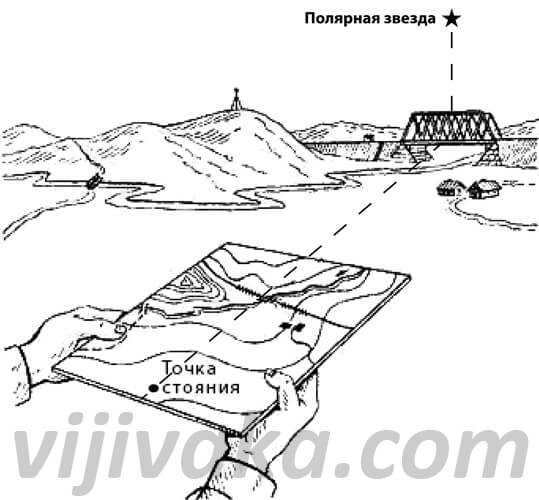
Using a map
Determining the location of the polar star can be done not only by observing the night sky, but also by using a map or atlas.
- Find a prominent landmark and align the map according to the position of objects on the ground. For example, if you are standing next to a river and see a house next to you, rotate the map so that the representation of the river and the house matches the actual layout.
- Verify that the map is oriented correctly by comparing the positions of known objects. For instance, if there is a factory on the left, it should also be on the left side of the map.
- The top section of the map will indicate the direction of Polaris, to obtain a more precise understanding of this location, employ a compass.

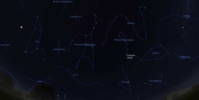
There are a number of methods to locate the Polar Star in the night sky. The most straightforward approach involves identifying the constellation known as the Big Dipper and utilizing a compass or map. Additionally, the Polar Star can be located in the night sky by observing other prominent constellations such as Cassiopeia, Swan, and Orion, which are easily distinguishable among the various celestial objects.
Discover more about orienteering with Polaris in a separate article….
Typically, orienteering with Polaris is a contingency plan when a compass or GPS is not readily available. On occasion, Polaris is utilized to ascertain compass correction, as it provides a more precise indication of true north compared to the magnetic compass needle.
Alternatively, there are situations where locating Polaris is purely for curiosity or other purposes. In these instances, one would typically have a compass, a map, and occasionally other tools to assist in this endeavor.
Polaris itself can be found within the constellation Ursa Minor, specifically in its “tail”. This constellation can be difficult to spot in the night sky, often being obscured by light pollution, particularly in urban areas. Therefore, Polaris is often identified with the help of neighboring constellations that are more prominent in the night sky.
Method 1: Locating Polaris using the Big Dipper
To locate Polaris using the Big Dipper, you must first find the constellation’s “bucket” and the two stars that form its “outer wall” opposite the “handle”. The lower star is called Merak, while the upper star is known as Dubhe. Next, draw a line from Merak through Dubhe, which will outline the “wall of the bucket”. On this line, at a distance of five segments Merak-Dubhe from Dubhe, you will find Polaris. Polaris stands out among the surrounding objects due to its brighter light.
A visual representation of this process is shown in the photo of the starry sky below:
Method 2: Using a compass to locate Polaris
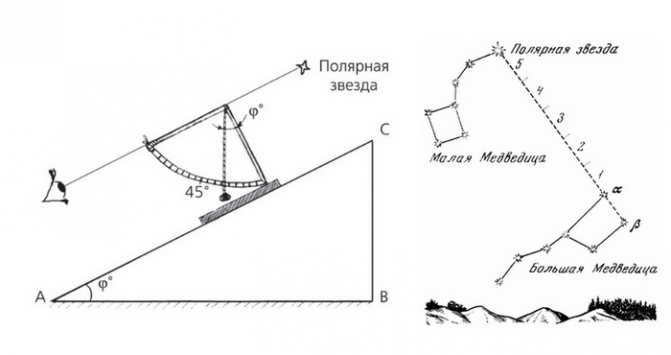
In order to locate Polaris using a compass, it is essential to determine both the direction and altitude of the star above the horizon. Typically, the hand of a magnetic compass points in a similar direction as the star, although there may be some slight deviation due to the discrepancy between the magnetic and geographic poles, as well as the distortion of magnetic lines. This deviation is referred to as the magnetic declination of the specific area and can be easily found in a reference book or online.
- The compass is a tool that is used to find the direction of north and adjust for magnetic declination. For instance, if the magnetic declination is towards the west and is 15°, then 15° is subtracted from the direction of the north end of the magnetic arrow and marked towards the right. On the other hand, if the magnetic declination is towards the east and is 10°, then 10° is marked towards the left. This will indicate the direction in which Polaris can be found. It is important to avoid taking these measurements in the vicinity of vehicles, power lines, railroads, and other objects that may interfere with the compass arrow’s behavior;
- The degree measurement of Polaris’ altitude determines its position in the sky. It will be roughly the same as the latitude of the observer’s location. To find out the latitude of your city or town, you can use the internet or any other convenient method. For example, in Odessa, the latitude is 40°29’10”. This means that Polaris will be observed at an altitude of approximately 40.5°.
- By knowing the angular altitude, you can estimate the star’s position in the night sky. This can be done using a sextant, a compass with an altitude function, a protractor with a weighted string, or another known technique.
Using a ruler, it is possible to roughly determine the location of Polaris based on its angular altitude. To do this, place the ruler vertically at a distance of 57 cm from your eyes and mark off a certain number of centimeters above the horizon level, corresponding to the calculated angular height in degrees.
For instance, in the case of Odessa, you would need to mark off 40.5 centimeters above the horizon. Polaris can then be found at this height.
There are numerous myths and legends surrounding this celestial entity. Several of these narratives perpetuate a false notion regarding the whereabouts of Polaris.
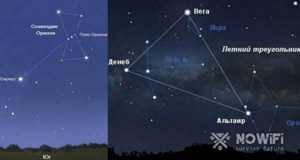
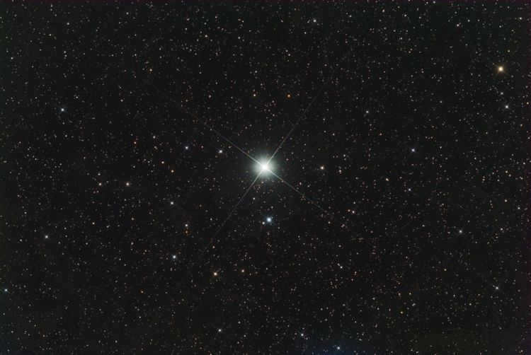
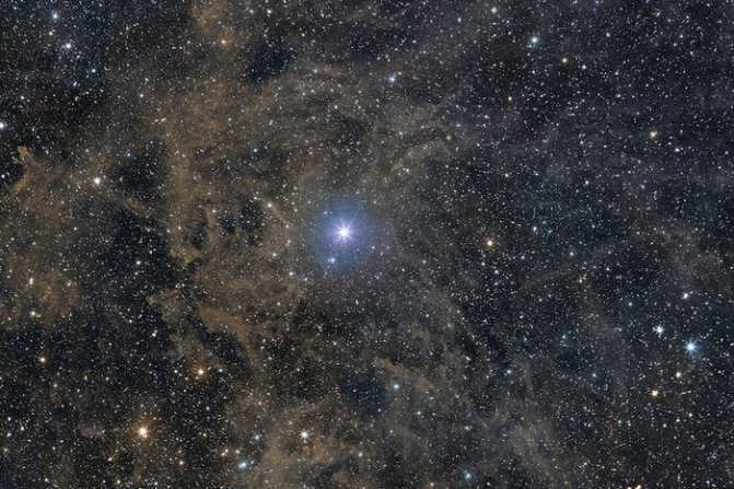
Figure 3: Many people often mix up Polaris with Sirius and Vega
Let’s discuss them in detail:
- The most common misconception is that Polaris is always directly overhead – it is not, the name itself indicates that its position is above the North Pole, and it can only be in the center of the sky there;
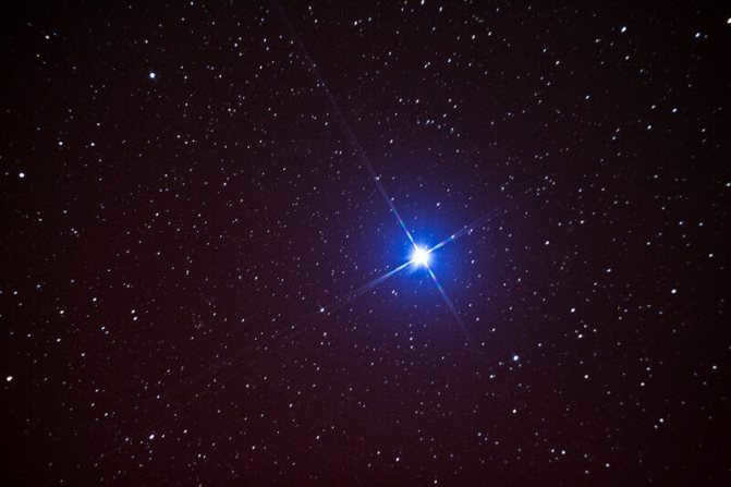
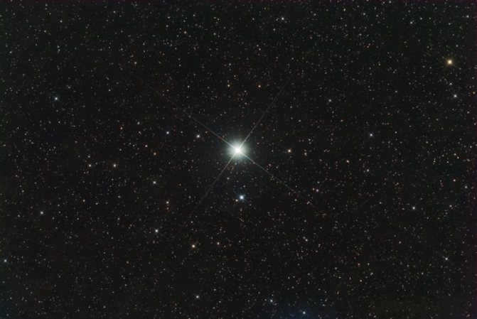
- If you are lost and believe that Polaris is the brightest point in the sky – you will never find your way, as its brightness or stellar magnitude is actually quite small. Instead, you will find Sirius or Vega (Figure 3) if you follow this principle;
- The claim that the star remains in the same position is only partially accurate – our planet is constantly rotating in relation to other fixed celestial bodies. While the luminous point is near the pole and appears to be stationary, it actually deviates by 1 degree. In other words, you won’t see the star in Moscow where it was two days ago in St. Petersburg because it will move closer to the horizon. Its location will constantly change depending on latitude.
Here are some additional intriguing facts:
- The star is genuinely helpful in determining the northern direction with more accuracy than a compass. This is because it points to the magnetic pole of the planet, which is different from the geographical pole and shifts by several kilometers each year.
- The star’s accuracy increases the closer you are to the northern hemisphere.
- The Earth’s axis shift has not always been the reason for the North Star’s position. Originally, it had no connection to the pole whatsoever. In approximately 13-14 thousand years, the bright star Vega will replace it, making it easier to locate the northern direction.
- Despite its significance, the North Star does not rank among the top 10 brightest celestial objects in the sky. It modestly holds the 48th position in this rating.
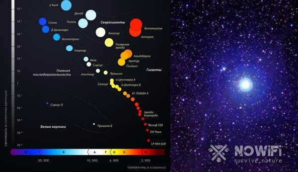
Figure 4: The primary categories of stars based on their size
What is the polar star in the sky:
- Polarissima, Cepheid, and Kinosura are just a few of the names used to identify its location;
- The latter is situated in the Little Bear constellation near the North Pole of the world;
- At different times, it has been referred to as Lyra and Vega, incorporating certain elements of Hercules and Dragon, Thuban and Cohab;
- It falls under the supergiants category (Figure 4) of the spectral class, with its distance from Earth calculated at 447 light-years or 137.14 parsecs;
- It is a triple star system, with the central star serving as the most well-known reference point for navigation.
Approach 3: employing a map
In the event that you do not possess a compass readily available, an alternative method to determine the direction towards Polaris involves utilizing a map with a sizable scale. One can acquire such a map from specialized stores or select newspaper stands. It is of utmost importance to ensure that the map in question is accurately scaled and not a mere children’s diagram or promotional pamphlet.
To orient the map, the observer positions himself on a linear landmark, such as a road, and aligns it with the corresponding feature on the map. The map is then rotated so that the direction of the linear landmark matches the direction on the ground. By comparing the surrounding objects on the map and on the ground, the observer can ensure that the map is correctly aligned and not rotated by 180 degrees. In other words, if a house, a park, or a body of water is shown to the right of the linear landmark on the map, it should also be located on the right side of the observer in reality.
There may be instances where a compass and map are not readily available, or when the Big Dipper is obscured by clouds and trees (or when the observer is located near the equator during the summer-autumn season). However, certain sections of the starry sky still display recognizable constellations that can be utilized for navigation.
How to locate the North Star in the night sky
The landscape can be traversed using celestial objects like the Moon and the North Star. Discover how to navigate by the moon in our informative article. Now, let’s discuss how to orient yourself using the North Star. The North Star, also known as Polaris, is a renowned navigational aid relied upon by countless travelers who depend on its light to find their way back home when needed. It is even visible with a relatively low-power telescope, without the need for zooming in. Upon closer inspection, one may observe that it actually appears yellow in color, contrary to the commonly held belief that it is white. Many astronomers and scientists concur that this star shines several times brighter than the sun, although this can only be appreciated when viewing these celestial bodies from the same distance.
- The North Star, also known as Polaris, always points towards the north and can be used to determine this side of the horizon. This celestial landmark is more accurate than a compass in finding the directions of the world because it is positioned right in the center of the North Pole on the globe. It can even be observed in the midst of the starry sky.
- There is a misconception that the North Star, Polaris, is the brightest star. However, relying solely on this belief can lead you astray. While Polaris does have a strong luminosity, it does not shine brighter than other stars. It is important to be cautious and utilize reliable methods when using this star as a navigational guide.
- Polaris possesses the qualities of immobility and constancy, but its position in the sky varies depending on the latitude.
- If you happen to spot a polar star in Novosibirsk at a specific location, it doesn’t necessarily mean you’ll be able to see it in Moscow due to the difference in latitude. Moreover, the position of celestial objects can also be influenced by the time of year and day.
Utilizing Technological Resources
So, in the event that you are unable to locate the North Star using traditional methods, such as identifying constellations, due to circumstances such as their absence in the sky, there is an alternative option available. Technical resources, such as a camera, can be utilized to overcome this challenge.
In today’s age, it is quite commonplace for individuals to possess a camera, thus increasing the likelihood of capturing a glimpse of the North Star. Many individuals partake in nighttime sky photography, taking advantage of the visibility of all the stars. This process entails capturing long exposure images, resulting in the presence of numerous luminous trails of varying lengths. Among these trails, a small circular pattern can be observed – this is indicative of the North Star’s trace.
- To ensure proper exposure, it is important to maximize the aperture and select the appropriate ISO. In most cases, ISO values of 400-600 are recommended. Failing to do so may result in a backlit photo.
- In order to capture clear tracks, the shutter speed should be set to approximately thirty minutes.
- When shooting at night, it is possible for condensation to form on your device. To prevent this, it is recommended to allow your camera to cool down on a dry but cold surface for a few minutes after taking it out before you begin shooting.
- Ensure the stability of your device, as even the most minor movement could potentially spoil the photograph. In the event that you do not possess a camera, it is still feasible to take pictures of the night sky with the aid of mobile applications. For Android users, Stellarium is an excellent option, while iOS users can opt for Sky Guide. There are numerous apps available for this purpose, although it is important to note that due to the limitations of the camera, capturing the trail of the North Star may prove to be challenging.
By the Great Bear
In order to locate the North Star, you can also utilize the Great Bear constellation, or what is commonly referred to as the Big Dipper. To accomplish this, wait until nighttime, preferably under clear skies. Locate the Great Bear constellation, which can serve as a helpful guide in locating the Little Dipper. To do this, mentally draw a line between the first stars of the Great Bear, and the end of this line will point towards Polaris. In other words, it is situated at the very beginning of the handle of the ladle. Orient yourself towards it and extend your arms outwards, and you will have north in front of you, south behind you, west to your left, and east to your right.
Using an atlas
In addition to observing the sky, you can also determine the location of the polar star by using an atlas or map.
- Find a prominent landmark and position the map according to the orientation of objects on the ground. For example, if you are standing next to a river and see a house next to you, align the map so that the river and the house are represented accurately.
- Ensure that the map is oriented correctly by comparing the positions of known objects. For instance, if a factory is on the left side, it should also be on the left side of the map.
- The top part of the map will indicate the direction of Polaris, although using a compass will provide a more precise indication of its location.
Alternative Methods for Finding Polaris
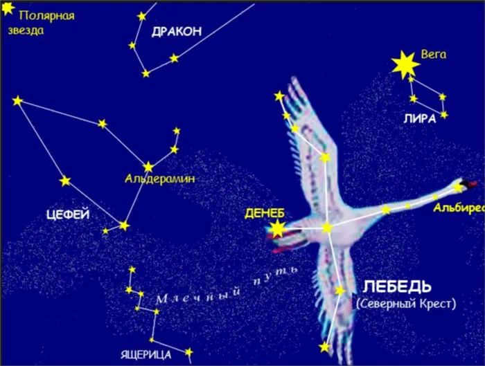
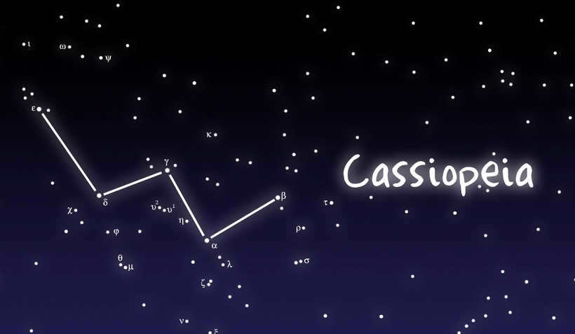
Locating Polaris, the North Star, is not always feasible using the prominent Big Dipper constellation. Sometimes, cloud cover or obstructions such as trees and tall buildings can obscure its view. However, an alternative method involves using the constellation Cassiopeia. Recognizing Cassiopeia is relatively simple; it resembles an inverted or sideways letter “m” or the English letter “W.” Keep in mind that the edges of the constellation may appear slightly stretched. By following the central arrow, one can consistently find the Little Bear constellation, which contains Polaris.
To ensure accuracy in the search, one can also locate the Big Dipper or another constellation, Cepheus. Cepheus resembles the shape of a house’s roof, and Polaris is located nearby.
Cassiopeia and Polaris are on opposite sides of the Big Dipper. Polaris appears to be sandwiched between these two constellations. Therefore, finding Polaris is just as easy using Cassiopeia as it is using the Big Dipper. To do this, draw a straight line through the two outermost stars of Cassiopeia. Repeat the same process with the two outermost stars on the other side of the constellation. The point where these two lines intersect is the starting point for another line that passes through the middle star of Cassiopeia. Along this line, measure a distance equal to two times the distance between the outermost stars of Cassiopeia. Polaris can be found at this point.
This technique is as uncomplicated and convenient as locating Polaris by means of the Big Dipper constellation. Occasionally, when near the equator during the summer season, the Big Dipper may be below the horizon, even though Polaris remains visible. In these scenarios, Cassiopeia is also visible and the star can be relatively easy to locate.
Orienteering using the Orion constellation
The Orion constellation can be observed from any location around the globe, making it a useful tool for determining direction in both the northern and southern hemispheres. However, it is only visible during the winter season.
Orion is comprised of seven stars and has a distinct hourglass shape. The center of the constellation is formed by three stars known as the Orion Belt. In the morning, the eastern direction can be determined by the rightmost star of the Belt, while in the evening, it indicates the western direction.
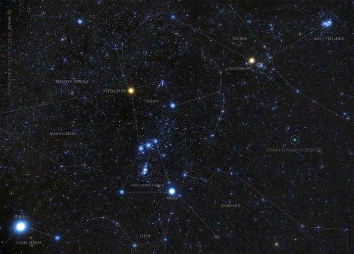
The constellation Orion
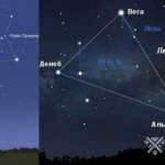
Method 5: using the constellation of Cygnus
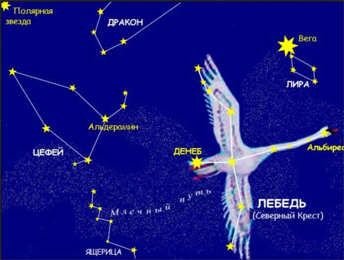
Another way to determine the position of Polaris is by using the constellation of Cygnus, also known as the Swan. To do this, draw a line from the star Alpha Cygni through the star Deneb. From Deneb, mark off a segment equal to twice the distance between Alpha Cygni and Deneb. This will give you an approximate location of Polaris, which is the brightest star in that area.
Helpful tips
Keep in mind that Polaris can only be seen in the northern hemisphere. In the southern hemisphere, it can be observed within a range of 85 km from the equator, or under favorable weather conditions caused by light refraction or when the observer is at a higher elevation.
There is a widespread belief that Polaris is one of the most luminous stars in the night sky. However, this is not accurate: its apparent luminosity is considerably dimmer than that of stars like Sirius and Canopus, as well as planets such as Venus and Jupiter, which can be mistaken for stars by an uninformed individual. Nevertheless, in comparison to nearby stars, Polaris stands out with a more radiant gleam. As a result, when using constellation lines, a compass, or a map, precise accuracy is not necessary: it suffices to locate the general vicinity of the star, and within this region, it will already be the most brilliant.
The North Polar Star of the Earth is not a solitary celestial body. It is comprised of a primary luminous entity known as α Umi Aa and the adjacent satellites α Umi B and α Umi Ab. Additionally, there exist two other cosmic components, α Umi C and α Umi D, which bear a distant relation to it.
Within the Little Dipper, a collection of stars that is easily recognizable, lies the companion α Umi B, which was discovered by the English astronomer William Herschel in 1780. This group of stars, along with the constellations of the Big Dipper, Cassiopeia, and Orion’s belt, are among the most well-known.
Humanity is aware of the following information:
Polaris, also known as the North Star, shines brightly in the night sky and serves as a crucial navigational tool for travelers, fishermen, and hunters. Its position provides valuable guidance, particularly in the dark, and knowing how to locate it can be a lifesaver in challenging situations.
Polaris indicates the direction towards the North Pole

Determining geographic latitude using stars – the first method
One can determine the geographic latitude by observing the position of Polaris. If we assume that Polaris indicates the North Pole, then the height of Polaris above the horizon provides an estimate of the geographic latitude of the observation location. To obtain a more accurate measurement of latitude, one can measure the height of Polaris during its upper and lower culminations.
How to Locate Polaris in the Sky
Polaris, also known as the North Star, is the brightest star in the constellation of Ursa Minor. However, it can sometimes be mistaken for another star. Therefore, when trying to find this important celestial landmark, it is best to start by identifying the surrounding constellations. This method is particularly accurate because the stars within a constellation are fixed in their relative positions and do not move.
It is recommended to search for Polaris on clear nights when the sky is not obstructed by clouds and offers a full view. During these optimal conditions, you can also use the position of nearby groups of stars as a reference point to locate the North Star and navigate the night sky.
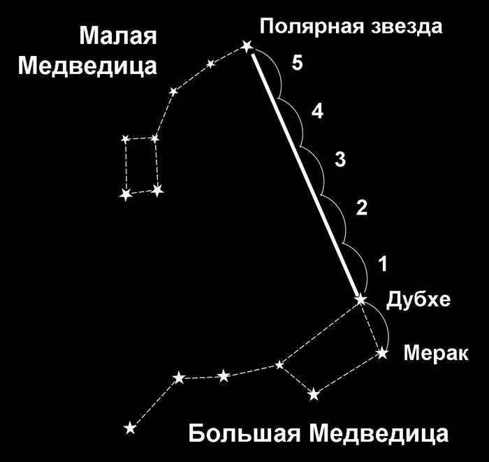
Diagram illustrating the process of locating the North Star
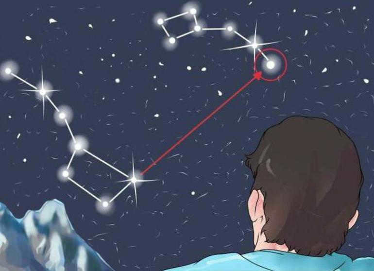
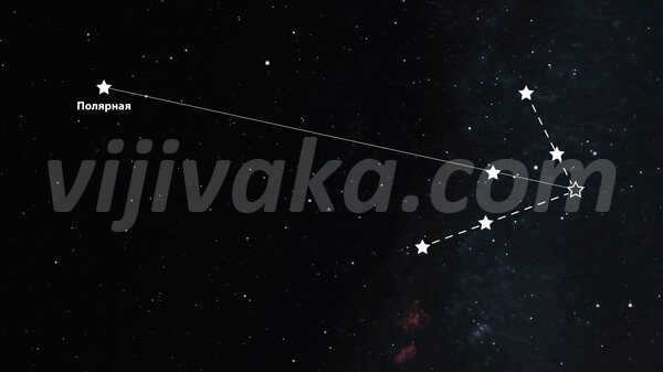
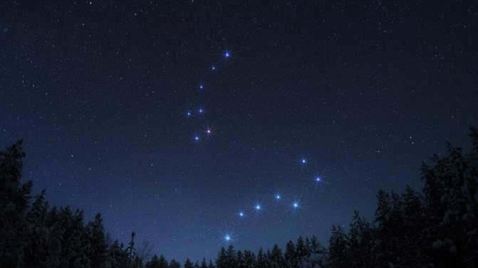
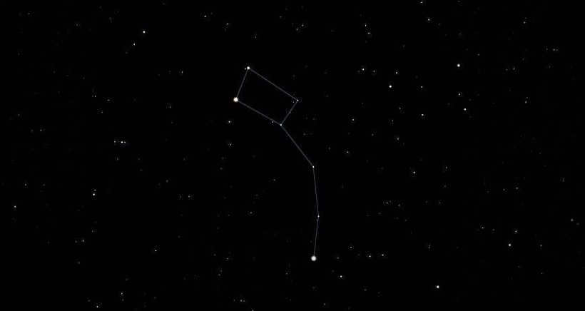
Using the Big Dipper
One easy and efficient way to locate Polaris at any time of the year is by using the Big Dipper constellation. The Big Dipper is more prominent and recognizable than the Little Dipper, making it accessible even for inexperienced stargazers.
In the Northern Hemisphere, the Big Dipper is visible throughout the year, but its position changes. In winter, it is closer to the horizon line. It then moves counterclockwise towards the east, with its “tail” pointing downwards, and reaches its highest point in late spring. In summer, it descends on the west side.
When you gaze up at the night sky, it may appear that the Big Dipper consists of only seven celestial bodies. However, in reality, there are many more stars that make up this constellation. It is not only simple but also fascinating to locate a cepheid near this constellation. To accomplish this, you must follow the following algorithm:
- Locate the Big Dipper constellation.
- Take note of the two rightmost stars in the Big Dipper.
- Imagine a straight line connecting the star Merak (found at the base of the ladle) to Dubhe (positioned above it).
- Extend this straight line until it reaches the North Star.
Attention!
When utilizing this technique to locate the North Star, it is crucial to ensure that the line connects precisely the Big and Little Dipper. It is important to note that the prominent constellation should consist of 7 discernible stars. Novices frequently mistake the genuine Polaris for Venus or the solitary star Sirius, as they are highly noticeable while carrying out the computation.
The Constellations Ursa Major and Ursa Minor
Using a compass and a map
It is possible that the night sky may not be easily visible. Weather conditions and the traveler’s location can make it difficult to find the North Star. However, if it is necessary to determine the north and other directions of the horizon, orienteers can use tools such as a map and compass.
If a magnetic compass is used instead of an electronic one, it is important to consider the influence of magnetic fields on the compass needle. A correction is made for the magnetic declination in order to obtain a more accurate reading. This will help determine the correct path.
- The compass is utilized for determining the north direction. It is crucial to consider the declination, which needs to be known beforehand. Starting from the north-facing arrow of the compass, the angle is adjusted to the left if the magnetic declination is to the west. Conversely, if the magnetic declination is to the east, the angle should be adjusted to the right.
- The next step is to calculate the altitude of the star, which is nearly identical to the latitude of the observer’s position. This will enable more accurate determination of its coordinates.
- The third step involves working with a topographic map. The map needs to be aligned with its upper part, indicating the north, in the direction of the celestial body. Then, orientation is performed by noting the visible objects on the map.
In order to ensure the accuracy of measurements, it is imperative to adhere to the primary guideline: experiments must not be carried out in close proximity to electrical power lines or railways. Failure to do so could result in the distortion of readings due to electromagnetic waves.

If the sky is obscured by clouds, a map and compass can be utilized to find the North Star.
By Cassiopeia
Locating the North Star can also be aided by identifying other groups of related stars. The method involving the well-known constellation Cassiopeia is just as simple as using the Big Dipper.
Cassiopeia is positioned on the opposite side of the Big Dipper. These constellations are easily visible in the night sky, along with the North Star, which lies between them.
Utilizing this method involves the following steps:
- Visually draw two lines that pass through the outermost points of Cassiopeia on both sides.
- The lines are extended until they intersect one another.
- At the point of intersection, a third straight line is drawn, passing directly through the center luminary of the constellation.
- This line should be approximately the same length as the two segments connecting the outermost points of Cassiopeia, so that it aligns with Polaris.
This technique is useful for navigating during the summer months when observing the constellation near the equator. In this location, the Big Dipper is below the horizon line, making it impossible to observe the constellation.
Using the Swan star to locate Cepheids on the celestial sphere
Individuals with expertise in astronomy are capable of locating the Cepheids on the celestial sphere by utilizing the Swan star. This method presents a challenge due to the Swan star not being the brightest or most prominent luminary. However, the Swan star search can prove beneficial when clouds obstruct a portion of the sky, including Polaris itself.
In order to carry out the search, the following steps must be taken:
- Firstly, locate the two primary stars of the Swan, namely Deneb (Alpha of the Swan) and Gienach (Genach, Epsilon of the Swan). These luminous points serve as the reference points for the search.
- Once the necessary stars have been identified, draw a line through them.
- From Deneb, extend this straight line to a length twice that of the segment between the lower points of the constellation.
- The desired celestial object will be reached when the imaginary line is drawn to its end.
Looking for the Swan constellation can be challenging.
Orion
This technique is also not considered easy, but it can be utilized by those who have experience in astrometric calculations. Searching by Orion can be helpful when it’s difficult to determine the north direction due to clouds obstructing parts of the celestial map.
How to search for the Guiding Star using the Orion constellation:
- First, locate the Belt of Orion on the celestial sphere;
- Then visually draw a line from the midpoint of the Belt through Meissa, which is part of the constellation;
- The resulting line should pass near the bright star Capella, which is the outermost object of Orion;
- Continue drawing the line until it reaches the main star of the Northern Hemisphere;
- The length of the beam should be the same as the combined distance from Orion’s Belt to Capella and from Capella to Polaris.
The technique of locating a reference point using the Orion constellation is specifically employed during the autumn and winter seasons. This is primarily due to the fact that the stars are positioned at the precise distance required for accurate determination of the north direction. Additionally, Orion’s belt can only be observed in the night sky of the Northern Hemisphere during the fall and winter months.
How to find your way using the North Star
When a stranded traveler is unable to rely on modern gadgets or a compass to navigate the terrain, it is important to remember alternative methods that utilize natural landmarks. In northern regions, one common method is using the North Star for orienteering.
There are several benefits to using the North Star to determine direction. The North Star, also known as Polaris, is always near the Earth’s axis of rotation, which means its position remains relatively constant. Additionally, the North Star can be observed without any special equipment, making it a simple and accessible tool for nighttime navigation.
Polaris, has been responsible for the rescue of many human lives
Heading towards the north
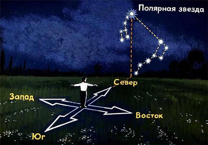
Even those with little experience in traveling are aware of how to determine the cardinal directions by observing the North Star. To do this, simply face Polaris and envision a straight line that is perpendicular to the horizon.
Read also: Determining your location on a map based on landmarks, measuring distances, and using directional cues.
Thus, directly in front of the observer’s face will be the north, while the south will be behind. The east is located on the right side from the point of intersection of the beam with the Earth’s surface, and the west is on the left.
How to Calculate Latitude
One unique characteristic of the northern luminary is its ability to help determine latitude. By measuring the angle between the luminary and the horizon, one can calculate their latitude.
Due to its proximity to the geographic pole, this celestial object has minimal movement. However, depending on the observer’s location, the luminary’s height above the horizon line can vary. For example, at the North Pole, the luminary will be directly overhead (at the zenith), while at the equator, it will appear very close to the horizon line. Therefore, the angle measurement will correspond to the latitude of the specific location.
In the past, navigators were well-versed in determining their latitude and would measure the height of the starry landmark each night.
Measuring latitude using the polar star is a common method used to determine one’s location on Earth. By observing the position of the polar star in the night sky, navigators can accurately calculate their latitude.
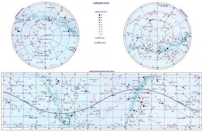
Using a Star Chart to Determine Orientation
Star charts are useful tools for navigating the night sky. They provide information about the position of stars and other celestial objects at different times and locations. By referencing a star chart, observers can identify which stars are visible at a given time and in which direction they are located.
One common question when using a star chart is how to determine which stars are visible in the east and west. By consulting the star chart and identifying the celestial objects in those directions, observers can orient themselves and navigate the night sky with ease.
Both issues can be resolved simultaneously, but first, we need to reach an agreement on what should be considered as the eastern and western directions. Typically, we divide the visible sky and the visible portion of the Earth’s surface into two halves: either north and south or east and west. It is commonly stated, for instance, that “the sun rises in the east and sets in the west.” Although this statement is correct, it is too imprecise since the sun rises and sets in different locations each day. It would be more accurate to define four specific points instead of relatively abstract sides – south and north, east, and west. These points can be denoted as follows.
During the evening hours, position yourself beneath the expansive expanse of the open sky, locate the Polar Star, and orient yourself towards it – this will align you in the precise direction of north. Proceed to sketch a lengthy and perfectly straight line directly ahead of you on the ground, while simultaneously envisioning that you have extended this line all the way to the visible edge of the sky. The exact spot where your hypothetical line intersects with the distant horizon line will signify the precise location of north..
After progressing a few paces along your designated line, pivot and gaze directly ahead along this path. This will serve as a marker for the definitive point of south on the horizon line.
Create an additional line perpendicular to your original line, resulting in a symmetrical cross with perfectly straight, 90-degree angles. Position yourself in the center of the cross, at the intersection of the two lines you have drawn, and visualize extending the ends of the cross line to the horizon. The points where these extended lines meet the horizon will represent the eastern point and the western point.
Commit to memory the locations of the south, north, east, and west points in your surroundings so that you don’t need to mark them every time. To do this, identify a specific tree, bush, or building at each point, making sure to choose targets that are as far away from you as possible. If you choose targets that are too close, you may need to change your position slightly, causing them to no longer align with the north, south, east, and west points.
Don’t forget about the fifth point in the heavens – the zenith. If you were to place a tall, vertical pole at the intersection of two lines in the center of your cross, and envision that the top of this pole extends all the way up to the sky, the point where it meets the sky would be the zenith. Furthermore, if you were to imagine that the pole extends downwards through the Earth, passes through the center of the globe, and emerges on the other side where it also meets the sky, you would have a fifth point in the sky opposite to the zenith, known as the nadir in the field of astronomy.
You might find the following information intriguing:
Why Polaris is renowned
When gazing at the night sky, Polaris may not immediately stand out. There is a common misconception that it shines brighter or emits a different hue compared to other stars. However, this belief about the star is inaccurate.
Polaris gains its fame for other reasons. Firstly, this celestial body is situated near the geographic pole. By observing it, one can always determine the direction of north. Throughout the centuries, this has allowed people to construct precise routes and navigate without getting lost, even while at sea.
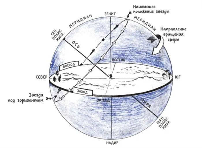
Secondly, all celestial objects complete a full revolution within 24 hours, yet the Guiding Star remains fixed in its position. This phenomenon can be explained by its location directly on the line that connects the north and south poles, as well as being at the center around which other luminous entities rotate on the celestial sphere.
Thirdly, because Polaris can not only provide orientation and determine the cardinal directions, but also calculate the latitude of your location. To do this, it is necessary to ascertain its altitude, which is the angle between the direction to the star and the horizon. The resulting value will represent the latitude.
Throughout history, the celestial point at the pole of the world has held great significance for astronomy, as well as for world travelers and explorers. However, it should be noted that only individuals in the Northern regions are able to observe it. In the southern hemisphere, there is no prominent landmark near the imaginary line of the pole.
Polaris remains fixed in its position in the sky.
Using the Stars for Navigation at Sea
Determining the precise location in the open sea can be extremely challenging. Nowadays, large ships and liners as well as small vessels are equipped with advanced navigation systems that plot the course and indicate any deviations in degrees to the nearest minute.
However, there have been historical instances of computer viruses attacking the navigation equipment, which forced sailors to drift at sea for weeks on end while waiting for an IT specialist.
Also read: The Subarctic Zone – Geographical Location, Characteristics, and Plant Description
Many amazing discoveries and journeys took place well before computers were introduced on seafaring vessels. Vikings, Polynesians, renowned scientists, and ordinary travelers relied on their ability to navigate using natural signs and the night sky.
How the earliest seafarers navigated
Polynesians traversed the Pacific Ocean in their canoes long before Columbus stumbled upon America. They traveled thousands of kilometers between Polynesian islands and always reached their intended destinations. Their primary navigational aids included the sun, stars, moon, wind, and ocean currents.
Furthermore, archaeologists have uncovered ancient maps created by these seafarers. These maps were crafted from shells and sticks and differ significantly from the ones we are familiar with today.
The Vikings were not far behind and journeyed between Northern Europe, America, the British Isles, Iceland, and Greenland. They were known for their keen intuition, remarkable vigilance, and astute calculations. They sailed downstream, closely observing the whales, and each ship housed a trained raven, dispatched to scout for signs indicating the direction of the shore.
Additionally, they utilized a sundial for navigation. They could estimate the ship’s speed, track the days elapsed during the voyage, and even utilized the polarization of light to navigate through inclement weather. Nevertheless, their calculations were imprecise, and the absence of wind, fog, and cloudy conditions gave rise to legends where adventurous Vikings lost their way and became disoriented.
The Great Longitude Debate
The concept of using coordinates to accurately determine one’s current position was first introduced in Ancient Greece around 200 BC. Through extensive research and contemplation, the greatest minds of the time were able to develop a precise understanding of geographic longitude and latitude by 100-160 years AD.
Claudius Ptolemy, a renowned scholar, is credited as the founder of this theory. His groundbreaking work provided navigators with the ability to estimate their position and make necessary course corrections. However, the calculation of coordinates proved to be more challenging than initially anticipated. While latitude could be determined using the Sun, Moon, and other celestial bodies, calculating longitude remained an elusive task.
In order to achieve this objective, it was essential to compute the disparity between the current position’s time and a hypothetical point’s time at the same instant. Initially, mariners encountered difficulties in accurately ascertaining the precise time at their current location, and it proved to be even more challenging to determine it at another fixed point (such as the point of departure or the Greenwich meridian). Even approximate calculations proved inadequate, as a one-degree deviation in longitude at the equator is equivalent to 110 kilometers.
This is fascinating! The predicament of determining the time at the second fixed point remained an unsolvable conundrum for such an extended period that Louis XVI accused the astronomers of France of incompetence. According to him, they were to blame for a series of unsuccessful attempts to uncover new lands.
Since the 16th century, the leading maritime powers (Spain, Holland, Portugal, Italy, England) have been fiercely competing to become the pioneers in developing the most precise and dependable method for determining longitude. The English government declared that a remarkable prize of 20 thousand sterling would be awarded to the discoverer. In the 18th century, watchmaker John Harrison introduced his revolutionary creation – the chronometer – to the world and received the majority of the promised prize.
Simultaneously, the sextant was invented – a device used for sun-based orientation. This innovation was the result of collaboration among several brilliant scientists, including Isaac Newton, John Headley, and Thomas Godfrey.
By utilizing these two tools, seafarers had the capability to precisely ascertain their present location. The navigator relied on the sextant to gauge the sun’s elevation above the horizon and compute the precise time. This data was then compared to the chronometer, which displayed Greenwich Mean Time. Through the process of subtraction, the longitude could be determined.
What’s available to us today
In the modern era, sailors no longer have to engage in complex calculations, thanks to the installation of automatic navigation systems on board. This enables sailors to dedicate more attention to studying the surrounding environment, including factors such as weather conditions, the ship’s velocity, and the contours of the ocean floor. Some crucial decisions are even based on these observations. The introduction of computerization and autonomous operation has greatly enhanced the safety of navigation.
The most commonly used navigation system today is the ECDIS, and when a ship opts for electronic charts over traditional paper ones, they typically install at least two independent computers and separate displays to ensure redundancy.
What happens in the event of a sudden breakdown?
Simply duplicating the navigation system does not guarantee immunity from computer malfunctions or failures. There are numerous potential causes for such issues, ranging from system requirements for map updates to the possibility of a hacker attack. As sailors operate the system, they identify its weakest and most vulnerable points. Developers then work to address these issues, continually creating something new in the process.
In the event that the system fails, the situation is not as dire if the ship is close to shore or in a narrow passage. In these cases, the captain can request a map of the area with precise coordinates for “dangerous” zones from the shore, and sailors can rely on their smartphones for navigation. Additionally, visible landmarks can be used as guides. However, if the navigation systems fail while the ship is in the open sea, far from land, the crew will encounter significant difficulties.
The GPS system can also be inaccurate: it is vulnerable to electromagnetic interference, and even pirates can manipulate the ship’s course. They acquire a device that disrupts communication between the GPS and the traveler’s signal. All the sensors on the ship’s dashboard may appear normal, but the ship itself will be hijacked by intruders and directed to an unknown destination.
To avoid such errors at sea, numerous academies worldwide continue to teach cadets ancient methods of navigation using stars, the Sun, and the Moon, as these mistakes can lead to catastrophic consequences. The ship could collide with dangerous reefs or become stranded.
Nevertheless, it is relatively challenging for a ship to become truly lost among the numerous sea routes – eventually, another vessel will emerge on the horizon and contact a rescue team for assistance.
One can potentially become disoriented almost anywhere. The key is to remain calm and recall all the natural signs for navigating the terrain, not just during the day using the sun, but also at night using the starry sky.
Fascinating information about Polaris
Polaris is not the most luminous star in the sky
Many individuals without extensive knowledge of astronomy incorrectly assume that Polaris is the most well-known and brightest star. This is a widely held misconception.
This celestial body actually ranks 46th on the list of the most luminous celestial bodies. Therefore, if you are observing the starry sky in an urban environment, locating Polaris can be challenging. However, it is considered the brightest object in the constellation of Ursa Minor.
The misconception about Polaris arises from its widespread popularity and its status as the primary natural landmark. However, the key characteristic of Polaris is its stationary state, which is a result of its proximity to the Earth’s axis of rotation.
Polaris’s brightness has increased over time
It is a known fact that the Cepheid variable star was less bright in the past. Over the last 100 years, its brightness index has risen by 15%.
Scientist Scott Engle made a conscious choice to not dwell on the examined and analyze the materials of past astronomers, starting from Ptolemy (137 AD). Upon completion of the study, he arrived at the conclusion that the luminous celestial body at the pole has undergone a 2.5-fold increase in brightness compared to 2,000 years ago. These findings challenge the prevailing theory of stellar evolution, nonetheless, they have been published in the esteemed scientific journal Science.
Polaris is known by various names.
On Earth, Polaris is the Alpha star of Ursa Minor.
This celestial body holds a unique position in Earth’s sky. The rotational axes and orbital inclinations of other planets differ from Earth’s. As a result, each planet has a different pole star.
For instance, Mars also has a visible pole star called Kinosura. However, in the southern hemisphere, Kappa Sails is defined as the pole star, while at the North Pole, two stars, Sadr and Deneb, from the constellation Northern Cross, serve as the pole stars.
Time of the supermassive star
Currently, the Cepheid star is classified as a supermassive star with a relatively short lifespan. These stars possess physical characteristics that indicate they are very old, although their actual age is not necessarily extensive. In reality, the Cepheid star is no more than 70-80 million years old.
Presently, the star is observed to have a yellow hue. However, it did not always exist as a supermassive star. It is likely that in its initial stages, the star appeared light blue and had a temperature that was approximately three times higher than its current state.
The most extraordinary cepheid star
The fluctuation of the star’s luminosity is caused by the transformation of hydrogen into helium. Consequently, the core contracts while the outer shell expands, leading to fluctuations in brightness, temperature, and size.
These changes are imperceptible to the naked eye. However, the pulsations of Polaris have a precise periodicity. Currently, it is observed that the oscillations occur every 3.97 days.
Polaris is one of the most intriguing and unique celestial objects under examination. It consists of a system of three stars, with one of them undergoing specific pulsations. Furthermore, its position in the sky enables navigation without the need for special equipment, allowing for the creation of routes in unfamiliar terrain.
Did you find this information helpful? Feel free to share your thoughts in the comments section!
Closest and Brightest Cepheid Star
Polaris, known as the nearest and brightest variable star of the Earth, belongs to the Delta Cepheus type. It has a pulsation period of 3.97 days. These types of stars are referred to as cepheids, which are characterized by their periodic changes in brightness due to pulsations. However, Polaris is a unique cepheid, as its pulsations gradually diminish over several decades. In 1900, the change in brightness was approximately ±8%, whereas in 2005, it was around 2%. Additionally, the star has become on average 15% brighter during this time.
Interestingly, Polaris is actually a triple star system. The central star of the system is a supergiant, known as Polaris A.
), 2,000 times more luminous than our Sun. Its companion
Polaris B
has been recognized by scientists for a considerable period of time. It is situated at a respectable distance from Polar A, making it easily visible through telescopes even from Earth’s surface. However, the small companion of the central star.
Polaris Ab
– is in such close proximity to the giant that only Hubble was able to capture an image of it, and only after making adjustments to the equipment. Polaris Ab has an estimated orbital period of approximately 30 years.
(From Wikipedia)
This article explores the fundamental techniques for locating this prominent feature in the sky of the northern hemisphere. We trust that these pointers will assist you in revamping your space in the proper manner.
Polaris, also known as the North Star, is situated in the constellation Ponytail, which is the furthest star in the sky. It can be located within the Ursa Major constellation.
Knowing how to locate Polaris is incredibly useful for navigation purposes, as it serves as a reliable indicator of the north direction. Astronomers often use Polaris to correct the equatorial base, as it remains stationary in the sky despite the Earth’s daily rotation.
Polaris holds a special place in astronomy due to its prominent position. It is a great topic to discuss with children and can be used to expand their knowledge about the night sky. Many children have heard of Polaris but are unaware of its exact location, so teaching them about it can be educational.
How to locate Polaris in the night sky
Finding Polaris can be done easily by using the Big Dipper as a guide. This well-known constellation can be seen in the northern hemisphere throughout the year. However, it’s important to note that the position of the constellation changes as the celestial spheres rotate counterclockwise. During the winter months, the Big Dipper can be seen approaching the horizon, while in spring it can be found “on the tail” in the east. In late spring, it is almost at the zenith, and in summer it starts descending in the west.
The Little Dipper also resembles a dipper shape, but it’s not as recognizable and the stars within it are not as bright. Therefore, it’s easier to locate them at the beginning of the Ursa Major constellation.
Finding Polaris is a breeze – simply connect the two farthest stars of the Big Dipper with an imaginary line and extend it. Polaris will be located about five times the distance between these stars.

Discovering the location of the celestial Polaris by utilizing the Big Dipper.
Adjacent to it lies another remarkably prominent constellation, Cassiopeia, resembling the Great Western. This constellation can sometimes be more easily located than Polaris due to its captivating shape, which guides you towards the sighting of Polaris.
What makes Polaris so renowned
If you happen to spot Polaris in the night sky for the first time, you might find it unremarkable – just another star amidst the countless others. However, for some inexplicable reason, many individuals perceive it as rather exceptional – perhaps brighter or possessing a distinct hue. Yet, in reality, it is merely an ordinary star with a magnitude of +1.97m, placing it at the 50th position on the list of brightest stars.
Nevertheless, Polaris is famous for an entirely different reason. Situated near the Earth’s pole, it provides an almost guaranteed indication of the north and boasts a divergence of less than one degree. For centuries, people have relied on Polaris to navigate both on land and at sea.
Terrain Orienteering.
In addition to being able to determine the exact position of north using the stars, you can also calculate the latitude. This can be done by measuring the angle at which the North Star is above the horizon – this angle, measured in degrees, represents the latitude of the observation. This method has been used by sailors and explorers for centuries, making Polaris commonly referred to as the Guiding Star. It provides guidance and ensures that one does not lose their way.
Polaris can be found in the direction of the North Pole of the world.
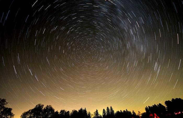
As the Earth rotates throughout the day, all the stars move across the sky. However, Polaris remains fixed in its position. This is because it is located along the north-south axis, around which the celestial sphere rotates.
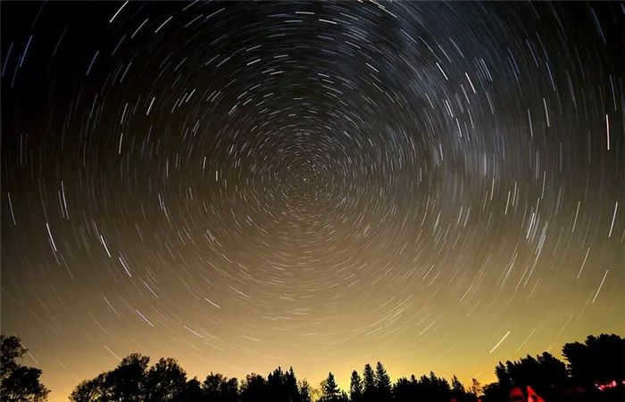
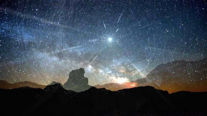
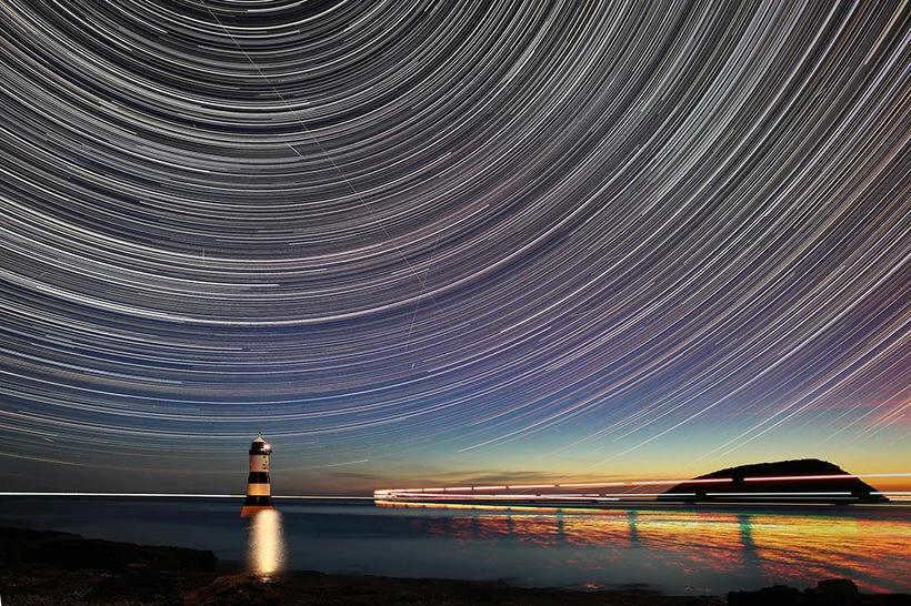
These images can be captured using extended exposure times. By doing so, all the stars create a trail, a path, as they move across the sky. However, Polaris, located at the center, remains stationary.
Polaris holds a special significance, despite its lack of brightness. Interestingly, in the southern hemisphere, there are no similarly bright stars near the south pole of the world. This means that those living in the northern hemisphere are fortunate to have a reliable point of reference in the sky.
Polaris, located in the Lesser Ursa Minor constellation, serves as the luminous outer body of the “duck” feather. Its brilliance makes it easily distinguishable. Consequently, in certain urban areas, Polaris is the sole star visible to the unaided eye amidst the collective radiance of all the stars comprising the Lesser Ursa.
Unique Characteristics of Polaris
Not many individuals are aware of the exceptional nature of this celestial object. Polaris possesses such immense size that it surpasses even the Sun in magnitude. Its temperature exceeds that of the Sun, making it brighter and more massive. Interestingly, Polaris is actually a triple star system, although this intricate arrangement cannot be discerned with the naked eye. The three colossal stars in Earth’s sky blend together to form a single luminous entity.
Polaris is designated as the most brilliant and closest pulsating variable star of the delta Kef classification in relation to Earth. This is the manner in which astronomers categorize polar stars. Scientists propose that polar stars, along with the stars that encircle them, are remnants of a slightly dispersed cluster. However, it cannot be asserted that polar stars are the most brilliant stars visible in the sky. Numerous brighter and larger luminaries can be observed, causing Polaris to appear “lost” amidst the backdrop.
This iconic structure serves as a clear indication of either the northern or southern hemisphere. By gazing at the star, you can confidently ascertain that you are heading northward and that the southern region lies behind you. Furthermore, this celestial body serves as a reliable indicator of latitude. To determine it, you will require a protractor and a stick. Place the protractor’s center pointer directly on the star and secure the stick at its center. The resulting angle should then be subtracted by 90 degrees. This will yield the precise latitude you seek. Armed with the knowledge of how to locate the North Star, you can pinpoint its exact position.
Ancient myths
Throughout history, numerous legends and folklore have been passed down from generation to generation. The Arab tribes held the belief that the shining speck in the sky was the cocoon of a celestial warrior. On the other hand, the Indians revered it as a divine presence in the form of a young boy. It is interesting to note that these captivating names were bestowed upon all celestial bodies by the ancient inhabitants of our planet. Nevertheless, people had a precise understanding of how to locate the North Star by observing the constellation of the Great Bear.
Once we have acquainted ourselves with the specific elements and characteristics of a celestial body, we can start getting familiar with the various methods of locating it. The most basic and well-known approach involves identifying bright bodies within nearby constellations. Alternatively, some individuals prefer to employ less commonly used techniques such as maps or compasses.
There may be instances where it is not possible to see the cluster of celestial bodies where the bright bodies are situated, causing concern for many on how to find the polar regions. To address this, let us examine a few illustrations of how to locate these significant landmarks.
Polaris is a triple system. Its primary component is Supernova Green, which is 2000 times more luminous, approximately 6.5 times brighter than the Sun, and about 50 times larger. This is a youthful star, with an age of merely 55-65 million years. It is referred to as Polaris A.
What makes Polaris so well-known?
One person inquires: “So this tiny star is Polaris. Why all the hype?”
Contrary to popular belief, Polaris is not the brightest star in the night sky. It actually ranks 50th on the list of the brightest stars. Visually, Polaris shines nearly as brightly as the stars in the Big Dipper. This means that in heavily populated areas, especially city centers like Moscow and St. Petersburg, Polaris often appears dim. This is due to the intense sky glow caused by street lighting.
So how did it gain such fame?
The uniqueness lies in the celestial arrangement of stars in the polar regions, specifically near the North Pole, or as astronomers refer to it, the world’s pole. All the stars orbit around this pole, effectively mirroring the Earth’s rotation on its axis and its gradual movement around the Sun. An example of this phenomenon can be observed with the Big Dipper, which appears in various sections of the sky at different times during the evening. However, Polaris remains fixed in its position regardless of the time of day.
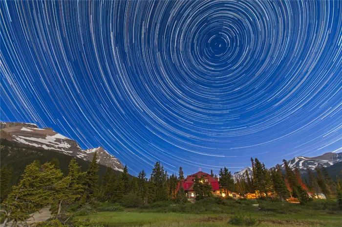
This image was captured using a camera set to a long exposure, allowing the stars in the night sky to create a beautiful arc. It is fascinating to observe how all the stars revolve around a specific point known as the world pole. In this photo, Polaris, the star closest to the world pole, is prominently featured. The arc created by Polaris indicates the location of the world pole. This captivating photo was taken by Alan Dyer.
Another significant aspect to consider is that if you project a line from Polaris towards the horizon, it will lead you to the north. The angle between Polaris and the horizon corresponds to the exact latitude of your current position.
These distinctive characteristics have made Polaris an indispensable reference for both celestial and terrestrial navigation for countless centuries.
However, it was not always like that. In ancient times, Polaris was considered a distinct star. And in the future, Polaris will no longer serve in that capacity. Why is that?
The reason is that while the celestial poles remain fixed, they slowly shift across the constellations. You may have already deduced that the poles of our world are essentially projections of the Earth’s north pole onto the starry sky. Additionally, the Earth not only rotates on its axis but also undergoes a gradual wobbling motion, similar to a spinning volleyball tracing out a wide cone. Consequently, the celestial poles trace out an impressive circle in the sky spanning approximately 60 degrees in diameter. This process takes an extensive amount of time, up to 26,000 years! As a result, we don’t typically observe the movement of the celestial poles in our day-to-day lives.
Nevertheless, the discovery of this phenomenon took place in the presence of Christ. The credit for this discovery goes to the esteemed Greek astronomer Hipparchus, who named it the Equinoctial Transition.
Thanks to the trade winds, Polaris only became visible around 1500 years ago. Prior to that, the closest star to the world pole was Cohabitant, the second brightest star in the constellation Lesser Mocha. In approximately 2,000 years, the world pole will shift towards Gamagamakifa, and in 12,000 years, Polaris will no longer hold its position in our sky, replaced by Vegas.
Polaris holds a special place in the realm of stars and is widely known for its unique position. Exploring and pointing it out in the night sky can be an engaging activity to do with children. Although many children have heard of Polaris, they often do not know its exact location, so expanding their knowledge about it can be quite beneficial.
The elevation of Polaris above the horizon
The height of Polaris above the horizon is determined by the latitude of your location. At the equator, Polaris is right on the horizon, while at the North Pole, it is directly overhead. By measuring the angle between the horizon and Polaris, you can determine your latitude. This angle is measured in degrees.
If we place a ruler 57 cm away from our eye, with the zero point on the horizon, the height of the star, measured in minutes of angle, will correspond to the distance on the ruler, measured in centimeters.
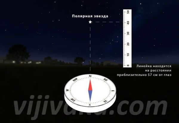
Here is an example of how to locate the polar star at the latitude of Odessa. Its approximate altitude above the horizon is 41 degrees.
However, the altitude of Polaris may differ significantly from the observer’s latitude data. In this case, the observer’s altitude can “increase” the altitude of Polaris above the horizon, while refraction can “decrease” it. These phenomena are less likely to occur near the North Pole.
How to locate Polaris using a compass
If you want to locate Polaris in the night sky using a compass, you will need to determine its two coordinates – direction and altitude.
Since the North Pole is situated in the north, it is relatively easy to find the direction using a magnetic compass, provided you have the correct self-reference (which can be found online or on a topographic map).
To do this, place the compass on a level surface, allow the needle to settle and indicate the direction. The northern part of the magnetic needle points towards the north.
For eastern self-reference, the value is set counterclockwise from the direction in which the compass is positioned; for western self-reference, the value is set clockwise. The direction in which the compass is pointing represents the geographic north pole, which is the direction to Polaris.
When observed in this direction, one of the most luminous stars in a line from the skyline to the center of the sky is Polaris.
The elevation of Polaris is determined by the latitude of the area. Utilize a specialized compass equipped with advanced features to locate the slope equivalent to the region’s latitude. In the absence of a compass, a suspended weight on a string can be utilized to determine the slope (i.e., elevation).
This provides a second set of coordinates from which the position of Polaris can be calculated relatively accurately.
You can learn more about locating Polaris using a protractor and ruler in a separate article….
Another important point. When Polaris is deflected towards the horizon, it will appear in the north. The angle between Polaris and the horizon is equal to the precise latitude of your location.
Using a compass and map
The night sky may not always be fully visible due to obstructions such as trees, hills, or clouds. In order to locate Polaris, a map and compass can be used (Figure 4).
It’s important to note that the needle of the magnetic compass should align approximately with the direction of Polaris. This compensates for any distortions caused by the magnetic poles and magnetic field lines. This phenomenon, known as magnetic field deflection, is explained in specialized reference books.
To determine the position of the North Star using a compass, follow these steps: a. Use the compass to determine the direction of the North Star. b. Use the compass to determine the direction of the North Star.
- When taking measurements, it is crucial to select a suitable location. Avoid conducting research near power lines, vehicles, or railroads, as they have the potential to distort the readings.
- To ensure precise orientation, it is necessary to ascertain the luminary’s altitude, which is measured in degrees and roughly corresponds to the terrain’s latitude. This approach enables a more precise determination of the observer’s location coordinates.
All of these orienteering techniques are considered advanced and can provide highly accurate directional information, although they are not entirely infallible.
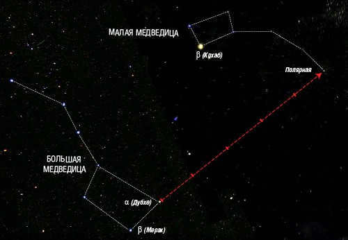
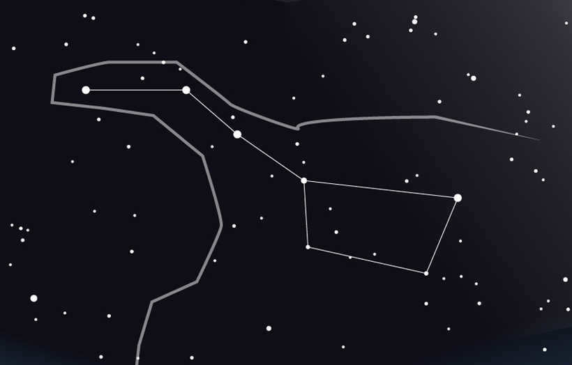
Locating Polaris in the Sky with the Help of Cassiopeia
While the Big Dipper is a convenient guide for finding Polaris in the sky, there are also alternative methods to locate this star using different constellations (Fig. 5).
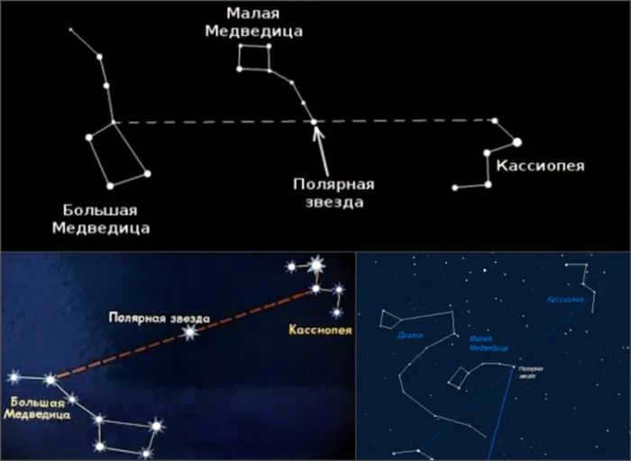
Another well-known group of stars, Cassiopeia, can be used to determine the direction of the North Star. It is located on the opposite side of the Big Dipper. In fact, Polaris is situated between Ursa Major and Cassiopeia, making it relatively easy to locate.
To find Polaris, you can follow these steps:
- Draw a straight line between the two outer points of the Big Dipper.
- Repeat the same process with the stars on the opposite side of the constellation.
- From the intersection of these two lines, draw a line through the middle of Cassiopeia. This will point you in the direction of Polaris.
When the sky is clear, it is easy to locate the primary everlasting bright stars in the northern part of the world. Locate the constellation Cassiopeia and draw a line from its center that is the same length as the distance between the two polar magnitudes of the constellation. If you have followed the instructions accurately, you will certainly find Polaris.
This largely depends on the specific geographical coordinates of the observation point. For instance, during the summer near the equator, the “big dipper” is above the horizon and cannot be seen by the naked eye. However, the constellations of Cassiopeia and Polaris can still be seen, so finding them using the above-mentioned methods is not challenging.
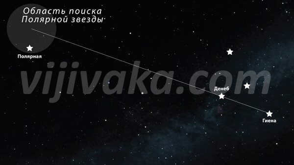
Guidance Using the Cygnus Constellation
The technique of locating Polaris through the bird’s nest method is widely regarded as highly efficient, although it is not without its challenges. One of the main obstacles is that not everyone is able to immediately identify the swan constellation in the night sky. Nevertheless, with a clear understanding of the precise steps involved, determining the direction of north becomes relatively straightforward, even in instances where portions of the sky and Polaris are obscured by cloud cover (Fig. 6).
In order to accomplish this task, it is crucial to locate the two lowest points of the constellation – Hyena and Deneb. A visual connection needs to be established between them. Deneb should trace a line that corresponds to the distance between these two celestial bodies. At the end of this line lies the most luminous point in the northern hemisphere.
Last year, I was invited by friends to visit their village, and one evening we decided to venture into the forest to pick strawberries. Unfortunately, the pursuit of berries ended up being my downfall – I got separated from my friends and found myself alone in the dark forest. I vaguely remembered that my home was somewhere in the north, but I was without a compass or a fully charged mobile phone. If I hadn’t known how to locate Polaris and navigate using it, I would have had to spend the night exposed to the chilly ground.
Guide to Locating Polaris
One way to find Polaris, also known as the North Star, is to follow these simple steps:
- Direct your gaze towards the heavens.
- Individually examine each luminous celestial body.
- In the event that you encounter any star situated adjacent to the constellation known as the Little Dipper, which bears a resemblance to a small ladle, then you have successfully identified Polaris.
There is also a quicker and more dependable method. Typically, in our region, the simplest approach to locate the Big Bear, not the Little Bear. Its stars shine much more brightly – and are immediately noticeable. The Big Dipper is also somewhat similar to a ladle, but larger in size.
So, what should we do if we come across it, but not the Little Bear? We must exercise a bit of creativity!
- The initial step you need to take is to examine the large ladle.
- On one side, there is a handle. On the opposite side, there is a cluster of stars.
- Attempt to mentally connect them with a straight line. Naturally, this requires some imagination, but it is not overly challenging.
- In your mind, you must enlarge the resulting segment by a factor of six (or slightly smaller). The key is to maintain a straight line without any bends.
- You will come across a bright star located in the handle of the Little Dipper.
If that’s the case, you have accomplished your goal of discovering Polaris. You have successfully located Polaris.
Guide to Finding Your Way Using Polaris
In the northern hemisphere, Polaris will always indicate the direction north.
Therefore, if you see this star directly in front of you:
This convenient characteristic will consistently assist you in navigating your way back home.
Did you know these fascinating details about the polar star?
Did you ever wonder that in the past, Polaris didn’t shine as brightly as it does now? Nevertheless, researchers have provided evidence that the star’s luminosity is considerably more apparent in recent times than it was in previous eras.

And this small star moves significantly less than the rest of the stars in the celestial sphere. Hence, it is commonly referred to as the “tethered horse”. Its beauty is truly remarkable.

As a child, after reading about navigating by the stars in a book, I became determined to find my way home using the night sky. Unfortunately, my efforts only led me to a tree in my neighbor’s yard, resulting in a bump on my forehead that made me resemble a goat for a week. However, my perseverance paid off when my father taught me the method to locate Polaris, which serves as a prominent guide in the sky.
Techniques for Locating Polaris in the Night Sky.
Interestingly enough, I discover it to be more convenient to locate this celestial body using the Cassiopeia constellation. Allow me to provide you with a detailed explanation on how to achieve this.
- To determine the location of the North Star, first you must observe the sky.
- You should locate the constellation Cassiopeia, which resembles the letter “M” with the side sticks spread wide apart.
- Next, draw a line connecting the three brightest stars of Cassiopeia and extend a perpendicular line from it.
- This perpendicular line should be four times the length of the Cassiopeia constellation, and it should intersect with the North Star.
Shining, but not the most shining.
Initially, my search was hindered by a common error. Somehow, it is widely believed that Polaris is the most shining star. And if that were true – finding it would be simple – it would be easier to identify the most shining star in the sky.
However, in reality, there are many stars much more shining – Sirius, for instance. It is frequently mistaken for Polaris. So don’t fall for this misconception – and instead, try the method I explained.
A traveler’s guide to the North.
Throughout history, Polaris has served as a reliable navigational tool for travelers embarking on long voyages in our hemisphere. Its constant presence in the northern sky has made it a trusted beacon for those seeking direction. Regardless of the season, Polaris remains relatively stationary, making it an ideal compass for navigation purposes.
However, when you are at the South Pole, the practice of using Polaris as a reference point can be deceiving. This is because Polaris is not visible from every location. While you can still spot the star if you are near the equator, it becomes increasingly difficult to see as you move further south.
Therefore, we are fortunate to have a guiding light right above us during the night.

Living in my quaint little town, the sky never fails to captivate me, especially during the late summer months. Whenever I gaze up at it, it serves as a constant reminder of just how minuscule and distant our planet is amidst the vastness of the cosmos. Amongst the dazzling array of celestial objects that adorn the night sky, Polaris shines as one of the brightest, easily discernible even without the aid of telescopic devices. Due to Earth’s axis pointing directly towards it, Polaris remains stationary, while all other celestial bodies gracefully orbit around it. Consequently, it only takes a single memorization of its position to ensure its swift discovery time and time again.
How to locate Polaris
Polaris is always pointing towards the North, making it a better tool for navigation than any compass or navigator. It is easy to find as it is located in the constellation of Ursa Minor. If you spot the brightest object in this constellation, you can be certain that you are looking directly at the guiding star. By the way, this celestial body is larger than our Sun, which is why it is so easily visible from such a great distance. It would take approximately 400 years to travel the vast expanse of the universe at the speed of light, and Polaris marks the outermost point in the handle of Ursa Minor.
Curious Information
Despite being referred to as the most luminous star in the night sky, this claim is inaccurate as there are at least three celestial entities that surpass it in brightness. These include:
Therefore, it would be more appropriate to label it as the brightest star within its constellation. Equally fascinating is the revelation that it belongs to the F spectral class of supergiants, implying that if one were to approach Polaris closely enough, its immense size would undoubtedly astound them.
When comparing Alpha Minor Bear to the Sun, it is noteworthy that the star’s luminosity is significantly higher, by several thousand times. However, the surface temperature is slightly lower. Furthermore, the star is currently experiencing a significant transformation, as it was about 12 to 15% less bright just a century ago.
When I initially started reading an astronomy manual, I was immediately captivated by the vastness of the cosmos. As I delved deeper into its pages, I uncovered a whole new world that was waiting to be explored. It was during my preparations for the astronomy Olympiad that I truly began to appreciate the intricacies of the starry sky. Interestingly, this subject was only introduced to us in the 11th grade, yet the mental competition began a year earlier. Throughout my studies, I gained a wealth of knowledge about the celestial sphere, with a particular focus on Polaris.

What is Polaris?
Interestingly enough, Polaris is a unique star. However, what sets it apart from the rest?
1. Polaris resides in the constellation Ursa Minor..
2. It’s situated near the North Pole of the Earth..
3. Due to its positioning, Polaris can serve as a guide to Earth’s northernmost point..
If someone is unfamiliar with this, they may encounter challenges. However, in actuality, it is quite simple. During our academic years, we were instructed to use a celestial map with Polaris located at the center. This is an ideal starting point for learning how to locate Polaris within the constellation of the Big Dipper.
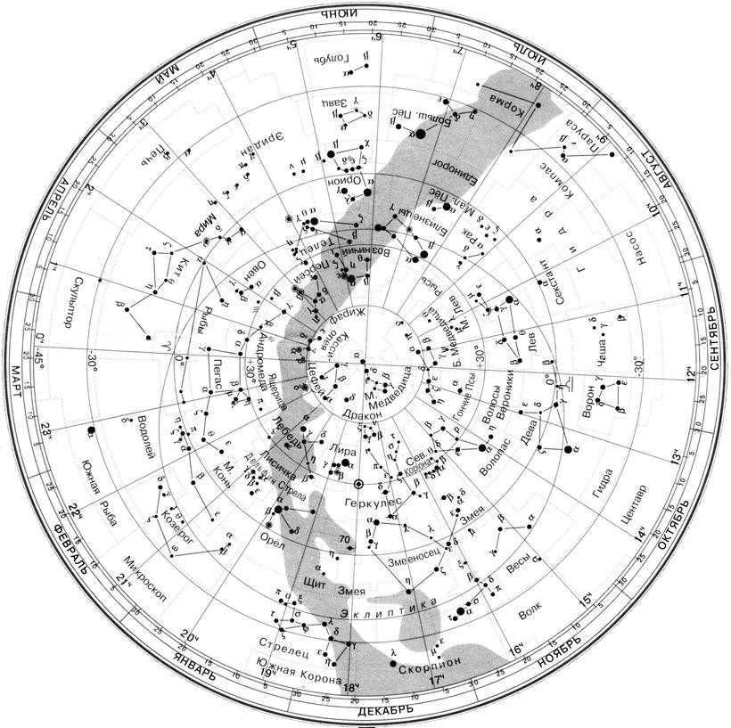
So, here are the steps for locating Polaris:
1. We are all familiar with the Big Dipper, which resembles a large ladle. It is easily identifiable in the night sky.
2. Locate the brightest stars in the Big Dipper that are aligned in a straight line.
3. Visualize a straight line extending from those stars.
4. This line will lead us directly to Polaris.
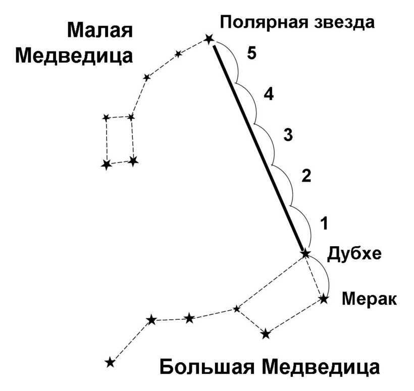
The advantages of the knowledge acquired
Presently, the Polaris serves as a valuable tool, just like a compass. Surely, one can utilize it for navigating through unfamiliar landscapes, as it consistently points towards the north. However, nowadays it is more convenient to rely on technology, such as saying, “Okay, Google! How can I reach my destination?”. Nevertheless, possessing this newfound knowledge will always allow you to impress a gathering of friends.

Here’s a piece of advice for the gentlemen out there. Unsure of where to take ♪ your ♪ ♪ Girlfriend ♪? ♪ Why not invite her ♪ for a romantic stroll ♪ in a park ♪ on a starlit night ♪ and share some knowledge ♪ about the stars ♪. Girls are attracted to intelligent and romantic guys. By the way, this idea has been around for a while. Quite some time ago.))).
I have a great fascination with stargazing. The celestial heavens inspire me, evoking various thoughts, nostalgic memories, and fanciful dreams. I am even able to identify certain constellations, including the North Star..

Navigation using celestial bodies
In ancient times, celestial bodies served as the sole reliable point of reference for travelers. However, in the modern world, few possess the knowledge of star positioning in the sky, as it is no longer a practical skill. Many believe that there is no need to burden oneself with unnecessary information when smartphones with built-in navigation systems are readily available. However, have you ever considered the scenario where you find yourself lost in a forest with a drained phone battery? In such a situation, you would have to rely solely on your own knowledge and abilities.
How to locate Polaris
Polaris can be found in the Northern Hemisphere and is visible in the sky all year round and throughout the night. To easily locate it, start by searching for the Big Dipper constellation. This constellation resembles a ladle consisting of seven brilliant stars. Close by, you will find the Little Bear constellation, which has Polaris located in its tail.
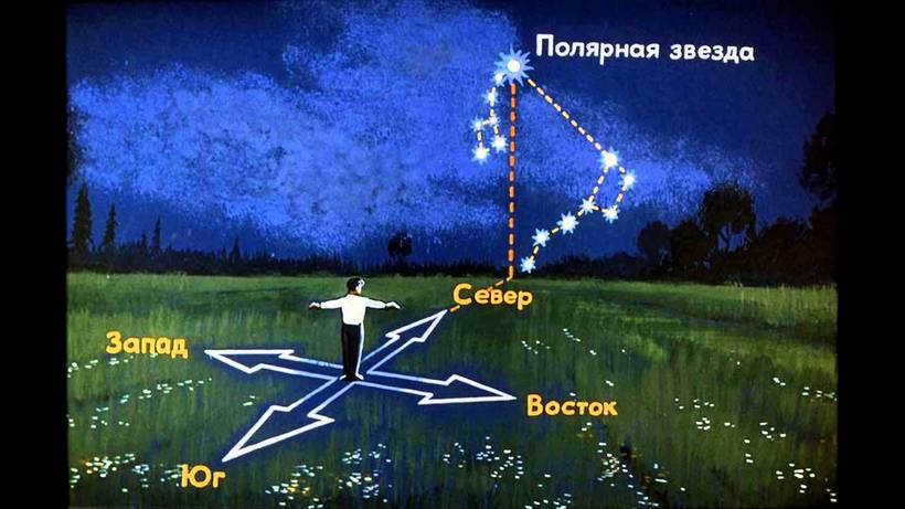
On occasion (this happens very infrequently), the Great Bear cannot be seen. In that case, you may consider using an alternative constellation, Cassiopeia, which has a shape resembling the letter “M”.. By mentally connecting the three brightest stars in Cassiopeia and drawing a perpendicular line from the center of this segment, you will find Polaris at a distance four times the width of the constellation.
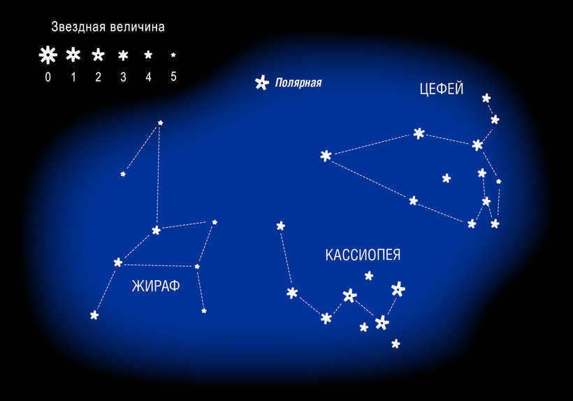
Distinctive Features of Polaris
There are several noteworthy characteristics that distinguish Polaris. Allow me to highlight the most significant ones, in my personal opinion:
- Polaris is a variable star. It emits pulsating light, with a pulsation period of approximately four days.
- Polaris is a supergiant. It is 23 times larger than the sun!
- The precise distance from Earth remains unknown. However, it is estimated to be approximately 434 light-years away.
- Polaris is a highly ancient star that is currently in a state of decline.
During my childhood, I had the fortunate opportunity to go camping on numerous occasions. My grandfather, despite being quite elderly, possessed an abundance of energy and was incredibly knowledgeable, capable of explaining any concept in a clear and understandable manner. On a particular day, while sitting around a campfire in the midst of the forest, he initiated a lesson on astronomy, teaching me how to locate the polar “pointer.”

What is it?
It is in fact a system of three stars consisting of a supergiant star at its center. This system is known as Polar Alpha. In 2012, a space telescope with high resolution determined that the distance between this star and our planet is 324 light-years. 324 light years..
This particular star is located just 1 degree away from the Earth’s North Pole and falls into the category of stars that never set, commonly known as non-sunsetting stars. It remains visible above the horizon throughout the entire year. In terms of mass, this celestial body is six times more massive than our own Sun. However, due to its immense distance from us, it appears as a tiny speck of light. Over the centuries, this star has served as a reliable guide for travelers and has proven invaluable for numerous expeditions. In Ancient Greece, it was given the name Kinosura, which translates to “dog’s tail,” as well as being associated with the constellation we now refer to as the Little Dipper. Locating this star is a straightforward task, as it can be found by following the pattern of the Big Dipper.
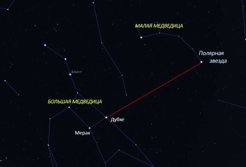
Different Polar Stars
Regarding our planet, there is no doubt – the equivalent of our Polaris. Polaris. in the northern hemisphere. is the constellation Ursa Minor. to assist navigators in the north. However, what about the other celestial bodies. within the solar system? On other celestial bodies, such as the moon. such as the moon. it is also possible to rely on their local stars:
- Delta of Goldfish serves as a guide to the southern region when observing The Moon;
- Venus will indicate the south pole using the Goldfish Eta, and the north pole using the 42nd Dragon;
- Omicron of the Dragon points to the north, while Alpha of the Painter points to the south when observing Mercury.


