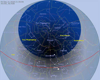

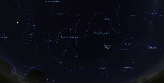
Figure 1: The winter constellations and the region where the stars do not set in the sky over Chelyabinsk.
This presented map illustrates the night sky with its current configuration based on the specified time and geographic coordinates. It also provides the ability to adjust both the date and coordinates to get accurate results.
The central point of Chelyabinsk is considered to be the location in front of the Lenin monument on Revolution Square. The coordinates of this point on the star map are approximately 55.16° north latitude and 61.40° east longitude (55°09'33" N, 61°24'09" E).
It is important to note that the local time in Chelyabinsk is different from the Moscow time, which is based on the Greenwich meridian. On average, there is a 1 hour 5 minute difference, and compared to the local zonal time, there is a 55 minute difference. Additionally, please be aware that the calculations for the starry sky are based on the time set on your device.
Figure 1 displays the winter starry sky and the constellations that never set at the latitude of Chelyabinsk. There are 5 constellations in this area that are always visible within its boundaries:
Little Bear, Dragon, Cassiopeia, Giraffe, and Cepheus. These constellations are referred to as the non-setting constellations.
Regardless of their position on the star map (Fig.2), these constellations always remain visible.
Online celestial observatory
Fig.2. Chart of the celestial sky above Chelyabinsk – for a closer look at the chart, simply click on the “Expand” symbol located in the top right corner. Additionally, you have the ability to modify the time and geographical coordinates of the region by selecting the appropriate options found in the top left corner of the chart.
To activate the live mode, tap on the sky image to activate the cross-shaped cursor, then change your keyboard to the Latin font, press the “8” key to set the current time, and finally press the “l” key (lowercase L). Please note that enabling live mode on your mobile device may drain your battery quickly.
Constellations that do not appear in the middle and subtropical latitudes form a small, compact group, so there is no need to determine their order.
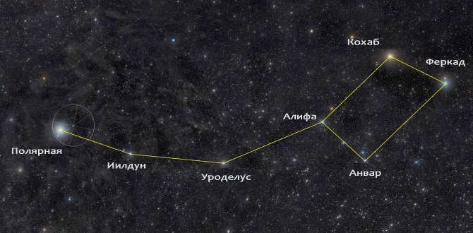
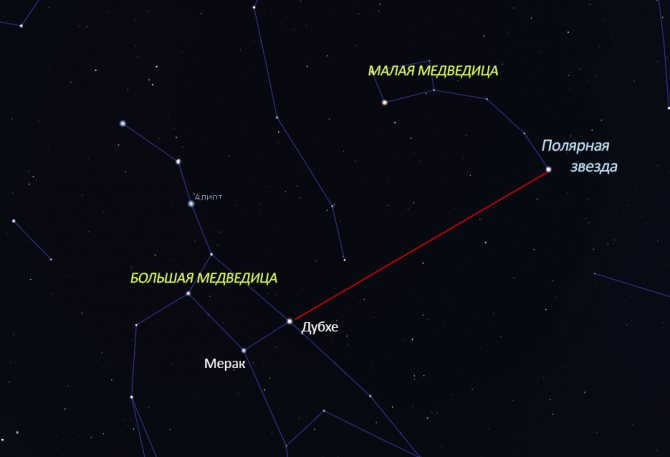
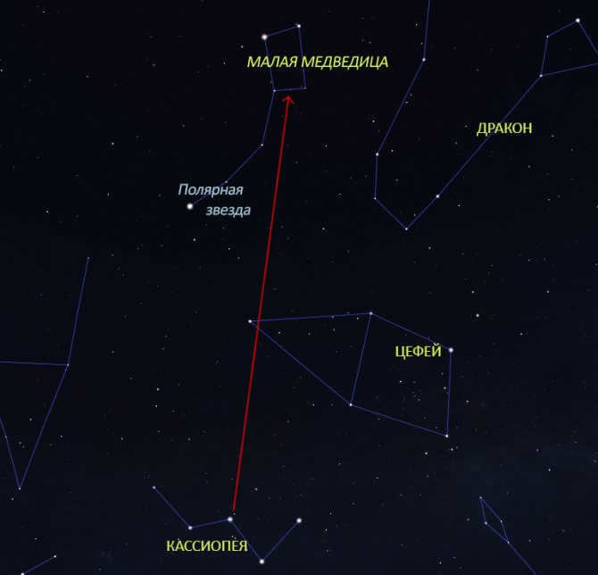
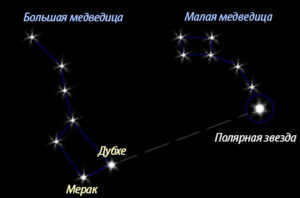
However, in groups that include a large number of constellations, it is advisable for observers to list them based on their proximity, in a counterclockwise order along the plane of the celestial equator. In this case, the most convenient reference line is not the zero meridian, but the line that passes through Polaris, Dubhe, and Merak of the Big Dipper (Fig. 3) – if these stars are difficult to distinguish due to atmospheric conditions, then it will be impossible to see anything else in such a sky, except for the Moon.
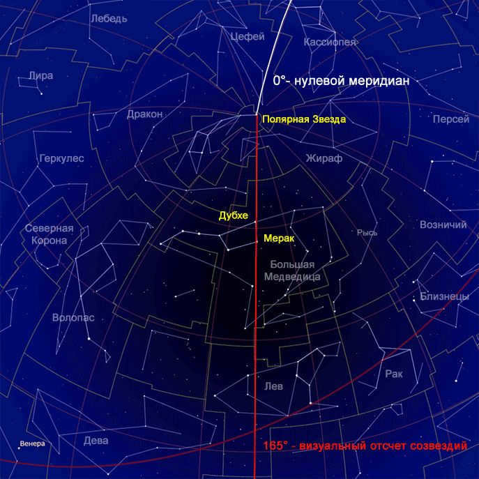
Figure 3: The night sky filled with stars, featuring the prime meridian (depicted in white) and the line that marks the beginning of visual counting of constellations (shown in red). This line serves as an excellent guide for locating Polaris and the Little Dipper.
Continuing southward, you will encounter the constellations that adorn the night sky, all of which fall within the approved boundaries set by the International Astronomical Union.
As you move past Chelyabinsk, you will come across 27 such constellations in the following order:
1. Leo;
2. Sextant;
3. Cup;
4. Virgo;
5. Raven;
6. Veronica’s hair;
7. Libra;
8. Snake-1;
9. Serpentine;
10. Shield;
11. Eagle;
12. Arrow;
13. Fox;
14. Capricorn;
15. Dolphin;
16. Aquarius;
17. M. Horse;
18. Pisces;
19. Whale;
20. Aries;
21. Taurus;
22. Orion;
23. Hare;
24. Unicorn;
25. Big Dog;
26. M. Dog;
27. Cancer.
And there are partially visible constellations at the very bottom of the sky, some of which have a star that occasionally emerges from behind the horizon.
Throughout the year, you can observe 15 partially visible constellations in the starry sky of Chelyabinsk:
1. Hydra;
2. Compass;
3. Pump;
4. Centaurus;
5. Wolf;
6. Scorpion;
7. Sagittarius;
8. Microscope;
9. Southern Fish;
10. Eridanus;
11. Furnace;
12. Sculptor;
13. Chisel;
14. Dove;
15. Feed.
In total, there are stars from 63 constellations that can be found in the sky of Chelyabinsk! The most convenient way to check for the presence or absence of constellations is to use an alphabetical list. So, here is an alphabetical list of constellations that are visible in the sky of Chelyabinsk:
Andromeda, Gemini, Big Dipper, Big Dog, Libra, Aquarius, Ascendant, Wolf, Volopassus, Veronica’s Hair, Raven, Hercules, Hydra, Dove, Hound Dogs, Virgo, Dolphin, Dragon, Unicorn, Giraffe, Hare, Serpent, Snake, Cassiopeia, Whale, Capricorn, Compass, Corma, Swan, Lion, Lyra, Fox, M. Horse, M. Dog, Little Leo, Little Bear, Microscope, Pump, Aries, Eagle, Orion, Pegasus, Perseus, Furnace, Cancer, Incisor, Pisces, Lynx, North Crown, Sextant, Scorpio, Sculptor, Arrow, Sagittarius, Taurus, Triangle, Centaurus, Cepheus, Bowl, Shield, Eridanus, South Fish, Lizard
One interesting feature of the night sky in Chelyabinsk is the collection of constellations that can be seen directly overhead at midnight. This is considered the optimal time for visual observation. Some of the constellations that can be observed in this position include Andromeda, Gemini, the Big Dipper, the Big Dog, Libra, Aquarius, the Ascendant, the Wolf, Volopassus, Veronica’s Hair, the Raven, Hercules, Hydra, the Dove, the Hound Dogs, Virgo, the Dolphin, the Dragon, the Unicorn, the Giraffe, the Hare, the Serpent, the Snake, Cassiopeia, the Whale, Capricorn, the Compass, Corma, the Swan, the Lion, Lyra, the Fox, the M. Horse, the M. Dog, the Little Leo, the Little Bear, the Microscope, the Pump, Aries, the Eagle, Orion, Pegasus, Perseus, the Furnace, Cancer, the Incisor, Pisces, the Lynx, the North Crown, the Sextant, Scorpio, the Sculptor, the Arrow, Sagittarius, Taurus, the Triangle, Centaurus, Cepheus, the Bowl, the Shield, Eridanus, the South Fish, and the Lizard.
From January 29 to April 28, the Big Dipper is visible in the sky. From April 28 to July 8, you can see the Dragon constellation. The Swan constellation is visible from July 8 to August 21. From August 21 to August 24, the Cepheus constellation is in the sky. From August 24 to September 4, you can spot the Lizard constellation. The Cassiopeia constellation is visible from September 4 to October 18. From October 18 to November 12, you can see the Perseus constellation. From November 15 to December 9, the Giraffe constellation is in the sky. From December 9 to December 25, the Chariot constellation is visible. Finally, from December 25 to January 29, you can spot the Lynx constellation. A total of 10 constellations pass through the zenith.
Starry sky above Chelyabinsk
Online mini planetarium
Interactive map of the starry sky. Shows borders and names of constellations visible at the latitude of Chelyabinsk
Keyboard shortcuts to control the online map of the starry sky:
(use cursor on the map and Latin keyboard layout)
- a → toggle haze (atmospheric simulation)
- g → display horizon
- h → choose map type
- i → invert colors
- , → show ecliptic
- ; → draw meridian line
- e → show equatorial grid
- z → show azimuthal grid
- m → show galactic grid
- M → show Milky Way boundaries
- q → hide cardinal directions
- s → hide stars
- S → hide star names
- u → conceal names of celestial bodies
- p → conceal celestial bodies and the Sun
- o → display planetary orbits
- c → display constellation diagrams
- v → conceal constellation names
- b → conceal constellation boundaries
- R → display meteor shower radians
- 8 → set current time
- j → slow down the time
- k → pause time
- l → speed up the countdown
- – → go back one day
- = → go forward one day
- [ → go back one week
- ] → go forward one week
- % → rotate counterclockwise
- ‘ → rotate clockwise
- & → display dim stars
- ( → conceal dim stars
1 or ? → display this list on a celestial map
Sergey Ov (Seosnews9)
11.07. 2018 – Work on this page will continue:
Abstracts:
– Constellations crossing the zenith ✔
– Constellations, asterisms and seasons
– A panoramic map of the entire section of the night sky visible from Chelyabinsk.
* The starry sky looks similar at similar latitudes. Usually, there is a visual similarity in the sky even with a 1-2° deviation in latitude. This means that the sky in Chelyabinsk would look similar to cities such as Kurgan, Omsk, Novosibirsk, Kemerovo, Severobaikalsk, Belfast, Glasgow, Edinburgh, Copenhagen, Klaipeda, Vitebsk, Moscow, Vladimir, Cheboksary, Kazan, and Naberezhnye Chelny. To get an exact match between the virtual map and the real sky, you just need to enter the time correction or coordinates of the corresponding city in the upper left corner of the star map.
Regional star maps are available for large cities and resort areas.
Moscow: Explore the mini planetarium online to discover the map of the starry sky over Moscow.
St. Petersburg: Experience the web planetarium and explore the map of the starry sky over St. Petersburg.
Nizhny Novgorod: Discover the online planetarium and explore the starry sky map of Nizhny Novgorod.
Novosibirsk: Immerse yourself in the online planetarium and explore the starry sky map over Novosibirsk.
Yekaterinburg: Explore the web-planetarium and discover the map of the starry sky above Yekaterinburg.
Kazan: Discover the planetarium with online settings and explore the map of the starry sky over Kazan.
Krasnodar: Immerse yourself in the JavaScript planetarium and explore the starry sky map over Krasnodar.
Samara: Experience the online planetarium and explore the starry sky map over Samara.
Krasnoyarsk: Discover the JavaScript planetarium and explore the map of the starry sky over Krasnoyarsk.
Chelyabinsk: Immerse yourself in the JS planetarium and explore the map of the starry sky above Chelyabinsk.
Omsk: Explore the online calculation of constellation pattern to discover the map of the starry sky above Omsk.
Perm: Discover the online constellation mapping and explore the map of the starry sky over Perm.
Voronezh: Immerse yourself in the online constellation mapping and explore the map of the starry sky above Voronezh.
Murmansk: Explore the starry sky over Murmansk with our virtual planetarium
Vladivostok: Experience the starry sky over Vladivostok with our Java Script Planetarium
Petropavlovsk-Kamchatsky: Discover the starry sky above Petropavlovsk-Kamchatsky with our internet planetarium
Sochi: Immerse yourself in the starry sky of Sochi with our online planetarium software
Crimea: Explore the map of the starry sky over Crimea with our online planetarium.
We have plans to create pages for the following cities: Chelyabinsk, Omsk, Rostov-on-Don, Ufa, Perm, Voronezh, Volgograd, Saratov, Kaliningrad, Sevastopol, Tyumen.
We have already created pages for “Starry sky” in Chelyabinsk, Omsk, Perm, and Voronezh.
Experience the interactive map of the starry sky in any given area and at any given time:
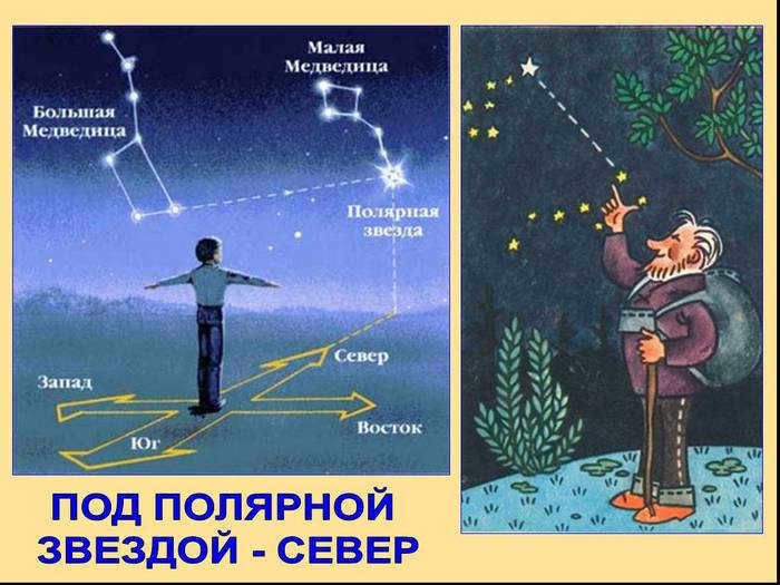
There are several ways to locate Polaris in the night sky. One of the simplest methods is to search for the constellation known as the Big Dipper and then use a compass or map to pinpoint its location. In addition, Polaris can also be found by identifying other well-known constellations such as Cassiopeia, the Swan, and Orion, which are easily distinguishable among the other celestial objects.
Many people use the position of Polaris to orient themselves in different directions, as it provides a reliable indication of the north. By facing Polaris, one can easily determine the direction of the geographic north pole, with the south being behind them.
To learn more about using Polaris for orienteering, refer to a separate article dedicated to this topic.
Typically, orienteering without a compass or GPS is considered as a last resort. In some cases, Polaris can be used to determine compass correction, as it provides a more accurate indication of north than a magnetic compass.
However, there are also situations where finding Polaris is a matter of curiosity or other purposes. In these instances, individuals usually have a compass, map, and potentially other tools to assist in this endeavor.
Polaris itself can be found in the constellation Ursa Minor, specifically in its “tail”. This constellation is not easily visible in the night sky and can be obscured by light pollution, particularly in urban areas. Therefore, auxiliary constellations that are more prominent in the night sky are often used to locate Polaris.
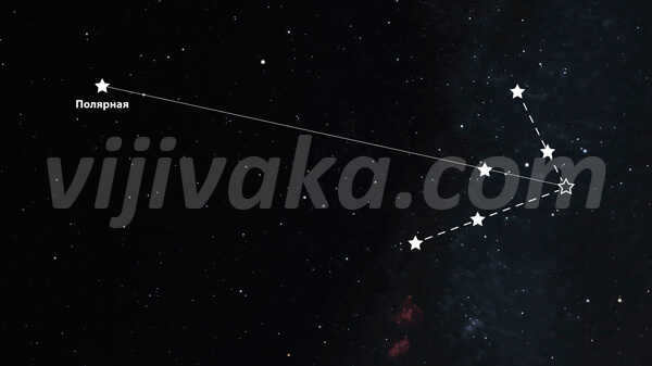
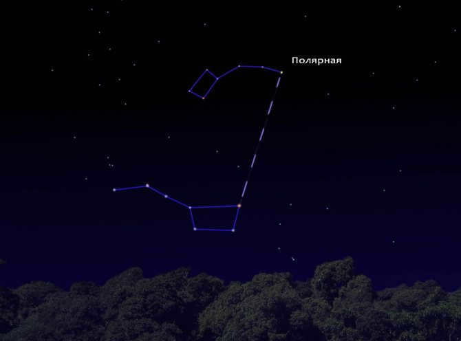
Method 1: Locating Polaris using the Big Dipper
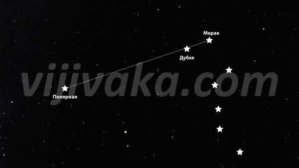
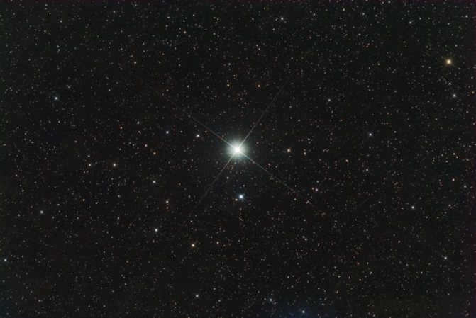
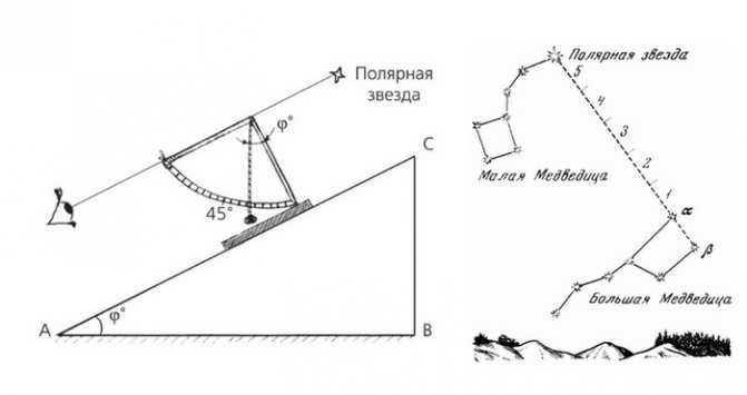
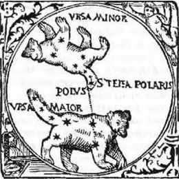
To locate Polaris using the Big Dipper, you will need to locate the constellation’s “bucket” and the two stars that form its “outer wall” opposite the “handle”. The lower star is called Merak, while the upper star is called Dubhe. Next, draw a line from Merak through Dubhe, which will outline the “wall of the bucket”. On this line, at a distance of five segments between Merak and Dubhe, you will find Polaris. Polaris stands out among nearby objects due to its brighter light.
A diagram depicting this method is overlaid on the photograph of the starry sky below:
Technique 2: Locating using a compass
To locate Polaris using a compass, you must be aware of its direction and the height at which it appears above the horizon. Generally, the magnetic needle of the compass aligns approximately with the same direction as the star, with a slight offset due to the difference between the magnetic and geographic poles, as well as the distortion of magnetic lines. This offset is known as the magnetic declination of the region and can be found in a reference book or online.
- The degree measurement of Polaris’ altitude is determined based on the observer’s location. It will be roughly equivalent to the latitude of the area where the observer is situated. To find out the latitude of your place of residence, you can use the Internet or any other convenient method. For instance, the latitude of Odessa is 40°29'10″. This means that Polaris will be seen at an altitude of approximately 40.5° from Odessa;
- By knowing the angular altitude, one can estimate the approximate position of the star in the night sky. To accomplish this, various methods can be employed, such as using a sextant, a compass with an integrated altitude feature, a protractor with a weighted string, or any other recognized technique.
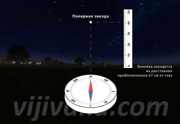
To approximately determine the location of Polaris at a given angular elevation, one can employ a ruler. To accomplish this, position the ruler vertically at a distance of 57 cm from the eyes and raise it vertically upward from the horizontal level by the same number of centimeters as the calculated angular height in degrees.
For instance, in the case of Chelyabinsk, the height of the Big Dipper is to the left of the North Star, while Cassiopeia is located to the right and down.
Approach 3: Utilizing a Map
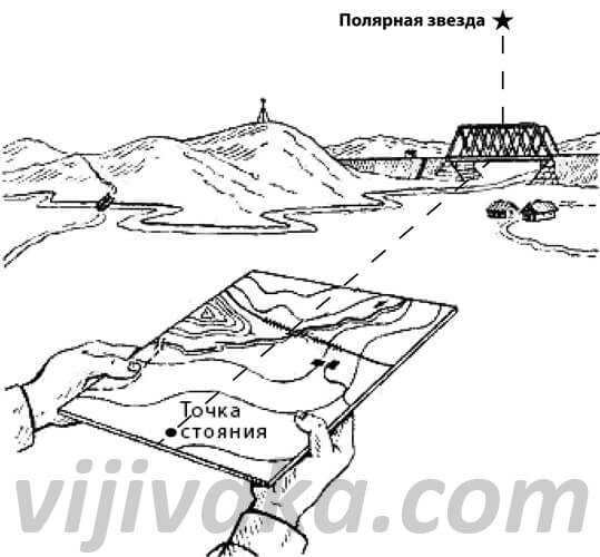
In the event that a compass is unavailable, one can rely on a detailed map to determine the direction towards Polaris. A suitable option would be a city map, which can be acquired from specialized stores or certain newspaper kiosks. It is crucial that the map is of a large scale and not a simplistic diagram or promotional leaflet.
The observer positions themselves on a straight reference point (such as a road) and then aligns the map accordingly. To achieve this, they locate a linear reference point on the map that corresponds to their current location, and then rotate the map so that the direction of the linear reference point on the map matches the direction of the same reference point on the ground. By comparing the surrounding objects on the ground and on the map, it is important to ensure that the map is correctly oriented and not rotated by 180°. In simple terms, if any object – be it a house, a park, or a body of water – is depicted on the map to the right of a linear reference point, it should indeed be situated on the right side of the observer in reality.
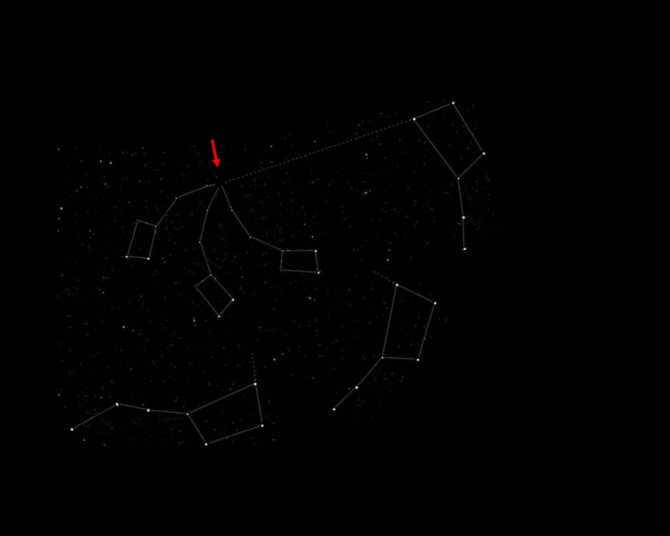
There are instances where a compass and map are not readily available, the visibility of the Big Dipper is obstructed by clouds and trees (or the observer is in close proximity to the equator during the summer-autumn season), but certain sections of the night sky with familiar constellations are still visible. These constellations can serve as a guide for navigation.
Method 4: by Cassiopeia
Cassiopeia is positioned opposite the Big Dipper, in relation to Polaris. Polarisima seems to be situated between these two constellations. As a result, it is just as simple to locate it using Cassiopeia as it is with the Big Dipper. To accomplish this, a straight line is drawn through the two furthest stars of the constellation. The same process is repeated with the two outermost stars on the opposite side of the constellation. The intersection of these two lines is then used to draw a line through the middle star of Cassiopeia. On this line, a segment equal to twice the distance between the outermost stars of Cassiopeia is marked – this marks the position of Polaris.
This approach is equally straightforward and convenient, just like using the Big Dipper to locate Polaris. In certain situations near the equator during the summer months, the Big Dipper may not be visible above the horizon, but Polaris can still be seen. In such cases, Cassiopeia can be observed as well, providing an additional reference point for finding the star with relative ease.
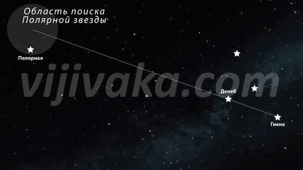
Method 5: using the constellation of Cygnus
Additionally, the position of Polaris can be established by referencing the constellation of Cygnus. To accomplish this, a line is drawn from the star Vega through Deneb. Following this line, a segment is measured that is equivalent to twice the distance between Vega and Deneb. This process allows for an approximate determination of the whereabouts of Polaris, which is home to the most prominent celestial body known as the Polarissima.
Method 6: by Orion
If the whole northern sky is cloudy, you can locate Polaris by using the constellation Orion and the star Capella. To accomplish this, draw a line from the middle star of Orion’s “belt” through the star Meissou. From Capella, measure a distance that is equal to the Meissa-Capella segment along the line. Polaris is approximately located in this region of the sky.
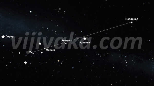
During the autumn and winter seasons, when the night sky is clear, one of the most recognizable constellations is Orion. This asterism is particularly useful for locating the North Star.
Useful tips
Remember that the Polaris star can only be seen in the northern hemisphere. In the southern hemisphere, it is visible only at a distance of up to 85 km from the equator, or under specific weather conditions when light is refracted, or when the observer is at a higher elevation.
When at the equator, where the latitude is 0°, Polaris will appear very close to the horizon. As you move further north, the star’s altitude will increase and will reach its maximum at a latitude of 90°.
There is a common misconception that Polaris is one of the most luminous stars in the nighttime sky. However, this belief is unfounded: its apparent luminosity is significantly dimmer than stars like Sirius and Canopus, as well as planets such as Venus and Jupiter, which can be mistaken for stars by the uninformed. Nevertheless, in comparison to neighboring stars, Polaris does shine with a more intense brilliance. As a result, various methods of constructing constellation lines, compasses, or maps do not require pinpoint accuracy: simply locating the general vicinity where the star is situated will already lead to the brightest point in that region.
All files can only be accessed by registered users. The registration process will only take a few minutes.
opredelenie_wiroti_po_poliarnoi_zvezde.doc (176.0 KiB, 128 hits) You do not have the authorization to download this file.
____________________________________________________________________________________________
Latitude Determination using Polaris
- Theory behind the method.
- The process of observations and calculations.
- Advantages and disadvantages of the method.
The altitude of the pole of the world above the horizon is always the same as the latitude of the location. Unfortunately, in the polar regions themselves, there are no stars that can be used to measure the latitude directly after corrections. However, near the north pole, there is a relatively bright star known as Polaris, which is part of the Little Bear constellation. The coordinates of Polaris for 2001 were 38°45′ for its latitude and 89°16′ for its longitude. Therefore, its polar distance is 90° – 1° = 44′. As a result, the altitude of Polaris is close to its latitude and may vary by a small amount x.
Assume that Polaris is located at an arbitrary point C. Let’s descend a spherical perpendicular from this point to the observer’s meridian. The value of x represents the projection of the polar distance on the observer’s meridian. Since the polar distance is small (44′), we can treat the rectangular triangle PNCD as flat. Based on the given right triangle, we have x = sosttm
The diagram indicates that =
ho – x (*)
By using
the fundamental time formula,
we can derive
x = cos(Sm – )
. By substituting the value of x into the formula (*), we obtain
= ho – cos(Sm – )
Let’s use the notations
I = – o cos(Sm – o) (**)
o and o represent the average annual values of direct ascension and polar distance of Polaris.
Ultimately, the latitude can be determined by the altitude of Polaris using the following formula
Correction I considers the daily rotation of Polaris around the North Pole of the World. This correction depends only on sidereal time and is selected from the MAE from the table “Latitude by height of Polaris” on pages 277-278.
Correction II takes into account the sphericity of the PNCD triangle and adjusts correction I. It is always positive and is chosen from the MAE from the table “Latitude by Polaris altitude” on page 279, using arguments Sm and h.
Correction III takes into account the change in the equatorial coordinates of Polaris throughout the year. It corrects correction I and is chosen from the MAE from the table “Latitude by altitude of Polaris” on page 280, using arguments Sym and date.
In order to determine latitude using the altitude of Polaris, it is necessary to calculate sidereal local time, as all corrections depend on it. This calculation is important for choosing the correct corrections I, II, and III based on this argument.
The sequence of observations and calculations.
Revise the sexan counting by making corrections and determine the observed altitude of Polaris. Then, input the “Latitude by altitude of Polaris” table in MAE with stellar local time and choose corrections I, II, and III. The following excerpts from this table display selections of corrections I, II, and III. By adding the corrections to the measured altitude, determine the surveyed latitude.
Pros and cons of the method.
Once the latitude is calculated, it can be utilized as an LP altitude, which will traverse the parallel. Observations of Polaris are derived from observations of other stars, for which the PLL elements are calculated using the traditional method. Shipbuilders can save up to 40% of computation time on Polaris – this is the advantage of employing Polaris for multiple-star OMCs.
The drawback of this approach is its limited applicability in terms of latitude. It can only be utilized in the northern hemisphere, with the most suitable latitude range being between 5°N and 65°N. In the southern hemisphere, there is no prominent circumpolar star near the south pole.
To acquire the content, including illustrations, you can opt for downloading a single file in Word format.
All the files are exclusively accessible to registered users. Registration process can be completed within a few minutes. The file you are looking for is titled opredelenie_wiroti_po_poliarnoi_zvezde.doc and has a file size of 176.0 KiB, with a total of 128 downloads. Unfortunately, you do not have the authorization to download this file.
____________________________________________________________________________________________
Share this information on your social media wall.
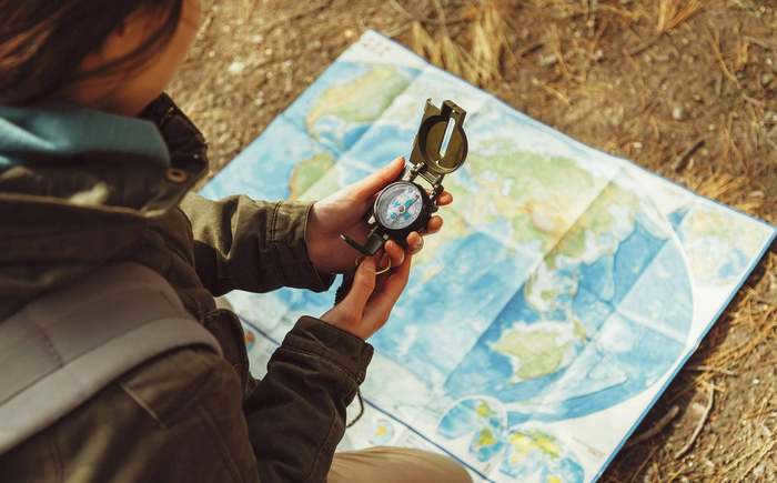
If you find yourself in a situation where evening and night are rapidly approaching and you’re stuck outdoors without a way to get home, it’s not a bad idea to search for a safe place to sleep. The simplest way to navigate is with a map, compass, or GPS navigator, but you might not have any of those tools on hand. In that case, having the ability to navigate by the stars can be quite useful.
Make sure the night sky is clear and free of clouds. Celestial objects always follow the same path. Knowing a few key details about navigating by the stars can be extremely helpful.
Using the Stars to Navigate at Sea
Navigating in the open sea and determining one’s precise position can be a challenging task. Nowadays, large ships, liners, and even small vessels are equipped with advanced navigation systems that help plot their course and provide information on deviations in degrees and minutes.
However, there have been instances throughout history where computer equipment has been attacked by viruses, leaving sailors stranded at sea for weeks until an IT specialist can come to their aid.
Long before computers were introduced on board ships, many great discoveries and voyages were made using traditional navigation methods. Vikings, Polynesians, pioneering scientists, and ordinary travelers relied on their skills in interpreting natural signs and navigating by the stars in the night sky.
For centuries, the Polynesians have been navigating the vast Pacific Ocean in their canoes, long before Christopher Columbus even set foot in America. They embarked on journeys spanning thousands of kilometers, skillfully using the natural elements as their guides – the sun, stars, moon, wind, and currents.
Incredibly, archaeologists have uncovered ancient maps created by these seafarers. These maps, crafted from shells and sticks, differ significantly from the maps we are familiar with today.
Not to be outdone, the Vikings were also renowned explorers, traversing the waters between Northern Europe, America, the British Isles, Iceland, and Greenland. They relied on their intuition, extraordinary attentiveness, and meticulous calculations. Sailing with the current, they kept a keen eye out for whales, while also employing a unique tactic of having trained ravens onboard to scout for signs of land.
Orientation was also facilitated by the use of a sundial. It enabled them to estimate the ship’s speed, keep track of the journey’s duration, and even navigate through inclement weather by utilizing the polarization of light. However, due to its inherent inaccuracies and the challenges posed by factors such as lack of wind, fog, and overcast conditions, the sundial became the subject of legends recounting instances where courageous Vikings veered off course and became disoriented.
The Clash of Longitude
The concept of utilizing coordinates to precisely ascertain one’s current location initially emerged during Ancient Greece in 200 BC. The profound musings of the most brilliant minds paved the way for the development of a precise understanding of geographic longitude and latitude between the years 100-160 AD.
Claudius Ptolemy was the originator of this theory. While his theory could enable seafarers to roughly determine their position and make necessary adjustments to their course, calculating coordinates proved to be more challenging than the scientist had initially envisioned. While latitude could be deduced from the positions of celestial bodies such as the Sun and the Moon, determining longitude was an incredibly arduous task.
In order to accomplish this task, it was essential to calculate the discrepancy between the current position’s time and a hypothetical point at the same exact moment. Initially, sailors encountered difficulties in accurately determining the precise time at their current location, and this challenge was further amplified when attempting to ascertain it at another fixed point, such as the point of departure or the Greenwich meridian. Even rough estimates were insufficient, as a mere 1-degree deviation in longitude at the equator translates to a staggering 110 kilometers.
This is quite intriguing! The conundrum of determining the time at the second fixed point remained an unsolvable quandary for such an extensive period that Louis XVI accused the French astronomers of incompetence. He believed that they were responsible for the repeated failures in uncovering new territories.
Starting from the sixteenth century, the major maritime powers of Spain, Holland, Portugal, Italy, and England were all vying to establish the most precise and reliable method of determining longitude. This resulted in a fierce competition between them. The English government even announced a grand prize of 20 thousand sterling for the discoverer. In the eighteenth century, watchmaker John Harrison introduced his remarkable invention – the chronometer – to the world and received the majority of the prize.
During this same period, another invention called the sextant was also created. This device allowed for navigation based on the position of the sun. It was the collaborative effort of several renowned scientists including Isaac Newton, John Headley, and Thomas Godfrey.
What we have today
Nowadays, sailors no longer have to perform intricate calculations as there are advanced automated navigation systems installed on board. This enables sailors to devote more time to studying their surroundings, such as weather conditions, the ship’s speed, and the topography of the seabed. Important decisions are occasionally made based on these observations. The implementation of computerization and autonomous operation has significantly enhanced the safety of navigation.
The most commonly used navigation system is the ECDIS, and if a ship decides to switch from paper charts to electronic charts, it is required to have at least two independent computers and separate displays installed.
What would happen in the event of a sudden breakdown?
Simply duplicating the navigation system does not guarantee that the computers will not experience malfunctions or failures. There are numerous factors that can contribute to this, ranging from system requirements for map updates to potential hacker attacks. As sailors navigate and operate the system, they are able to identify areas that are particularly vulnerable. Developers then work to address these weaknesses, continually creating new solutions.
In the event of a system failure, the severity of the situation depends on the proximity of the ship to land or a strait. If the ship is close to shore, the captain can request a map of the area with exact coordinates of “dangerous” zones from the shore, and sailors can also rely on smartphones for navigation. Additionally, visual landmarks can be used to aid navigation. However, if the navigation systems fail while the ship is in the open sea, far from any shore, the crew will face significant challenges.
The GPS system is not infallible: it is vulnerable to electromagnetic disturbances, and even pirates can manipulate it. They acquire a device that interferes with the traveler’s signal, causing the ship to deviate from its intended course. Despite all the sensors indicating normal operations on the ship’s dashboard, the intruders take control of the vessel and redirect it to an unknown destination.
To avoid such mishaps while navigating the open sea, various maritime academies around the world continue to instruct cadets in ancient methods of celestial navigation, using the stars, the Sun, and the Moon. This is because relying solely on GPS can lead to catastrophic consequences. The ship may collide with treacherous reefs or run aground.
Nevertheless, it is highly unlikely for a ship to become completely lost amidst numerous sea routes. Sooner or later, another vessel will appear on the horizon, prompting the distressed ship to call for assistance from a rescue team.
Getting lost can happen in almost any location. The key is to stay calm and remember the natural clues that can help you navigate the terrain, both during the day using the Sun and at night using the starry sky.
Using the Moon for Orienteering
The Moon is a satellite that orbits around the Earth, illuminated by the Sun, but it doesn’t emit light of its own. During a full moon, it is positioned highest above the horizon and can be located in the south. The shadows cast by objects point towards the north. At 7 p.m., the Moon can be found in the East, while at 7 a.m., it can be seen in the West.
If the moon is not full, it’s important to first determine its phase. This can be done by visualizing it as a letter:
- If you place your finger on the edges and observe the letter “P”, it indicates that it is undergoing waxing. It is positioned in the south from 19:00 to 20:00, and at 02:00 it shifts towards the west.
- When it ages, it takes on the shape of the letter “C” (at 2 a.m. it is in the east, and by morning (07:00) it moves towards the south).
Earth’s North Polaris is not a singular celestial body. It consists of a primary luminous object known as α Umi Aa, along with adjacent satellites α Umi B and α Umi Ab. Additionally, there are two other cosmic components, α Umi C and α Umi D, which are distantly associated with it.
The companion α Umi B, which was discovered by the English astronomer William Herschel in 1780, is included in the Little Dipper. This cluster of stars is among the most easily recognizable, just like the constellations of the Big Dipper, Cassiopeia, and Orion’s belt.
Humanity is aware of the following information:
Polaris, the most luminous star in the night sky, plays a crucial role in orienteering during nighttime. Its position is relied upon not only by travelers, but also by fishermen and hunters. In dire situations, knowing how to locate the cardinal directions using Polaris can potentially save a person’s life.
The North Pole is indicated by Polaris.
Function as the closest and brightest entity.
Without a doubt, Polaris points towards the north. “Alpha” is situated in the vicinity of an imaginary line that aligns with the Earth’s axis of rotation. It remains nearly motionless, and almost all celestial bodies in the Northern Hemisphere revolve around it. While it is possible for an object to change its visual position, this occurs infrequently. Therefore, it is the norm for the Earth’s axis and Polaris to align along the same line.
Have you ever wondered: What is the fastest planet?
The movement of the celestial body across the celestial sphere is of great significance. In the coming years, this event will be closely linked to the axial precession of our planet. According to early forecasts by scientists, after the 21st century, the Earth’s axis will shift, resulting in a change of the North Star. The new North Star will be Gamma Cepheus, expected to take its place around the 41st century. Currently, the distance from the celestial pole is approximately 1.4 lunar diameters.
How to locate Polaris in the sky
Polaris, also known as the North Star, is the brightest star in the constellation of Ursa Minor. However, it can sometimes be mistaken for another star. Therefore, the first step in finding this celestial landmark is to use the surrounding constellations as a guide. This method is known for its accuracy, as the stars within constellations are fixed relative to each other.
It is best to search for Polaris on a clear night, when the sky is free from clouds and fully visible. During this time, you can also identify the North Star by looking for nearby groups of stars that are luminous and closely positioned.
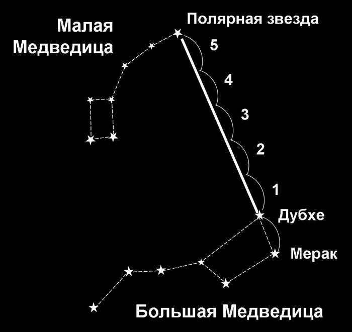
Diagram illustrating the process of locating the polar star
Using the Big Dipper
One easy and efficient method for locating Polaris at any time of the year is by using the Big Dipper constellation. Unlike the Little Dipper, the Big Dipper is more visible and recognizable, even to those with limited stargazing experience.
In the Northern Hemisphere, the Big Dipper can be seen throughout the year, but its position changes over time. During winter, it is closer to the horizon. It then moves counterclockwise towards the east, with its “tail” pointing downwards, and reaches its highest point in late spring. In summer, it moves downwards towards the west.
- Locate the Big Dipper constellation.
- Take note of the two rightmost stars in the Big Dipper.
- Imagine a straight line connecting the star Merak, located at the base of the ladle, to Dubhe, located above.
- Extend the straight line until it reaches Polaris.
Important!
When using this method to find the North Star, it is important to ensure that the line connects the Big and Little Bears precisely. The main large constellation should have a clear view of 7 stars. Beginners often mistake the real Polaris for Venus or the lone star Sirius, as they are highly visible during the process of calculation.
The constellations known as the Big and Little Bears can be used as a guide for navigation.
By using a compass and a map
It may be challenging to see the stars clearly due to weather conditions or the location of the traveler. However, if it is necessary to determine the north and other directions, orienteers can use tools such as a map and compass.
If you are using a magnetic compass instead of an electronic one, it is important to consider the influence of magnetic fields on the compass needle. Adjustments for magnetic declination should be made to ensure more accurate navigation.
The technique using a map and compass is as outlined below:
- To determine the direction towards the north, the compass is employed. It is crucial to consider the declination, which should be known beforehand. By aligning the compass arrow with the north direction, the angle is adjusted to the left if the magnetic declination is west. Conversely, if the declination is east, the angle should be adjusted to the right.
- The second step involves determining the altitude of the celestial body, which is essentially equivalent to the observer’s latitude. This enables a more precise determination of its coordinates.
- The third step entails utilizing a topographic map. The map should be oriented with the top portion indicating the north, aligned with the direction of the celestial body. This allows for the identification and marking of visible landmarks on the map.
In order to ensure accurate measurements, it is important to adhere to a fundamental principle: conducting research away from power lines or railways. Otherwise, the presence of electromagnetic waves can introduce inaccuracies into the readings.
If the sky is covered with clouds, a map and compass can assist in locating the star.
By Cassiopeia
The Polaris can also be found by identifying other groups of related stars. The method using the well-known constellation Cassiopeia is just as simple as using the Big Dipper.
Cassiopeia is situated on the opposite side of the Big Dipper. Both of these constellations are clearly visible in the night sky, along with the Guiding Star which is located between them.
Calculations using this method are based on the following steps:
- Two segments that connect the extreme points of Cassiopeia need to be visually drawn on both sides.
- Continue drawing the segments until they intersect with each other.
- From the point of intersection, draw a third straight line that passes through the middle star of the constellation.
- This line should be approximately the same length as the two segments between the extreme points of Cassiopeia, so that it aligns with Polaris.
This technique is useful for orienting oneself during summertime observations near the equator, where the Big Dipper is located below the horizon and the constellation cannot be observed.
Using the Swan’s star as a guide
Individuals with specific astronomy skills are able to locate the Cepheids on the celestial sphere by utilizing the star of the Swan. This particular method is considered challenging because the Swan star is not the brightest or most prominent luminary. Nonetheless, relying on the Swan’s star can be helpful when clouds obscure parts of the sky, including Polaris itself.
In order to conduct the search, the following steps must be taken:
- Firstly, locate the two main stars of the Swan, Deneb (Alpha of the Swan) and Gienach (Genach, Epsilon of the Swan). These luminous points serve as reference markers.
- Once the necessary stars have been identified, draw a line through them.
- From Deneb, extend this straight line, making it twice the length of the segment between the lower points of the constellation.
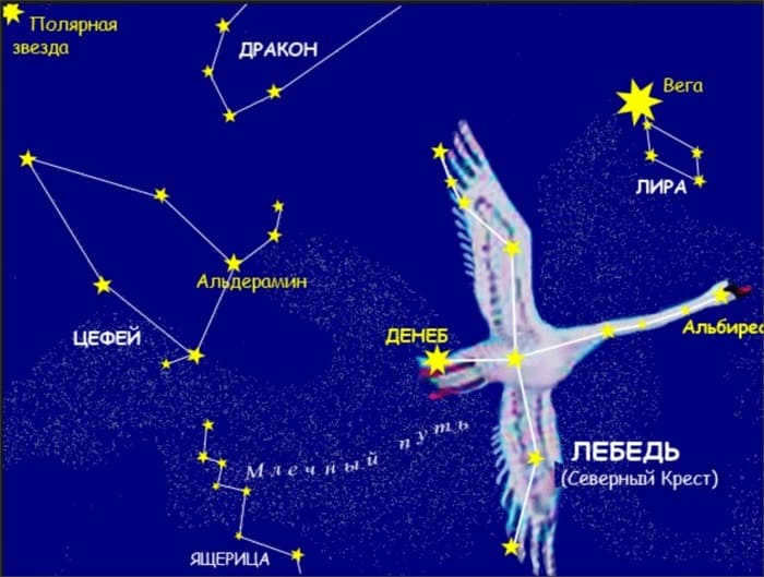
Searching for the Swan constellation can be challenging.
Orion
The method of searching by the Orion constellation is also considered complex, but it can be used with expertise in astrometric calculations. This method comes in handy when it is difficult to determine the northern direction due to clouds covering parts of the celestial map.
Here’s how to search for the Guiding Star using the Orion constellation:
- Begin by locating the Belt of Orion on the celestial sphere;
- Next, visually draw a line from the midpoint of the Belt through Meissa, which is part of the constellation;
- The resulting line should pass near the bright star Capella, which is the outermost object of Orion;
- Continue drawing the line until it intersects with the main star of the Northern Hemisphere;
- The beam’s length should be equivalent to the combined length of two equal segments, one stretching from Orion’s Belt to Capella, and the other from Capella to Polaris.
The technique of locating a reference point by means of the Orion constellation is exclusively employed during the autumn and winter seasons. Firstly, it is during this period that the stars are positioned at the precise distance required for accurate determination of the north direction. Secondly, Orion’s belt is observable solely in the Northern Hemisphere’s sky during the fall and winter.
Orienteering with Polaris and the Map
Once Polaris has been located, it can be used to orient a map. To do this, place the map on a flat surface with the top frame (representing the northern part of the map) aligned directly with Polaris. From there, all necessary calculations and orientation on the terrain can be made using the map.
For instance, you can use the outlines of mountain peaks or the direction of light from far-off cities to roughly determine your position on the map, and therefore on the terrain.
If it is not feasible to ascertain your precise location in an area with limited landmarks, then you can utilize the emergency azimuth method. In simple terms, using a protractor, you can identify an azimuth on the map that leads to a linear feature (such as a highway, railroad, or river) or an area feature (such as a large lake, reservoir, or forest clearing) that must be passed in order to stay on the correct path. Once you reach this landmark, you can reevaluate your position using the surrounding landmarks and determine the next course of action. This approach is typically sufficient for accurately determining your location and finding your way to populated areas or encountering people (which is more likely to occur along highways, railroads, and rivers) if necessary.
This is fascinating: Local clues for determining the boundaries of the skyline
The techniques outlined for navigating with Polaris are effective in the middle and lower latitudes of the northern hemisphere. However, in the higher latitudes of the north, where Polaris is almost directly overhead in the center of the sky, determining the cardinal directions becomes challenging. At the North Pole, the star is consistently near the zenith and provides minimal directional guidance.
If there is wind blowing, it is recommended to shield the plumb bob from it using a hand or some other wind screen.
The level of error in this method will increase as the observer gets closer to the North Pole, and under ideal conditions (no wind, precise positioning of the eye, thread, and needle in a straight line), the method will become ineffective at latitude 89 ° 16′.
Additionally, it is important to keep in mind that orienteering is most commonly practiced by travelers and tourists, who are primarily in high latitudes during the polar summer. During this time, it is usually bright and stars (including Polaris) are not visible in the sky. In this season, it is more practical to utilize alternative methods of orienteering.
How to Find Your Way Using the Polar Star
When a lost traveler finds themselves without modern gadgets or a compass, there’s no need to panic and forget about using natural landmarks. In northern areas, one of the most common methods of orienteering is navigating by the Polar Star.
There are several advantages to using this celestial guide to determine directions. The Polar Star, also known as Polaris, is always close to the Earth’s axis of rotation, which means its position remains relatively constant. Additionally, this star can be observed with the naked eye, meaning no special equipment is required. This makes calculating one’s position using the night sky simple and accessible to any traveler.
Polaris has saved more than a few human lives.
Heading towards the north
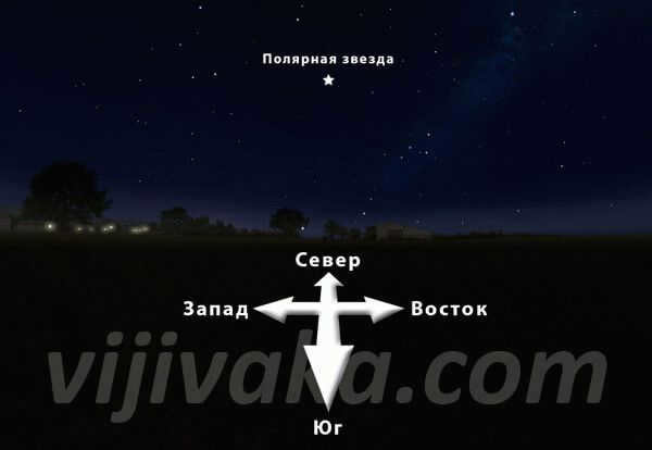
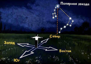
Even inexperienced travelers can determine the cardinal directions by observing Polaris. To do this, they just need to face Polaris and visualize an imaginary line that runs perpendicular to the horizon.
So, directly in front of the observer’s face is the north, and behind their back is the south. The east is located on the right side from the point where the beam intersects with the Earth’s surface, and the west is on the left.
Attention please!
This technique can provide more precise measurements compared to using a compass. However, it is not complicated to use. Keep in mind that you can only rely on the North Star as a reference point during nighttime.
Determining latitude
The North Star has an additional remarkable characteristic. By measuring its elevation above the horizon, you can determine the latitude.
Due to its close proximity to the geographic pole, this celestial object has minimal movement. However, depending on the observer’s location, it can be observed that the height of the North Star above the horizon line varies. When conducting calculations at the North Pole, the North Star will be at its zenith, while at the equator, it will appear nearly touching the horizon line. Consequently, the measured angle will correspond to the latitude of the specific location.
The navigators of ancient times possessed the skill to ascertain their latitude, measuring the elevation of celestial landmarks each night.
Measuring Latitude by Polaris
How to Determine the Directions of the Horizon Using Polaris?
If you face Polaris, you will observe the north in front of you, the south behind you, the east on your right, and the west on your left. By doing so, you can accurately determine the directions of the horizon, which is sufficient for the majority of tourists and travelers.
The image illustrates a diagram of this orientation:
Constantly checking the Polar Star is not necessary for navigating in the correct direction. On a moonlit night, simply orient yourself once using the Polar Star to determine the desired direction of travel. Then, locate a distinct landmark (such as a tall tree or mountain peak) in that direction and proceed towards it. Once you reach the landmark, position yourself behind it, reorient using the Polar Star, select a new landmark aligned with the desired direction, and continue moving towards it. The farther the landmarks are from the traveler, the more accurate the direction of travel will be.
The advantage of this method is that it allows for navigation in the correct direction even if the Polaris is obscured by clouds and tree branches in the sky or if it is obscured by fog.
The latitude of an area is typically determined using a sextant or compass, with the altitude of Polaris as a reference point. However, if these tools are not available, a protractor with a plumb line can be used. In this method, a string or fishing line is attached to the center of the protractor, with a small weight at the other end. The protractor is then turned upside down and tilted until the Pole Star aligns with a straight line passing through the protractor’s ruler and the observer’s eye. The angle α is then indicated on the protractor’s scale by the string. The altitude of Polaris above the horizon can be calculated as 90°-α.
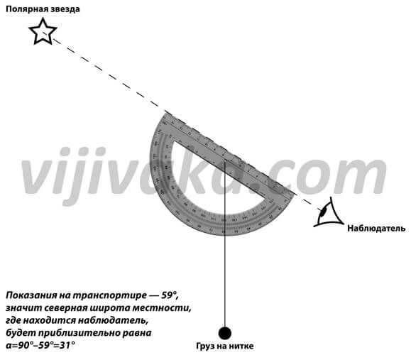
It is important to note that using this method to determine latitude will result in less precise measurements compared to those made with a sextant.
This technique is most reliable when used in the ocean or sea, although there will still be an error of slightly more than 80 km due to the distance between Polaris and the North Pole. While not particularly useful for hikers, it can be valuable for sailors or pilots who find themselves in an emergency situation: when combined with determining longitude, it can help calculate one’s exact location.
Fun fact: Acquiring licenses for non-lethal and lethal firearms
Why Polaris is renowned
When gazing at the night sky, Polaris might not immediately stand out. There is a common belief that it shines brighter or emits a different hue than other stars. However, this is a misconception about the celestial body.
Polaris is famous for other reasons. Firstly, this stellar entity is in close proximity to the geographic pole. By observing it, one can always determine the direction of north. This has allowed people to navigate accurately for centuries, even during sea voyages, without losing their way.
Secondly, while all other celestial objects complete a full revolution within 24 hours, the Guiding Star remains stationary. This can be explained by its position precisely on the line connecting the north and south poles, as well as at the center around which other luminous objects rotate on the celestial sphere.
Thirdly, because Polaris has the ability to not only provide orientation and determine the cardinal directions, but also calculate the latitude of your current location. This can be done by determining its altitude, which is the angle between the direction of the star and the horizon. The value obtained will then represent the latitude.
Throughout history, the celestial point at the pole of the world has held significant importance in the field of astronomy, and has also been highly valued by explorers and travelers around the globe. However, only individuals residing in the Northern regions are able to observe it. In the Southern hemisphere, there is no prominent landmark near the imaginary line of the pole.
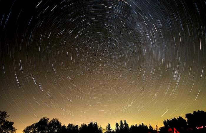
Polaris remains stationary in the sky.
Fascinating details about Polaris
Polaris is not the most luminous star in the sky
Many individuals with limited knowledge of astronomy mistakenly believe that Polaris is the most well-known and brightest star. However, this is a common misconception.
Polaris actually ranks 46th on the list of the brightest celestial bodies. As a result, it can be difficult to spot Polaris when observing the night sky in urban environments. Nevertheless, it is considered the brightest object in the constellation Ursa Minor.
The misconception about Polaris is not just because it is widely known and serves as a prominent natural landmark. One of its main distinguishing features is its stationary position, which is a result of its proximity to the Earth’s axis of rotation.
Polaris has experienced a gradual increase in brightness
It has been scientifically proven that Polaris was less bright in the past. Over the course of the last 100 years, its brightness index has actually increased by 15%.
Polaris is known by many names
In Earth’s sky, Polaris is only the Alpha of the Little Bear
This celestial body holds a unique position within Earth’s sky. Other planets have different rotation axes and inclinations to their orbits compared to Earth. As a result, each planet has a different “Polarissima” fixed at its pole.
For instance, Kinosura is also visible on Mars. However, for Mars, Kappa Sails is defined as the Polaris of the south, while at the North Pole there are two stars, Sadr and Deneb, which belong to the constellation of the Northern Cross.
The Era of the Supergiant
Currently, the Cepheid star falls into the category of supergiants, which have a relatively short lifespan. Despite their physical characteristics suggesting advanced age, these stars are not actually as old as they might seem. In reality, a Cepheid star is no more than 70-80 million years old.
Presently, the star can be observed as having a yellow hue. However, it wasn’t always a supergiant. It is likely that during its early stages, the star had a light blue color and a temperature that was three times higher than it is now.
The variability of stellar brightness occurs as a result of the transformation of hydrogen into helium, leading to the contraction of the core and the expansion of the outer shell. Consequently, the star undergoes fluctuations not only in luminosity, but also in temperature and size.
These changes are imperceptible to the naked eye. However, the pulsations of the Polaris have a precise periodicity. Currently, it is documented that the oscillations repeat every 3.97 days.
Polaris is an intriguing and extraordinary celestial object that has been extensively studied. It consists of a system of three stars, one of which exhibits specific pulsations. Additionally, its position in the sky enables navigation without the need for specialized equipment, making it possible to chart paths in unfamiliar terrains.
Did you find this information helpful? Share your thoughts in the comments!
Polaris, known as the guiding star, is the most well-known star in the sky. As the brightest star in the Little Bear constellation, it holds an important role in navigation as it always points north. Positioned near the northern celestial pole, Polaris is currently the northern Polaris. Its close proximity to the North Pole results in its near-stationary position in the nightly rotation of the stars. This makes it incredibly useful for orienting oneself, as its direction aligns with north and its height above the horizon corresponds to the geographic latitude of the observer’s location.
What is the method of locating Polaris?
Polaris remains at rest
Polaris stands out for its proximity to the North Pole, making it the closest star visible to the naked eye. This unique positioning means that Polaris remains in virtually the same spot at all times, regardless of the time of day or year. The constellations of the Big Dipper and Little Dipper, along with others, continuously revolve around Polaris in the sky. The Little Dipper’s bucket can appear both inverted and upright, depending on the observer’s perspective. It is worth noting that Polaris holds this special position only in Earth’s sky. Other planets have their own stars serving as their celestial reference points, as the axes of their rotation are inclined differently in relation to the planes of their orbits. The immobility of Polaris for over 1,500 years solidifies its status as the true navigational, agricultural, and exploratory reference point for sailors, cattle ranchers, and adventurers.
Polaris: The Brightest Star in the Little Bear Constellation
There is a widespread misconception that Polaris is an exceptionally bright star. Many individuals who are not well-versed in astronomy mistakenly believe that Polaris is not only bright but possibly the brightest star in the night sky.
However, Polaris is indeed the brightest star in the constellation of the Little Bear. With an apparent luminosity of +1.97, Polaris falls into the second magnitude category, which encompasses numerous other stars in the celestial sphere. The perception that Polaris is among the brightest stars in the Northern Hemisphere is primarily due to its unique position. Situated near the North Pole, Polaris holds significant navigational importance.
Polaris: A Guide to Navigating the Terrain
One more significant and fascinating characteristic of Polaris is its elevation above the horizon. Due to its close proximity to the Earth’s pole, our protagonist remains virtually motionless in terms of location. However, its height above the horizon can vary depending on your whereabouts! For instance, if you happen to be right at the North Pole, you will observe Polaris practically at the zenith, while if you find yourself at the equator (specifically on the hypothetical “side” of our planet), Polaris will appear almost exactly on the horizon. As a result, its elevation above the horizon aids in determining the latitude of your position. In the past, navigators would measure the angle between Polaris and the northern horizon each night to ascertain the extent of their northward or southward journey.
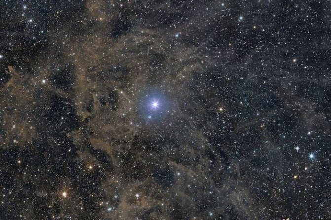
Polaris (also known as Alpha of the Little Bear (α UMi) or Kinosura) is a star with a stellar magnitude of +2.0 in the constellation of the Little Bear, which is located near the North Pole of the Earth. It is classified as a supergiant star of spectral class F7Ib. Its distance from Earth is estimated to be 434 light-years.
In 1990, the European space telescope Hipparcos determined that the distance to Polaris is 434 light-years. However, in 2012, a team of astronomers led by David Turner from Canada’s St. Mary’s University used high-resolution measurements from Russia’s six-meter BTA telescope to estimate the distance to Polaris as 99 parsecs (equivalent to 323 light-years).
The distance to Polaris, which is a type of Cepheid star, is crucial in estimating distances to other galaxies. By refining this distance measurement, scientists can improve the accuracy of the distance scale and gain insights into the mass of dark matter.
A multitude of appellations for Polaris
Fascinating facts about Polaris
- Polaris is not the most luminous star in the celestial sphere
- Polaris can be found in close proximity to the northern pole of the Earth
- Polaris holds the distinction of being the most brilliant star in the constellation of Ursa Minor.
- Polaris remains fixed in its position.
- Polaris consists of three stars
Written by: astroson.com 2017-04-23


