For over a century, scientists have been analyzing the dimensions of our planet. The ancient Greeks, including notable figures like Aristotle, Pythagoras, and Eratosthenes, attempted to calculate its size, shape, and structure. The study of the Earth has spanned centuries, with advancements in science and technology leading to a better understanding of its internal makeup. However, scientists still have more data about outer space than they do about our own planet. The Earth is composed of three layers – the core, mantle, and crust – each with its own distinct properties.
The form and dimensions of planet Earth

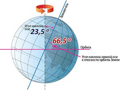
Contrary to popular belief, the Earth is not a perfect sphere. Its shape is actually known as a geoid, which is a slightly flattened sphere. The areas where the Earth is compressed are referred to as the poles. The Earth rotates around an axis that passes through the poles, completing one revolution in 24 hours, which is known as a day.
Located at the center of the Earth is the equator, an imaginary circle that divides the geoid into the Northern and Southern hemispheres.
In addition to the equator, there are meridians – circles that are perpendicular to the equator and pass through both poles. One of these meridians, which runs through the Greenwich Observatory, is known as the prime meridian. It serves as a reference point for measuring geographic longitude and determining time zones.
The main characteristics of the Earth include:
- The equatorial diameter of the Earth is 12,756 km, while the polar diameter at the poles is 12,713 km.
- The length of the equator is 40,057 km, and the length of the meridian is 40,008 km.
Therefore, our planet can be described as an elliptical shape called a geoid, which rotates on an axis that passes through the North and South poles.
The equator, a circle that divides the planet into two hemispheres, surrounds the central part of the geoid. To determine the radius of the Earth, we can use half the values of the diameter at the poles and the equator.
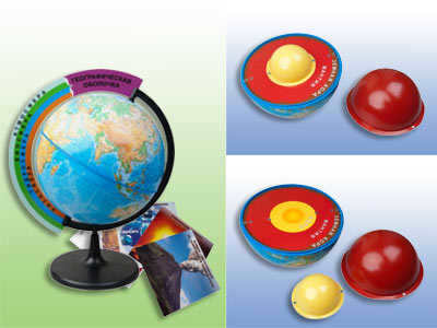
Now let’s discuss the composition of the Earth, the layers that cover it, and its internal structure.
Studying the internal mechanisms of the Earth presented a challenge for scientists. However, they were able to overcome this obstacle and delve into its mysteries. On the other hand, examining the external structure of the Earth proved to be somewhat more straightforward. The planet’s main layers are categorized based on their composition. Given that the Earth is spherical in shape, these layers, held together by gravity, are referred to as spheres. When observing the Earth’s structure in cross-section, three spheres become apparent:
Arranged in order from the surface of the planet, these spheres are:
- The lithosphere – the planet’s solid outer shell, encompassing its mineral layers.
- The hydrosphere – containing the Earth’s water resources, such as rivers, lakes, seas, and oceans.
- The atmosphere – the encompassing air shell surrounding the planet.
Furthermore, the allocation and biosphere refer to the collection of all living organisms that inhabit various shells.
[stop]Many scientists ascribe the planet’s population to a distinct expansive shell known as the anthroposphere.[/stop].
The Earth’s shells – namely the lithosphere, hydrosphere, and atmosphere – are characterized by the integration of different components. The lithosphere consists of solid rocks, soil, and the inner contents of the planet, while the hydrosphere encompasses all of its water, and the atmosphere includes the air and other gases.
Atmosphere
The atmosphere is the gaseous envelope surrounding the Earth, composed of oxygen, nitrogen, carbon dioxide, gases, and dust.
Based on the levels of oxygen, temperature, the entire atmosphere can be categorized into several primary layers:
- The troposphere is the uppermost layer of the Earth, containing the majority of the Earth’s air and extending from the surface to an altitude of 8-10 kilometers (at the poles) to 16-18 kilometers (at the equator). It is within the troposphere that clouds and various air masses are formed.
- The stratosphere is a layer where the air content is significantly lower compared to the troposphere. Its average thickness is around 39-40 kilometers. The stratosphere begins at the upper boundary of the troposphere and extends up to an altitude of approximately 50 kilometers.
- Mesosphere – a region of the atmosphere that extends from 50-60 to 80-90 km above the Earth’s surface. This layer is known for its continuous decrease in temperature.
- Thermosphere – situated approximately 200-300 km above the planet’s surface, this layer differs from the mesosphere in that the temperature increases as altitude increases.
- Exosphere – starting from the upper boundary, which lies below the thermosphere, and gradually transitioning into outer space, this layer is characterized by low air density and high solar radiation.
[warning]Within the stratosphere, at an altitude of about 20-25 km, there exists a thin ozone layer that protects all life on Earth from harmful ultraviolet rays. Without it, all life would quickly perish.[/warning]
The earth’s atmosphere is an essential component for sustaining life on our planet. It serves as a protective envelope, shielding us from the harmful effects of solar radiation and providing the air we need to breathe.
Aside from its protective role, the atmosphere also plays a significant role in regulating weather conditions, ensuring a suitable environment for living organisms. It is composed predominantly of air, with nitrogen making up around 70% of its composition, followed by oxygen at 21%, carbon dioxide at 0.4%, and other rare gases.
One crucial layer within the atmosphere is the ozone layer, located approximately 50 km above the Earth’s surface. This layer plays a vital role in filtering out harmful ultraviolet radiation from the sun, safeguarding life on our planet.
The hydrosphere encompasses all the liquid elements found on Earth.
This encompasses the location and salinity levels of water resources, including:
- The world ocean, which consists of four oceans and 63 seas and is predominantly composed of saltwater;
- The surface waters of the continents, which include freshwater and occasionally brackish bodies of water. These can be further categorized into flowing bodies of water such as rivers, and standing bodies of water such as lakes, ponds, and swamps;
- Groundwater, which refers to fresh water located beneath the Earth’s surface. The depth of these water sources can range from 1-2 meters to 100-200 meters or more.
A significant portion of fresh water exists in the form of ice, with approximately 34 million km3 of fresh water reserves present in permafrost zones as glaciers, enormous icebergs, and permanent snow that remains unmelted.
The hydrosphere is mainly responsible for providing fresh drinking water, and it also plays a significant role in shaping the climate. Water resources serve as important transportation routes and are also popular destinations for tourism and recreational activities.
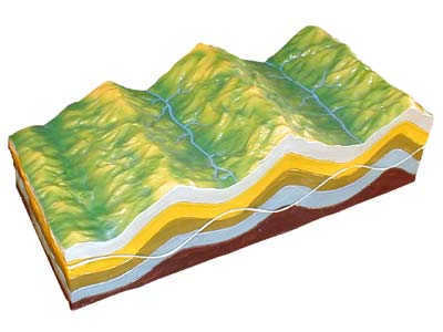
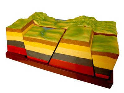
The lithosphere
The lithosphere refers to the solid (mineral) layers of the Earth. Its thickness ranges from 100 km (under the seas) to 200 km (under the continents). It is composed of the Earth’s crust and the upper part of the mantle.
Directly below the lithosphere lies the internal structure of our planet.
The internal structure of the lithosphere plate consists of basalt, sand and clay, stone, and the ground layer.
The diagram of the Earth’s internal structure, including the lithosphere, can be represented by the following layers:
- Earth’s crust – the upper layer consisting of sedimentary, basaltic, metamorphic rocks, and fertile soil. Depending on the location, it can be classified as continental or oceanic crust;
- The mantle is the Earth’s inner shell, located beneath the Earth’s crust, and it makes up approximately 67% of the planet’s total mass. This layer is about 3000 km thick. The upper part of the mantle is viscous and can be found at depths ranging from 50 to 80 km under the oceans and 200 to 300 km under the continents. The lower layers of the mantle are denser and more solid. Heavy materials like iron and nickel make up the composition of the mantle. Many natural phenomena, such as seismic activities, volcanic eruptions, and the formation of deposits, are a result of processes occurring in the mantle.
- Among a small group of scientists, in addition to the traditional model of the Earth with a partially molten dense inner core, there exists a hypothesis that at the center of the planet lies an inner source of light, surrounded by a substantial layer of water. This hypothesis, although embraced by only a small circle of experts in the scientific community who study the internal structure of the Earth, has gained significant popularity in the realm of fantasy literature. A notable example is the novel “Plutonia” by V.A. Obruchev, which recounts the expedition of Russian scientists to the cavern inside the Earth with its own miniature light source and a world populated by extinct animals and plants on the surface.
The accepted arrangement of the Earth’s internal structure, which includes the Earth’s crust, mantle, and core, is continuously being enhanced and refined with each passing year.
As research methods improve and new equipment becomes available, many aspects of the model will be updated multiple times.
For instance, determining the exact distance to the outer part of the core will require several more years of scientific research. Currently, the deepest man-made mine in the Earth’s crust reaches about 8 kilometers, so the study of the Earth’s internal structure, particularly the core, can only be done theoretically.
The Earth’s internal structure is organized in layers.
Now, let’s delve into the composition of the Earth’s layers
After exploring the internal structure of the Earth in the previous section, it becomes apparent how fascinating and intricate our planet truly is. Further examination of its structure in the future will enable humanity to unravel the mysteries of natural phenomena, enhance the accuracy of predicting catastrophic natural disasters, and unearth untapped mineral deposits.
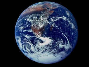
With an average distance of 149,597,890 kilometers from the Sun, Earth stands as the third planet in the solar system and possesses a remarkable set of characteristics. It came into existence approximately 4.5-4.6 billion years ago and remains the sole known planet capable of sustaining life. This remarkable ability can be attributed to various factors, including atmospheric composition and physical properties, such as the abundance of water that covers roughly 70.8% of the planet’s surface, fostering the thriving of life forms.
Earth’s Size: Mass, Volume, Circumference, and Diameter
Earth, being the largest planet in the terrestrial group, has an estimated mass of 5.9722±0.0006×10^24 kg. Its volume is also the largest among these planets, measuring 1.08321×10^18 km^3.
Moreover, our planet possesses the highest density among the terrestrial group planets due to its composition of crust, mantle, and core. The Earth’s crust is the thinnest layer, while the mantle accounts for 84% of the Earth’s volume and extends 2,900 km beneath the surface. The core is the component that contributes to Earth’s high density. It is the only planet in the terrestrial group with a liquid outer core surrounding a solid and dense inner core.
Earth has an average density of 5.514×10 g/cm^3. In comparison, Mars, the smallest of the Earth-like planets in the solar system, has only about 70% of Earth’s density.
Earth, also known as the biggest planet in the group of terrestrial planets, has the largest circumference and diameter. The Earth’s circumference at the equator measures 40,075.16 km, while it is slightly smaller at 40,008 km between the North and South poles. The diameter of the Earth at the poles is 12,713.5 km, whereas at the equator it measures 12,756.1 km. In contrast, Jupiter, the largest planet in our solar system, has a diameter of 142,984 km.
The Earth’s Shape
The Earth is not a perfect sphere, but rather a flattened spheroid or ellipsoid. This is why its circumference and diameter are different. The planet’s poles are slightly flattened, which results in a bulge at the equator. As a result, the Earth has a larger circumference and diameter at the equator compared to other latitudes.
The equatorial bulge of the Earth measures approximately 42.72 kilometers. This bulge is caused by a combination of the planet’s rotation and gravity. Gravity pulls the mass of the Earth towards its core, causing it to contract and form a sphere. However, the rotation of the Earth creates a centrifugal force that counteracts the gravitational pull, causing the equator to bulge slightly.
As our planet spins, the sphere experiences distortion due to the centrifugal force. This force is responsible for pushing objects away from the center of gravity. When Earth rotates, the highest centrifugal force is observed at the equator, resulting in a slight bulge outwards. As a result, the equatorial region has a greater circumference and diameter.
Geodesy
Geodesy, the field of study dedicated to measuring the dimensions and configuration of the Earth through surveys and mathematical calculations, plays a crucial role in the examination of our planet’s size and shape.
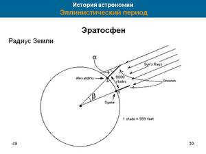
Throughout the course of history, geodesy has held significant importance, with early scientists and philosophers striving to ascertain the true nature of the Earth. Aristotle, often regarded as the first geodesist, made notable attempts to calculate the Earth’s size. Following in his footsteps, the Greek philosopher Eratosthenes estimated the Earth’s circumference to be approximately 40,233 kilometers, a measurement that aligns closely with the modern accepted value.
Additionally, consider reading: Application of phytosporin spray prior to planting
To investigate the Earth and utilize geodesy, scientists frequently make reference to the ellipsoid, geoid, and reference ellipsoid. An ellipsoid is a hypothetical scientific model that presents a polished, simplified depiction of the Earth’s exterior. It is employed to calculate distances on the surface, disregarding variables like changes in elevation and geographical features. Given the actual shape of the Earth’s surface, surveyors utilize a geoid, a model of the planet that is created using the average global sea level, thus considering differences in elevation.
Data serves as the foundation of modern geodesy, serving as a benchmark for worldwide surveys. Modern technologies like satellites and global positioning systems (GPS) enable scientists and surveyors to obtain highly precise measurements of the Earth’s surface. These measurements are so precise that they can determine the Earth’s size and shape down to centimeters, offering the most accurate data available.
The equator, derived from the Latin word “equator” meaning “to equalize,” serves as the conventional circle that divides the Earth into the northern and southern hemispheres. It also represents the longest circle, or parallel, of the Earth that is perpendicular to its axis of rotation.
Considered the starting point for determining the coordinates of any location on the planet, the equator plays a crucial role in accurately pinpointing the spatial position of various geographical objects. Without this reference line, the task of determining precise locations would be either impossible or significantly more challenging.
It is common knowledge that, for the sake of academic accuracy, the Earth is actually a geoid rather than a perfect sphere. A geoid is a body that has proportions similar to a sphere, but is not a perfect sphere. In fact, the highest point on Earth, Mount Everest, has an altitude of 8,848 meters, while the lowest point, the Mariana Trench, has an altitude of 10,994 meters relative to sea level.
Therefore, if we take into account all the differences in altitude, any calculation will pose a significant challenge. That is why, in the international community, our planet is considered a sphere for the sake of simplicity in calculations. Even the equator, which is not a perfect circle, is treated as such.
Based on the internationally recognized WGS-84 standard, the Earth boasts a radius of 6,378,137 meters. However, according to alternative standards such as IAU-1976 and IAU-2000, the Earth’s radius measures at 6,378,140 meters. This slight discrepancy of three meters can be attributed to varying approaches and methodologies used in the calculations. Nevertheless, regardless of which standard we adhere to, the Earth’s equator measures a length of 40,075 kilometers. This is because when we compute the circumference using the formula l=2πR, the difference only becomes evident in the second decimal place.
Calculations throughout history
In the distant past, during ancient Greece, Eratosthenes made initial attempts to determine the length of the equator. However, his calculations focused on measuring the radius of the Earth in the European region, which is connected to the circumference of a circle through the formula 2πR. It is important to note that during this period, there was no scientific understanding of the Earth as a planet.
The results of the calculations are even more surprising. Eratosthenes believed that the equator measured 252,000 stadia. However, due to his time spent in both Alexandria (Egypt) and Athens (Greece), it is still uncertain which measurements Eratosthenes used. If he used Greek measurements, then the radius would be 7,082 km. If he used Egyptian measurements, then the radius would be 6,287 km. Regardless of which measurement is accurate, Eratosthenes’ calculation of the radius was incredibly precise.
Also, check out: There is no activation of underground body searches.
Many European scientists adopted later efforts to determine the length of the equator. The Dutchman Snellius was the first to discuss the possibility of averaging the radius for ease of calculation. In the XVII century, he proposed calculating the radius without considering natural obstacles. France was the first country to switch to the metric system of measurement in the XVIII century. French scientists tied the standard of length to the radius of the Earth in their calculations.
The calculation was based on the length of a mathematical pendulum with a half-period of one second. This concept was revolutionary at the time. However, during his travels to southern latitudes, French cartographer Jean Richet observed an increase in the pendulum’s period of oscillation. This was due to the fact that the Earth is not perfectly spherical, but rather an oblate spheroid, causing gravity to decrease slightly near the equator.
Exploration in Russia
Exploration was also carried out within the boundaries of the Russian Empire in order to determine the configuration, distance, and additional characteristics of the Earth. One of the most significant and extensive endeavors was the Russian Arc, or Struve Arc, spearheaded by Friedrich Georg Wilhelm Struve (Vasily Yakovlevich Struve). A total of 265 triangulation points were established for measurements, resulting in 258 interconnected triangles. The arc extended over a distance of 2820 kilometers, accounting for approximately 1/14 of the Earth’s circumference. During that period, the arc spanned across the territories of Norway, Sweden, and the Russian Empire. The research was initially funded by Emperor Alexander I and subsequently by Nicholas I.
In the Soviet Union, the geodesic school also made efforts to compute the parameters of the Earth’s ellipsoid. In 1940, the calculations and adoption of Krasovsky’s ellipsoid as a standard for geodetic works in the USSR were achieved thanks to the works of A.N. Izotov and F.N. Krasovsky, defining all the key parameters of the Earth’s ellipsoid. According to Krasovsky, the accepted parameters are:
- The polar radius of the Earth is 6,356.863 km.
- The equatorial radius is 6,378.245 km.
- The length of the equator is 40,075.696 km.
- The surface area of the Earth is 510,083,058 km2.
Interesting facts
Here are some fascinating pieces of information:
- In Russia, cars cover an average distance of 40,075 kilometers within a span of two years.
- The rotational speed of the Earth at the equator is 465 meters per second, surpassing the speed of sound. This is why launching spacecraft closer to the equator is preferred. By the time the rocket is launched, it is already moving at supersonic speed in relation to the Earth, resulting in significant fuel savings.
- The only glacier at the equator can be found on the summit of the Cayamba volcano in Ecuador.
- When transitioning from the pole to the equator, objects and bodies experience a 0.53% reduction in their mass. This phenomenon is linked to the distance from the Earth’s center of mass.
- No adventurer has yet succeeded in traversing the Earth’s section of the equator.
- Within Brazil’s city of Macapa, there exists a football stadium with the equator line dividing it in half.
Video
This video will provide you with a plethora of valuable knowledge about our planet.
Equator: description, length in kilometers, Earth’s rotational speed, climate, and countries
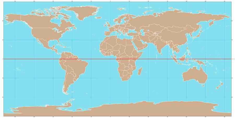
The equator is a fictional line on the surface of the Earth that extends from east to west and intersects the center of the axis between the North and South Poles (the farthest points north and south on the planet). The equator also divides the Earth into the Northern and Southern hemispheres, serving as a crucial reference line for navigation due to its latitude of 0°. All other measurements of parallels, whether north or south of the poles, are calculated in relation to the equator.
Also, check out: public lands of the power line
Being at a latitude of 0°, the Earth’s equator holds great significance in the realms of geography, navigation, and exploration. It serves as a pivotal starting point for studying various features of our planet based on their latitude. It is worth noting that the line of longitude that aligns with the equator is known as the Greenwich (zero) meridian.
Geographical Features of the Equator on Earth
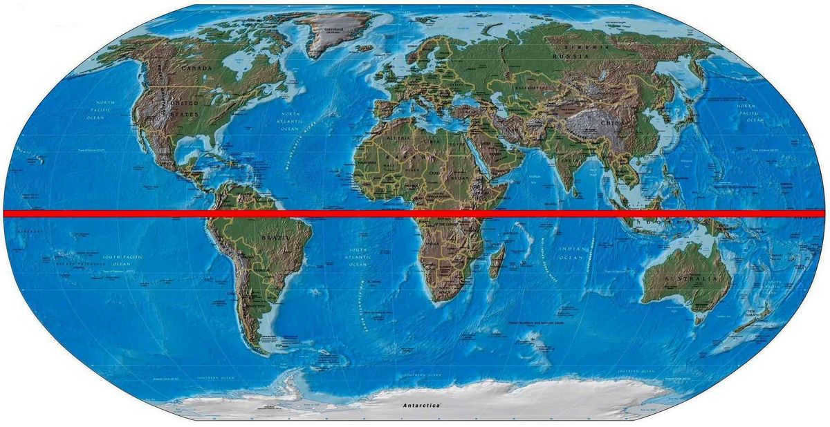
The equator is the only great circle on the Earth’s surface. A great circle is defined as any circle drawn on a sphere (or spheroid, like the Earth) whose center coincides with the center of that sphere. Therefore, the equator is considered a great circle because it passes through the center of the Earth and divides it into two equal halves. On the other hand, the other lines of latitude (parallels) that are located north and south of the equator are not great circles because they become narrower as they approach the poles and do not coincide with the center of the Earth.
Parallels are also great circles of the Earth, but due to the flattened shape of the planet, their circumference is shorter compared to that of the equator.
Due to the effects of gravity and rotation, our planet is shaped like an ellipsoid, with a slight flattening at the poles and a convexity at the equator. As a result, the equatorial diameter measures 42.7 kilometers (26.5 miles) more than the polar diameter, which is 12,713.5 kilometers (7,899.8 miles). Similarly, the Earth’s circumference is slightly larger at the equator due to the equatorial bulge. For instance, at the poles, the circumference measures 40,008 km (24,859.82 miles), while at the equator it is 40,075.16 km (24,901.55 miles).
Moreover, due to the fact that the Earth is an oblate spheroid, its rotational velocity is higher at the equator compared to other locations. This phenomenon is a result of the equator having a circumference of approximately 40,000 kilometers or 24,000 miles (for simplicity), and the Earth completing one full revolution on its axis in 24 hours. Consequently, by dividing the circumference of the Earth at the equator by 24 hours, one can determine the linear velocity of its rotation, which amounts to 1,670 kilometers (1,000 miles) per hour. As one moves further away from the equator towards the north or south, the Earth’s circumference decreases, leading to a decrease in the linear velocity of rotation as well.
The equator stands apart from the rest of the world in terms of its physical environment and geographical location. But its climate is what sets it apart the most. Throughout the year, the equator experiences consistent climate patterns, with warm, humid or warm and arid conditions prevailing. The equatorial region is also known for its high levels of humidity, which can be attributed to the intense solar radiation it receives.
As one moves away from the equator towards the north or south, the intensity of solar radiation decreases, allowing for the formation of different climate types. However, due to its tropical climate, the equatorial region is incredibly diverse. It is a habitat for a wide range of plant and animal species, and it is also home to the largest rainforests on Earth.
Countries situated on the equator
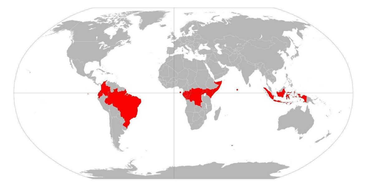
Besides dense rainforests, the equator line intersects the land and waters of 13 different countries. While some of these countries have low populations, others like Ecuador have high populations and major cities located on the Equator. For instance, Quito, the capital of Ecuador, is less than 1 km away from the Equator, and there is even a museum and monument marking this point in the center of the city.
Aside from Ecuador, the Equator line passes through the territories of the following countries: the Republic of Congo, Democratic Republic of Congo, Sao Tome and Principe (by sea near Rolache Island), Gabon, Uganda, Kenya, Somalia, Maldives (by sea between Suvadiva and Addu atolls), Indonesia, Kiribati (by sea), Colombia, and Brazil.
- New additions
- Is waterproofing the foundation of a private house necessary at all?
- Parquet – the optimal flooring choice for residential premises
- How to cut costs on building a country house
- Insulating the house with polyurethane foam and ecowool is less practical compared to polystyrene and minwool
What can you expect from lizards on your property? Many people get scared and run away when they spot lizards on their property, fearing it’s a bad sign.
What to expect from lizards on your plot? Many people get scared and run away when they spot lizards on their plot, worrying it’s a bad sign.
My eye started to hurt and itch. Looking in the mirror, you can see an unsightly bump the size of a grain. It’s a stye on the eye –
If a stye appears on the eye, common superstitions warn of danger. For instance, in your vicinity.
The Earth is positioned as the third celestial body from the sun. With regards to density, diameter, and mass, it takes the leading position among the planets that make up the Earth group. Among all the celestial bodies that have been discovered, it is unique in having an atmosphere that contains oxygen and a significant amount of water in liquid form. Furthermore, it stands alone as the only planet currently known to support life.
Brief description
The Earth is the birthplace of humanity, and while we have acquired much knowledge about this planet, there are still numerous mysteries that elude us at our current level of scientific development. Our planet is relatively small in comparison to the vastness of the Universe, with a mass of 5.9726*10 24 kg. It has a slightly oblate shape, with an average radius of 6371 km, an equatorial radius of 6378.1 km, and a polar radius of 6356.8 km. The circumference of the Earth along the equator measures approximately 40,075.017 km, while along the meridian it is approximately 40,007.86 km. The volume of the Earth is estimated to be 10.8 * 10 11 km 3.
The Sun is the central point around which the Earth rotates. Our planet moves within the ecliptic, following an orbit that was established during the early stages of the solar system’s formation. The shape of this orbit is not perfectly circular, and in January, the Earth is approximately 2.5 million km closer to the Sun compared to June. On average, the distance from the Earth to the Sun is about 149.5 million km (one astronomical unit).
The planet has an average density of 5.5 g/cm3, with the surface having an average density of about 2.2-2.5 g/cm3. The density inside the Earth increases rapidly, and its calculation is based on the period of free oscillations, moment of inertia, and momentum.
The majority of the Earth’s surface (70.8%) is covered by the world ocean, while the rest is occupied by continents and islands.
The acceleration of free fall at sea level and latitude 45° is 9.81 m/s2.
The Earth belongs to the group of earth planets, which are characterized by high density and are primarily composed of silicates and metallic iron.
In addition to the Moon, which is the Earth’s only natural satellite, there are also a significant number of artificial satellites in orbit.
Formation of planets
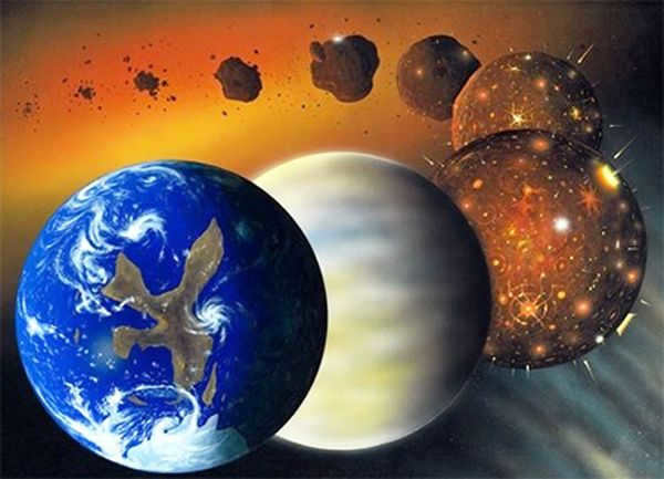
The Earth was created through the accumulation of planetesimals approximately 4.6 billion years ago. Planetesimals are tiny particles that fused together within a cloud of gas and dust. This fusion process is known as accretion. In the grand scheme of the Universe, the process of particles coming together occurred rapidly, taking only a few million years, which is considered an instant. Within 17-20 million years, the Earth had accumulated a mass similar to that of present-day Mars. Over the course of 100 million years, the Earth reached 97% of its current mass.
Initially, the Earth was in a molten and hot state as a result of intense volcanic activity and frequent collisions with other celestial bodies. As time passed, the outer layer of the planet gradually cooled and solidified, eventually forming the Earth’s crust that we observe today.
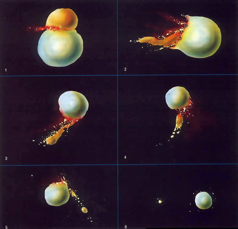
According to popular belief, the Moon came into existence as a result of a celestial body colliding with the Earth’s surface. This celestial body had a mass approximately 10% of that of the Earth. The impact caused some of the material to be ejected into the Earth’s orbit, eventually forming the Moon. The Moon formed at a distance of 60 thousand kilometers from the Earth. The impact also resulted in a significant impulse for the Earth, causing it to have a 5-hour period of revolution around its axis and a noticeable tilt of its rotation axis.
The Earth’s first atmosphere was created through degassing and volcanic activity. It is hypothesized that comets, which collided with the Earth, brought water in the form of ice and water vapor.
In the course of millions upon millions of years, the Earth’s surface underwent constant transformations, with continents emerging and splitting apart. These land masses shifted across the planet, eventually coming together to form a single supercontinent. This process occurred in a cyclical fashion. The earliest known supercontinent, Rodinia, began to break apart approximately 750 million years ago. Subsequently, from 600 to 540 million years ago, the continents coalesced to form Pannotia, and eventually Pangea, which began to fragment 180 million years ago.
As of now, our understanding of the Earth’s age and formation remains speculative, with all available information being circumstantial in nature.
The initial image captured by Explorer 6.
Noteworthy Incident
- The very first image taken from outer space was acquired in 1959 by the Explorer-6 spacecraft.
- The first individual to witness the Earth from space was Yuri Gagarin.
- In 1968, the crew of Apollo 8 observed the Earth while in lunar orbit.
- In 1972, the crew of Apollo 17 captured an image of the Earth.
The form and inner composition of the Earth
The primary method for studying the Earth’s structure is through seismology. This method involves analyzing changes in seismic wave velocity to determine the density of materials within the Earth.
The Earth is composed of distinct layers. It includes solid silicate shells, such as the crust and viscous mantle, as well as a metallic core. The outer part of the core is liquid, while the inner part is solid. This structure can be compared to that of a peach:
- The Earth’s crust is relatively thin, with an average thickness of 45 km (ranging from 5 to 70 km). It is thickest beneath large mountain ranges.
- The upper mantle (600 km) consists of a distinct layer with unique physical properties (reduced speed of seismic waves) where the material is either heated or partially molten. This layer is known as the asthenosphere and is located approximately 50-60 km beneath the oceans and 100-120 km beneath the continents.
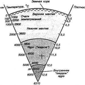
The Lithosphere refers to the part of the Earth that encompasses the crust and the upper portion of the mantle, extending down to the asthenosphere layer.
- At a depth of 660 km, there is a distinct and well-defined boundary between the upper and lower mantle. This boundary, with a thickness of 2 km, exhibits variations in wave velocity and compositional makeup.
- The lower mantle extends to a depth of 2700 – 2900 km. Thanks to the research conducted by Russian scientists, it has been suggested that the existence of a middle mantle boundary is possible within the lower mantle.
- The solid inner core of the Earth is composed of iron with nickel impurities (Fe: 85.5%; Ni: 5.20%) and is located at a depth of 5150 – 6371 km.
All the information about the Earth’s inner core is derived indirectly, as drilling to such depths has not been possible. However, these findings are supported by theoretical evidence.
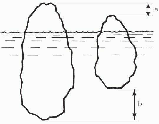
The gravitational force at any point on Earth is determined by Newtonian gravitation, although it is influenced by the distribution of density variations, which accounts for the gravitational variability. The phenomenon of isostasy, or equilibration, is also at play, where the height of a mountain is directly related to the depth of its root. An intriguing example of the isostasy effect can be seen in icebergs. However, in the North Caucasus region, this equilibration is absent, and the reasons for this phenomenon remain unknown.
Earth’s Atmosphere
The Earth is surrounded by a gas shell known as the atmosphere. It is conventionally considered to border interplanetary space at a distance of 1300 km. The official boundary of the atmosphere is defined at an altitude of 118 km, beyond which aeronautics becomes impossible.
The mass of the air in the atmosphere is estimated to be between 5.1 and 5.3 x 10^18 kg. The density of air near the sea surface is approximately 1.2 kg/m^3.
The atmosphere has two main sources:
- The evaporation of cosmic matter as it falls to Earth.
- The release of gas from the Earth’s mantle during volcanic eruptions.
As the oceans formed and the biosphere developed, the composition of the atmosphere changed through the exchange of gases with water, plants, animals, and their decomposition products in soils and swamps.
- The planetary boundary layer is the lowest layer of the Earth’s gas envelope, and its properties and characteristics are largely influenced by the interaction with the type of surface (liquid or solid). The thickness of this layer is around 1-2 km.
- The troposphere is the lower layer of the atmosphere, and it is the most extensively studied. Its thickness varies in different latitudes: in polar regions, it is around 8-10 km, in temperate latitudes, it ranges from 10-12 km, and at the equator, it extends to 16-18 km.
- The tropopause is a transitional layer between the troposphere and the stratosphere.
- The stratopause is the boundary layer that separates the stratosphere from the mesosphere. In this layer, the temperature is maintained at 0°C.
- The mesosphere starts at an altitude of 50 km and has a thickness of approximately 30-40 km. As altitude increases by 100 m, the temperature decreases by 0.25-0.3°C.
- The mesopause is a transitional layer that separates the mesosphere from the thermosphere. The temperature in this layer fluctuates around -90°C.
- The thermosphere is the uppermost layer of the atmosphere, located approximately 800 km above the Earth’s surface. As you move up to heights of 200 – 300 km, the temperature increases and reaches around 1500 K. Beyond this point, the temperature fluctuates within this range. Within the thermosphere, you can find the ionosphere region where air ionization, also known as the “polar lights,” occurs. The thickness of this layer varies depending on the level of solar activity.
- There is a specific boundary that separates the Earth’s atmosphere from outer space, known as the Karman Line. This line is located 100 km above sea level.
Hydrosphere
The hydrosphere, which encompasses all the water on Earth, holds a staggering volume of approximately 1390 million km3. As a result, it’s no wonder that the oceans alone cover 72% of the planet’s total area. These vast bodies of water play a vital role in various geological processes. In terms of mass, the hydrosphere weighs in at about 1.46*1021 kg – nearly 300 times the mass of the atmosphere, yet only a tiny fraction of the entire planet’s mass.
Within the hydrosphere, there are three main components: the oceans, groundwater, and surface water.
When it comes to depth, the Mariana Trench holds the record as the deepest point in the World Ocean, reaching an astonishing depth of 10,994 meters. On average, the ocean’s depth stands at 3,800 meters.
Although surface continental waters make up a small percentage of the overall mass of the hydrosphere, they are crucial for the terrestrial biosphere as they serve as the primary source of water for supply, irrigation, and watering. Additionally, these waters interact continuously with the atmosphere and the Earth’s crust.
The frozen state of water is referred to as the cryosphere.
The presence of water on the planet’s surface significantly influences the climate.
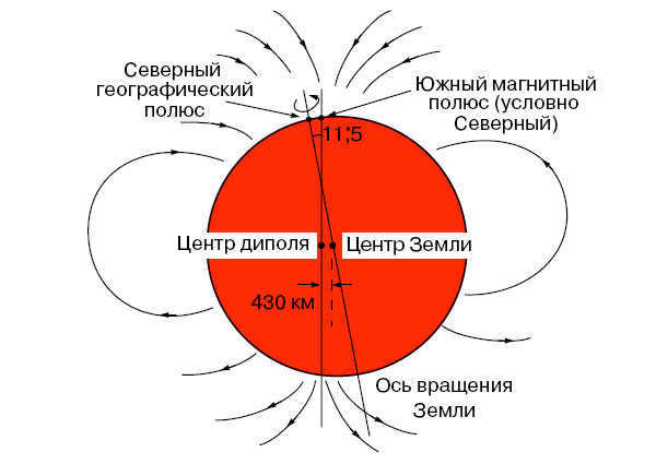
The Earth is depicted as a magnet, which is approximated by a dipole with north and south poles. The lines of force at the north pole move inward, while at the south pole they move outward. Interestingly, at the north pole (geographic), there should technically be a south pole, and vice versa at the south pole (geographic), but it was agreed upon to be the opposite. The Earth’s axis of rotation and its geographical axis do not align perfectly, resulting in a difference of about 420-430 km at the center of divergence.
The magnetic poles of the Earth are not fixed in one location; they constantly shift. At the equator, the Earth’s magnetic field has an induction of 3.05-10 -5 Tl and a magnetic moment of 7.91-10 15 Tl-m 3 . The strength of the magnetic field is relatively small compared to other magnets, such as the ones found on closet doors, which are 30 times stronger.
It was determined from the remaining magnetization that the magnetic field underwent numerous sign changes, amounting to several thousand.
The magnetosphere, created by the magnetic field, serves as a protective shield that captures dangerous solar radiation.
The source of the magnetic field is still unknown to us, and there are only theories. One theory suggests that our Earth functions as a magnetic hydrodynamo. Interestingly, Mercury does not possess a magnetic field.
The exact time of the magnetic field’s formation also remains a puzzle. It is believed to have originated around 3.5 billion years ago. However, recent discoveries of zircon minerals in Australia, dating back 4.3 billion years, have shown residual magnetization, adding to the mystery.
Curious information
Earth is a one-of-a-kind planet in our solar system, located at an average distance of 149,597,890 kilometers away from the Sun. It holds the distinction of being the third planet from the Sun and the only one known to support life. It took shape approximately 4.5-4.6 billion years ago, and since then, it has been a thriving hub of diverse life forms.
One of the key reasons why Earth is so unique is its atmospheric composition and physical characteristics. For instance, the presence of water, which covers about 70.8% of the planet’s surface, plays a crucial role in supporting life. Additionally, Earth stands out among the planets in the solar system due to its terrestrial nature. It belongs to a group of rocky planets including Mercury, Venus, Earth, and Mars, while the other planets like Jupiter, Saturn, Neptune, and Uranus are gas giants. When considering its mass, density, and diameter, Earth ranks as the fifth largest planet in the entire solar system.
Dimensions of Earth: mass, volume, circumference, and diameter
Earth, the largest planet in the terrestrial group, has an estimated mass of approximately 5.9722±0.0006×10^24 kg. Its volume is also the greatest among these planets, measuring at 1.08321×10^18 km³.
Furthermore, our planet boasts the highest density among the terrestrial group, consisting of a crust, mantle, and core. The Earth’s crust is the thinnest layer, while the mantle accounts for 84% of the Earth’s volume, extending 2900 km beneath the surface. The core is the component responsible for Earth’s high density. It is the only planet in the Earth-like group that possesses a liquid outer core surrounding a solid, dense inner core.
Earth has an average density of approximately 5.514×10 g/cm³. In comparison, Mars, the smallest of the Earth-like planets in the solar system, has a density that is only about 70% of that of Earth.
The Earth, in terms of its circumference and diameter, is also considered the largest among the planets in the Earth group. The equatorial circumference of the Earth is 40,075.16 kilometers, while it is slightly smaller between the North and South poles at 40,008 km. The Earth’s diameter at the poles measures 12,713.5 km, while at the equator it measures 12,756.1 km. In contrast, Jupiter, the largest planet in the solar system, has a diameter of 142,984 km.
The Earth’s Shape
The Earth is not a perfect sphere; it is actually a flattened spheroid or ellipsoid. This means that its circumference and diameter are different. The reason for this is that the Earth’s poles are slightly flattened, causing a bulge at the equator. As a result, the Earth has a larger circumference and diameter compared to a true sphere.
The equatorial bulge of the Earth is approximately 42.72 km. This bulge is caused by the Earth’s rotation and gravity. Gravity plays a significant role in the formation of planets and other celestial bodies. It causes them to contract and take on a spherical shape, as it pulls the entire mass of the object toward the center of gravity. In the case of the Earth, this center of gravity is located at its core.
Although local topography can influence the Earth’s shape, its impact on a global scale is minimal. The most significant variations in local topography worldwide include Mount Everest, which stands at an elevation of 8,848 meters above sea level, and the Mariana Trench, which reaches a depth of 10,994±40 meters below sea level. However, when considering the overall size of the planet, these differences are relatively insignificant. Taking into account the equatorial bulge, the highest point on Earth and the location farthest from its center is the summit of Ecuador’s Chimborazo volcano, which has an elevation of 6,267 meters and is situated close to the equator.
Geodesy
Geodesy is a scientific field that focuses on measuring the Earth’s size and shape using surveys and mathematical calculations. Its purpose is to accurately study the dimensions of our planet.
Throughout history, geodesy has played a crucial role as scientists and philosophers sought to determine the Earth’s shape. Aristotle is recognized as one of the early geodesists for his attempt to calculate the Earth’s size. Another notable figure is the Greek philosopher Eratosthenes, who estimated the Earth’s circumference to be 40,233 kilometers, a measurement that is very close to the current accepted value.
To investigate the Earth and utilize geodesy, scientists commonly make use of the ellipsoid, geoid, and reference ellipsoid. The ellipsoid is a theoretical mathematical construct that provides a simplified and smooth depiction of the Earth’s surface. It is employed to calculate distances on the surface, disregarding factors like changes in elevation and landforms. Recognizing the actual nature of the Earth’s surface, surveyors make use of the geoid, a model of the planet that is constructed based on the global mean sea level, thereby accounting for variations in elevation.
Data serves as the fundamental basis for modern geodesy, serving as a benchmark for worldwide surveying endeavors. Contemporary advancements in technology, such as satellites and global positioning systems (GPS), empower surveyors and scientists alike to achieve unparalleled precision in measuring the Earth’s surface. These technologies have become so refined that they are capable of generating data about the Earth’s surface with a level of accuracy that reaches centimeters, delivering the most meticulous measurements of the Earth’s dimensions and contours.
The term “equator” originates from the Latin word “equator” which means “to equalize”. The equator is commonly acknowledged as the imaginary line that divides the Earth into the northern and southern hemispheres, and it is the longest circle or parallel on the Earth that is perpendicular to its axis of rotation.
The equator serves as the reference point for establishing the coordinates of any location on the Earth. Without the equator, it would be impracticable to ascertain the precise spatial position of any geographical entities, or it would be exceedingly challenging.
It is common knowledge that, for academic precision, the Earth is actually a geoid rather than a perfect sphere. A geoid – A geoid is a body that shares similarities with a sphere, but is not perfectly spherical. In fact, the highest point on the planet reaches an altitude of 8,848 meters (Mount Everest), while the lowest point descends to 10,994 meters (Mariana Trench) relative to sea level.
Therefore, taking into account all the variations in altitude, any calculations would present numerous challenges. As a result, for the sake of simplicity in international calculations, our planet is considered a sphere. Even the equator is regarded as a circle, although it does not possess a perfect circular shape.
As per the WGS-84 international standard, the Earth’s radius is 6,378,137 meters. However, according to the IAU-1976 and IAU-2000 standards, the Earth’s radius is 6,378,140 meters. This slight difference of three meters can be attributed to variations in calculation methods and approaches. Nonetheless, regardless of the standard used, the equator’s length remains unchanged at 40,075 kilometers. This is because the difference in calculation only affects the second decimal place when using the formula l=2πR to calculate the circumference of a circle.
Calculation History
The earliest attempts to calculate the circumference of the Earth were made in ancient Greece by Eratosthenes. Although, in reality, he did not calculate the equator, but rather the radius of the Earth in the European region, which is related to the circumference of a circle through 2πR. During that period, the scientific understanding of the Earth as a planetary body did not yet exist.
The results of the calculations are even more surprising. Eratosthenes believed that the length of the equator was 252,000 stadia. However, due to the fact that he resided in both Alexandria (Egypt) and Athens (Greece) during his lifetime, historians and geographers are still uncertain about which measurements Eratosthenes used in his calculations. If he used Greek measurements, then the radius would be 7,082 km, but if he used Egyptian measurements, then the radius would be 6,287 km. Regardless of which measurement is considered, Eratosthenes’ calculation of the radius was incredibly accurate.
Many European scientists later adopted subsequent efforts to determine the length of the equator. The Dutchman Snellius was the first to suggest averaging the radius for easier calculations. In the seventeenth century, he proposed calculating the radius without considering natural obstacles. In the eighteenth century, France became the first country to transition to the metric system of measurement. French scientists relied on the Earth’s radius when determining the standard length.
The calculation was based on the length of a mathematical pendulum, with a half-period of one second. This concept was revolutionary at the time. However, during his travels to the southern latitudes, French cartographer Jean Richet observed that the oscillation period of the pendulum increased. This phenomenon occurred because the Earth is shaped like a geoid, causing gravity to be stronger near the equator.
Exploration in Russia
Exploration was also carried out in the Russian Empire to ascertain the shape, size, and other characteristics of the Earth. One particularly notable endeavor was the Russian Arc, also known as the Struve Arc, overseen by Friedrich Georg Wilhelm Struve (Vasily Yakovlevich Struve). A total of 265 triangulation points were established for the measurements, forming 258 triangles with a shared side. The arc spanned a length of 2820 kilometers, equivalent to approximately 1/14th of the Earth’s circumference. The arc traversed the territories of Norway, Sweden, and the Russian Empire. The research project received funding directly from Emperor Alexander I, and later from Nicholas I.
In the Soviet Union, the geodesic school also made efforts to calculate the parameters of the Earth’s ellipsoid. In 1940, the works of A.N. Izotov and F.N. Krasovsky resulted in the calculation of Krasovsky’s ellipsoid, which was then adopted as the standard for geodetic works in the USSR. This ellipsoid defined all the main parameters of the Earth’s shape. According to Krasovsky’s calculations, the following parameters were accepted:
- The polar radius of the Earth is 6,356.863 km.
- The equatorial radius is 6,378.245 km.
- The length of the equator is 40,075.696 km.
- The surface area of the Earth is 510,083,058 km2.
Fascinating Trivia
These pieces of information are bound to captivate your interest:
- In Russia, the average car travels a distance of 40,075 km in two years.
- At the equator, the Earth rotates at a speed of 465 meters per second, surpassing the speed of sound. This is why spacecraft launches are often conducted closer to the equator. By the time they are launched, the rockets are already traveling at supersonic speeds in relation to the Earth, resulting in significant fuel savings.
- The only glacier located at the equator is found atop the Cayamba volcano in Ecuador.
- When transitioning from the poles to the equator, objects and bodies experience a 0.53% decrease in their mass. This phenomenon is caused by the distance from the Earth’s center of mass.
- So far, no adventurer has been able to successfully hike the portion of the equator that stretches across the Earth.
- Within Brazil, there lies a soccer stadium located in the city of Macapa that is uniquely positioned along the equator line.
Video
This video provides a wealth of valuable information about our planet, Earth.
The Equator: A Comprehensive Guide to its Description, Length in Kilometers, Earth’s Rotation Speed, Climate, and Countries
The equator is a fictional line that stretches from east to west on the Earth’s surface and intersects the center of the axis between the North and South Poles, which are the furthest points on the planet in the north and south directions. Moreover, the equator serves as a dividing line between the Northern and Southern hemispheres. It holds great significance for navigation purposes as its latitude is 0 degrees, and all other measurements of parallels towards the poles are calculated relative to it.
Geography of the Equator on Earth
The equator is the sole line on the Earth’s surface that is considered a great circle. A great circle is defined as any circle drawn on a sphere (or spheroid, like Earth) with a center that includes the center of that sphere. Consequently, the equator is deemed a great circle since it passes through the center of the Earth and divides it into two equal halves. Conversely, the other lines of latitude (parallels) situated to the north and south of the equator are not considered great circles due to their narrowing as they approach the poles and their centers not coinciding with the Earth.
Parallels are also great circles of the Earth; however, due to the Earth’s flattened shape, their circumference is shorter compared to the equator.
Due to the effect of gravity and rotation, our planet is shaped like an ellipsoid, with a slight flattening at the poles and convexity at the equator. As a result, the diameter of Earth at the equator is 42.7 kilometers (26.5 miles) larger than its polar diameter of 12,713.5 kilometers (7,899.8 miles). The equatorial bulge also affects the circumference of the Earth, making it slightly larger at the equator. For instance, the circumference at the poles is 40,008 km (24,859.82 miles), while at the equator it measures 40,075.16 km (24,901.55 miles).
Climate and the equator
The equator is distinct from other parts of the world in terms of its physical environment and geographical location. However, its climate is the most significant difference. The equator maintains consistent climate patterns throughout the year, with warm, humid or warm and arid conditions prevailing. Additionally, the equatorial region is known for its high levels of humidity. These unique climatic characteristics can be attributed to the equator’s position, which results in the highest level of solar radiation.
As you travel further away from the equator line, either to the north or south, the intensity of solar radiation decreases, creating opportunities for the development of different types of climates. Nevertheless, due to the tropical climate found near the equator, this area stands out as one of the most diverse regions on Earth. It serves as a habitat for a wide range of flora and fauna, including the largest expanses of rainforest on the planet.
Countries situated on the equator


