The development of the practical task includes the following components: 1. Theoretical content, 2. Explanation of the procedures for using the mobile star map, 3. Practical exercises for utilizing the mobile star map, 4. Assessment questions designed to assess students’ theoretical knowledge and practical skills in working with the movable star chart.
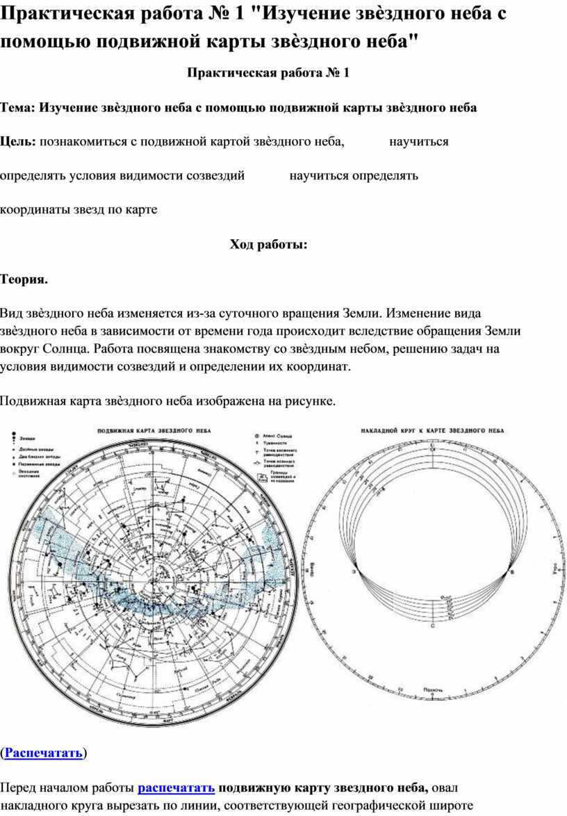
Practical work No. 1 “Studying the starry sky with the help of a mobile star map”.
Practical work No. 1
Topic: Exploring the celestial heavens using a mobile star map. Goal: Familiarizing oneself with the dynamic star map, learning how to identify the visibility conditions of constellations, and mastering the process of determining star coordinates on the map.
The appearance of the celestial heavens undergoes changes due to the Earth’s daily rotation. The alteration in the view of the starry sky throughout the year is a result of the Earth’s orbit around the Sun. This project aims to introduce individuals to the wonders of the night sky, solve problems regarding the visibility conditions of constellations, and master the skill of determining their coordinates.
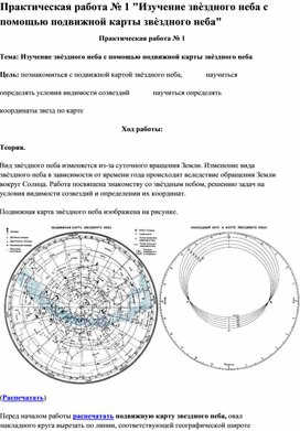
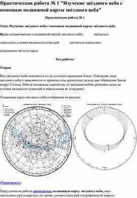
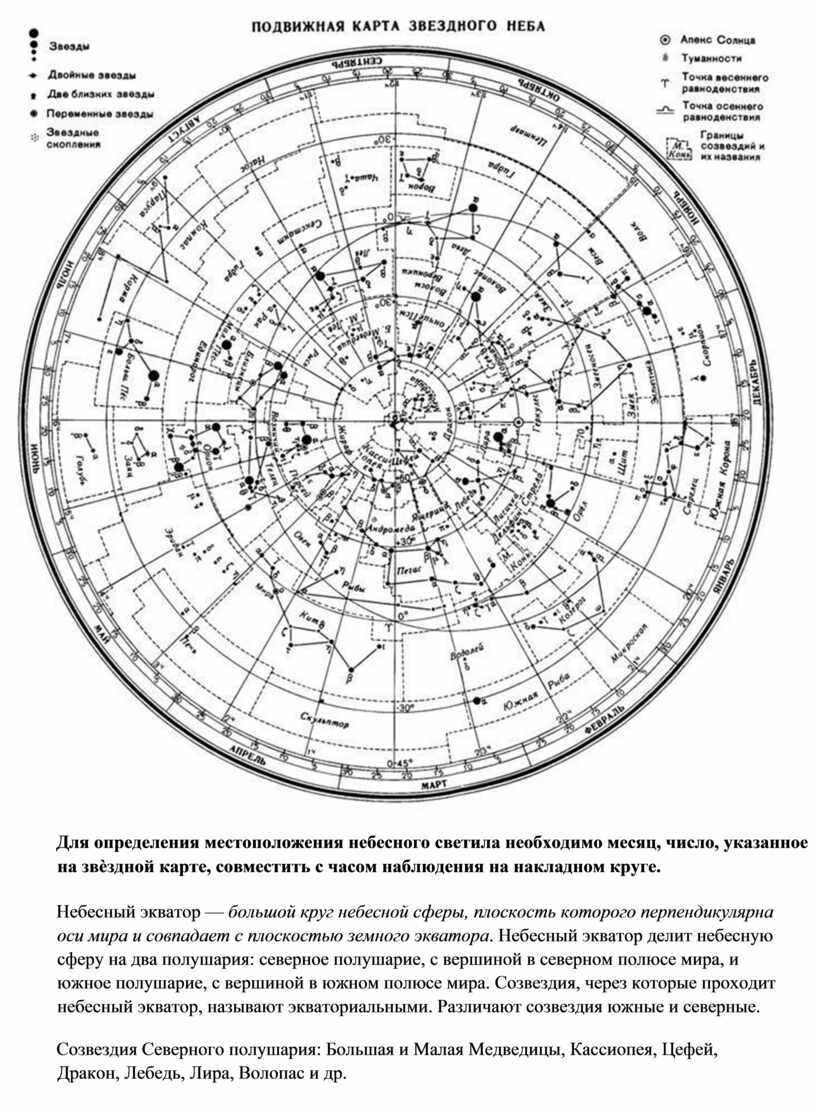
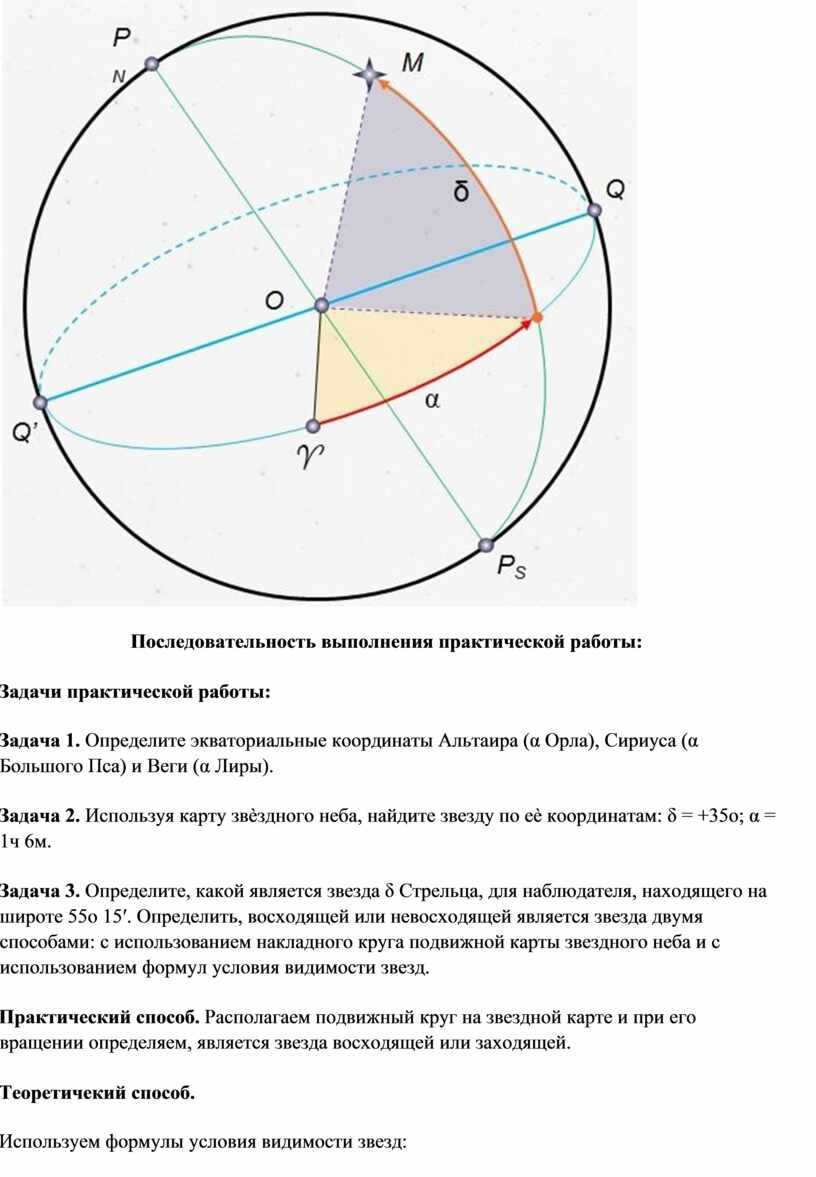
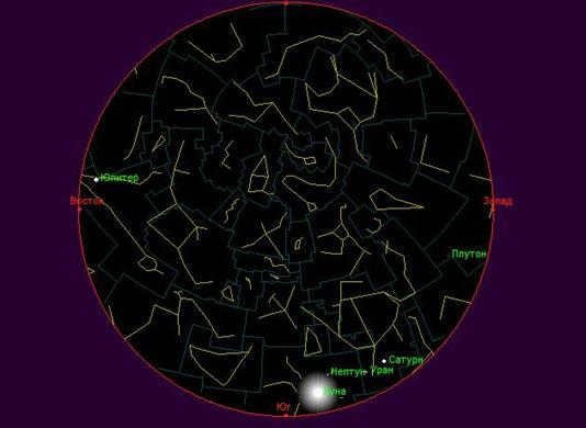
The image below showcases a mobile star map that can be used for this purpose.
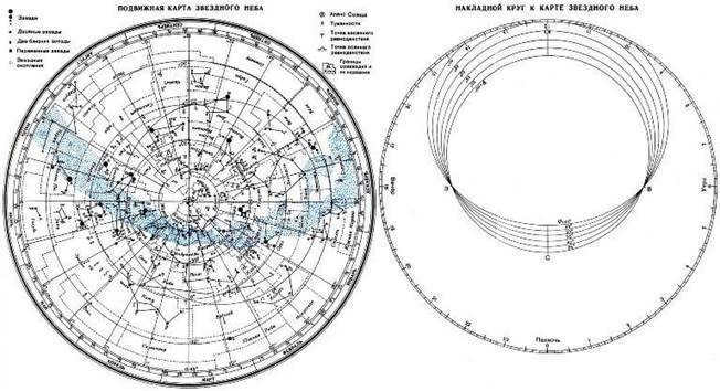
Before commencing the task, it is recommended to print and cut out the movable starry sky map, and then proceed to cut out the circular shape along the line that corresponds to the geographic latitude of the observation location. This cut line will serve as the representation of the horizon line. The star map and the circular shape can then be affixed onto a piece of cardboard. Next, a thread can be stretched from the south to the north of the circular shape to indicate the direction of the celestial meridian.
– Stars are denoted by black dots, with their sizes indicating their brightness;
– Nebulae are represented by dashed lines;
– The North Pole of the world is positioned at the center of the map;
– The position of declination circles can be seen on the star map, with lines originating from the North Pole of the world indicating their location. On the star map, the angular distance between the two nearest declination circles is equal to 1 hour;
– Celestial parallels are marked on the star chart at intervals of 30 degrees. These parallels can be used to calculate the declination (δ) of celestial bodies;
– The points where the ecliptic intersects with the equator, with right ascension values of 0 and 12 hours, are known as the points of the vernal and western equinoxes;
– The star chart includes months and numbers along the edge, and hours on the overlaid circle;
– The zenith is located near the center of the cutout, at the point where the thread representing the celestial meridian intersects with the celestial parallel. The declination of this parallel is equal to the geographic latitude of the observation location.
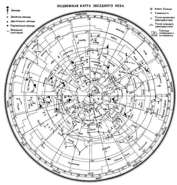
In order to determine the position of the celestial luminary, one must combine the month and the number indicated on the star chart with the observation hour on the overlapping circle.
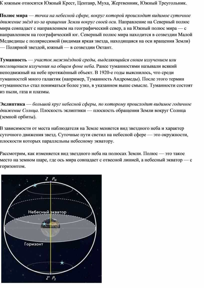
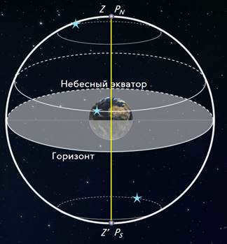
The celestial equator – is a large circle on the celestial sphere, with its plane perpendicular to the axis of the Earth and coinciding with the plane of the Earth’s equator. The celestial equator divides the celestial sphere into two hemispheres: the northern hemisphere, which has its apex at the north pole of the Earth, and the southern hemisphere, which has its apex at the south pole of the Earth. The constellations that the celestial equator passes through are known as equatorial constellations. There are southern and northern constellations.
The constellations found in the southern hemisphere include the Southern Cross, Centaurus, the Fly, the Sacrifice, and the Southern Triangle.
The celestial pole is a specific point on the celestial sphere where the visible movement of stars occurs as a result of the Earth’s rotation on its axis. The North Pole of the world aligns with the geographical north, while the South Pole of the world aligns with the geographical south. The North Pole of the world can be found in the constellation Ursa Minor with the star Polaris, which is visible due to its location on the Earth’s rotational axis. The South Pole of the world is located in the constellation Octans.
Nebula is a distinctive region of space that emits or absorbs radiation in contrast to the overall background of the sky. In the past, nebulae were classified as any large, stationary object in the sky. However, in the 1920s, it was discovered that many nebulae are actually galaxies (such as the Andromeda Nebula). As a result, the term “nebula” began to be used more specifically to refer to objects that fit the above description. Nebulae are made up of dust, gas, and plasma.
Ecliptic refers to the circular path on the celestial sphere along which the Sun appears to move throughout the year. The ecliptic plane corresponds to the plane of Earth’s orbit around the Sun.
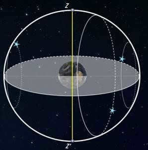
Depending on the location of the observer on Earth, the appearance of the night sky and the pattern of the stars’ daily motion vary. The stars’ paths on the celestial sphere are circular, with their planes aligning parallel to the celestial equator.
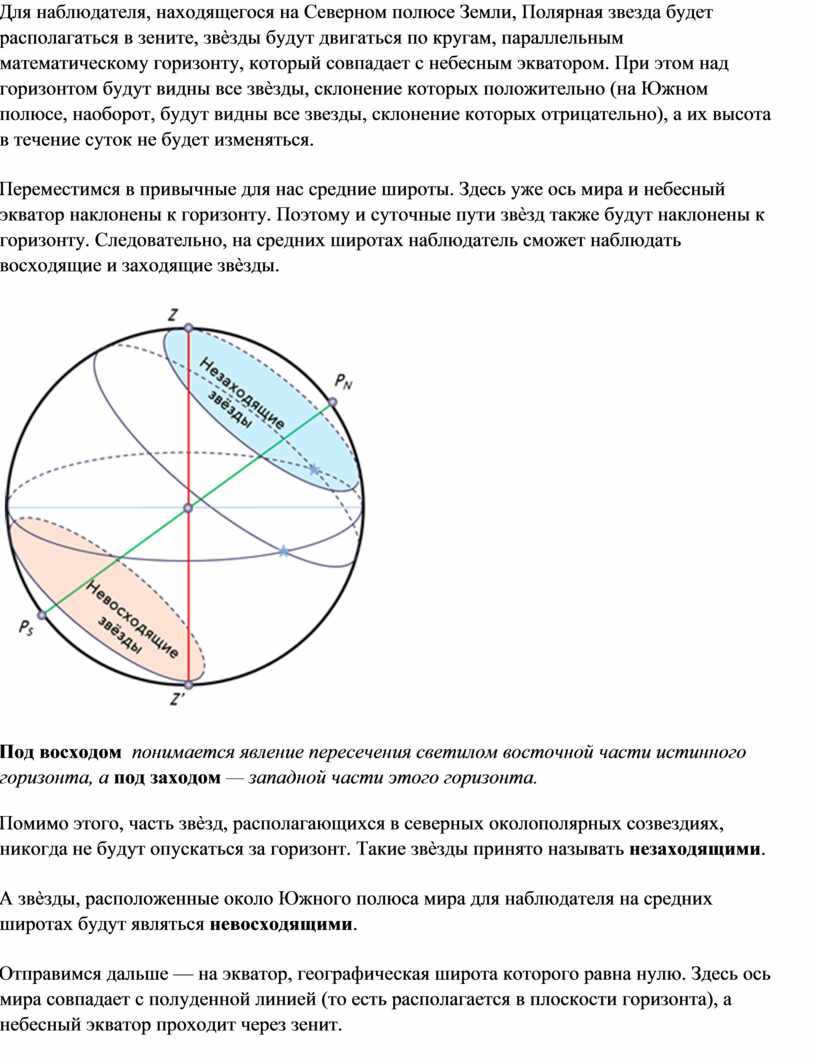
Now, let’s examine how the night sky appears at the Earth’s poles. At the poles, the axis of the Earth aligns with the plumb line, and the horizon aligns with the celestial equator.
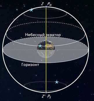
When an observer is situated at the North Pole of the Earth, Polaris can be found directly overhead, while the stars will appear to move in circular paths parallel to the mathematical horizon, which aligns with the celestial equator. This means that all stars with a positive declination will be visible above the horizon (conversely, at the South Pole, all stars with a negative declination will be visible), and their altitude will remain constant throughout the day.
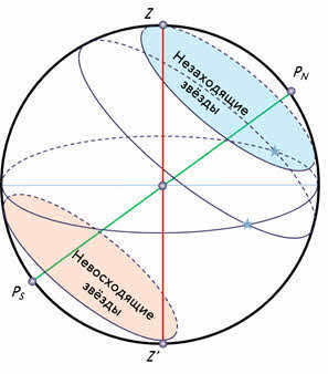
Now let’s consider the more familiar middle latitudes. In these regions, the Earth’s axis and the celestial equator are inclined in relation to the horizon. As a result, the daily paths of the stars will also be inclined with respect to the horizon. This means that observers at middle latitudes will be able to witness the rising and setting of stars.
The term “rising” refers to the occurrence of a celestial body crossing the eastern part of the true horizon, while “setting” refers to its crossing of the western part of the true horizon.
In addition, there are certain stars in the northern circumpolar constellations that never descend below the horizon. These stars are commonly known as “non-sunsetting.”
Conversely, stars located near the South Pole for an observer at mid-latitudes are considered “non-rising stars.”
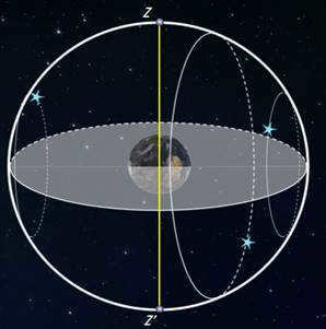
Now, let’s explore the equator, which has a geographic latitude of zero. Here, the Earth’s axis aligns with the noon line (or the plane of the horizon), and the celestial equator passes directly overhead at the zenith.
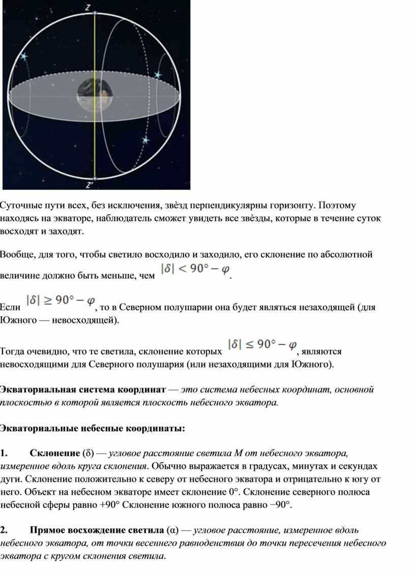
Daily paths of all stars, without exception, run perpendicular to the horizon. Therefore, when located on the equator, an observer will have the opportunity to observe all the stars that rise and set during the day.
In general, for a star to rise and set, its absolute declination must be less than [insert value].
If [insert value], then in the Northern Hemisphere it will be non-ascending (for the Southern Hemisphere – non-descending).
It is evident that those celestial bodies with a declination of [insert value] are non-superior for the Northern Hemisphere (or non-setting for the Southern Hemisphere).
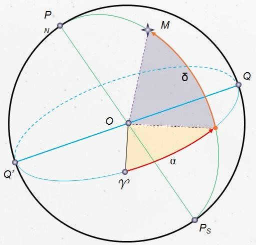
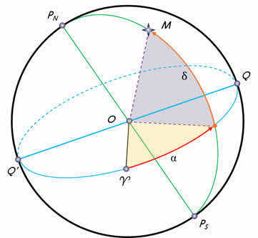
The equatorial coordinate system – is a system of celestial coordinates where the primary plane is the plane of the celestial equator.
Equatorial celestial coordinates:
1. Declination (δ) – represents the angular separation of luminary M from the celestial equator, measured along the declination circle. It is commonly expressed in degrees, minutes, and seconds of arc. Declination is positive when north of the celestial equator and negative when south of it. An object located on the celestial equator has a declination of 0°. The declination of the north pole of the celestial sphere is +90° while the declination of the south pole is -90°.
2. The right ascension of a luminary (α) – represents the angular separation, measured along the celestial equator, from the point of the vernal equinox to the point where the celestial equator intersects with the luminary’s declination circle..
Sequence of practical work:
Objectives of the practical work:
Task 1. Find the equatorial coordinates of Altair (α Eagle), Sirius (α Big Dog) and Vega (α Lyra).
Problem 2. Use the starry sky map to locate the star with the coordinates: δ = +35o; α = 1h 6m.
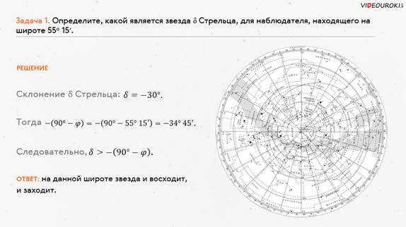
Problem 3. Determine the star δ of Sagittarius for an observer at latitude 55o 15ʹ. Determine if the star is ascending or non-ascending in two ways: using the overlapping circle on the rotating starry sky map and using the visibility of stars formulas.
Practical method. Place the movable circle on the star map and rotate it to determine if the star is ascending or descending.
We employ the formulas regarding the visibility conditions of stars:
If , the star will rise and set.
If , the star will not descend in the Northern Hemisphere.
If , the star will not ascend in the Northern Hemisphere.
Problem 4. Determine the mobile map of the starry sky for the specified day and time of observation and identify the constellations situated in the southern region of the sky from the horizon to the celestial pole; in the east – from the horizon to the celestial pole.
Task 5. Discover the constellations located between the points of the west and north on October 10th at 21:00. Verify the accuracy of the definition by visually observing the starry sky.
Task 6. Identify constellations on the star map that have nebulae marked within them, and verify if they are visible to the naked eye during the specific day and time of the laboratory work.
Task 7. Determine whether the constellations Virgo, Cancer, and Libra will be visible at midnight on September 15. Also, identify the constellation that will be near the northern horizon at the same time.
Task 8. Determine which of the following constellations – Little Bear, the Little Knight, the Magpie, the Ascendant, and Orion – will not be visible at sunset for your latitude.
Task 9. Locate and identify any five constellations from the list: the Big Bear, Little Bear, Cassiopeia, Andromeda, Pegasus, Swan, Lyra, Hercules, and Northern Crown. Then, determine the approximate celestial coordinates (declination and right ascension) of the stars within these constellations.
Problem 10. Identify the constellations that will be in close proximity to the horizon in the North, South, West, and East on May 5th at midnight.
Control questions to reinforce the theoretical material for the practical lesson:
1. What is the night sky? (The night sky refers to the collection of celestial bodies that are visible from Earth during the nighttime. It consists of thousands of twinkling dots on the firmament. Ancient astronomers divided the night sky into twelve sectors and assigned them names and symbols, which are still recognized today.)
2. What are constellations? (Constellations are regions that divide the celestial sphere to facilitate navigation in the night sky. In ancient times, constellations were created by connecting bright stars to form recognizable figures.)
3. How many constellations exist today? (There are currently 88 constellations. Each constellation varies in terms of the area it occupies on the celestial sphere and the number of stars it contains.)
4. Enumerate the major constellations or the ones you are familiar with. (There are both major and minor constellations. The major ones include the Big Dipper, Hercules, Pegasus,
Aquarius, Capricorn, and Andromeda. The minor constellations include the Southern Cross, Chameleon, Flying Fish, Little Dog, and Bird of Paradise. Of course, this is just a small selection, with the most famous ones mentioned.)
5. What is a sky map? ( It is a representation of the starry sky or a portion of it on a two-dimensional plane. Astronomers have divided the sky map into two parts: the southern and northern hemispheres, similar to those of the Earth.)
6. What does the term “celestial equator” refer to? (The celestial equator is a great circle on the celestial sphere that is perpendicular to the axis of the Earth and coincides with the plane of the Earth’s equator.)
Upon completion of the practical work, it is required for the student to submit a report.
The report should encompass responses to all the specified points of the work order and also provide answers to the control questions.
1. Vorontsov-Vel’yaminov B. A., Straut E. K. “Astronomy. 11th grade”. Textbook with electronic appendix – M.: Drofa, 2017
Practical Exercise № 1 “Exploring the Celestial Sky using a Dynamic Star Map”.
Extend a string from the southern to the northern part of the overlapping circle, indicating the orientation of the celestial meridian

In order to determine the position of the celestial body, one must combine the month, the number indicated on the star chart, and the observation hour on the celestial sphere.
The constellations in the southern hemisphere include the Southern Cross.
For someone situated at
All stars, without any exception, have their daily trajectories at right angles to the horizon.
The order of practical activities:
When a star rises and sets, it can be classified as an ascending and a setting star

Enumerate the prominent constellations or the ones you are familiar with.


The content on this page has been sourced from publicly available information or shared by users in compliance with the site’s terms and conditions. If you notice any violations, please report them.

It is common knowledge that Polaris, situated near the North Pole of the globe, maintains a nearly constant height above the horizon at a specific latitude. However, as an observer starts to move from the northern region towards the southern region where the geographic latitude is lower, Polaris will gradually descend towards the horizon. It can be assumed that there is a correlation between the elevation of the world pole and the geographic latitude of the observation location. Throughout this tutorial, we will explore this relationship. Furthermore, we will investigate the concept of a luminary’s culmination, as well as the terms “rising” and “setting” of luminaries. Lastly, we will acquire the knowledge of how to determine the geographic latitude of a specific area through astronomical observations.
Currently, it is not possible to view or share the video lesson with students
In order to access this and other video lessons included in the package, you will need to add it to your personal account.
Unlock amazing possibilities


Lesson plan “Observing the movement of stars at different latitudes”
In previous lessons, we have been introduced to star charts. These charts represent a projection of the celestial sphere onto a plane and are plotted using a specific coordinate system.
Typically, star charts are based on the celestial equator, which is the main circle of the celestial sphere. The coordinates used in this system are declination and right ascension.
Furthermore, we have discovered that during the daily rotation of the starry sky, Polaris, which is positioned near the North Pole of the Earth, maintains a relatively consistent altitude above the horizon at this latitude. However, if an observer were to travel from the North to the South, where the geographic latitude is lower, Polaris would gradually descend towards the horizon.
From this observation, it is reasonable to assume that there exists a correlation between the elevation of the Earth’s pole and the geographical latitude of the observation location. To investigate this correlation, let’s examine a section of the celestial sphere and the globe projected onto a celestial meridian plane.
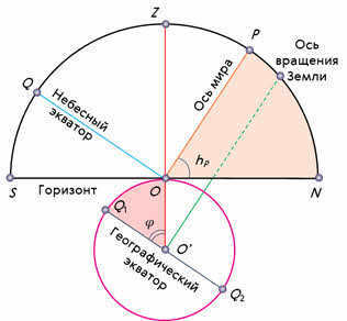
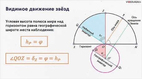
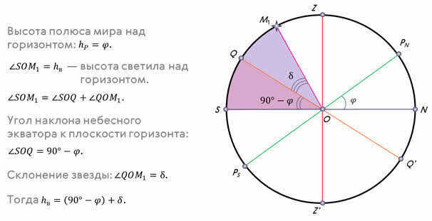
The point O represents the observer’s location. Let OR be the part of the world axis parallel to the Earth’s axis of rotation, OQ be the projection of the part of the celestial equator parallel to the Earth’s equator, and OZ be the plumb line. At point O, the observer will see the pole of the world at an altitude that is numerically equal to the angle NOP.
The angle formed by the plumb line and the geographic equator at the center of the Earth corresponds to the geographic latitude of the place of observation.
Since the radius of the Earth at the observer’s location is perpendicular to the plane of the true horizon, and the world axis is perpendicular to the plane of the geographic equator, these two angles are equal to each other as angles with mutually perpendicular sides.
Therefore, it follows that the angular elevation of a global pole above the horizon is equivalent to the geographic latitude of the observer’s location.

To put it differently, by measuring the height of the celestial pole above the horizon, we can easily determine the geographical latitude of the observation location.
Take note of the angle QOZ. From the diagram, it is evident that this angle represents the zenith’s declination, which is equivalent to the geographical latitude of the observation site and, therefore, the height of the celestial pole above the horizon.

The equation we have derived describes the relationship between the geographic latitude of the observer’s location and the corresponding horizontal and equatorial coordinates of a star.
As we discussed in our previous lesson, the stars’ daily paths on the celestial sphere are circular and parallel to the celestial equator. The nature of their daily motion and the appearance of the night sky vary depending on the observer’s location.
Understanding what happens at the poles of the Earth is easiest when considering the alignment of the world axis, the plumb line, the celestial equator, and the horizon. At the North Pole, for example, Polaris is located directly overhead in the zenith, and the stars appear to move in circles that are parallel to the mathematical horizon, which coincides with the celestial equator. As a result, all stars with positive declination are visible above the horizon (at the South Pole, it is the opposite, and all stars with negative declination are visible), and their height remains constant throughout the day.
Let us shift our attention to the middle latitudes that we are accustomed to. In this region, the axis of the Earth and the celestial equator are already inclined towards the horizon. As a result, the trajectories of stars on a daily basis will also be inclined towards the horizon. This means that observers at middle latitudes will have the opportunity to witness the rising and setting of stars.
Rising is when a celestial body moves from the eastern part of the true horizon to the western part, while setting is the opposite.
Furthermore, certain stars in the northern circumpolar constellations never go below the horizon, and these stars are commonly known as non-setting stars.
Similarly, stars near the South Pole for an observer at mid-latitudes would be referred to as non-descending.
Let’s continue our journey to the equator, where the geographical latitude is zero. At this location, the world axis aligns with the noon line, which is situated in the plane of the horizon. Additionally, the celestial equator passes through the zenith. As a result, the daily paths of all stars, without exception, are perpendicular to the horizon. This means that if you find yourself on the equator, you will have the unique opportunity to observe all the stars that rise and set during the day.
Generally, in order for a celestial body to rise and set, its declination must have a value less than .
If , then in the Northern Hemisphere it will not rise (in the Southern Hemisphere it will not set).
Therefore, it is clear that celestial bodies with a declination of are not visible at sunrise in the Northern Hemisphere (or not visible at sunset in the Southern Hemisphere).
For example, let’s determine the position of the star Delta Sagittarius for an observer located at latitude 55 o 15′ based on sunrise and sunset conditions.
During the course of a day, every star passes through the celestial meridian twice. This occurrence is commonly known in astronomy as the luminous culmination.
It is customary to differentiate between the upper and lower culmination. When a star is at its upper culmination, it is at its highest point above the horizon, closest to the zenith. The lower culmination takes place twelve hours after the upper culmination.
Now, let’s derive a formula that allows us to calculate the altitude of a star during its upper and lower culminations. To accomplish this, we will utilize the celestial sphere and some of its key lines.
Using the same logic, we can derive an equation that calculates the altitude of the celestial object when it reaches its highest point north of the zenith:

By comparing the two equations, it is not hard to discover a universal formula for the altitude of the celestial body at the time of its highest point:

It is important to keep in mind that the symbol “plus” before the brackets is used when the celestial body reaches its highest point to the south of the observer’s position (meaning its declination is lower than the latitude of the observation site), and “minus” is used when it reaches its highest point to the north.
We present to you the formula for determining the altitude of the celestial body at the time of its lowest point.
Take note that, by measuring the declination and altitude of the celestial body at the moments of highest point, it is possible to easily determine the latitude of the observer’s location.
To reinforce the material, let’s solve this problem.

Fig. 2.1. Orion Constellation (ancient star map)
| constellations – divisions of the celestial sphere that group stars together to facilitate navigation. |
Fig. 2.2. The stars in the constellation Orion are situated at varying distances from the Earth, creating the illusion that they radiate from the surface of a sphere
Imaginary circles can be delineated on both the celestial and terrestrial spheres in order to determine the celestial coordinates of the celestial bodies (Fig. 2.3, a).
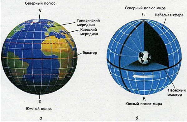
Fig. 2.3 The key points and lines of the coordinate system:
a – terrestrial (geographic), b – celestial
There are two specific points on the Earth’s globe – the geographic poles, where the Earth’s axis of rotation intersects the planet’s surface (N, S – North and South poles, respectively). The plane of the Earth’s equator, which divides our planet into the northern and southern hemispheres, passes through the center of the Earth perpendicular to its axis of rotation. Meridians on Earth pass through the geographic poles and observation points. The prime (zero) meridian passes near the former location of the Greenwich Observatory.
celestial pole – The point where the Earth’s axis of rotation intersects the celestial sphere.
The celestial equator is formed by the intersection of the Earth’s equator plane and the celestial sphere.
If we extend the Earth’s axis of rotation into space, we encounter two points of intersection on the celestial sphere known as the world poles (Fig. 2.3, b): the North Pole (currently located at Polaris) and the South Pole (in the Octanthus constellation). The Earth’s equatorial plane intersects with the celestial sphere, creating the celestial equator. This divides the sky into the Northern and Southern hemispheres. However, there is a key distinction between the poles and the equator on Earth and the world poles and celestial equator. The geographical poles exist as actual points on the Earth’s surface where the axis of rotation intersects with the planet’s surface. They can be reached by flying or traveling just like the equator. The world poles, on the other hand, do not exist as physical points in cosmic space. Therefore, the radius of the celestial sphere is uncertain, and we can only designate the direction in which they are observed.
When navigating in our daily lives, we rely on familiar landmarks such as houses, roads, and rivers to guide us in the right direction. However, when we find ourselves in an unfamiliar area, these familiar landmarks vanish, leaving us disoriented and prone to getting lost. In such situations, the celestial luminaries can serve as dependable reference points, as they consistently shine upon us both at home and in foreign lands.
Astronomers commonly use the terms “plumb line” and “horizon” to aid in orientation on the Earth’s surface. The plumb line’s direction is determined by the gravitational force exerted by the Earth at the observer’s location. This can be determined using a simple plumb line, which is suspended from a string. Let’s consider an observer situated at point O on the Earth’s surface, with a geographic latitude of cp (as shown in Figure 2.4). The downward direction of the plumb line, OOx, is known as the nadir, while the opposite direction, OZ, is referred to as the zenith. The horizon, on the other hand, is defined as a plane that is perpendicular to the plumb line.
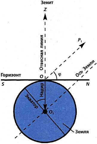
Fig. 2.4. The mathematical horizon is positioned at a right angle to the plumb line
The celestial sphere intersects with the plane of the horizon to form a circular line known as the horizon. This circle has the observer at its center. The horizon is divided into four cardinal points: N – north, S – south, E – east, W – west. These points serve as navigational aids, helping people determine their direction while traveling (Fig. 2.5).
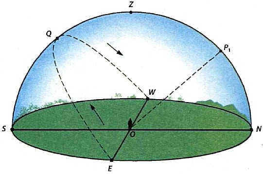
Figure 2.5. During the nighttime, it is possible to utilize Polaris P1 as a reliable point of reference, as it is aligned with the Earth’s axis of rotation. When observing Polaris, the direction facing north is in front, south is behind, east is to the right, and west is to the left. Point Q represents the culmination of the Sun
Because of the Earth’s rotation around its axis and its movement in space, it appears to us on the surface that the celestial bodies move across the horizon. We observe the Sun rising in the east and reaching its highest point at noon, which astronomers refer to as the upper culmination. This occurs when the Sun crosses the meridian plane and is directly above the southern point.
To find out the exact moment when the Sun reaches its highest point in the sky, you can use a stick placed vertically to the horizon (Fig. 2.6). To determine this culmination, it is important to observe the length of the shadow: when the Sun is directly south, the shadow will point north and will be at its shortest length. During March and September, the Sun rises close to the east and sets near the west. In the summer, the Sun rises in the northeast and sets in the northwest. In the winter, the Sun rises in the southeast and sets in the southwest. At certain latitudes, there are stars that never set, so we can observe not only the upper culmination but also the lower culmination when the celestial body is at its lowest point above the horizon.
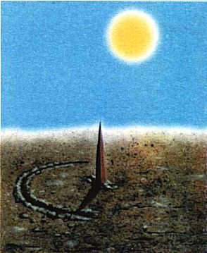
Figure 2.6. The wand’s shadow points north at noon
Equatorial system for celestial coordinates and star maps
In this coordinate system, the main planes are the celestial equator and the declination circle. To determine the equatorial celestial coordinates of the star S, the declination circle is drawn through the poles P1 and P2 which intersects the celestial equator at point M (Fig. 2.7).
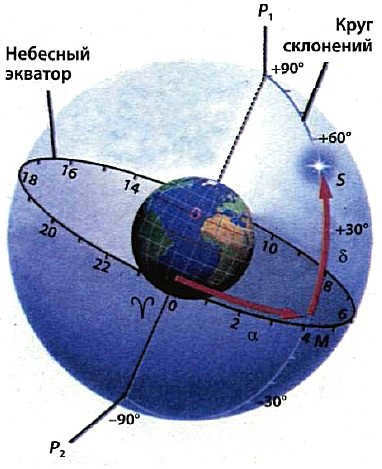
Fig. 2.7. Equatorial system of celestial coordinates
The initial coordinate is known as right ascension and is measured in hours along the celestial equator from the point of the vernal equinox counterclockwise when observed from the North Pole. The second coordinate, known as declination, is determined by the arc of the celestial declination circle from the equator to a specific celestial body and is measured in degrees. North of the equator, declination is positive, while south of the equator it is negative. The limits of the equatorial coordinate definition are as follows:

A rectangular star chart is a specific representation of the celestial sphere projected onto a plane, where the equatorial coordinates α, δ are indicated (Figure 2.8). These coordinates remain constant regardless of the observer’s location on Earth and undergo minimal changes throughout the year. As a result, the star map can be utilized in any country. However, over thousands of years, the equatorial coordinates of stars may undergo significant alterations due to the shifting position of the celestial equator and the poles of the world, as well as the rotation of stars around the center of the Galaxy (see § 15).
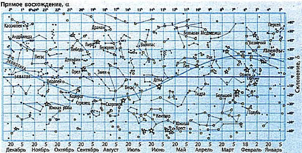
Fig. 2.8. A representation of the equatorial starry sky can be seen in this circular map. The bottom of the map is marked with the dates when these constellations reach their highest point in the evening. To observe them, look towards the southern part of the sky after sunset.
Displayed in the center of the map, near Polaris, is the North Pole of the world. A radial line extends from the North Pole, representing the circle of declination in projection on the map’s plane. The celestial equator is depicted as a highlighted circle on the map, with concentric circles every 30°.
The value δ on the map represents a radial line segment extending from the equator to a specific star. The declination of stars at the equator is 0 degrees, while at the North Pole it is +90 degrees. The direct ascension on the map is the arc of the equator starting from the vernal equinox point and extending to the radial line passing through the given star. To facilitate navigation, it is marked on the equator at regular intervals of one hour (1 h, 2 h, 3 h, etc.).
As the Earth rotates around its axis, the position of the horizon in space shifts, causing all celestial bodies to also change their position relative to the horizon. The moments when these celestial bodies cross the plane of the horizon are known as their rising or setting. To determine these moments, a movable map of the night sky, called a planisphere, can be used. This map features a special circle overlay with the horizon line and meridian. It is designed to be used in any country in the northern hemisphere, specifically at the geographical latitude of Ukraine (+50° ±5°).
For those who are curious
Star charts do not display planets because they have a different orbit around the Sun and their equatorial coordinates change over time. To accurately locate the planets in relation to the stars, it is necessary to refer to an astronomical calendar (see § 3, 4).
Key Points
The celestial sphere, an imaginary construct, aids in determining the precise position of celestial bodies within a specific coordinate system. Stellar maps utilize the equatorial coordinate system, which relies on right ascension and declination to pinpoint the location of stars. Additionally, celestial luminaries can assist in establishing the directions of the horizon, particularly in unfamiliar territory.
Unique Tests
- Where is the north pole of the world located?
A. In the Arctic.
B. In the Antarctic.
C. In the constellation Orion.
D. In the constellation of the Big Dipper.
E. Near Polaris. - What is the term for the moment when the luminary has the greatest height above the horizon?
A. Direct ascent.
B. Upper culmination.
C. Lower culmination.
D. Upper culmination.
E. Lower culmination. - Can the constellation Big Dipper be simultaneously observed in Canada and Ukraine?
A. It is not possible.
B. It can only be seen in summer.
C. It can only be seen in winter.
D. It can be seen at any time.
E. It is possible only in spring. - Is it possible to see Polaris simultaneously in Australia and Ukraine?
- What is the term for the points where the celestial sphere intersects with the Earth’s axis of rotation extended into space?
A. Zenith.
Б. Nadir.
В. The pole of the world.
Г. The geographic pole.
Д. Horizon. - When does the Sun reach its highest point in the sky?
- On which days of the year does the Sun rise in the east and set in the west?
- In Australia, can Polaris be used to determine the direction north?
- How can one determine the direction south when at the North Pole?
- Locate a prominent star on a star chart and record the times it rises, sets, and culminates using an overlaid circle.
- Using a movable star chart, identify the constellations that never set for an observer in Ukraine.
- What is the term for the points where the celestial sphere intersects with the Earth’s axis of rotation extended into space?
Key Concepts and Terms:
Zenith, culmination, celestial equator, celestial meridian, celestial sphere, direct ascension, poles of the world, declination, vernal equinox point.
Lesson Goals. By the end of this lesson, students will be able to understand the meaning of constellations, the factors that cause their shapes to change, how a constellation’s position shifts throughout the day, and how the North direction can be determined using Polaris. Additionally, students will learn how stars are designated using Greek alphabet letters, and how to determine the best time to observe constellations and stars. They will also be able to identify the type of starry sky based on the date, location, and time of observation.
Key Concepts. Constellations. Stars. Planets. Rotation of the starry sky. Apparent magnitude of stars. Equatorial coordinate system.
Display material. A map of the starry sky that can be moved.
Individual student activity. Completing search tasks using an electronic planetarium.
Lesson’s perspective. Developing students’ logical thinking skills and scientific approach to studying the world. Constellations are not related to characters in myths and legends; in reality, constellations consist of stars (and other objects that students will learn about later) located on the boundaries of a specific part of the sky, with stars in constellations being far apart from each other and their “neighborhood” only appearing to be close. The starry sky is a visible representation of stars that are not connected to each other by gravitational forces.
Implementation of new information technologies: The use of the interactive whiteboard and interactive modules from the series “Open Collection: Astronomy, Grades 10-11” (Windows, Linux).
Lesson stages:
Methods and techniques:
II. Knowledge activation. Introduction of new material.
III. Knowledge consolidation. Observable changes in the position of constellations throughout the day.
Students’ responses to questions using the interactive “Planetarium” model and a movable map of the night sky.
IV. Reflection. Development of skills and abilities.
Engagement with tests to assess learning and initiate initial reinforcement of the material.
Teacher’s feedback on homework assignments.
Introduction: Organizational Moment
Astronomy is the oldest field of study. In the early days of human civilization, when basic forms of production were just beginning, nomadic tribes already needed to navigate in order to find their way back to their previous campsites. As agriculture developed, there arose a need to track time in order to regulate farming activities. The one constant presence throughout history, always above us, is the awe-inspiring night sky. Ancient civilizations gradually learned to navigate and keep track of time using the stars. “It’s possible that over three millennia ago, a Chaldean shepherd had a better understanding of the night sky than most of us do now, even though he believed the Earth was flat and the stars were lanterns.” “We may not often consult a geographical atlas, but we can easily locate numerous countries on a map. The stars are visible on clear nights, ready for study, and they pique our curiosity. However, not all of us can identify and name a dozen constellations.”
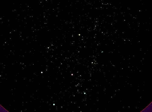
Fig. Starry sky in the region of the Orion constellation (winter sky).
Basic understanding of the concept of “constellation”:
- A constellation is a specific area of the sky with well-defined boundaries;
- There are a total of 88 constellations, as officially recognized by the International Astronomical Union (IAU);
- All stars within constellations are designated using letters from the Greek alphabet, with the brightest stars often having their own names. If the supply of Greek letters is exhausted, stars are then designated using letters from the Latin alphabet. Finally, if necessary, stars are numbered;
- There are exceptions to this naming convention, as not all of the brightest stars are given names starting with the first letters of the alphabet;
- Stars within constellations are located at varying distances from the observer;
- The Big Dipper is comprised of seven main stars;
- One of the reasons for the changing contours of constellations is the movement of the Earth;
- The position of a constellation can change throughout the day due to the rotation of the Earth.
1) Spotting Polaris in the night sky;
2) Determining the north direction based on the position of Polaris;
3) Finding the optimal time for observing constellations and stars;
4) Identifying the times for the rising and setting of constellations.
How can one navigate using the stars, considering the vast number of them visible in the sky? It may be overwhelming to distinguish among these numerous bright points. However, it is important to note that only around 3000 stars are visible to the naked eye, and out of those, approximately 30 are the brightest and most captivating. Additionally, not all of these stars are visible in our hemisphere.
Furthermore, the human brain possesses an innate tendency to search for order and meaning amidst apparent disorder. It is believed that even early humans, at the dawn of civilization, began to navigate through the vast expanse of stars by identifying and mentally connecting patterns formed by groups of stars, which aids in this endeavor. These star patterns, or configurations of stars, are commonly referred to as constellations. Interestingly, in most Germanic languages (excluding English), the term “constellation” directly translates to “star pattern”. For instance, the ancients depicted the hunter Orion by connecting the stars in this region of the night sky (the teacher uses the cursor to trace the area of the starry sky where the constellation Orion is situated).
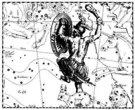
Orion’s position in the star map created by Hevelius.
Stars in the night sky have specific positions and coordinates. How do we determine where one constellation ends and another begins? The boundaries and names of constellations were established in 1922 during the first congress of the International Astronomical Union (IAU). The entire celestial sphere was divided into 88 constellations. Today, a constellation refers to a specific region of the night sky rather than a distinct group of bright stars, allowing for the assignment of all stars, both bright and faint, to constellations.
Utilize an electronic planetarium to display the current limits of constellations in the celestial sky.
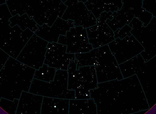
Contemplate one of the most luminous assemblages of stars in the north celestial hemisphere, which has been distinguished by nearly every nation as a constellation, the Ursa Major asterism..
A part of the celestial sphere that includes the constellation Ursa Major.
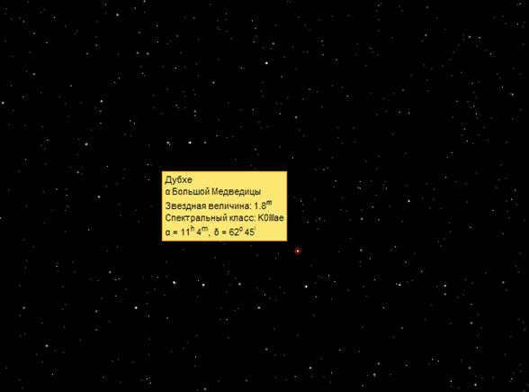
In ancient eras, individual names were assigned to the brightest stars in each constellation. As a result, the seven stars of Ursa Major were given the names: Dubhe, Merak, Fekda, Megretz, Aliot, Mitsar, and Benetnash.
Students can use the Planetarium to draw the shapes of stars and label them. They can also click on the stars to discover their names.
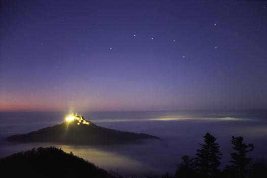
The Hohenzollern castle in the Alps. Courtesy of Astronet.
Get ready this illustration beforehand and display it on the interactive whiteboard.
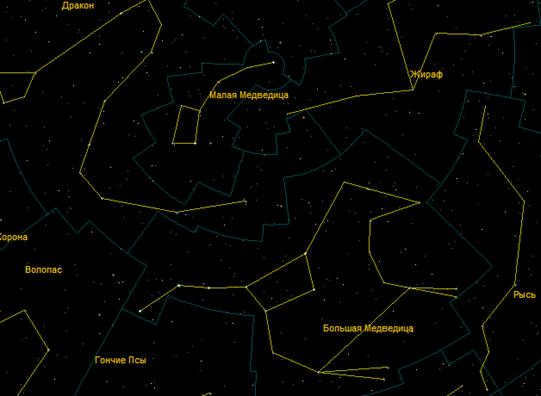
Illustrate a simple method for determining the north direction based on the position of the Big Bucket asterism:
- Draw an imaginary line connecting the two outermost stars, which are the furthest from the handle (Dubhe and Merak);
- Extend this line and locate a relatively bright star. This star is Polaris and it is easily identifiable as there are no other prominent stars in this area.
Students are introduced to a dynamic celestial map. On the outer rim of the map, you can see sections labeled with the names of the months and a scale displaying numerical dates. Now observe the overlaid circle. Surrounding the circle’s perimeter are the hours. Position the circle on the map so that the “23 h” marker on the circle aligns with the date September 2 on the map. The portion of the sky visible through the “window” represents what can be observed above the horizon on September 2 at 23 h, at the latitude of Moscow. The horizon line for Moscow’s latitude is indicated by the boundary of the “window” on the superimposed circle. The cardinal directions are marked here as well. Objects in the east are ascending while those in the west are descending.
The arrangement of the stars in the celestial sphere, which rotates as a cohesive unit, is determined using coordinates.
III. Generalization of knowledge. Observable changes in the position of constellations throughout the day.
Students will respond using the interactive “Planetarium” model.
1. Choose the same time on the interactive Planetarium model and compare the view of the starry sky above the horizon in winter and summer.
2. How many degrees does the starry sky rotate in one hour?
3. Which star rises in the east at 6:00 a.m. on July 20? (Canis Minor)
Mentally draw a line on a moving map connecting the north and south points – this line represents the noon line. The celestial bodies that are on the noon line at the moment they reach their highest position above the horizon during the day are said to be culminating.
- Find out when the climax of b Orion occurs. By rotating the star chart with the overlaid circle, you can simulate the daily rotation of the sky.
- The electronic planetarium displays the overhead circle as a screen.
- Is it possible to see the complete constellation of the Big Dipper at all times? At what time does it reach its highest point above the horizon?
- Which planets are currently visible at 23:00?
- Which planets will be visible at 23:00 in six months?
IV. Development of Skills and Abilities. Reflection
To ensure that the entire class can see the task, it is recommended to project the test tasks on the interactive whiteboard. Difficult questions should be explained while addressing the whole class. Pupils can answer using the interactive “Planetarium” model.
- What is a constellation?
- a certain arrangement of stars that are conventionally grouped together;
- a specific area of the sky with defined boundaries;
- a three-dimensional shape that extends infinitely, with the observer’s eye at the top;
- a collection of bright stars.
a. within a 24-hour period;
b. over the course of one year;
c. spanning thousands of years;
d. within an average human lifespan.
a. The swan;
b. The Magpie;
c. Lion;
d. Gemini.
a. Dragon;
b. Gemini;
c. The Little Bear;
d. Giraffe;
e. Cassiopeia;
f. Cepheus;
g. Lizard.
a. Southern Crown;
b. Centaurus;
c. Sails;
d. Eridanus.
Answers to the quiz

The collaborative initiative known as the "Gutenberg Smokehouse" educational project, in partnership with AST publishing house, has recently launched a series of popular science books called the "Gutenberg Library". These books aim to introduce the general public to the fundamentals of various scientific disciplines. One of the inaugural titles in this series is Irina Pozdnyakova's book titled "Amateur Astronomy", which not only delves into the history of significant astronomical discoveries but also provides guidance on how to independently explore the wonders of the night sky. N + 1 presents an introduction to a chapter within the section titled "General Recommendations for Novice Observers".
Getting acquainted with the celestial sky
The impact of excessive lighting
To begin with, just like the ancient Greeks, Romans, and Arabs, individuals are blessed with a magnificent celestial dome that stretches above their heads. However, due to the excessive presence of street lighting, the ability to witness the beauty of the stars has become increasingly challenging. In urban areas, only the most radiant stars and planets, as well as the Sun and the Moon, remain visible to the naked eye.
As a result of the detrimental effects of light pollution, a staggering 60% of Europeans and nearly 80% of North Americans are deprived of the opportunity to witness the luminous band of the Milky Way – the celestial projection of our Galaxy’s disk.
During the 1994 Los Angeles earthquake, a power outage occurred, causing widespread panic and reports to the police about the presence of a mysterious “giant silvery cloud” over the city. Eventually, it was discovered that the cloud was actually the Milky Way, which had become obscured by the bright lights of the metropolis.
Fortunately, there are still regions in Russia where both the Milky Way and 6th magnitude stars can be observed. To experience this breathtaking sight, it is recommended to venture at least 20-30 km away from any urban areas.
The concept of the celestial sphere and star charts
To our eyes, the sky appears like an immense dome, or more accurately, a sphere. In ancient times, it was believed that this was an actual transparent solid sphere (or multiple spheres), and contemporary astronomers still utilize the notion of the “celestial sphere,” referring to an imaginary sphere upon which all visible celestial bodies are projected.
Fascinatingly, the phrase “the seventh sky” is linked to the notions of astronomers who employed the geocentric model of the universe.
Star maps are essential tools for amateur astronomers to make observations. There are various types of star maps available. Some feature lines that connect the brighter stars in constellations, making it easier for beginners to navigate the night sky. Other maps do not include these lines but instead show the boundaries of constellations, as well as celestial coordinates. These maps may also display dimmer stars, nebulae, galaxies, and star clusters that are not visible to the naked eye. They are specifically designed to be used with telescopes or other optical instruments.
In order to locate a specific star or object on the map and then find it in the sky to point a telescope towards it, it is necessary to have an understanding of the celestial coordinate system.
In the horizontal coordinate system, the luminary’s location is measured in relation to the horizon plane. The primary reference points in this system include the cardinal directions (north, south, east, and west), the zenith (directly above the observer), and the nadir (directly below the observer). The luminary’s position in relation to the cardinal directions is referred to as azimuth, while its position in relation to the horizon is known as altitude. Both azimuth and altitude are measured in degrees of angular measurement.
However, due to the apparent rotation of the celestial sphere, the altitude and azimuth of the celestial bodies are constantly changing, making this system unsuitable for mapping purposes. Instead, the equatorial coordinate system is employed. In this system, the celestial equator serves as the fundamental plane, representing the projection of the Earth’s equator onto the celestial sphere. The celestial poles, which are the projections of the Earth’s poles onto the celestial sphere, play a crucial role. In the vicinity of the northern celestial pole, one can find Polaris, a bright celestial body with a magnitude of 2 stars. On the other hand, there are no similarly bright celestial bodies near the southern celestial pole. However, the direction to the southern celestial pole can be determined by the constellation known as the Southern Cross, which is located much farther away from it compared to the distance between Polaris and the North Pole.
Moreover, there is the ecliptic on the celestial sphere, which is a large circle where the Sun’s annual movement through the zodiacal constellations occurs. The ecliptic can be seen as a projection of the Earth’s orbit on the celestial sphere.
The equivalent of terrestrial latitude is known as declination, which is measured from the celestial equator to the poles of the world. The equivalent of Earth’s longitude is measured from the vernal equinox, one of the two points where the ecliptic intersects the celestial equator.
The ever-changing appearance of the starry sky influenced by location, time of day, and year
As we are aware, the stars move across the sky in circles around the Earth’s poles due to its rotation on its axis. When observing the rotation from the Earth’s poles, the pole of the world will be directly above us, at the zenith, and the stars will move parallel to the horizon, never extending beyond it. This means that only one hemisphere of the celestial sphere will be visible to the observer, while the stars from the other hemisphere will never rise above the horizon.
At the equator of the Earth, the situation appears very distinct. The celestial equator aligns with the zenith, while the northern and southern poles of the globe rest on the horizon line. The stars ascend and descend, traversing the sky perpendicular to the horizon. As the celestial sphere revolves around the equator over the course of the year, we are able to observe all the stars from both celestial hemispheres above the horizon.
At latitudes between the poles and the equator, the view is a blend of both. The pole of the world can be seen at a height that matches the geographic latitude of the location (for example, in Moscow it is 56°). The celestial equator is tilted in relation to the horizon and becomes higher the closer the area is to the geographic equator. As a result, we can observe more stars from the opposite hemisphere. Some stars rise and set, while others in the near-polar region, near the pole of the world, never set. The boundary where stars no longer set diminishes as we approach the equator and as the pole of the world descends towards the horizon.
Aside from its rotation, the Earth also revolves around the Sun, which can be observed against the backdrop of the starry night sky. Naturally, we are unable to see the stars near the Sun during daylight hours, but in a darkened sky, the stars closest to it are the first to disappear in the early evening and the last to emerge before dawn.
However, as the Earth moves each day, the Sun gradually shifts its position in the sky, causing the stars to appear in slightly different locations. Over the course of a day, the Sun moves about 1 degree along the ecliptic. It takes approximately 4 minutes for the Earth to traverse this angle. Consequently, the stars rise and set approximately 4 minutes earlier every 24 hours, with evening stars drawing closer to the Sun and morning stars moving farther away from it. (In astronomical terms, the sidereal day is 4 minutes shorter than the solar day).
As a consequence, the rising and setting times of stars shift by one hour every two weeks, and by two hours over the course of a month. During the same time of day, certain constellations will move to the west, while others will appear in the east. Consequently, after 12 months and the completion of Earth’s orbit around the Sun, the configuration of the starry sky completes its yearly cycle of transformation.
How to Begin Exploring the Wonders of the Night Sky
For those new to stargazing, identifying constellations can seem like a daunting task. Not only are there countless stars to navigate, but many star maps also distort the shapes of constellations due to the nature of map projections. However, don’t lose hope. With time and practice, you’ll eventually be able to spot the constellations you’ve been searching for, and you’ll wonder how you ever missed them before.
When starting your journey into the world of constellations, it’s best to follow a certain algorithm. Begin with the brightest, most prominent constellations that are well-known and easily recognizable. These constellations can serve as landmarks and reference points for locating others.
For people living in the Northern Hemisphere, the constellation Big Dipper near the pole can serve as a starting point. In middle latitudes, it does not go below the horizon, and in the evening it is relatively easy to locate its “bucket” of seven stars: in autumn – not far above the northern horizon, in winter – higher up in the northeastern part of the sky, in spring – high up (almost directly above for Moscow), and in summer – in the northwest.
The Big Dipper is a great reference point for finding other stars and constellations. One well-known method is to use it to locate Polaris by extending the line formed by the outer edge of the “bucket.” However, as depicted in the diagram, this remarkable group of stars can be used to find many other constellations as well.
Starting from the group of stars known as the Big Dipper, you can locate Polaris and the constellation called the Little Dipper. Nearby, you can also learn to identify the constellations Draco, Cassiopeia, Cepheus, and Perseus. Additionally, by following the direction indicated by the Big Dipper, you can find the more distant constellations Leo, Vulpecula, and Boötes.
Next, you can search for the constellations that are visible in the evening sky in the southern part during specific seasons of the year. In the autumn, the constellations Pegasus and Andromeda are prominent and together they resemble a larger version of the Big Dipper. Once you have located them, you can then look for the constellations Aries and Perseus, followed by the fainter ones such as Pisces, Triangulum, and Cetus….
The primary constellation in the winter sky is undoubtedly Orion, which features its impressive “bow” adorned with the brilliant stars Betelgeuse and Rigel, as well as its distinctive “belt” composed of three stars. By following this “belt” upwards and downwards, one can locate other prominent stars such as Aldebaran in Taurus and Sirius in the constellation of Canis Major. Additionally, the remaining winter constellations can be discovered, including both notable ones that possess first magnitude and brighter stars like Gemini, Ascendant, and Canis Minor, as well as fainter ones like Monoceros and Lepus.
In the spring sky, the main constellation is Leo, featuring the luminous star Regulus. Once Leo is identified, it becomes easier to spot other bright celestial bodies such as Arcturus in Boötes and Spica shining in Virgo. Subsequently, one can embark on the search for the other, less conspicuous constellations, including Cancer, Corvus, Crater, Hydra, Leo Minor, Sextans, and Coma Berenices.
During the summer and autumn seasons, there are three prominent stars that can be observed in the southern part of the sky: Vega, Deneb, and Altair. These stars represent the main constellations of Lyra, Cygnus, and Aquila respectively. However, when viewed together, they form the Autumn-Summer Triangle. This celestial formation serves as a great starting point for exploring the summer sky, allowing observers to then seek out other constellations such as the Northern Crown, Hercules, Serpens, Scorpius, Sagittarius, Capricornus, Aquarius, Vulpecula, Delphinus, Sagitta, and Scutum.
If you’re interested in exploring the starry sky, you can easily find online star maps on the Internet. These maps provide a visual representation of the night sky, allowing you to see the current view as well as the view at any given date and time in the past or future. Feel free to check out one such map right here.
If you want to explore the sky more thoroughly and with ease, you have the option to install a planetarium program on your computer, phone, or tablet. A notable choice among amateur astronomers is the free program Stellarium, which offers a realistic simulation of numerous celestial phenomena. Additionally, there are numerous other virtual planetariums available, each offering a diverse range of features and functions, ensuring that everyone can find one that suits their individual requirements.
Astronomical Observations: Exploring the Stars with Optical Instruments
Gone are the days of ancient astronomers relying on angle measuring instruments. Today, amateur astronomers have a wide range of optical devices at their disposal to explore the wonders of the night sky.
If you’re new to astronomy and eager to start observing, binoculars are a great choice for your first optical instrument. They are lightweight, compact, and offer a wide field of view, making them perfect for general sky exploration. With binoculars, you can marvel at the Milky Way, observe bright nebulae and star clusters, and even get a closer look at the Moon’s surface. They are also handy for observing comets as they streak across the night sky.
When purchasing binoculars, the primary factors to consider are the size of the objective lens (known as the aperture) and the level of magnification. For instance, binoculars labeled as “6×50” have an aperture of 50 mm and a magnification of 6x. While there are larger binoculars available with higher magnification, such as “20×100”, they are not suitable for handheld use due to their weight and resulting image instability (as the shaking of the hands is amplified by the high magnification). Therefore, these bulkier instruments can only be used with the support of a tripod. The optimal parameters for binoculars used for sky surveys and handheld observations are typically 7×50 or 8×56.
Of course, a truly passionate amateur astronomer is unlikely to limit themselves to just one pair of binoculars, and the next natural progression would be to invest in a telescope.
Amateur telescopes are predominantly classified into the initial two categories that emerged historically – refractors and reflectors.
Refractors are highly convenient to utilize due to their sturdy tube design and airtightness, requiring minimal adjustment and maintenance. They provide a vivid and crisp image, especially when observing planets. However, refractors also have their drawbacks. The refraction of light rays at different wavelengths in the glass causes chromatic aberration, resulting in the image becoming colored at the edges (excluding costly models known as apochromats). Additionally, telescopes with larger lens diameters tend to be more expensive compared to those of other systems.
Making a mirror is a simpler task compared to creating a lens with the same diameter, resulting in reflectors being generally more affordable than refractors. Moreover, mirrors are lighter in weight, leading to a reduction in the overall weight of the telescope. Reflectors also eliminate chromatic aberration since the rays are reflected rather than refracted. However, reflectors do come with their own set of disadvantages. The image produced by reflectors tends to have lower contrast due to the light loss during its reflection on a small secondary mirror, which also restricts some light from entering the tube. Additionally, the design of the reflector’s tube is not completely airtight, allowing dust and dirt to easily accumulate inside. Over time, the mirror coating may fade. Reflectors also experience a different type of aberration known as spherical aberration, causing objects at the edges of the field of view to appear more blurred compared to the center. Furthermore, reflectors often require alignment (optical adjustment) as part of their design.
There exist optical configurations that incorporate both lenses and mirrors. Among hobbyists, the Schmidt-Cassegrain and Maksutov-Cassegrain systems are widely recognized. These systems feature corrective lenses positioned in front of the mirror. They offer several advantages over refractors and reflectors, including a compact and portable design. However, it should be noted that they are typically more expensive than both refractors and reflectors.


