The Size of the Earth – a guide for kids: the Earth’s shape and measurements, comparing it to other celestial bodies like Jupiter, the Sun, Sirius, and stars, its radius, and notable features like Mount Everest and the Mariana Trench.
To us, the Earth may seem incredibly vast. Many children surely dream of traveling around the world, realizing that it could take a lifetime to accomplish. However, there exist even larger planets within the solar system and the universe. Let’s explore the dimensions of the Earth.
To introduce the concept to young learners, parents or educators in the classroom can begin by explaining that our planet, Earth, is the third largest planet in our solar system and the fifth largest overall (it is smaller than the gas giants Jupiter, Saturn, Uranus, and Neptune). However, if we were to compare the terrestrial planets, Earth would rank ahead of Mercury, Venus, and Mars.
Explaining Earth’s radius, diameter, and circumference to children
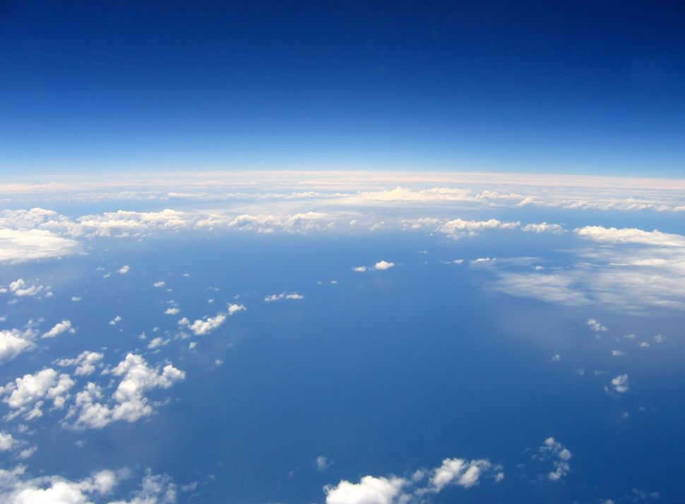
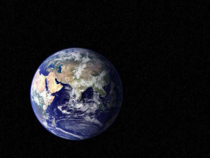
An illustration providing a visual representation of the Earth’s size

For young children, it’s important to understand that the Earth has an average radius of 6371 km. However, it’s not just the size that matters, but also the shape. The Earth is not perfectly spherical. Due to its rotation, it bulges at the equator, which has a diameter of 12,756 kilometers. To help children understand the difference, you can explain that at the poles, the diameter is 12,714 km (a difference of 42 km).
The equatorial circumference is 40,030 km, but the meridional (pole to pole) circumference is 40,008 km. This is because the Earth is flattened at the poles, giving it a shape known as an oblate spheroid.
Explanation of Earth’s density, mass, and volume for children
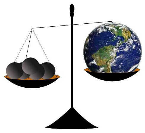
Earth has a density of 5.513 grams per cubic centimeter, which is quite impressive. This is because of its metallic core and rocky mantle. It’s important for children to understand that even though Jupiter is much larger and 318 times more massive, it has a lower density due to being filled with gases, specifically hydrogen.
- Mass – Earth has a mass of 5.9222 x 10 24 kilograms.
- Volume – Earth has a volume of 1 trillion cubic kilometers.
- Total surface area – Earth has a total surface area of 510 million square kilometers, with 71% of it being covered in water and 29% being land.
Explanation for Kids: Earth’s Highest and Lowest Points
Hey kids! It’s important to know that Mount Everest (8848 meters) is the highest point on Earth. However, if we look at it technically, there’s another object that claims the top spot. Mount Chimborazo in the Andes (Ecuador) may be 10,000 feet shorter when measured from sea level, but it actually extends 2.4 km higher into space due to its equatorial bulge.
On the other hand, the lowest point on Earth is the Mariana Trench, located in the western Pacific Ocean. It goes down to a depth of 11,034 meters below sea level.
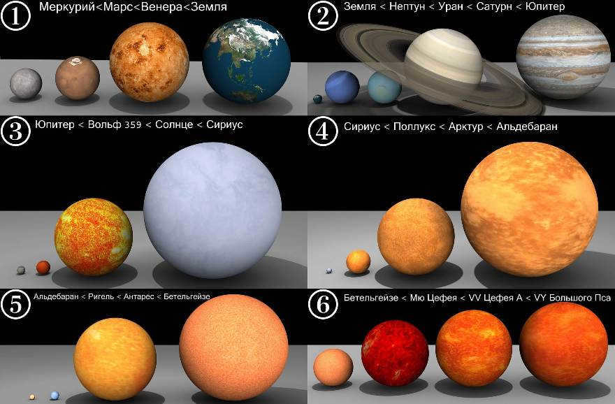
If you want to expand your knowledge about the Earth and its shape, make sure to explore the other sections where you can find more interesting facts and details. Don’t forget to utilize the 3D model of the Solar System that showcases all the planets, as well as the map of Venus, displaying its surface and orbital characteristics. Additionally, our collection of photos, pictures, and drawings, along with the availability of a real-time online telescope, will always assist you. To better comprehend the vast scale, it is helpful to refer to a chart that compares the sizes of Earth with other planets or stars.
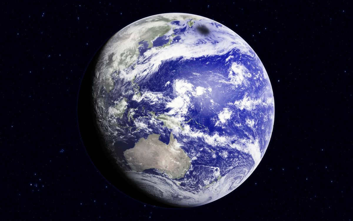
Planet Earth, the third planet from the Sun in our solar system, is known by various names such as the cradle of humanity, the Blue Planet, Gaia, and even the World. Currently, it is the only known planet in the scientific community that supports life.
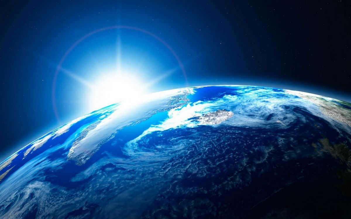
Planet Earth is the sole identified planet that is home to living organisms. Credit: sunhome.ru
Creation and development of Planet Earth
The Earth is estimated to be around 4.5 billion years old. During its early stages, it was not yet a fully formed planet and existed as a proto-Earth – a rotating cloud of gas and interstellar dust. Over time, this cloud began to condense. There is a theory suggesting that this compression was triggered by a shockwave originating from a supernova explosion in deep space. As the cloud became more compact, it also grew hotter. The interstellar dust particles gradually merged together, forming larger conglomerates. Eventually, a sphere of molten rock took shape.
Around 2.5 billion years ago, the Earth experienced conditions that allowed for the emergence of early life in the oceans. This marked the appearance of ancient plants, which played a crucial role in oxygenating the atmosphere.
The process of Earth formation, accompanied by the descent of meteorites, lasted for approximately 100 million years. Credit: 1zoom.ru
As the conditions gradually approached the modern ones, the variety of life on Earth increased. Around 500-400 million years ago, the first aquatic animals emerged, and their descendants eventually transitioned to terrestrial habitats.
Physical characteristics of the Earth
Earth is one of the terrestrial planets. Terrestrial planets are defined as planets that have a solid surface, a metallic core, and a diameter that is approximately 0.1 times the diameter of the Sun. Other planets in this group include Mercury, Venus, and Mars. However, Earth is the largest and most dense among them. It has an average diameter of 12,700 kilometers, a mass of 5.97×10^24 kg, and a density of 5.513 kg/m³. In the solar system, Earth ranks as the fifth largest planet.
| Equatorial radius | 6.38 thousand km |
| Polar radius | 6.36 thousand km |
| Equatorial circumference | 40 thousand km |
| Surface area | 510 million square kilometers |
| Land area | 148.9 million square kilometers |
| Free fall acceleration | 9.78 m/sq. s |
| Speed of rotation around its axis | 1.67 thousand kilometers per hour |
| Tilt of the rotation axis to the orbital plane | 66°34′ |
| Albedo | 0.3 |
| Temperature at the surface | -89.2…+56.7°C |
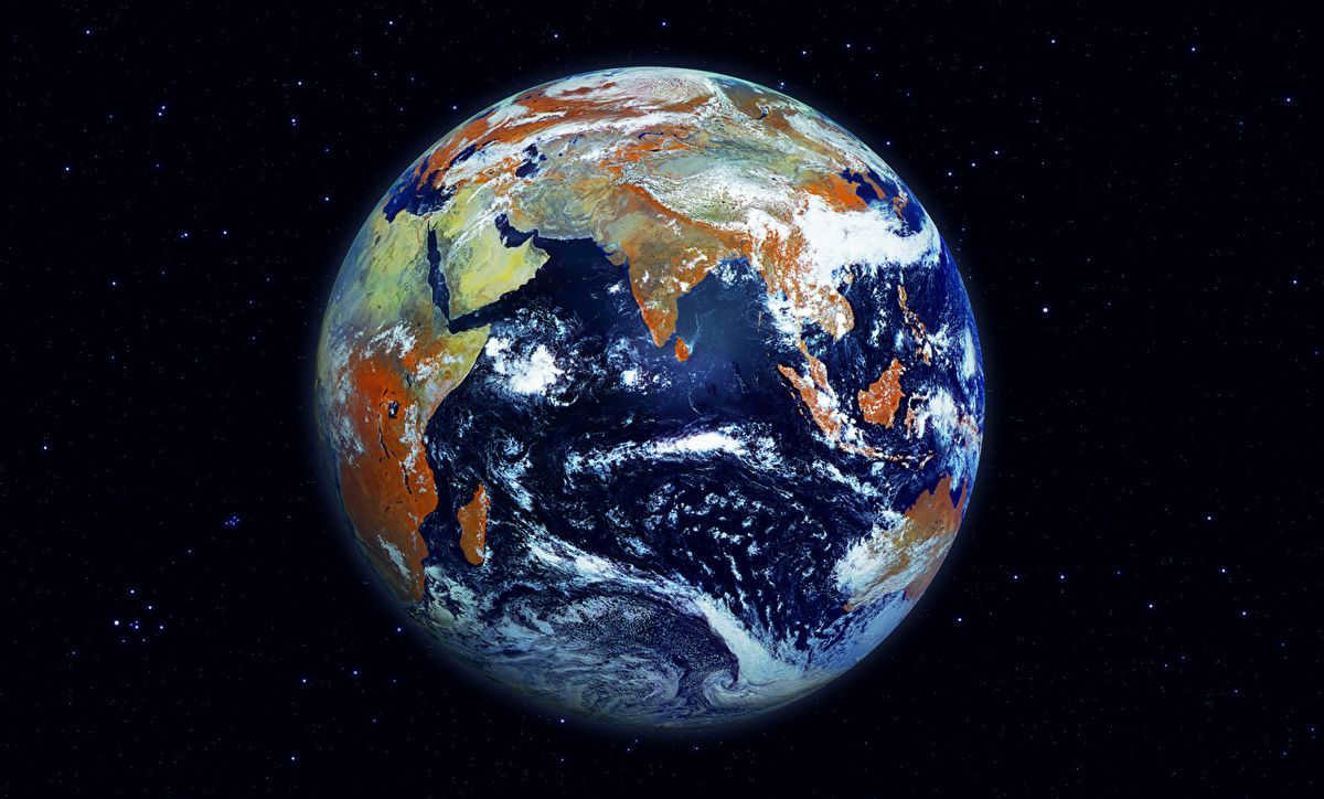
The Earth possesses a well-developed atmosphere, hydrosphere, and inner shells. Credit: nastol.com.ua
Orbit and rotation
The distance between the Earth and the Sun is approximately 150 million kilometers. The Earth follows an elliptical orbit around the Sun, moving from west to east. At the same time, it also rotates around its own axis in the same eastward direction. The length of the Earth’s orbit is about 940 million kilometers, with an average orbital velocity of 29.8 km/s.
The Earth completes one orbit around the Sun in approximately 365.24 days, while one rotation around its axis takes about 23 hours and 56 minutes. These values determine the length of a year and a day on our planet. Compared to other terrestrial planets, the Earth rotates on its axis faster, but slower than gas planets.
Moreover, alongside the Sun and all the planets within our solar system, the Earth orbits in a circular trajectory around the central region of the Milky Way, which happens to be our galaxy. The velocity at which this movement occurs is 220 km/s.
Magnetic Field
Located at the core of the Earth lies an iron-nickel core. As it rotates, it generates the magnetic field of our planet. The region encompassing the Earth, within the boundaries where the forces of the magnetic field act, is known as the magnetosphere. As a result, all living organisms on the Earth’s surface are shielded from the solar wind, which consists of a stream of charged particles emanating from the Sun. The magnetosphere redirects this stream away from the Earth’s path.
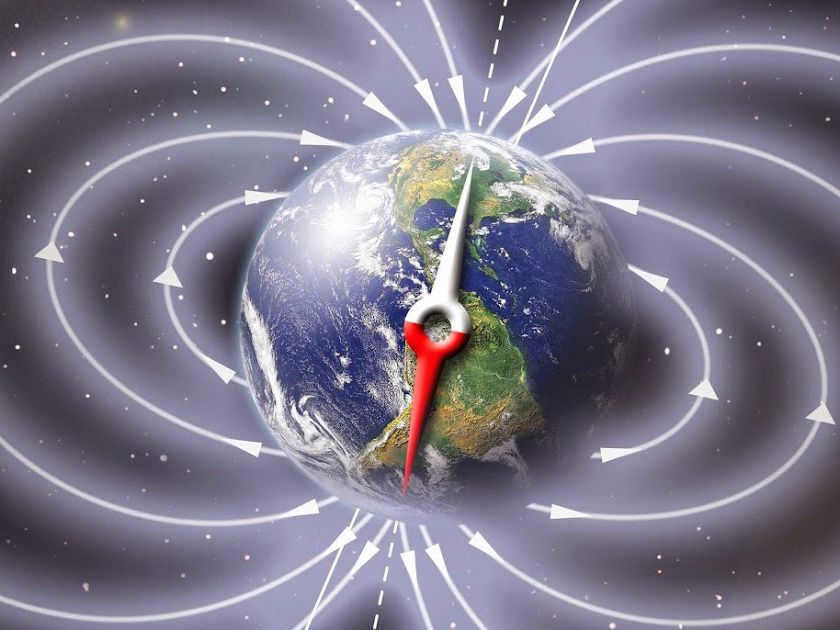
The Earth’s magnetic field possesses a pair of poles that are closely aligned with the planet’s geographic poles. These regions serve as entry points for particles that can give rise to the phenomenon known as the northern (polar) lights, or Aurora. When particles from the solar wind interact with molecules of oxygen, a vibrant display of red and yellow hues is emitted, while the presence of nitrogen molecules generates a captivating blue glow.
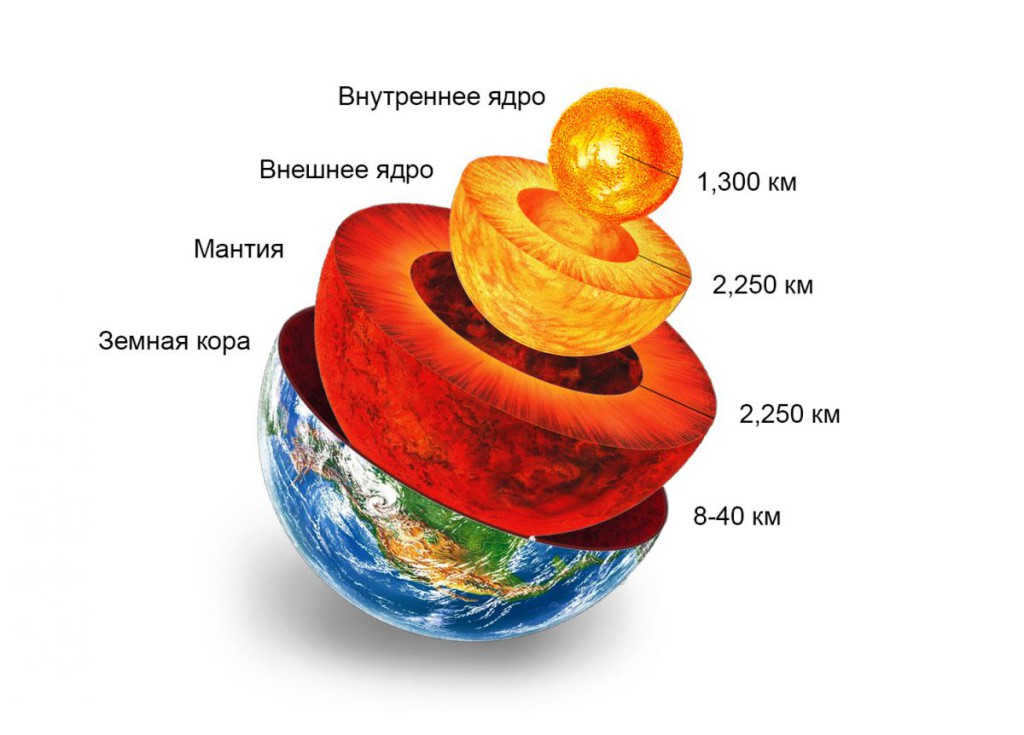
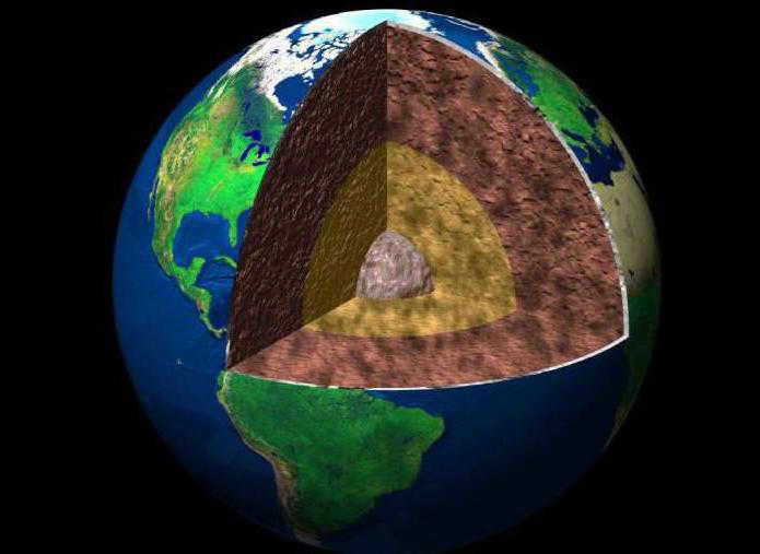
Structure of the Earth
The Earth possesses a stratified composition. As depth increases, the following sequence of layers can be observed:
- crust;
- upper mantle;
- mantle;
- liquid outer core;
- solid inner core.
The Earth’s crust is comprised of the lithosphere and asthenosphere, which correspond to the upper and lower layers, respectively. The lithosphere is composed of tectonic plates that are in contact with each other and exhibit slow relative motion. The average thickness of the lithosphere is 64 km, with the continental crust being thinner than the oceanic crust. The Earth’s largest tectonic plates are:
- Eurasian.
- Antarctic.
- African.
- North American.
- South American.
- Pacific.
- Indo-Australian.
The asthenosphere is an intermediate layer separating the lithosphere from the upper mantle, consisting of viscous, molten rock. Within this stratum, turbulent currents occur, resulting in the movement of tectonic plates. When these plates collide, slide past each other, or separate, seismic activity ensues, leading to the formation of mountains and canyons.
As one delves deeper into the Earth, the composition of the mantle undergoes a transformation, transitioning into a solid state. Comprised of silicate rocks, the mantle extends to a depth of 2,900 kilometers. It constitutes 83% of the planet’s volume and 67% of its mass.
The Earth’s core, located beneath the mantle, is the planet’s most scorching and densest region. It boasts temperatures soaring up to 4,000 degrees Celsius. The outer core has a radius of 3.4 thousand kilometers, while the inner core measures 1.2 thousand kilometers. Comprised of iron and sulfur, the core’s liquid portion is juxtaposed with a solid section made up of iron and nickel.
The formation of the Earth’s hydrosphere commenced approximately 4 billion years ago, encompassing a vast collection of water resources:
- The planet’s expansive oceans.
- The freshwater bodies found on continents.
- The frozen water reserves, including snow cover and glaciers.
- The water vapor and clouds that populate the atmosphere.
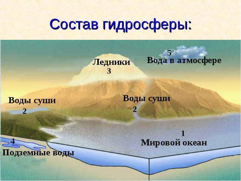
The Earth’s hydrosphere is composed of the world ocean, which is a vast body of water covering approximately 70% of the planet’s surface, while the remaining portion consists of landmasses such as continents and islands. The world’s oceans include:
- Oceans:
- The Pacific Ocean
- The Atlantic Ocean
- The Indian Ocean
- The Arctic Ocean
- The Southern Ocean (established in 2000)
- Seas
- Bays
- Straits
Continental waters encompass various bodies of water such as lakes, rivers, groundwater, and swamps. Along with ice and snow, these freshwater reserves constitute approximately 2.5% of the Earth’s hydrosphere.
Earth’s Atmosphere
The Earth’s atmosphere is the envelope of air that surrounds the planet, extending up to an altitude of 550 km. It is composed of several layers, including:
- The troposphere, which extends up to 12 km;
- The stratosphere, which spans from 12 to 50 km;
- The mesosphere, which ranges from 50 to 80 km;
- The thermosphere, which extends from 80 to 1000 km;
- The exosphere.
The characteristics of the various layers differ from one another. The lower layers of the atmosphere have the highest density, and as altitude increases, density decreases. The troposphere comprises nearly 80% of the total atmospheric mass and contains 99% of the Earth’s gaseous water. Its chemical composition includes the following gases:
- nitrogen (78%);
- oxygen (21%);
- the inert gas argon (1%);
- carbon dioxide or CO2;
- water vapor.
During the transition to the mesosphere, the temperature drop resumes and reaches -80…-100 °C. This layer is where silver clouds composed of frozen water crystals form. Despite being the coldest atmospheric layer on Earth, the majority of meteorites that fall on the planet burn up in this region.
In the thermosphere, the temperature starts to increase rapidly and reaches 727 °C at an altitude of 800 km. Beyond this point, the air becomes too thin to be heated by particle collisions.
The exosphere is primarily composed of the lightest gases, hydrogen and helium. It lacks defined boundaries and serves as a transitional region connecting the Earth’s atmosphere to the vastness of outer space. Within this realm, particles gain enough velocity to escape the gravitational pull of the Earth and venture into the void. The exosphere, along with the thermosphere, forms the ionosphere, where air particles become ionized due to the influence of the solar wind.
Climate of the Earth
The climate of our planet is shaped by the impact of solar energy that reaches the Earth and the various processes that take place in the atmosphere and hydrosphere, such as the water cycle, wind patterns, and the movement of cyclones. There are four primary climatic zones, including the polar, temperate, tropical, and equatorial regions, as well as four transitional zones known as the subarctic, subantarctic, subequatorial, and subtropical regions. Within each zone, the climate is relatively consistent and uniform.

The equatorial climate is the hottest among all climate types, with temperatures reaching up to +80 °C. On the other hand, the polar climate is the coldest. This temperature difference can be attributed to the way solar energy is distributed and absorbed by the Earth’s surface. In polar latitudes, light rays have to travel a longer path through the atmosphere, resulting in more energy loss along the way.
Aside from temperature-based classifications, there are other ways to categorize the Earth’s climatic zones. One such classification is based on the type of vegetation found in a particular region. According to this system, the following natural zones can be identified:
- Tropical forests
- Deserts
- Temperate zone
- Continental belt
- Polar type
Land topography
The topography refers to the physical features and shape of the Earth’s surface. Unlike other planets, the Earth’s crust is unique due to the scarcity of meteorite impact craters. Over time, these craters have been gradually erased by a variety of natural forces and geological processes, such as the movement of tectonic plates, erosion, and weathering.

Identify different types of terrain relief:
- mountains and mountain ranges;
- canyons and trenches;
- plains and plateaus;
- deserts;
- plateaus, and more.
All of these formations can be found on both land and underwater. The deepest point of the Earth’s relief is the “Challenger Deep” in the Mariana Trench, which reaches a depth of 11 km below sea level. The highest point is the summit of Mount Everest, which stands at 8.8 km above sea level.
Representation of the Earth’s Topography: Surface Map
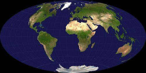
A surface map, also known as a geographic map, is a visual depiction or model that showcases the reduced form of the planet’s topography through the use of symbols. These maps can vary in scale and level of detail, and serve different purposes, whether they encompass the entirety of the Earth’s surface or focus on specific regions.
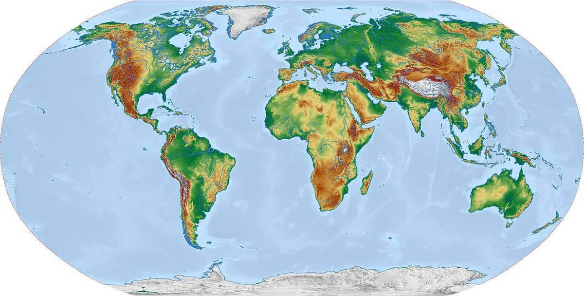
There are various types of maps, such as reference, educational, tourist, technical, navigational, thematic, and physical maps. Each of these maps includes different types of distortions that arise from the process of projecting the Earth’s curved surface onto a two-dimensional plane.
The Moon is a natural satellite of Earth and the fifth largest satellite in the Solar System. It is positioned about 384 thousand kilometers away from Earth and orbits it with a velocity of 1 km/s. As per contemporary scientific theories, the Moon came into existence approximately 4.5 billion years ago as a result of a collision between Earth and a massive celestial object. This hypothesis was proposed in 1984 and has remained the most supported one ever since.
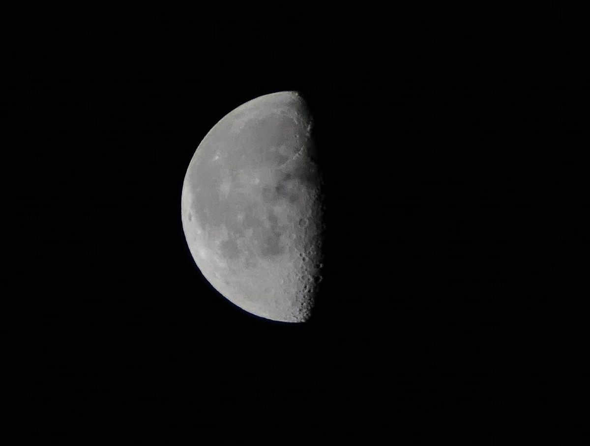
The size of the Moon is 3.5 thousand kilometers in diameter, which is only four times smaller than that of the Earth. This difference in size allows the Moon to exert a gravitational force on the Earth, resulting in the occurrence of tidal patterns. Another interesting aspect of the Moon’s gravitational interaction with the Earth is its locked position, always facing the same side towards our planet.
Unlike the Earth, the Moon lacks both an atmosphere and bodies of water. Instead, its surface is covered in regolith, a combination of dust and rock fragments resulting from meteorite impacts. The thickness of the regolith varies and can reach several tens of meters. Additionally, the Moon has weaker gravity compared to Earth, resulting in objects weighing six times less on its surface.
The Moon is the sole celestial body that has been explored by humans. The initial footprints on the lunar surface were made by Neil Armstrong in 1969. Since then, an additional 12 astronauts have journeyed to the satellite.
Existence on Earth
The first primitive life on our planet originated 3.5-4 billion years ago and consisted of intricate molecules capable of reproduction. The introduction of oxygen, the oxygenation of the seas, fluctuations in temperature, and the melting of glaciers facilitated the emergence of first unicellular organisms, followed by multicellular organisms, which embarked on the extensive evolutionary journey of life on Earth.
The following significant eras can be distinguished in the development of life on Earth:
- Paleoarchaea – the evolution of prokaryotes, bacteria, and cyanobacteria.
- Neoarchaea – the advent of oxygenic photosynthesis.
- Orosirium – the emergence of eukaryotes (single-celled organisms with nuclei).
- Stratherium – the emergence of organisms with specialized cells.
- Ectasia – the emergence of algae.
- Ediacarya – the emergence of invertebrate animals.
- Cambrian – the emergence of the first vertebrate animals.
- Ordovician – the emergence of higher plants.
- Permian – the Permian extinction event that resulted in the death of 70-90% of vertebrate species.
- Triassic – the beginning of the dinosaur era and the emergence of the first mammals.
- Cretaceous – the emergence of primates.
- Early Paleogene – the Cretaceous-Paleogene extinction event that led to the extinction of 16% of marine animal families, 18% of terrestrial vertebrate families, and non-ptycoid dinosaurs.
- The beginning of human history, around 100 thousand years ago, marked the evolution of people acquiring their modern appearance.
Scientists gain insights into the evolution of life on our planet through the examination of paleontological discoveries and the analysis of the similarities among existing species.
Exploration of other planets
The shift from mythological explanations of the world’s existence to its systematic study began in ancient times and gained momentum with the emergence of writing. The early depictions of Earth were characterized by a certain level of naivety and were later discredited as scientific knowledge advanced.
The concept of the planet being a flat disk was disproven as early as the 6th century B.C., and in the 3rd century B.C. the ancient Greek scientist Eratosthenes of Cyrenaica was able to calculate the Earth’s circumference. Around the same time, the philosopher Aristotle, also Greek, speculated about the gradual movement of the Earth’s crust and made the first attempt to determine the planet’s age. Other scientists made similar endeavors. Pliny and Shen Guo independently examined fossils and rocks for this purpose.
In the 16th century, scientific knowledge was further enriched by Copernicus’ theory of the heliocentric model of the world. At the same time, Galileo Galilei’s invention of the telescope expanded the understanding of the planet’s position in the solar system and elevated astronomy to a new scientific level.
The Explorer-6 spacecraft captured the initial photograph of the Earth in 1959, while Yuri Gagarin became the pioneer to witness our planet from space in 1961.
Subsequent studies in geology, space exploration, and observations have enabled humanity to establish an extensive understanding of the Earth as a celestial body.
The future of Earth
The fate of Earth as a planet relies on various factors:
- alterations in the Sun’s radiation;
- the rate at which the Earth’s core cools down;
- the behavior of tectonic plates;
- the influence of other planets in the solar system;
- collisions with celestial objects.
Based on one of the existing hypotheses, the planet will undergo cycles of glaciation linked to changes in its orbit and axis of rotation, which will once again lead to the extinction of numerous species.
A different hypothesis connects the future of the Earth with the anticipated rise in solar activity, which is projected to happen in 1-3 billion years. This increase in solar activity will result in the evaporation of the oceans and trigger the greenhouse effect in 4 billion years, ultimately leading to the extinction of all life on the planet. In approximately 3.5 billion years, the Earth will be engulfed by the Sun, which will have transformed into a red giant. Some scientists propose that the planet may persist, albeit with a modified orbit.
These theories all pertain to the distant future and will undoubtedly undergo further revisions as scientific understanding and knowledge of the universe continue to progress.
The Earth is a remarkable planet within the solar system, positioned approximately 149,597,890 kilometers away from the Sun. It holds the distinction of being the third planet and the only one capable of sustaining life. Its formation dates back to around 4.5-4.6 billion years ago, and it owes its unique characteristics to a multitude of factors, including its atmospheric composition and physical properties. One such property is the remarkable abundance of water, which covers approximately 70.8% of the Earth’s surface and provides a conducive environment for life to flourish.
What sets Earth apart is its status as the largest terrestrial planet among its counterparts, namely Mercury, Venus, Earth, and Mars, which are all characterized by a relatively thin layer of rock. In contrast, the gas giants, namely Jupiter, Saturn, Neptune, and Uranus, are composed primarily of gas. Taking into consideration factors such as mass, density, and diameter, Earth stands as the fifth largest planet in the entire solar system.
Topic Projects:
What are the evolving ideas about the Earth’s shape?
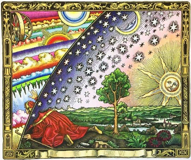
During ancient Greece in the 9th to 8th centuries B.C. (Homer’s era), the depiction of the Earth evolved to resemble a convex hemisphere, resembling a warrior’s shield. The Greeks held the belief that the land was surrounded by the ocean on all sides.

Representation of the Earth and the Universe during the time of Homer
In the 6th century B.C., Pythagoras and his followers asserted that the Earth was a sphere. It is believed that Pythagoras acquired this knowledge from Egyptian priests, who, unlike the ancient Greek philosophers, kept their discoveries hidden. However, he was unable to provide evidence for his hypothesis. The first evidence of the Earth’s spherical shape was presented by Aristotle in the 4th century B.C. Some of his observations were accurate, while others were incorrect. We will discuss this further. Aristotle demonstrated that the Earth is a sphere through the following observations:
- During lunar eclipses, regardless of the Earth’s orientation, its shadow on the Moon’s surface is always circular, indicating that only a sphere can cast a circular shadow;
- Ships, while sailing into the distance, don’t slowly fade away and remain completely visible, but almost instantly disappear beyond the line of the horizon;
- The horizon expands as it ascends;
- While traveling along the meridian, the stars visible in the sky shift: certain stars may be observable from certain regions of the Earth, while in other regions, they are perpetually out of sight.
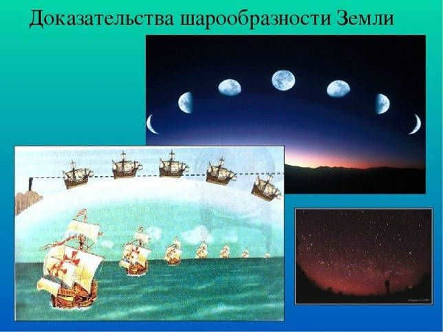
Aristotle’s proof of the Earth’s roundness
With the passage of time, the concept of the Earth’s spherical shape started to rely not only on observations but also on precise calculations. Eratosthenes, an ancient Greek scientist from the 3rd and 2nd centuries BC, was the first to determine the Earth’s size. He made calculations based on the length of a 1° arc of a meridian.
Eratosthenes observed that during the summer solstice on June 21, the Sun shines directly into the deepest wells in Siena (Aswan), indicating that it is directly overhead and the angle of the Sun’s rays is 90 °. In Alexandria, however, the Sun is at an angle of 7°12′ from the zenith, which is equivalent to 1/50th of a circle. By measuring the distance between Siena and Alexandria and multiplying it by 50, Eratosthenes was able to calculate the length of the Earth’s meridian and, consequently, its radius. The values he derived differ from modern calculations by less than 25 kilometers.
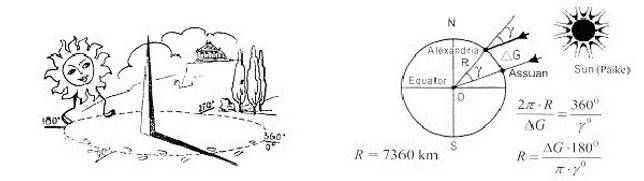
Eratosthenes of Cyrenaica’s calculations.
As a result, the ancient Greeks had mostly accurate notions about the shape and dimensions of the Earth. However, their geographical maps were flawed due to limited knowledge and insufficient exploration of land and oceans during that era.
During the Middle Ages, until the 15th century, much of the scientific knowledge from ancient civilizations was dismissed due to the dominance of the church. The destruction of the Alexandrian library led to a halt in nearly all scientific endeavors. The belief in the Earth’s sphericity was deemed heretical and vehemently rejected. The measurement of the meridian length was rediscovered by Arab and Chinese scholars, and Europeans relearned these concepts through the knowledge acquired from these societies.

In the Middle Ages, European beliefs about the shape of the Earth were quite different from our modern understanding. However, with the advent of the Renaissance in the late 15th century, there was a significant shift in knowledge acquisition across various scientific disciplines. This era of exploration and discovery, known as the Great Geographical Discoveries, expanded our understanding of the Earth’s horizons.
- In 1497, Christopher Columbus embarked on a journey to find a western route to India and instead discovered the New World (America).
- In the same year, Vasco da Gama successfully navigated a route to India by sailing around Africa.
- Between 1519 and 1522, Ferdinand Magellan and his crew accomplished the first circumnavigation of the globe.
Maps became increasingly precise and intricate, leaving no room for uncertainty regarding the planet’s shape. The Earth was officially acknowledged as a sphere and started being represented as a three-dimensional model – a globe. The inaugural globe, with a diameter of 0.5 meters, was created in 1492 by Martin Beheim, a renowned German explorer and scholar.
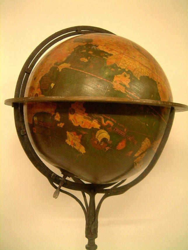
Photo of the “Earth apple” created by Martin Beheim.
This particular hypothesis was verified by the subsequent occurrence. In 1672, French astronomer J. Richet was dispatched to Cayenne (French Guiana) to conduct a study on Mars during the year of the Great Confrontation. He brought along a clock equipped with a pendulum that ticked off seconds, meaning that the duration of each swing of the pendulum was equivalent to one second. Upon arrival in Cayenne, the clock began to fall behind and the length of the pendulum had to be adjusted accordingly. Conversely, in Paris, the clock began to run ahead. I. Newton provided an explanation for the deceleration of the pendulum swing when it is transported from temperate latitudes to equatorial latitudes, attributing it to the decrease in gravitational pull caused by the increase in centrifugal force.
To determine the length of the 1° meridian arc, the French Academy of Sciences conducted two expeditions in the 19th century. One expedition went to the Arctic Circle while the other traveled to the equatorial regions. The measurements revealed that at the pole, the meridian’s length was 11.7 km, while at the equator it was 110.6 km. This confirmed Newton’s hypothesis.
A spheroid, also known as an ellipsoid of rotation, is a sphere that is flattened evenly at the poles. The Earth is a spheroid with a small amount of compression. Its equatorial radius is only 21.4 km longer than its polar radius.
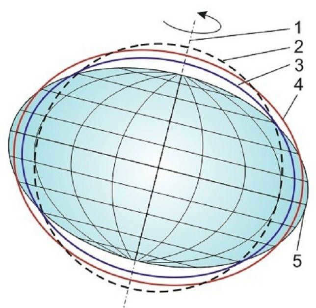
The dimensions and mass of the Earth. A rotating ellipsoid
However, the actual shape does not perfectly match a rotating ellipsoid. A rotating ellipsoid is a regular shape that occurs when a body with a uniform structure rotates. The shape of the Earth is more complex due to its non-uniform composition and uneven distribution of mass. In 1873, I. Listing introduced the term “geoid” to describe the Earth’s shape.
A geoid, also known as “earth-like,” is the accurate representation of the Earth’s geometric shape. It is a figure whose surface is always perpendicular to the direction of gravity, which is indicated by the plumb line. The geoid’s surface aligns with the level surface of the world ocean. The difference in height between the geoid and the ellipsoid can range from positive to negative 50-60 meters.
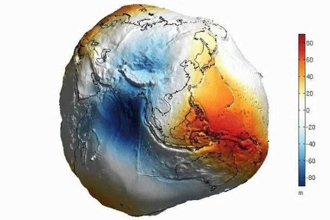
Geoid
The Shape and Sizes of the Planet “Earth”
A Flattened Spheroid
The dimensions of the Earth are quite intricate.
Our planet is not a perfect sphere, but rather a flattened spheroid, with a slight compression at the poles (known as an ellipsoid).
The distance between the South Pole and the North Pole measures approximately 12,713.505 km, while the equatorial diameter of the Earth is 12,756.274 km, making it 42.769 km wider.
Extensive measurements taken by artificial satellites have revealed that the Earth is not only compressed at the poles, but also at the equator – the largest and smallest radii at the equator differ by 210 meters.
Recent calculations indicate that the Earth’s ellipsoid is asymmetric, with the south pole being slightly closer to the equator than the north pole.
Furthermore, our planet’s surface relief is highly varied, featuring lowland plains and towering mountain ranges, as well as deep-water trenches in the ocean. The maximum difference in elevation on the Earth’s surface is approximately 20 km.
EARTH statistics:
1. The density of Earth is 5.52 g/cm3.
2. The surface temperature ranges from -96°C to +70°C.
3. The length of a stellar day on Earth is 23.56 hours.
4. Earth is located at an average distance of 1 a.u. from the Sun (149.6 million km).
5. The orbital period of Earth is 365.25 Earth days.
6. The equatorial inclination of Earth’s orbit is 23°27`.
7. The orbital eccentricity of Earth is 0.017.
8. The average orbital velocity of Earth is 29.77 km/sec.
9. The volume of all water on Earth is 0.022% of its total mass.
Examples of reporting geodetic documentation
(Executive survey)
- Vertical Program
- Tower structures (Radio and television towers)
- SHS&S (Special Auxiliary Structures and Devices)
- Current documentation
- Initial Survey
- Piles and pile fields
- Foundations, footings, anchors
- Columns, walls, slabs
- Metal structures (bridges, structures)
- Elevator shafts and stairs
- External networks
- Ramp
- Landscaping
- Timber Framing
- 3D Model (Metalwork)
Verify the file
Proof of Earth’s roundness
Presently, the following are regarded as scientific evidence supporting the notion that the Earth is round:
- Photographs and measurements taken from various distances and flight paths of the Earth by artificial satellites in space.
- Measurements of degrees on the Earth’s surface.
- Lunar eclipses.

Photographs taken from space provide evidence of the Earth’s spherical shape.
Various observations made throughout history support the notion of a spherical Earth. These include the gradual disappearance of objects behind the horizon, the increased visibility when ascending, the change in the night sky when moving along the meridian, circumnavigation, and the illumination of tall structures after sunset and before sunrise. These observations indicate the Earth’s convexity, confirming its spherical nature.
The importance of the Earth’s round shape
The size and round shape of the Earth hold significant geographical importance. The round shape of the Earth leads to a decrease in the angle at which the sun’s rays hit the surface, from the equator to the poles. This in turn leads to the formation of the main geographical pattern – the zonality of the Earth’s shell, or heat belts. These heat belts, combined with other factors such as the Earth’s distance from the Sun, its mass, and its size, result in a consistent variation in natural phenomena and processes from the equator to the poles.
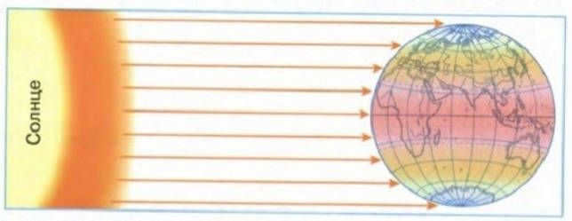
The angle at which sunlight hits the Earth’s surface
The Earth’s gravitational force, determined by its mass and size, is responsible for keeping the water and air layers intact, enabling the development of life on the planet. The distance from the Sun is another fortunate circumstance for life on Earth. If the Earth were closer to the Sun, it could have turned into a scorching desert; if it were farther away, it could have been covered in a permanent layer of ice.
The Earth’s substance spreads out in order to acquire a figure of equilibrium due to the deviation of the true shape of the Earth (geoid) from the elliptical shape. This results in the formation of sectors with a tendency to sink and rise on the Earth’s surface, along with the creation of fault zones between them.
Currently, the Earth’s rotation slowing down causes the planet to tend towards a ball shape. As a result, the Earth’s substance flows towards the poles, leading to the activation of tectonic movements.
- What is the shape of the Earth? How many answers can be given to this question?
- What evidence does modern science have of the Earth’s spherical shape?
- Tell us about the fundamental quantities that characterize the size of the Earth.
- How would the Earth’s nature be different if it had a significantly smaller or larger size but the same density?
- Physical Geography: Reference Manual for Preparatory Departments of Higher Education Institutions / G.V. Volodina, I.V. Dushina, S.G. Lyubushkina, etc.; Edited by K.V. Pashkang. – Moscow: Vysh. shk. 1991.
- Milkov F.N. General Geology: Textbook for Geography Students at Universities. Moscow: Vysh. shk. 1990.
- Savtsova T.M. General Geography: Textbook for Students of Higher Pedagogical Educational Institutions / Tatiana Mikhailovna Savtsova. Moscow: Publishing Center “Academy”, 2003.
Planet Earth is a one-of-a-kind creation in the vastness of the Universe, harboring countless mysteries. Over the centuries, humans have dedicated themselves to unraveling its secrets and enigmas: from its size to its density.
The planet is known by various names among different cultures around the world: Earth, Gaia, Terra, Mir, the blue planet. Humanity acknowledges that our planet is host to an astonishing array of diverse and remarkable life forms, yet the origins of this incredible biodiversity remain a mystery.
Earth’s dimensions
In today’s world, a variety of techniques are employed to determine coordinates in space. These methods are executed by artificial satellites equipped with special instruments.
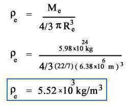
In order to ascertain the density of the Earth, it is essential to have knowledge of its mass and volume. This value is measured at 5.5 x 10 3 kg/m 3 . As depth increases, the density also increases. According to scientific calculations, the density at the planet’s core is estimated to be 1.1 x 10 4 kg/m 3 . This increase can be attributed to the presence of heavy elements and high pressure.
Scientists have deduced that the mass of our planet is equivalent to 5.972E24 kg or 6.6 sextillion tons. In terms of mass, Earth is three times more massive than Jupiter.
Density
The Earth’s density was initially discovered by I. Newton in 1736. He demonstrated that this measurement falls within the range of 5 to 6 g/cm3. Subsequent measurements have allowed for more precise data to be determined, which is referred to as the average density of the planet Earth. This value surpasses the density of the upper layers of the Earth’s crust, which can be more accurately determined based on numerous measurements of rocks that reach the surface.
Scientists have managed to calculate the density of the Earth’s surface to some degree, but it is impossible to determine what this value would be at depths greater than 16 kilometers. To ascertain these measurements, factors such as the speed of seismic waves, gravity, and various other parameters are taken into consideration.
Average density
The Earth’s average density is determined by comparing its mass to the mass of an equivalent volume of distilled water at 4 degrees Celsius. Based on this principle, scientists have determined that the average density of the Earth is 5.52 g/cm3.
Fascinating Information
There are viewpoints suggesting that Earth is the sole planet in the entire cosmos harboring intricate life forms, although this assertion has yet to be substantiated. Scientists, for some reason, hold the belief that life forms can only thrive through processes familiar to human beings on our planet, and no one acknowledges the existence of forms capable of flourishing and evolving under entirely distinct circumstances. This assertion has not been entirely disproven by anyone, thereby granting it legitimacy. While the scientific community has discovered a multitude of captivating facts about the planet:
- The average density of planet Earth exceeds that of other planets.
- While many individuals envision the Earth as a spherical object, the reality is quite different. Its shape more closely resembles two flattened semicircles with bulges at the equator, a configuration that is a result of the planet’s rotation.
- In the beginning, there existed a single landmass known as Pangaea. Over time, as the Earth’s crust shifted, the continents that we are familiar with today were formed.
- Within the planet’s protective layer, there are areas where the ozone is depleted, with the largest hole being situated over Antarctica. This significant discovery was made in 2006.
Additional Information
- When standing in one place, a person may believe they are stationary. However, in reality, they are actually moving along with the Earth. This movement is a result of the planet’s rotation around the Sun and its axis. Depending on an individual’s location, their speed in space can reach up to 1600 km/h. People living near the equator experience faster movement, while those residing in the northern and southern regions of the planet remain relatively stationary.
- The Earth orbits the Sun at a velocity of 107826 km/h.
- Scientists estimate that the Earth is approximately 4.5 billion years old.
- The Earth’s core is composed of magma.
- Water tides occur on the Earth due to the gravitational pull of the Moon, which acts as a natural satellite.
- Antarctica holds the record for being the coldest place on Earth, with temperatures dropping to -80 degrees Celsius and even lower.
- According to certain scientists, there was a time when the Earth possessed two natural satellites.
There are numerous enigmatic locations on the planet that experience peculiar occurrences. Scientists have made efforts to comprehend them: some have been successfully deciphered, while others remain shrouded in mystery. One such enigma is the motion of rocks on the Playa Plateau in the United States. Within this region, stones glide across the sandy terrain, leaving behind distinct trails. This extraordinary phenomenon is unparalleled, with no other location witnessing a similar phenomenon.
It is hypothesized that the planet once had a purple hue. This color was bestowed upon it by bacteria inhabiting every corner of the Earth. Eventually, the planet transformed into its characteristic green-blue appearance.
The distance from the Earth to the Sun measures 150 million kilometers. It takes just over eight minutes for light to travel from our star to the surface of our planet. The intensity of light increases as the distance between us and a star or planet grows. For instance, some stars emit light that takes thousands of years to reach us. Consequently, we perceive the “past” of these celestial bodies. Even the Sun is not observed in real-time but rather as it appeared eight minutes ago.
The vast expanse of space is populated by numerous comets and space debris. Fortunately, the Earth’s protective layer shields us from them, causing comets and space dust to incinerate in the upper atmosphere.
A moment of contemplation
As you are aware, the mean density of the planet corresponds to the mean density of the Earth, meaning these measures are in a 1:1 ratio. In order to determine the precise dimensions, such as mass, weight, and other measurements, various formulas are utilized.
The Earth is an extraordinary planet, harboring countless enigmas. Among these enigmas lies the question of what lies beneath the Earth’s surface, in the depths of the oceans, and what the density is beyond seventeen kilometers beneath the surface.
Researchers worldwide are intrigued by inquiries regarding the genesis of the cosmos and its actual composition. While the exploration of space fails to provide definitive answers to all queries, certain puzzles have already been solved.
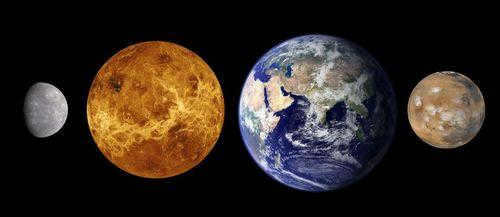
The planets in the Earth group (Mercury, Venus, Earth, and Mars)
Earth is the largest planet in the terrestrial group and has an estimated mass of 5.9722±0.0006×1024 kg. It also has the largest volume among these planets, measuring 1.08321×10¹⁸ km³.
Furthermore, our planet is the densest among the terrestrial group planets, consisting of a crust, mantle, and core. The Earth’s crust is the thinnest layer, while the mantle makes up 84% of the Earth’s volume and extends 2,900 km below the surface. The core is the component that gives Earth its density. Unlike the other planets in the Earth group, Earth has a liquid outer core surrounding a solid, dense inner core.
Earth is the largest among the Earth-group planets in terms of circumference and diameter. Its equatorial circumference measures 40,075.16 km, while it is slightly smaller between the North and South poles at 40,008 km. The diameter of Earth at the poles is 12,713.5 km, and at the equator, it measures 12,756.1 km. In comparison, the solar system’s largest planet, Jupiter, has a diameter of 142,984 km.
How much time does it take to complete a full circle around the Earth on foot?
If we know the exact distance of the Earth’s equator, we can calculate the amount of time it would take to travel around it on foot. Assuming an average walking speed of 6 kilometers per hour, we can use the formula t = S / V to estimate that it would take approximately 6700 hours, or 278 days.

The duration required to complete a continuous walk around the Earth is depicted in this image. Assuming that the hypothetical pedestrian dedicates 6 hours per day to walking, it would take approximately 1110 days, or over 3 years, to accomplish such an expedition.
Calculation of the radius and diameter
When you know the circumference, it is not difficult to calculate the radius and diameter of the sphere. The following formulas are applicable: d=l/π; r=½*π. The symbols used are as follows:
- d represents the diameter. It connects the opposite sides of the circle and passes through the center.
- l is the length of the circle. It is a line that is equidistant from the center.
- r is the radius. It is the line drawn from the center to any point on the circle.
- π is a number equal to 3.14. It is infinite, so the more digits after the decimal point, the more accurate the calculation.
It is not necessary to use both formulas. The diameter and radius are interconnected. Calculate one parameter, and then you can determine the other: the diameter is twice the radius, and vice versa.
The form of the planet Earth
Hammer-Aitov projection
The reason why Earth’s circumference and diameter are different is because it is not a perfect sphere, but rather a flattened spheroid or ellipsoid. The planet’s poles are slightly flattened, which creates a bulge at the equator, resulting in a larger circumference and diameter.
This equatorial bulge is approximately 42.72 kilometers and is primarily caused by the planet’s rotation and gravity. Gravity, in general, causes celestial bodies to contract and take on a spherical shape. This is because gravity pulls all of the mass of the object toward its center of gravity, which for Earth is its core.
As the Earth spins, the centrifugal force distorts the shape of the sphere. This force is responsible for pushing objects away from the center of gravity. When the Earth rotates, the equator experiences the strongest centrifugal force, resulting in a small bulge that increases the circumference and diameter of that region.
Although local topography does have an impact on the Earth’s shape, its influence is minimal when viewed on a global scale. The most significant variations in local topography can be observed in two prominent landmarks: Mount Everest, which stands as the highest point above sea level at an elevation of 8,848 meters, and the Mariana Trench, which represents the lowest point below sea level at a depth of approximately 10,994±40 meters. In terms of planetary dimensions, the disparity between these two extremes is relatively insignificant, measuring just 19 kilometers. However, when taking into account the equatorial bulge, the tallest peak in the world and the point farthest from the Earth’s center is actually the summit of Chimborazo volcano in Ecuador. With an elevation of 6,267 meters, it claims this distinction as the highest peak located near the equator.
The atmosphere of the Earth is primarily made up of nitrogen (78.08%), oxygen (20.95%), argon (0.93%), and carbon dioxide (0.04%), and it may also contain 0.1 to 1.5% water vapor depending on the climate.
At sea level, the average atmospheric pressure on Earth is 1 atmosphere (101.325 kPa).
About three-quarters of the mass of the atmosphere is located within the first 11 kilometers of the Earth’s surface.
The Earth’s atmosphere does not have any definite boundaries; it gradually becomes thinner and thinner as it transitions into outer space.
The Earth’s atmosphere is divided into different layers based on their density, temperature, and composition. These layers include the troposphere, stratosphere, mesosphere, thermosphere, ionosphere, and exosphere.
The equator would transform into an ocean
A shift in centrifugal force would result in a mass movement of water towards the equator from all corners of the globe. Although not an immediate process, it would be fully completed within a few years.
The implications of such a transformation would be catastrophic: the elimination of tropical regions, resorts, and vacations. Vast areas would be submerged under water, causing devastation to towns, fields, and human lives. The potential harm to marine life is unimaginable.
If the planet were to accelerate at double its current rate, millions of tons of water would surge towards the equator, leaving only the highest mountains, such as Kilimanjaro and the Andes, untouched by the deluge.
This is how the equator would appear
Earth’s path around the Sun
The average distance between the Earth and the Sun measures approximately 150 million kilometers (equivalent to 1 astronomical unit).
Perihelion, which is the point in the Earth’s orbit closest to the Sun, is located at a distance of 147.098 million kilometers (or 0.983 astronomical units).
Aphelion, the farthest point in the Earth’s orbit from the Sun, is situated at a distance of 152.098 million kilometers (or 1.017 astronomical units).
The average velocity at which the Earth travels along its orbit is 29.783 kilometers per second.
It takes the Earth approximately 365.26 days to complete one full revolution around the Sun.
A day on Earth lasts for 23 hours, 56 minutes, and 4.1 seconds.
The Earth rotates in the same direction as all the other planets in the Solar System, except for Venus and Uranus.
Earth’s 3D Model
Shortening Days and Changing Time Zones
As the Earth rotates faster, the duration of a day decreases. A mere increase in the planet’s rotation speed by 2 km/h leads to a reduction of a minute and a half in the length of a day. The more the Earth accelerates, the shorter the days become.
Imagine if we could increase the rotation speed by 160 km/h. In that case, a day would only last 22 hours instead of the usual 24! This change would be similar to daylight saving time, but on a much larger scale. We would need to adjust our clocks back by two hours every day. However, the implications go beyond timekeeping. The lack of sufficient light would have a profound impact on plants and animals, causing global changes on our planet.
Due to fluctuations in the length of the day, time zones would undergo modifications, leading to significant economic consequences for all nations. This is because many financial transactions commence at specific times throughout the day, and if the day becomes shorter, computer systems may initiate trades at different times than originally scheduled.
The acceleration of Earth’s rotation would require the replacement of all traditional clocks worldwide, along with updates to the software managing time.
The axis tilt angle of our planet, which is 23.44 degrees, is responsible for the seasonal climate on Earth.
As we move towards higher latitudes, the amount of solar energy reaching the Earth’s surface decreases.
The Earth is divided into climatic belts, which are natural zones with similar climates.
In the Köppen classification system, the type of climate in an area is determined by the types of plants that grow there. This system consists of five major climatic zones (tropical rainforest, desert, temperate, continental, and polar), each of which can be further divided into more specific subtypes.
The water cycle plays a vital role in supporting life on land.
Sea currents play a crucial role in shaping the Earth’s climate, including the thermohaline circulation, which is driven by differences in water density and transports heat energy from the equatorial regions to the polar regions.
What is the estimated time it takes to circumnavigate the planet on foot?
By calculating the length of the equatorial circumference in kilometers and knowing the estimated walking speed, we can determine the time it would take to walk around the Earth. The formula used for calculation is: t = S/V, where S represents the distance and V represents the speed.
The equatorial circumference of the Earth is approximately 40075 km. The average walking speed is 6 km/h. By substituting these values into the formula, we find that it would take approximately 6679 hours to walk around the Earth. Converting this to days, the total comes out to 278.
No one travels without taking a break. If we travel for 6 hours a day, it will take us four times longer – 1112 days. That would be equivalent to 3 years.
The calculations are based on a hypothetical scenario, as the equator only passes through land in America, Africa, and the Indonesian islands. The remaining portion of the journey would be over the oceans: the Atlantic, Indian, and Pacific.
What is the equator and why is it important?
The equator is an imaginary line that runs along the Earth’s surface, perpendicular to its axis of rotation. It is equidistant from the North and South Poles and is the longest parallel on the planet due to its spherical shape. The position of the equator varies between 22-24.5° in relation to the plane of the Earth’s orbit, which is influenced by the gravitational pull of other celestial bodies, including the Sun.
One of the unique characteristics of the equator is that it experiences equal amounts of daylight and darkness throughout the year, with no significant variations. During the equinoxes, which occur twice a year, the sun’s rays are directly overhead at this line. On other days, the angle of the sun’s rays is not significantly different. As a result, the areas near the equator receive the highest amount of ultraviolet radiation. The climate along the equator is characterized by constant warmth and humidity due to the continuous evaporation of water.
Parallels and meridians play a crucial role in determining the exact location of various objects. These geographic lines are utilized to navigate through the vast expanses of the sky, land, and water bodies. Furthermore, they also help in identifying distinct climatic zones and time zones around the world.
Interesting Earth Facts
Earth is the most extensively explored planet in the solar system and the only known inhabited planet to scientists.
Earth is the densest planet in our solar system.
Approximately 4.5 billion years ago, Earth formed from a solar nebula.
Ocean tides are primarily caused by the gravitational influence of the Moon on Earth.
Earth is home to approximately 8.7 million species, including humans.
The planet’s surface has undergone constant changes, with continents appearing, shifting, and merging into supercontinents before breaking apart into isolated land masses.
The danger of destruction comes when asteroids with a diameter of several thousand kilometers fall to the Earth, but the observed bodies are too small and only pose a threat to the biosphere.
In 1959, the Explorer 6 spacecraft captured the first photograph of the Earth from space.
Yuri Gagarin was the first person to witness the Earth from space in 1961.
By observing from outer space and from planets beyond Earth’s orbit, we can witness the Earth passing through lunar-like phases.
Overview of Earth’s Landforms
Earth’s topography is diverse and fascinating. The planet’s surface is comprised of various landforms, with approximately 70.8% covered by the world’s vast oceans.
The remaining portion of Earth’s surface is occupied by the continents, which are home to a wide range of landforms including rivers, lakes, groundwater, and ice. When combined with the world’s oceans, these landforms make up the hydrosphere.
Beneath the ocean’s surface lies a complex underwater landscape. This underwater topography features towering mountains in the form of mid-ocean ridges, as well as submarine volcanoes, oceanic troughs, submarine canyons, oceanic plateaus, and abyssal plains.
Above water, Earth’s landforms include majestic mountains, vast deserts, expansive plains, elevated plateaus, and a variety of other relief features. These diverse landforms shape the Earth’s landscape and provide habitats for a wide array of plant and animal species.
At the Earth’s poles, a unique landform takes shape in the form of an icy shell. The Arctic region is covered by a layer of sea ice, while the Antarctic is home to the massive Antarctic ice sheet. These frozen landscapes play a crucial role in regulating Earth’s climate and supporting fragile ecosystems.
The Earth’s size can be determined through various methods. Modern technology, such as high-tech instruments and satellites, allows scientists to accurately measure the Earth’s circumference. However, in the past, mathematical techniques were employed to determine the size of the Earth. In the 18th century, renowned scientists P. Meschen, A.M. Lejeandre, and C. Cassini utilized the method of triangulation to calculate the Earth’s dimensions.
Imagine the need to measure the distance between two points that are several hundred kilometers apart. To accomplish this, a reference network must be established on the ground. One effective way to achieve this is by using triangles. The vertices of these triangles would be strategically placed at elevated locations. Imaginary pyramids can then be constructed on these vertices, aligning them with closely situated points of interest.
The fictitious characters should be handy for establishing an angle gauge and computing the measurements of the angles. In one of the triangles, a side is measured while traversing on a flat surface. This will serve as the baseline.
The most straightforward method for determining the length of the equator is to multiply the number of kilometers in one degree by 360.
The process of measuring the circumference commences with the triangle, which serves as the reference point. The other sides of this shape are determined by considering the angles and sides. One of these sides is also part of the adjacent triangle and serves as the starting point for establishing the sides of the other triangle. Through mathematical calculations, the parameters of the final triangle can be determined. This enables us to obtain the value of the meridian arc. The greater the length of the meridian arcs, the more accurate our calculation of the desired value – the radius of our planet – will be.
Once the length of the meridian arc is known, it is relatively simple to calculate the length of one degree. This method forms the foundation of geodesy.
Measurement of Earth’s circumference in ancient times
In ancient Greece, there was knowledge of the length of Earth’s circumference. These calculations were conducted by Eratosthenes, an ancient Greek mathematician, astronomer, and geographer. He discovered that on June 21, the solstice day, in Siena, which is located around five hundred miles away from Alexandria, the bottom of wells would be illuminated at noon and no shadows would be cast from objects. This indicated that the sun was directly overhead in that part of the planet. However, this phenomenon did not occur in Alexandria.
On the summer solstice at noon, Eratosthenes measured the shadow cast by the city obelisk (he knew its height). This allowed him to determine that Alexandria and Siena were separated by 7 degrees of latitude.
The astronomer conducted additional calculations. 7° represents approximately 1/50th of a complete circle measuring 360°. By multiplying the distance between Siena and Alexandria by 50, the mathematician arrived at the value of 25,000. This is the estimated circumference of the Earth in miles.
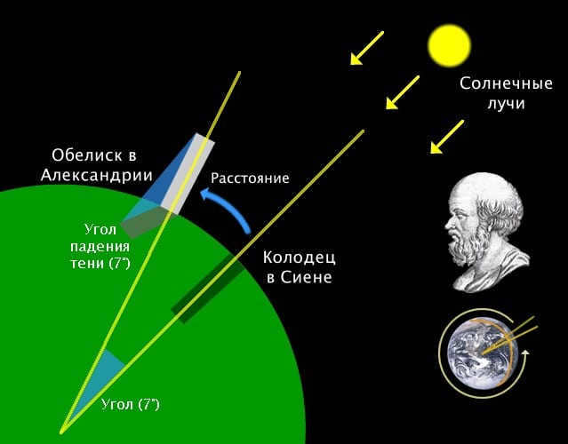
Eratosthenes conducted a measurement of the Earth’s circumference.
Eratosthenes calculated the length of the Earth’s circumference, which turned out to be slightly less than the actual value. This discrepancy was not due to inaccurate calculations, as this method of determining the Earth’s circumference is quite precise. During Eratosthenes’ time, the exact distance between the two cities was unknown. Additionally, the fact that the two cities were located on different meridians was not taken into account.
In the Middle Ages, the church prohibited any references to such research. It was not until the 16th century, with Magellan’s circumnavigation of the globe, that it was confirmed that the Earth is indeed round and that its circumference is approximately 40,000 kilometers.
Calculating a Planet’s Radius and Diameter
Determining the radius and diameter of a planet is a relatively simple task. In order to do so, you can utilize the following formulas: d=l/π and r=½*π. Here’s what each letter represents:
- d – diameter;
- l – length of the circle;
- r – radius (a line drawn from the center to any point on the circle);
- π is a mathematical constant approximately equal to 3.14.
Broadcasting the Earth from space online
Physical characteristics of our planet
The Earth is the fifth largest planet in the solar system.
Temperatures on the Earth’s surface can range from -89.2 to +56.7 degrees Celsius.
The equatorial radius of the Earth measures 6378.1 kilometers.
The Earth has a surface area of 510.072 million square kilometers.
The average density of the Earth is 5.5153 grams per cubic centimeter.
The acceleration of free fall on Earth is 9.78 meters per second squared or 0.99732g.
The mass of the Earth is 5.9726 x 10^24 kilograms.


