
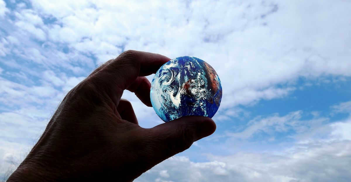
Among the celestial bodies in our solar system, Earth stands out as an exceptional planet. Its origin can be traced back to a solar nebula approximately 4.54 billion years ago, making it a truly ancient entity. What sets Earth apart from its planetary counterparts is its remarkable ability to sustain life. This can be attributed to a variety of factors, with two key elements being its unique atmospheric composition and the abundance of water that envelops approximately 75% of its surface. This fortuitous combination provides the perfect conditions for life to flourish on this extraordinary planet.
The configuration of the planet
Initially, early explorers held the belief that the Earth was a circular object floating atop a body of water. This notion encompassed both the perceived shape and size of our planet. Unfortunately, the absence of proper measuring tools hindered any attempts to visually discern the curvature of the Earth’s surface. It wasn’t until advancements in the fields of astronomy and geography that the flat Earth theory began to lose credibility among scientists.
During the 7th century BC, the ancient Greek philosopher Pythagoras proposed the idea that the Earth possessed a spherical configuration. Later, in 330 B.C., Aristotle presented compelling evidence supporting this notion. Finally, in the 17th century, Isaac Newton discovered the law of universal gravitation, further solidifying the theoretical impossibility of the Earth having a ball-like shape.
When a planet rotates, it experiences centrifugal force, which causes it to stretch at the equator and compress at the poles. As a result, its shape deviates from being perfectly round and becomes more like an ellipsoid. However, even an ellipsoid has a specific shape, unlike the Earth, which is not perfectly shaped. The presence of irregularities such as mountains and depressions distorts the Earth’s shape. A surface with these distortions is referred to as a geoid, which translates from Greek as “earth-like”.
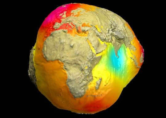
A geoid represents a fictional, even Earth surface that experiences a consistent perpendicular gravitational force. This force remains constant in all locations. However, the Earth’s actual shape differs from the geoid, as it undergoes minor changes due to external and internal influences.
In everyday life, we typically visualize the Earth’s shape in accordance with what we see in images. This conventional representation facilitates mathematical calculations and is therefore frequently employed.
From our perspective as inhabitants, the Earth appears to be vast. However, when compared to other celestial bodies, our planet is relatively small in size. In the solar system, the Earth is only the fifth largest. Nevertheless, it still holds the title of being the largest planet within the Earth group.
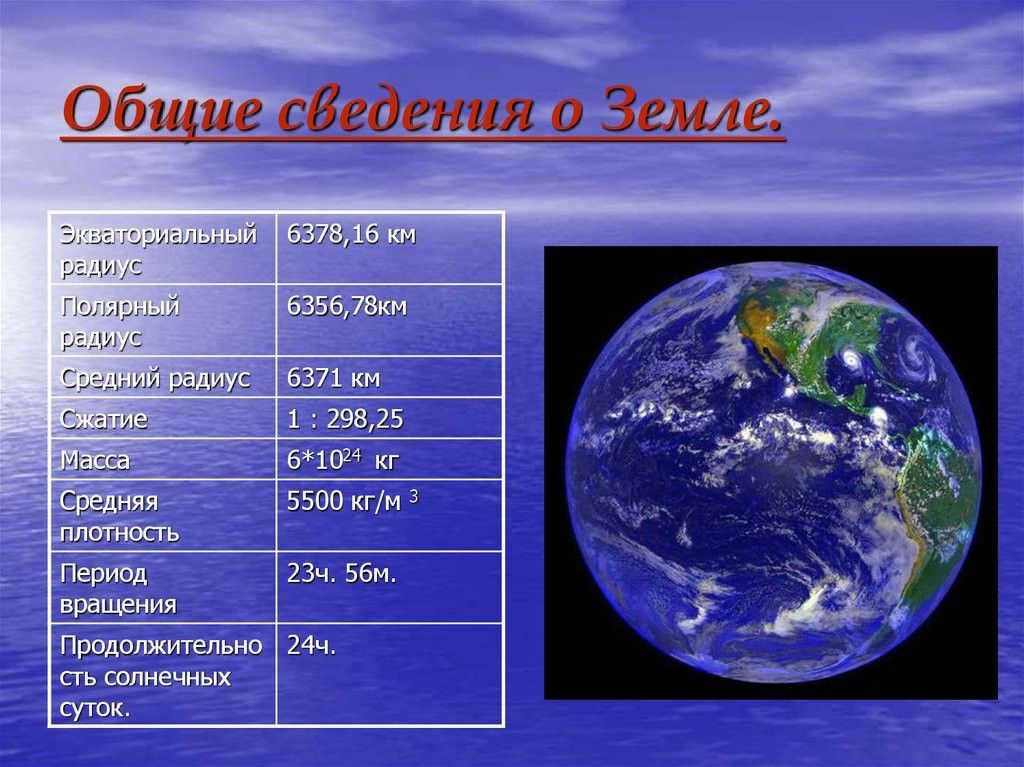
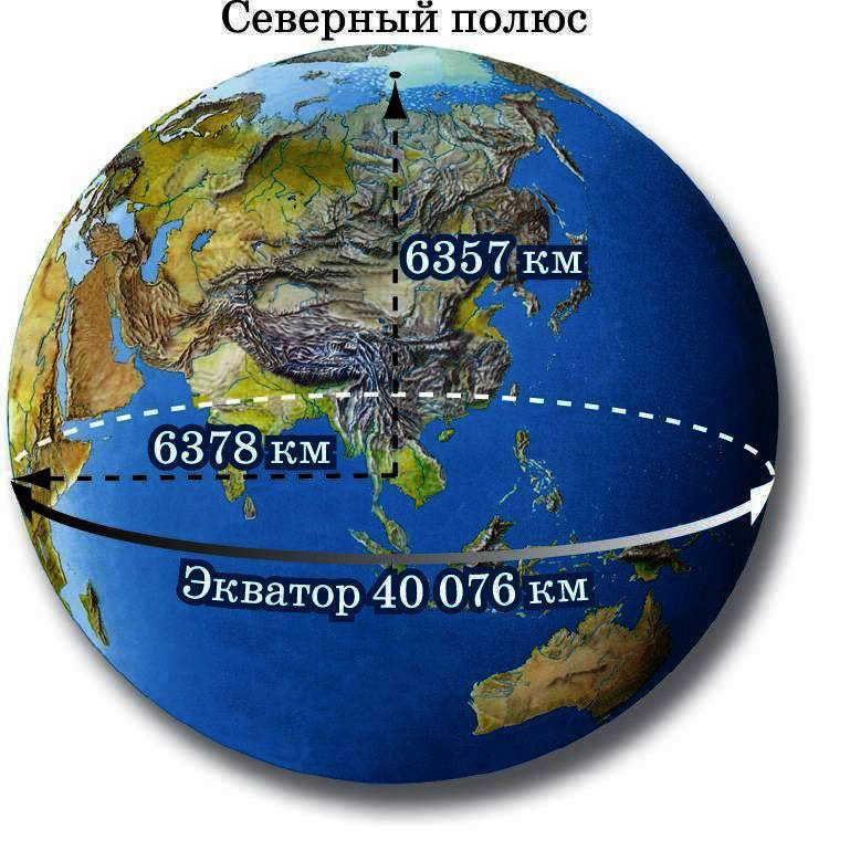
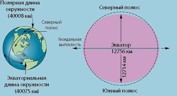
- The Earth has an average radius of 6,371 kilometers from its surface to its center. However, the equatorial radius is slightly larger at 6,378 km, while the polar radius is slightly smaller at 6,357 km.
- The Earth has an average diameter of 12,742 km. The equatorial diameter is more precise at 12,756.2 km, while the polar diameter is 12,713.6 km.
- The Earth has a total area of 510 million km2, with only 149 million km2 being land area.
- The Earth has a volume of 1,083 billion km3.
- The circumference of the Earth is approximately 40,075 km.
- The density of the Earth is 5.5 g/cm3.
- The mass of the Earth is approximately 5.97 x 10^24 kg.
All of these numbers may seem enormous, but when compared to the Sun, our planet is quite small. The volume of the Earth is 1.3 million times smaller than that of the Sun, and it is 330,000 times lighter.
In addition to the basic parameters, our planet possesses various other unique characteristics:
- The Earth is situated approximately 150 million kilometers away from the Sun.
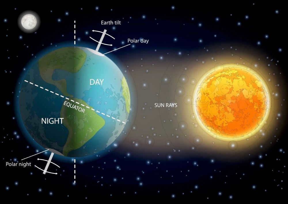
- The Earth’s axis is tilted at an angle of around 23.44 degrees, resulting in the occurrence of different seasons.
- The Earth completes one revolution around the Sun in 365 days, 5 hours 48 minutes 46 seconds.
- It takes the Earth approximately 23 hours 56 minutes 4 seconds to complete one rotation on its axis.
- The average temperature on Earth is approximately 15 degrees Celsius.
- About 71% (361 million square kilometers) of the Earth’s surface area is covered by water. However, only 3.5% of this water is drinkable.
- The Earth’s atmosphere consists of 78% nitrogen and 21% oxygen.
- The Moon is the nearest celestial body to Earth and the only natural satellite.
How to determine the radius and diameter of a celestial body
Calculating the radius of planets is a crucial task in the fields of astronomy and cosmology.
The radius of a planet refers to the distance from its surface to its center. Various methods can be employed to ascertain this distance. In order to facilitate calculations, celestial bodies are often approximated as spheres. To determine the radius and diameter of a planet, the following formulas can be utilized:
- D – diameter;
- L – circumference;
- r – radius;
- π represents a numerical constant equal to 3.14.
By utilizing a singular formula, it is possible to perform these calculations. Since radius and diameter are interconnected, it is sufficient to calculate one parameter and subsequently derive the other.

How long is the Earth’s equator in miles and kilometers?
The length of the Earth’s equator is a crucial measurement used in astrology, astronomy, geography, and geodesy. Precision in calculations is of utmost importance.
Based on the most precise calculations, the distance is approximately 40075 kilometers or 24901 miles.
Why the Earth does not have a perimeter
The Earth lacks a perimeter due to the impossibility of calculation. Perimeters can only be calculated for flat geometric figures like triangles, squares, and polygons. This calculation involves adding up the lengths of all sides. However, the Earth is a voluminous and shaped body, incapable of being flat. Consequently, the notion of an “Earth perimeter” is nonsensical.
The Evolution of Calculations
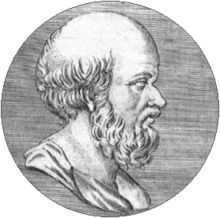
In ancient times, there were efforts to ascertain the dimensions of the globe. Eratosthenes of Cyrenaica, an ancient Greek mathematician, was able to achieve quite precise measurements in the 3rd century BC. He utilized a special instrument called the scaphysis, which consisted of a long needle and a bowl. With this tool, he attempted to determine the angle of the Sun in the sky. By establishing this angle, he was able to calculate the Earth’s radius, the length of the equator, and the circumference of the circle. According to his calculations, the circumference measured 40,000 kilometers and the radius was 6,366 kilometers.
An additional endeavor to determine the Earth’s dimensions was undertaken by Posidonius (135 – 51 BC), an ancient Greek astronomer. He calculated the circumference of the Earth, although his results were slightly less accurate, measuring 38,400 kilometers.
Around 830 AD, a team of Muslim astronomers, commissioned by Khalifa Al-Mamun, made an effort to ascertain the Earth’s circumference. The result they achieved was approximately 15% off from the modern value. However, given the limitations of that era, more precise measurements were not possible.
In the early 17th century, Dutch geographer W. Snellius introduced a new approach for calculating vast distances. To ensure accuracy, the measurements had to be taken without any obstructions along the way. This method, known as triangulation (derived from the Latin word “triangle”), proved to be highly effective in determining coordinates and distances. It remained a fundamental measurement technique in geodesy until the late 20th century.
Determining the Earth’s parameters was a challenging endeavor for ancient scientists. One of the pioneers in this field was Eratosthenes, an astronomer and geographer who successfully measured the Earth’s circumference along the equator.
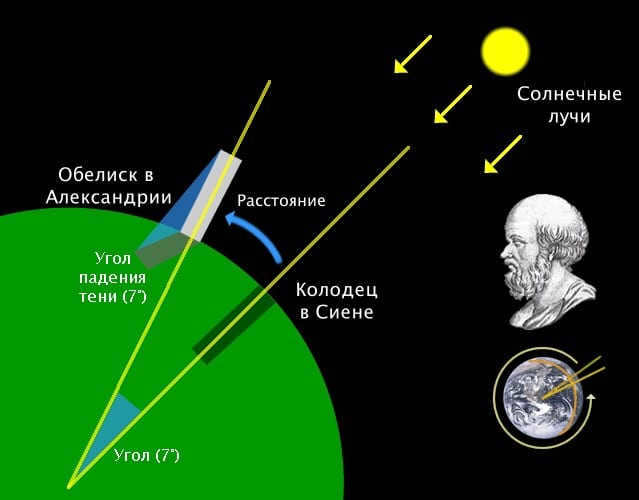
Eratosthenes made an interesting observation in Alexandria. He noticed that objects in the city always cast shadows, even on solstice days. However, in Siena, there were no shadows from objects. In fact, the sun’s rays directly illuminated the bottom of deep wells in Siena, indicating that the sun was at its zenith in this part of the planet.
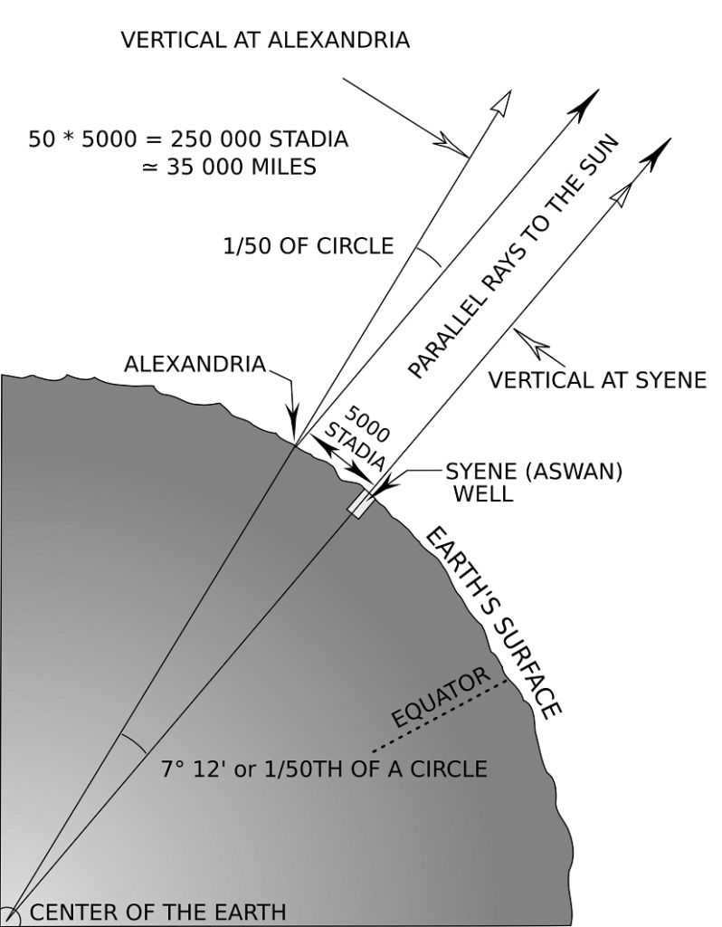
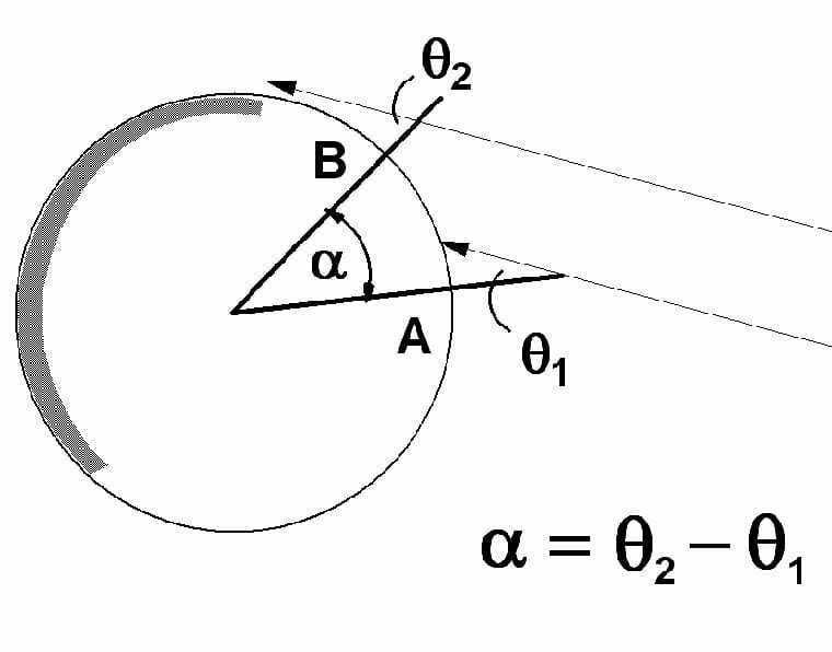
On June 19, 240 BC, Eratosthenes took the initiative to measure the shadow cast by the obelisk located in the town square of Alexandria at noon. By knowing the height of the obelisk, he was able to calculate the length of the line connecting the top of the obelisk with the endpoint of the shadow. This calculation resulted in the creation of an imaginary triangle. Utilizing the principles of geometry, Eratosthenes determined the angles of this triangle. After completing all the necessary calculations, Eratosthenes discovered that the angle of deviation between the obelisk and the sunbeam was approximately 7 degrees. This indicated that Alexandria was positioned 7 degrees away from Siena. It is important to note that this angle equates to approximately 1/50th of a full circle (360 degrees divided by 7 degrees is approximately equal to 1/50).
The distance between Siena and Alexandria was determined based on the number of days it took for the camels to travel between these cities, amounting to 5000 stadia. Using this data, Eratosthenes calculated that the circumference of the Earth is equal to 250000 stadia (5000-50=250000), which roughly corresponds to 40 thousand kilometers. These calculations were quite accurate for that time period.
In the Middle Ages, such research and references to them were prohibited. It was only through the circumnavigation of the globe by F. Magellan in the 16th century that it was finally confirmed that our planet is round and that Eratosthenes’ calculations were correct.
Video about Eratosthenes and his method for calculating the Earth’s circumference
Exploration in Russia
The Earth’s parameters have been extensively studied by Russian scientists. In the 19th century, the Pulkovo Observatory was the site of research to determine the length of the equator. This project was known as the “Russian Arc” or “Struve Arc.” Its objective was to measure one degree of the meridian arc using the triangulation method. Professor V. Я. Struve, an expert in Astronomy and Geodesy, spearheaded this endeavor.
There were 265 wooden towers (signals) constructed across 10 different countries in order to carry out the measurements. The stretch from Ukraine to Norway, spanning a distance of 2820 kilometers, took the form of a series of 258 isosceles triangles. Each tower was strategically placed so that it had a clear line of sight to at least four other towers. The selection of construction sites was done with great care. These wooden structures, reaching heights of up to 44 meters, were built entirely on site without the aid of any machinery.
The margin of error in the measurements was minimal, as evidenced by modern satellite analysis. The data obtained from these measurements allowed experts to determine the size of the Earth and validate existing theories about its shape.
The significance of the Struve Arc cannot be overstated. It is akin to Mendeleev’s periodic table for chemists. These data were instrumental in the creation of topographic maps. The calculations from that era served as the foundation for the development of more advanced navigation instruments and further exploration.
In 1940, the USSR Geodesy Research Institute undertook a project to determine the Earth’s shape. Through the efforts of F.N. Krasovsky and his student A.N. Izotov, the shape and dimensions of the Earth’s ellipsoid were calculated. Krasovsky’s ellipsoid parameters were subsequently adopted as the standard for use in cartographic and geodetic works throughout the USSR.
Fascinating Facts about the Equator of our Planet
The equator is a remarkable and truly unique location that never fails to inspire awe and wonder. Here, the Earth showcases its breathtaking beauty and gives rise to a multitude of fascinating phenomena:
- The equator stands as the longest parallel and roadway on our planet, stretching endlessly across its surface.
- At this remarkable line, the Earth reaches its pinnacle of rotational velocity, surpassing even the speed of sound.
- Walking along the equator with closed eyes and arms outstretched becomes an impossible feat for most, as the opposing rotational forces of the hemispheres pull in conflicting directions, making it challenging to maintain equilibrium.
- The equator is often mistakenly referred to as the hottest place on Earth, but there are deserts that experience much higher temperatures.
- At the equator, the duration of the day and night is equal. However, tourists who visit during the summer may find the days to be too short.
- When the Sun is directly overhead at the equator, its rays fall perpendicular to the ground.
- Contrary to popular belief, the equator is not the hottest place on Earth. Some deserts experience even higher temperatures.
- On the equator, there are no distinct seasons as we know them. It is summer-like all year round, and the difference between day and night temperatures is minimal (around 24°C). This region also receives the highest amount of ultraviolet light.
- These areas are known for their high levels of precipitation, receiving up to 10,000 mm of rainfall per year. The rain showers typically occur in the afternoon on a daily basis.
- The equatorial rainforests are dense and impenetrable, with layers of thickets and intertwined lianas. Palm trees and tall trees with valuable wood reach high above, creating an “evergreen canopy”. The arrangement here is vertical, not horizontal, as trees compete for a glimpse of the sky.
- Despite covering only 5% of the Earth’s surface, the equator is home to half of the planet’s animal species. Each species inhabits a different “floor” of the forest, or migrates between the lower and upper levels.
- The equatorial realm of birds is inhabited by 85 species, each displaying brilliant and vibrant colors.
- Among the unique features of the equator is the Congo River, the only river in the world that crosses the equator twice.
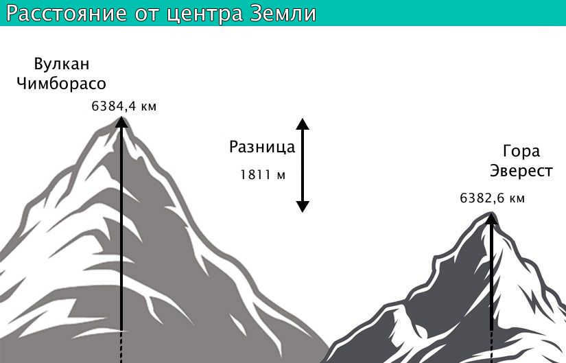
- While Mount Everest (8849 m) is widely known as the highest mountain in the world, Ecuador’s Chimborazo Volcano (6267 m) claims the title of the highest point in Ecuador.
- The Cotopaxi Volcano is a majestic peak enveloped by perpetual ice. Its name, “Brilliant Mountain,” perfectly captures its stunning beauty. From a distance, the sun’s rays are refracted and create a mesmerizing shimmer.
- Chimborazo, on the other hand, is a dormant volcano. With its summit reaching 6267 meters above sea level, it holds the distinction of being the farthest point from the center of the Earth.
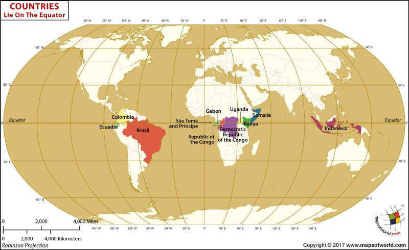
Countries located on the equator
Spanning the entire globe, the equator cuts across the surface of the Earth’s waters, intersecting Lake Victoria and the Congo River. Meandering back and forth between the water’s edge, it traverses through the Asian landmass and two continents (Africa and South America), intersecting 33 islands.
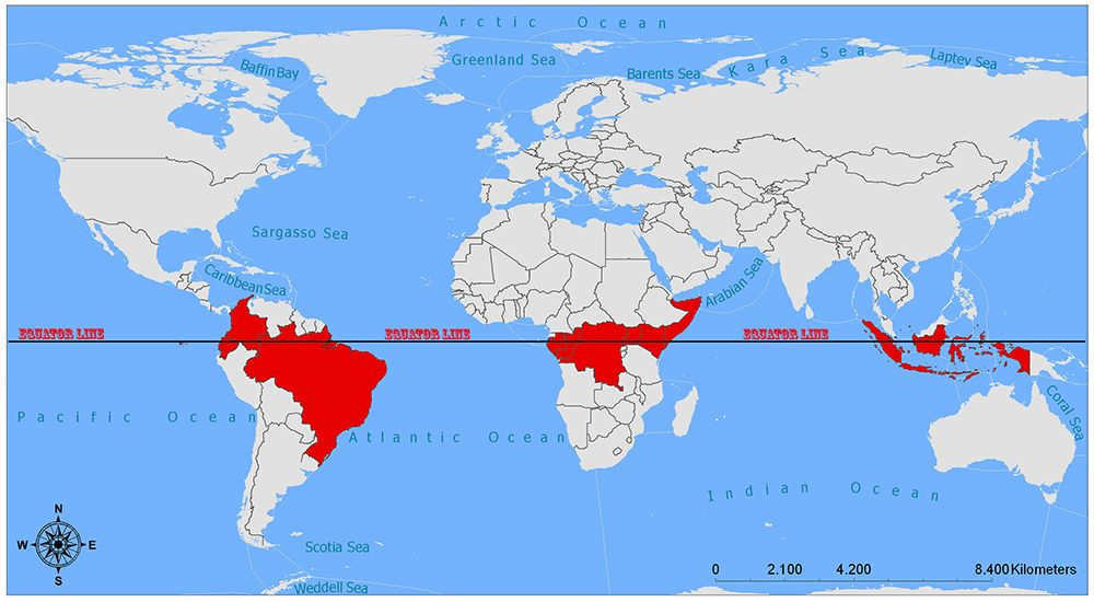
There are 14 countries located at the latitude of the equator, but only one of them is recognized as the central point.
- Ecuador, which means “equator” in Spanish, is considered the “Center” of the world. This country produces the most expensive chocolate in the world (a single bar can cost several hundred euros). Here, you can only taste a unique fruit juice called “naranilla” that combines flavors of peach and citrus. In the city of San Antonio, which is 20 km away from the capital, there is a well-known monument called “The Middle of the World”. This 30-meter monument stands on a yellow line drawn on the ground, symbolizing the equator – the middle of the world. Tourists often take photos here, standing with one foot in the Southern Hemisphere and the other in the Northern Hemisphere.
- Colombia is a nation named after Christopher Columbus. Because of its close proximity to the equator, it experiences a consistent climate with no seasonal changes and year-round sunshine. The coastal regions are characterized by tropical heat, while the mountainous areas are blessed with snowy landscapes. Travelers visit Colombia to witness the vibrant Festival of Flowers and immerse themselves in the enchanting Legends of Wayenato music festival.
- Brazil is a captivating country where summer begins in mid-December and winter arrives in mid-June. In the city of Makapa, you’ll find the remarkable Zeran soccer stadium, which is built right on the Earth’s equator. The line dividing the halves of the field aligns almost perfectly with the equator. The annual Brazilian carnival, a lively celebration of dance and culture, attracts an immense crowd of tourists every year.
- USA (Baker Island) – situated in the central region of the Pacific Ocean near the equator, this island remains unpopulated due to the absence of accessible freshwater sources.
- Indonesia – a nation of diverse cultures and incredibly welcoming people. It spans across both hemispheres, encompassing a total of 17,508 islands, of which only 6,000 are inhabited. This country holds a sense of allure and enigma, with its pristine shorelines, national parks, temples, volcanoes, and countless captivating destinations. Here, you can find the world’s largest flower, which emits a strong fragrance and can grow up to 8 meters tall. Additionally, Indonesia boasts a lake that changes colors and serves as a habitat for the Komodo dragon, the largest lizard on the planet.
- The Maldives is a nation made up of 1,192 small islands, known as “coral” islands. The unique beauty of the Maldivian beaches, with their pristine white sands, is unmistakable. For those who love exploring the underwater world, the Maldives offers a plethora of coral reefs and caves to discover.
- Kenya, a small country that straddles the equator, is often referred to as the “navel of the Earth”. Its tropical climate, diverse topography, and strategic location make it truly one-of-a-kind. In Kenya, you can have the extraordinary experience of seeing a giraffe, a flamingo, a penguin, and a giant tortoise all within a few meters of each other. Alternatively, you can take a thrilling hot-air balloon ride for a bird’s eye view of the incredible wildlife.
- Somalia, according to archaeologists, is one of the oldest human-inhabited territories in the world. However, due to ongoing conflicts and political instability, tourism is not well-developed in Somalia. Only the most adventurous and daring individuals are drawn to the constant danger and excitement of this region.
- The Republic of Congo is a land of lush tropical rainforests and fascinating African wildlife. Within its untouched territories, you can find the elusive bonobo monkeys, a rare and endangered species.
- São Tomé and Príncipe, a small island nation, offers a serene escape from the bustling world. With the refreshing ocean breeze and the stunning beauty of its natural surroundings, it is an ideal destination for a peaceful beach vacation or a tranquil retreat under the shade of palm trees.
- Gabon is renowned for its breathtaking landscapes, including dense forests, picturesque lagoons, and pristine white beaches. The country’s national parks are home to magnificent forest elephants and captivating sun-tailed monkeys. At night, you can witness the mesmerizing sight of sea turtles nesting on the beach.
- Uganda, often referred to as the “Pearl of Africa,” is a country renowned for its stunning landscapes and diverse wildlife. The country’s national reserves are home to the endangered mountain gorillas, making it a popular destination for nature enthusiasts. A must-visit spot in Uganda is the charming “Equator Line” diner, which is situated along the highway and straddles both hemispheres. Two impressive rings mark the equator line, running through the center of the diner and its main entrance.
What is the duration of a complete circumnavigation of the Earth on foot?
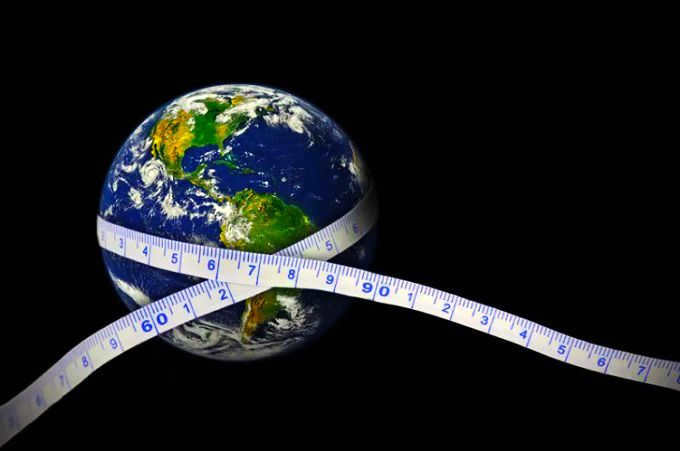
Circumnavigating the Earth is no longer a novelty. It has been accomplished in the past and continues to be achieved today. Any individual in good health can embark on a journey around the world. How many kilometers is the Earth’s circumference? With a strong physical condition, it is possible to conquer the distance of 40075 km and complete a full circumnavigation of the Earth.

If you were to walk approximately 40 kilometers every day, moving at an average speed of 5 km/h for 8 hours, it would take you around 1002 days (equivalent to 2 years and 9 months) to complete the entire journey. This may sound like a feasible plan in theory. However, the reality is that it is impossible to walk around the Earth’s circumference due to various obstacles.
Firstly, it is important to note that the equator, which marks the Earth’s circumference, is not a designated pedestrian path. It is merely a conceptual line. Therefore, attempting to walk along the equator would not be possible.
Furthermore, even if we were to disregard this limitation, there are numerous geographical features such as dense forests, expansive deserts, and towering mountains that would pose significant challenges to a walking journey. While it may be possible to navigate through these obstacles on foot, the biggest obstacle would be crossing the vast oceans. Walking across oceans is simply not feasible.
Therefore, it is safe to say that no traveler has ever been able to complete a walking trip around the Earth’s circumference. The total distance required to cover such a journey remains unknown.
Video about the equator of the Earth
In terms of practical significance for scientists, the measurement of the Earth’s diameter is determined by obtaining the circumference of the planet along the equator.
The primary characteristics of Earth
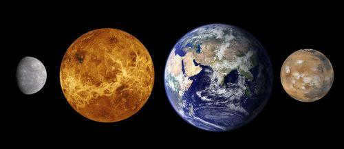
Planet Earth has an estimated age of at least 4.5 billion years. It belongs to the category of terrestrial planets, along with Mercury, Venus, and Mars. Unlike the gas giants (Jupiter, Saturn, Neptune, Uranus), these planets are predominantly composed of rock and have a thin surface layer. Among the terrestrial planets, Earth is the largest and ranks fifth in size within the entire solar system.
One distinguishing feature of Earth is the presence of life. This can be attributed to several factors:
- The distance from the Sun, which is approximately 150 million kilometers.
- The surface temperature, which averages at +13°C. The minimum temperature does not go below -90°C, while the maximum can reach up to +60°C.
- The abundance of water, which covers 71% of the planet’s surface and serves as the foundation for life.
- The composition of the atmosphere, which consists of 78% nitrogen, 21% oxygen, and 1% argon.
- The mass of the Earth is approximately 5.9722±0.0006×10^24 kg;
- The volume of the Earth is approximately 1.08321×10^12 km³;
- The density of the Earth is approximately 5.514×10 g/cm³;
- The circumference at the equator is approximately 40075.16 km, and the diameter is approximately 12756.1 km;
- Between the poles, the Earth has a smaller circumference of approximately 40008 km and a diameter of approximately 12713.5 km.
The Earth is unique because it is the only planet with a solid inner core, which makes it the densest. The inner core occupies about 30% of the Earth’s volume, while the liquid mantle covers 70-80% of the volume and the crust only 1%.
The Earth has one satellite, the Moon, which is located at an average distance of 384.4 thousand kilometers. The Earth orbits around the Sun in a distance of approximately 939120 million kilometers and completes one revolution in 365.3 days. The Earth also rotates around its own axis, completing one rotation in approximately 23.9 hours.
The form of the planet
Our planet is referred to as a sphere, although this description is not entirely accurate in terms of geometry. The variations in ocean trenches and mountain peaks do not significantly impact the overall shape. The difference in height between the lowest point (Mariana Trench) and the highest point (Mount Everest) is only 19 km.
The shape of the Earth is primarily influenced by gravity. The gravitational pull towards the center (core) causes the planet to contract, resulting in a spherical form. The centrifugal force generated by the planet’s rotation is greatest at the equator. As a result, the equator has the largest circumference and diameter.
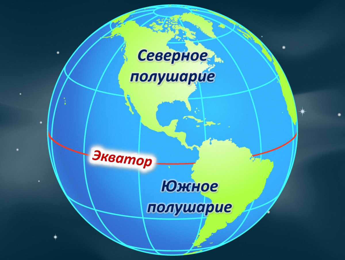
What is the equator and why is it important?
The equator is an imaginary line that runs along the Earth at an equal distance from the North and South poles. It is a vital reference point for navigation and geography. Due to the Earth’s spherical shape, the equator is the longest parallel line. The position of the equator varies slightly between 22-24.5 degrees in relation to the plane of the Earth’s orbit, which is influenced by the gravitational pull of other planets and the Sun.
One unique characteristic of the equator is that it experiences equal day and night throughout the year, with no significant deviation. During the equinox, which occurs twice a year, the sun’s rays are directly overhead at the equator. This results in the equatorial regions receiving the highest amount of ultraviolet light. Consequently, these areas have a constant summer-like climate, with hot and humid air due to continuous evaporation.
Objects are positioned using parallels and meridians, which are utilized for navigation in the air, on land, and in water. Moreover, these lines also delineate climatic and time zones.
Measuring the Earth’s Circumference: A Geometric Approach
When it comes to calculating the Earth’s circumference along the equator, there are specialized instruments and space satellites that can be used. However, it is also possible to obtain this data without relying on complex tools by applying principles of geometry. One of the earliest recorded attempts at such a measurement was made by the Ancient Greek scientist Eratosthenes.
According to legend, Eratosthenes was informed by travelers that on the day of the summer solstice, they noticed that the bottom of the deepest wells in Siena, a city located 500 miles south of Alexandria, were illuminated and objects did not cast any shadows. This indicated that the sun was directly overhead. In contrast, in his hometown of Alexandria, objects did cast shadows and the sun did not reach the bottoms of deep wells.
An angle of 7° represents approximately 1/50th of a complete circle, which always measures 360°. The astronomer proceeded with his calculations, multiplying the distance to Siena by 50. The Earth’s circumference was estimated to be 25,000 miles. Recent research has revealed that the scientist was not far off: the equatorial circumference of the planet is actually 24,894 miles or 40,075 km.
Eratosthenes’ slight discrepancy can be attributed not to the primitiveness of his calculations, but rather to the lack of precise information regarding the distance between cities. In those times, the measurement was based on the number of days it took a caravan to travel the route.
Another factor contributing to the inaccuracy is the fact that Alexandria and Siena are situated on different meridians. In present-day calculations, the circumference is determined between objects on the same meridian.
Calculating Radius and Diameter
When it comes to determining the radius and diameter of a globe, it’s a straightforward process if you know the circumference. You can use the following formulas:
- The diameter (d) can be calculated by dividing the length of the circle (l) by π (approximately 3.14). The diameter connects opposite sides of the circle and passes through the center.
- The radius (r) is equal to half the circumference (l) divided by π. The radius is the line drawn from the center to any point on the circle.
- π is an infinite number that is approximately equal to 3.14. The more decimal places you use, the more accurate your calculation will be.
You don’t necessarily need to use both formulas. The diameter and radius are interconnected. Once you calculate one parameter, you can determine the other. The diameter is always twice the radius, and vice versa.
How long does it take to circumnavigate the planet on foot?
To determine the time it takes to go around the Earth on foot, we need to calculate the length of the equatorial circumference in kilometers and take into account the estimated speed of the pedestrian. The formula used is: t=S:V. Let’s break it down:
The equatorial circumference of the Earth is approximately 40,075 kilometers. Assuming a pedestrian’s average speed is 6 km/h, we can substitute these values into the formula: 40075/6=6679 hours. Converting this to days, it comes out to be approximately 278 days.
However, it’s important to note that no one can walk continuously without stopping. If we assume that a pedestrian walks for 6 hours a day, it would take 4 times longer – around 1112 days. This is equivalent to approximately 3 years.
Fascinating information about the Earth’s equator
The region surrounding the equator is known for its warm and humid climate. It boasts the most diverse and abundant flora and fauna in the world, with dense forests and some areas that are nearly impossible to navigate. The summer season lasts all year round, with average temperatures ranging from +25 to +30°C. The temperature at night doesn’t vary much from the daytime, thanks to the constant warmth from the sun. Rainfall is a regular occurrence, with showers happening almost every day.
This unique climate attracts tourists, although not all countries have the same conditions. The Maldives, Ecuador, Brazil, and Kenya are among the countries that receive the highest number of tourists each year, thanks to their desirable equatorial climates.
Equatorial countries also offer a range of geographical attractions:
- There are a total of 14 countries situated along the equator, with Ecuador being one of them and named in honor of this zero parallel. It is a remarkable feat for any traveler to have crossed all of these equatorial countries.
- With the exception of Gabon and Somalia, almost all equatorial countries have erected commemorative signs to mark the significance of the zero parallel. The most stunning ones can be found in Brazil and Ecuador.
- Within the Galapagos archipelago lies the active volcano, Wolf, which straddles both sides of the equator.
- In close proximity to Quito, the capital city of Ecuador, stands the snow-capped Cayambe volcano, reaching an impressive altitude of 4690 meters. Its slopes are perpetually covered in ice.
- The Congo River in Africa crosses the equator not once, but twice.
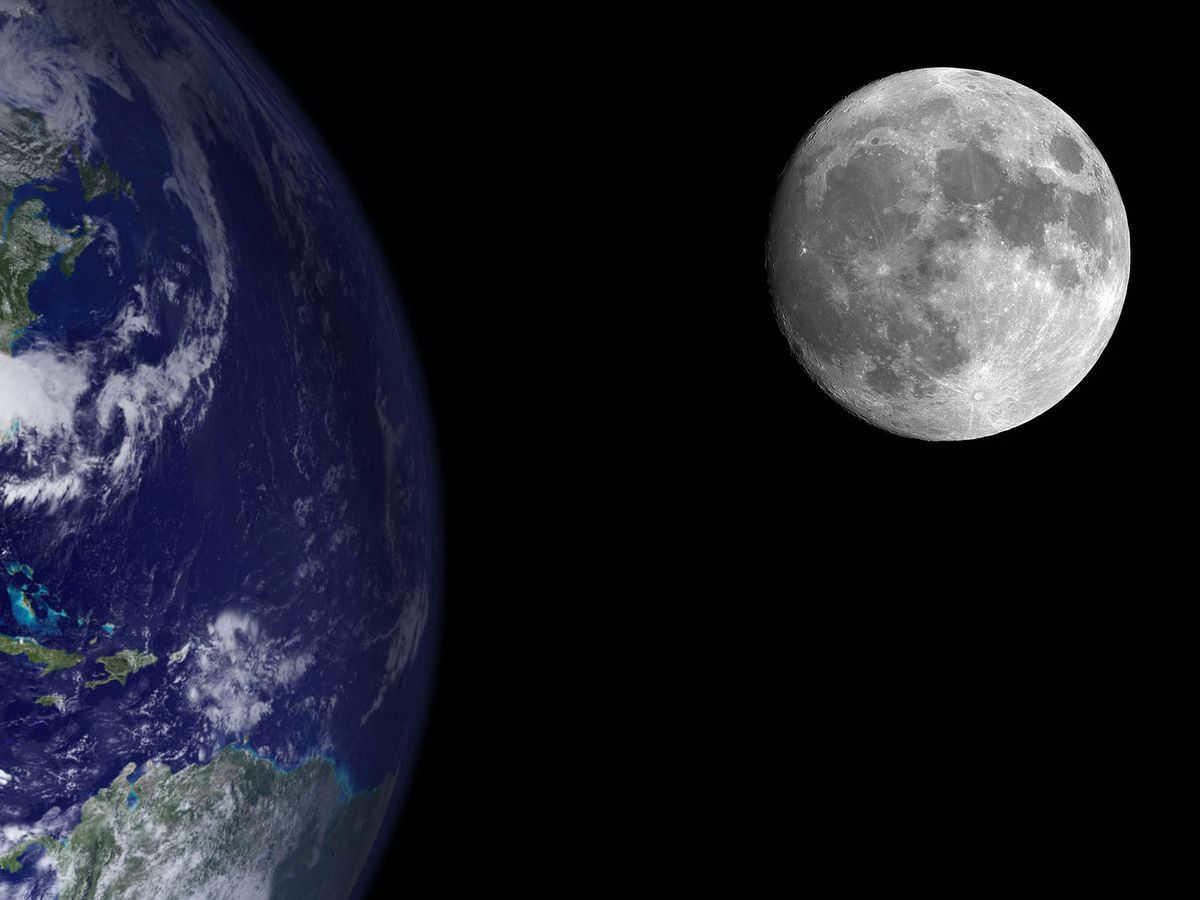
The Moon is one of the most prominent celestial bodies visible to the naked eye and it is also the nearest astronomical object to Earth. Throughout history, humans have been captivated by the Moon, creating myths and legends to explain its origins and the mysterious spots on its surface. One intriguing question that has fascinated many is whether the Moon or the Earth is larger. Thanks to advancements in space exploration, we now have precise measurements of the sizes of the Moon and the Earth, as well as the distance between them.
The sizes of the planet and its satellite
The Moon is an Earth’s natural satellite, with a diameter approximately four times smaller than Earth’s. Earth’s diameter is 12,742 km, while the Moon’s diameter is 3,474 km. The difference between these measurements is 3.6 times. The satellite’s diameter is 3/11 of Earth’s.
When compared to other celestial bodies, the Moon’s dimensions are relatively small:
- The Moon’s equatorial circumference measures 10,917 km;
- its average radius is 1,737 kilometers;
- and its total area is 38 million square kilometers.
The diameter’s size is approximately two times smaller than the distance between Moscow and Vladivostok.
The Moon’s area is 13.5 times smaller than that of Earth. If we compare only the lunar surface with Earth’s landmass, the satellite’s size would be 4 times smaller.
The Moon’s volume is 50 times less, which is 2% of Earth’s volume. The mass difference between the two celestial bodies is 80 times. These figures indicate that lunar rocks are less dense than Earth’s rocks. There may be voids inside the natural satellite.
The difference in size affects the gravitational force, which is 6 times weaker on the lunar surface compared to our planet. Under such conditions, 100 kg would weigh 16.7 kg. Consequently, a person on the Moon would have the ability to jump higher.
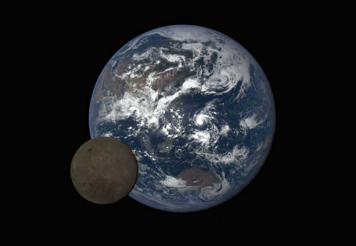
The diameter of the Moon measures 3474 kilometers, whereas the Earth’s diameter is 12742 kilometers. Credit: etointeresno.mirtesen.ru
Can the satellite undergo changes?
The physical characteristics of Earth’s satellite remain constant, but its apparent size when observed from the planet’s surface can vary. One of the factors contributing to these variations is the elliptical shape of the lunar orbit. Consequently, the satellite is positioned at different distances from the planet at different times. The farthest point is referred to as apogee, while the closest point in the orbit is called perigee. During perigee, the Moon appears larger from Earth compared to other days.
The phenomenon of a supermoon is separately explained, occurring when perigee coincides with a full moon.
The Moon doesn’t only appear larger when it is closest to Earth. There is a phenomenon called the moon illusion that remains unexplained. When the Moon is low above the horizon, it appears visually larger than when it is high in the sky. This optical illusion also applies to other cosmic bodies during sunrise and sunset. The moon illusion has been observed since ancient times, as evidenced by records in ancient chronicles.
There are various ways to visually compare the Moon and the Earth. One example is to compare a 5-ruble coin to a pea. However, the most accurate way to demonstrate the proportion between these celestial bodies is to compare a basketball to a tennis ball. The diameter difference between a standard basketball (24 cm) and a tennis ball (6.7 cm) is 3.6 times, which is the same as the difference between the Moon and our planet.
Using the sports ball example, we can not only appreciate the difference in size between the two celestial bodies, but also the distance between them. This distance is equal to 30 Earth diameters or, in the example, 30 basketballs, which is a little over 7 meters. By placing a tennis ball and a basketball 7.2 meters apart, we can visualize the difference in size between the Earth and the Moon and the vast distance that separates them.
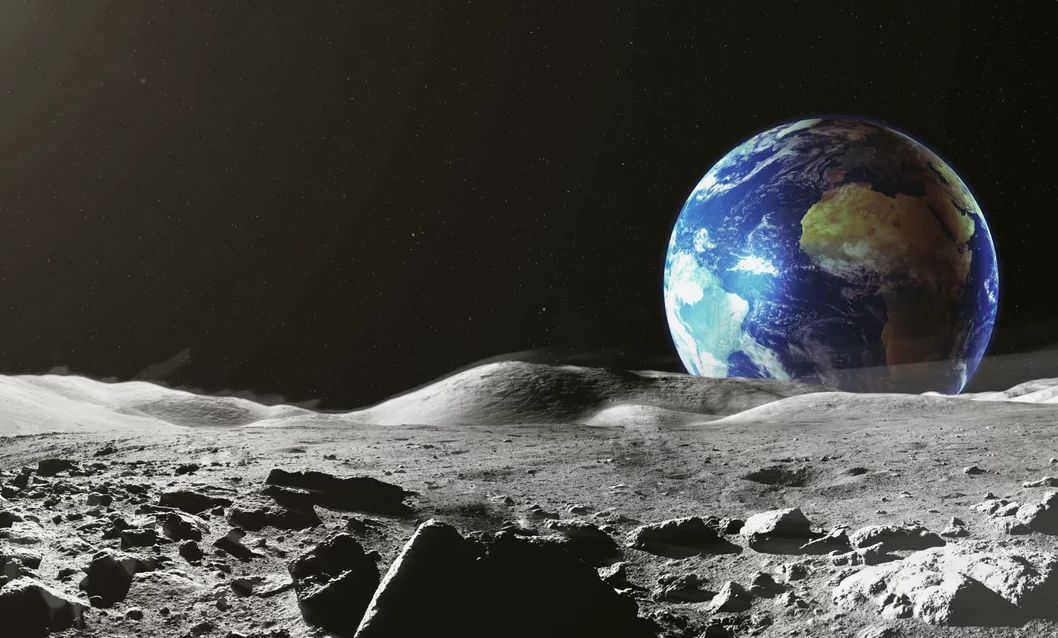
How the Moon Reveals the Earth’s Beauty
Stunning images captured by satellites and astronauts unveil an awe-inspiring perspective of our home planet from the lunar surface. The inaugural snapshot was taken in 1968 by the skilled crew aboard the Apollo 8 spacecraft, which gracefully orbited our celestial neighbor. This iconic photograph, aptly named “Earthrise,” forever etched in our collective memory the breathtaking sight of Earth emerging above the Moon’s horizon. Though Moon dwellers are unable to experience the daily spectacle of Earth’s sunrise and sunset like their terrestrial counterparts, a select few regions on the lunar surface offer glimpses of this extraordinary event. This unique occurrence transpires approximately once every lunar month, adding to the allure of our magnificent planet.
In 2015, NASA released an image showcasing the perspective of Earth as seen from the lunar surface. To achieve the final result, multiple frames were combined and color adjustments were made. Initially captured in black and white, the picture underwent color correction to portray the planet as it would appear to an observer on the Moon.
When viewed from the lunar surface, Earth appears 13 times larger and 43 times brighter than the Moon does from our own planet. This difference in brightness is attributed to the moon’s rocky terrain, which reflects less light compared to Earth’s various elements such as vegetation, water, ice, and deserts. Under certain conditions, such as when large deserts and polar caps are illuminated by the Sun while Earth is covered in clouds, our planet can appear as much as 55 times brighter than its satellite.
Primary characteristics of our planet
- The Earth’s diameter is 12756 km at the equator and 12713 km at the poles.
- The average radius of the Earth is 6371 kilometers, which is the distance from the surface to the core’s center. The equatorial radius measures 6378 km, while the distance to the Earth’s center at the poles is 6356.5 km.
- When measured around the equator, the Earth’s circumference is approximately 40075 kilometers, while around the poles it is around 40008 kilometers.
- The distance between the Earth and the Sun is approximately 150 million kilometers. This distance is crucial for the existence and sustainability of life on our planet. If the Earth’s orbit were to deviate by a mere few million kilometers closer or farther from the Sun, the conditions for the evolution of life would be significantly compromised.
- The Earth takes 365 days, 5 hours, 48 minutes, and 46 seconds to complete one revolution around the Sun. It also takes 23 hours, 46 minutes, and 4 seconds to make a full rotation around its axis. Over a span of 100 years, the speed of this rotation decreases by 0.017 seconds. If this trend were to continue, it would take approximately 140 million years for the length of a day to increase by one hour.
- The Earth’s axis of rotation is tilted at an angle of slightly over 23 degrees in relation to its orbital plane. This tilt is responsible for the changing seasons and the varying climatic conditions. If the tilt were to be slightly decreased or increased, the Earth would experience less favorable climate conditions, potentially leading to the formation of glaciers on larger parts of its surface.
- The average temperature on Earth is approximately 15 degrees Celsius.
- The composition of the Earth’s atmosphere consists of 21% oxygen and 78% nitrogen, which is a gas that has no biological effects.
- The Earth has a mass of approximately 6*10^24 kilograms.
- The volume of the planet is 1.08*10^12 cubic kilometers.
- The total area of the Earth’s surface is 510 million square kilometers.
- The density of the Earth is 5.5 grams per cubic centimeter.
- Among the celestial bodies, the Moon is the closest to the Earth. It has an average distance of about 384 thousand kilometers.
The form of the planet
When inquired about the form of the Earth, the majority of individuals will respond that it is round. However, this is an erroneous assumption. The planet is influenced by gravitational forces: the enormous mass gravitates towards the core, resulting in constant compression. The most powerful centrifugal force is produced due to the Earth’s rotation on its own axis – specifically at the equator.
The Earth can be described as an “irregular sphere”. Compression is the underlying cause for the equatorial diameter of the planet being slightly larger compared to the poles. Scientists define the shape of our planet as being similar to a “flattened ellipsoid”.
What is interesting is that, due to disregarding the compression of the Earth at the poles, the meter standard from 1795 was 200 microns shorter.
What is the purpose and significance of the equator?
The equator can be defined as an imaginary line that runs perpendicular to the Earth’s axis and is equidistant from the poles.
Along the entire length of the equator, the duration of day and night is equal. However, due to atmospheric refraction, the length of the day is slightly longer by a few minutes. The Sun reaches its zenith and its rays are directed perpendicular to the Earth’s surface twice a year, on the days of the equinoxes. The latitude at the equator is 0 degrees.
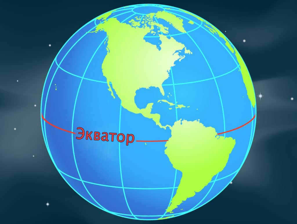
The equator plays a crucial role in determining the latitude of a geographic feature. Any point situated to the south of this imaginary line is considered to have a southern latitude, while objects located to the north of it are said to have a northern latitude.
Calculating the Earth’s Circumference
The size of the Earth can be measured. Advanced technology and satellites are utilized to determine the Earth’s circumference. However, prior to these advancements, mathematical measurement methods had to be employed. During the 18th century, scientists such as P. Meschen, A.M. Lejeandre, and C. Cassini employed the method of triangulation.
It would be convenient to use the imaginary figures to set up an angle gauge and determine the degrees of the angles. In one of the triangles, one side is measured along level ground, which will serve as the baseline.
To measure the length of the equator, the easiest method is to multiply the number of kilometers in one degree by 360.
When the measurement of the arc of the meridian is known, it becomes a simple task to determine the length of one degree. This technique forms the foundation of geodesy.
Calculating the Radius and Diameter of the Planet
Deriving the radius and diameter of the Earth is not a complicated process. The following formulas are utilized: d=l/π; r=½*π. The variables represent:
- d – diameter;
- l – length of the circumference;
- r – radius (a line extending from the center to any point on the circumference);
- π is an approximate value of 3.14.
The measurement of this quantity has been documented since ancient Greece. The ancient Greek mathematician, astronomer, and geographer Eratosthenes performed the necessary calculations. He observed that on June 21st, the solstice day, in Siena, which is located half a thousand miles from Alexandria, the bottom of wells were illuminated at noon and no shadows were detected from objects. This indicated that the sun was at its highest point in this part of the planet. However, in Alexandria, no such phenomenon occurred.
Using an obelisk in the city, Eratosthenes measured the shadow at noon on the summer solstice (he knew the obelisk’s height). This measurement revealed that Alexandria and Siena were separated by a distance of 7 degrees of latitude.
Eratosthenes’ calculation of the Earth’s circumference is slightly smaller than the actual circumference. This discrepancy is not due to inaccurate calculations; this method of determining the Earth’s circumference is quite precise. At the time of Eratosthenes’ calculations, the exact distance between the two settlements was unknown. Additionally, the scientist did not account for the fact that the cities are situated on two different meridians.
During the Middle Ages, the church prohibited references to such research. It was only in the 16th century, with F. Magellan’s circumnavigation of the globe, that it became evident that the Earth is indeed round and its circumference is approximately 40,000 kilometers.
Estimating the Time it Takes to Walk Around the Earth
If we consider the length of the Earth’s circumference along the equator, it becomes possible to calculate the duration required to complete a full lap on foot. Assuming an average walking speed of 6 kilometers per hour, we can utilize the formula t=S/V to determine that the journey would take approximately 6,700 hours, equivalent to 278 days.

This is the estimated time it would take for an individual to complete a continuous walk around the circumference of the Earth. Assuming the walker spends 6 hours per day walking, it would take approximately 1110 days, equivalent to over 3 years, to complete such a journey.
Fascinating facts about the Earth’s equator
The equator experiences a consistently hot and humid climate throughout the year. The forests found along the equator, such as the Amazon rainforest, equatorial Africa, and Indonesia, are known for their diverse range of plant and animal species. During the daytime, temperatures typically range between 25 and 30 degrees Celsius. Even at night, the temperature remains relatively warm as the Earth’s surface retains heat from the sun’s rays.
In addition, the equator possesses several intriguing geographical features:
- It passes through more than 30 islands.
- The equator intersects 14 different countries.
- One country, Ecuador, is named after the equator.
- Located near the city of Quito, the Cayambe volcano stands at a towering height of approximately 4.7 km, boasting a majestic peak adorned with eternal ice. This is particularly remarkable considering the equatorial climate’s consistent heat.
- The Congo River, coursing through the heart of the African continent, traverses the zero parallel on two occasions.
- Due to the Earth’s rapid orbit in this area, it is the optimal location for satellite launches, as they can attain velocity at an accelerated rate.
The Earth’s size is a crucial parameter in the field of astronomy and holds immense practical significance. It enables the determination of the Earth’s diameter and radius, which can be calculated through straightforward mathematical calculations.
What sets Earth apart is its distinction as the primary member of the terrestrial quartet (Mercury, Venus, Earth, and Mars), characterized by its relatively slender rocky composition, contrasting with the expansive gas giants (Jupiter, Saturn, Neptune, and Uranus). In terms of its mass, density, and diameter, Earth ranks as the solar system’s fifth most sizable celestial body.
With an estimated mass of 5.9722±0.0006×10 24 kg, Earth is the largest planet in the terrestrial group. It also has the largest volume among these planets, measuring at 1.08321×10⁶ km³.
Furthermore, our planet is the densest among the Earth-group planets due to its composition of crust, mantle, and core. The Earth’s crust is the thinnest layer, while the mantle accounts for 84% of the Earth’s volume and extends 2,900 kilometers beneath the surface. The core is what gives the Earth its density, as it is the only planet in the Earth group to have a liquid outer core surrounding a solid and dense inner core.
Earth has an average density of 5.514×10 g/cm³. Mars, the smallest planet resembling Earth in the solar system, has approximately 70% of Earth’s density.
The form of our planet
The reason why Earth’s circumference and diameter differ is because its shape is not a perfect sphere, but rather a flattened spheroid or ellipsoid. The planet’s poles are slightly flattened, resulting in a bulge at the equator. As a result, Earth has a larger circumference and diameter compared to a true sphere.
The equatorial bulge of Earth measures approximately 42.72 kilometers and is caused by the planet’s rotation and gravity. Gravity plays a significant role in shaping celestial bodies, causing them to contract and form a spherical shape. This is because gravity pulls the entire mass of the object towards its center of gravity, which in the case of Earth is its core.
Although local topography does have an impact on the Earth’s shape, its influence is minimal when considering the entire planet. The most significant variations in local topography can be seen in Mount Everest, the highest point above sea level at 8,848 meters, and the Mariana Trench, the deepest point below sea level at 10,994±40 meters. The difference between these two points is only approximately 19 km, which is relatively insignificant on a global scale. Taking into account the equatorial bulge, the highest point on Earth and the location farthest from its center is the summit of the Chimborazo volcano in Ecuador, which is the tallest peak near the equator with an elevation of 6,267 meters.
Geodesy, the scientific field responsible for measuring the size and shape of the Earth using surveys and mathematical calculations, plays a crucial role in studying the Earth’s dimensions.
Throughout the course of history, geodesy has held significant importance as ancient scholars and thinkers endeavored to ascertain the true shape of our planet. Aristotle, often regarded as the pioneer in this field, made the initial attempt to calculate the Earth’s size, thus earning the title of an early geodesist. Following Aristotle, the Greek philosopher Eratosthenes estimated the Earth’s circumference to be around 40,233 kilometers, a measurement that remains remarkably close to the current accepted value.
To investigate the Earth and employ geodesy, scientists frequently utilize the ellipsoid, geoid, and reference ellipsoid. An ellipsoid is an abstract mathematical concept that presents a streamlined, simplified depiction of the Earth’s exterior. It is employed to calculate distances on the surface without considering variables such as changes in elevation and topography. Acknowledging the actuality of the Earth’s surface, surveyors employ a geoid, a representation of the planet that is devised using the average global sea level and thus accounts for disparities in height.


