
The State Duma has received a proposal to reintroduce winter time. The deputies suggest setting the clock back one hour on October 26, 2014, and then keeping the time unchanged regardless of the season.

Furthermore, there is a proposal to reinstate the 10 time zones in Russia, as it was prior to August 2011. The Federation Council has shown its support for this bill. This reform will bring Russia’s time closer to the zone time.
What is referred to as astronomical time?
Astronomical time is often mistaken for zone time. It is believed that astronomical time aligns with the biological rhythm of human life, and it is natural and beneficial to live in accordance with it.
However, in today’s world, it is impossible to adhere strictly to astronomical time. This was a luxury that only our ancestors could afford, as they relied on the position of the Sun to determine the time even before clocks were invented. Specifically, they used a long pole that would cast a shadow on the ground, with 12 hours of the day corresponding to when the Sun was at its zenith and the pole did not cast a shadow.
The time determined by a sundial is known as astronomical or solar time. However, astronomical time is not constant and will vary even for the same location throughout the year, as the Earth rotates around the Sun.
Time Zone
The concept of time that we are familiar with is not directly related to the actual time measured by astronomical events. Instead, our daily lives are organized around a system of 24 hours, with each day ending at midnight. This system is known as civil time.
During the international congress held in Washington in 1884, it was agreed to divide the globe into 24 time zones. Each time zone is separated by one hour from the adjacent zones. The time within the middle of each time zone aligns with civil time, and this time is referred to as zone time throughout the entire region of the respective time zone.
Summer versus Winter Time
Due to various economic, political, and other factors, the current time can differ from the zone time by several hours. During the summer season, the clock hands are typically adjusted one hour ahead, while in winter, they are set one hour behind. This practice aims to optimize the use of daylight hours and promote energy conservation.
During the First World War, Europe implemented daylight saving time as a means to conserve energy resources. In 1917, Russia also adopted a system of summer and winter time.
Standard time
As a result of clock adjustments in 1930 and 1981, the USSR found itself two hours ahead of the time zone during summer and one hour ahead during winter. This time system became known as “decree time” due to its implementation by decree from the Council of People’s Commissars of the USSR.

In 1991, there were attempts to eliminate the concept of “decree” time, but this proposal was met with dissatisfaction from the general population and an increase in electricity usage. The reason for this was that individuals had to wake up long before sunrise in the morning and by the time they returned home from work in the evening, it was already dark. By 2009, when former Russian President Dmitry Medvedev initiated another time reform, approximately 60% of Russians were living under these circumstances.
What is the current time in Russia?
Currently in Russia, there is a permanent summer time, which is 1-2 hours ahead of the time zone. The winter time was abolished in 2011 by former President Dmitry Medvedev’s decree. However, not everyone supported this decision. In Moscow, central regions of the European part of Russia, western Siberia, eastern Krasnoyarsk Krai, and Kamchatka, the time is 1 hour ahead of the time zone. In other regions, the administrative time is 2 hours ahead of the time zone.
When could Russia switch back to winter time?
The proposal suggests adjusting the clocks on October 26th this year. However, it might not be possible to switch back to winter time immediately after the Sochi Olympics. Doing so earlier could pose difficulties, as the television broadcast schedule for the Olympic Games has already been finalized.
What exactly is zone time and how does it distinguish itself from winter and summer time?
The concept of zone time was implemented in Russia on February 8, 1919. A decree issued by the Council of People’s Commissars divided the nation into 11 distinct time zones. AiF.ru provides an explanation of what zone time entails and how it varies from the current time observed by Russians.
What was the process and timing behind the division of the world into time zones?
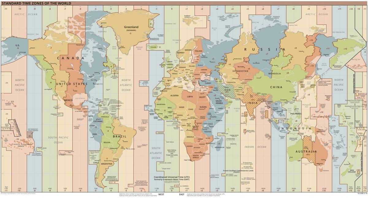
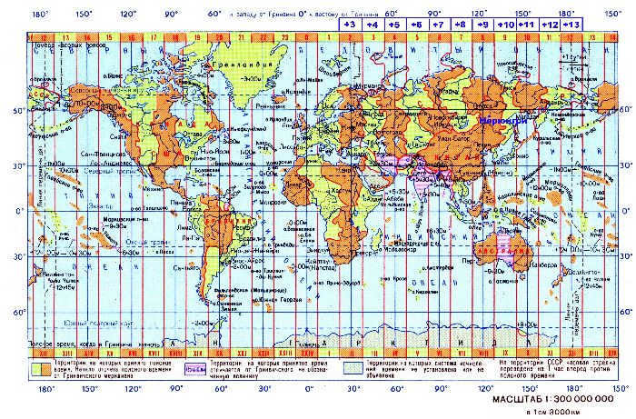
In 1884, during the International Congress held in Washington, a decision was made to divide the globe into 24 time zones. Each zone represents a one-hour difference in time from the adjacent zones.
The measurement of the time zones begins at the prime meridian of Greenwich, which serves as the zero point in the coordinate system. Each individual time zone spans approximately 15 degrees of longitude, although in many countries multiple zones are merged together for simplicity and ease of use.
When was the switch to zone time implemented in Russia?
On February 8, 1919, the Council of People’s Commissars issued a decree in the RSFSR, titled “On the adoption of the international system of time zones.” This marked the official transition to zone time in Russia, aligning it with the rest of the world.
Prior to the revolution, the Russian Empire followed local solar time, with unified St. Petersburg time being used at railway stations due to the development of railroads. To learn more about the differences between astronomical, solar time and zone time, click here>>.
In 1930 and 1981, the USSR changed its clocks, resulting in a time difference of two hours ahead in the summer and one hour ahead in the winter. This new time became known as “decree time” since it was introduced through a decree by the Council of People’s Commissars of the USSR.
In 1991, there were attempts to abolish decree time, but this caused dissatisfaction among the population and an increase in electricity usage. The reason for this was that people had to wake up well before sunrise in the morning, and by the time they returned home from work in the evening, it was already dark. By 2009, when former Russian President Dmitry Medvedev initiated another time reform, around 60% of Russians were barely able to see the sun during winter.
What is the current time in Russia?
At present, Russia follows a permanent summer time, which is 1-2 hours ahead of the time zone. The winter time was abolished in 2011 by former President Medvedev’s decree. However, not everyone was in favor of this decision. In Moscow, the central regions of the European part of Russia, western Siberia, eastern Krasnoyarsk Krai, and Kamchatka, the time is 1 hour ahead of the time zone. In other regions, the administrative time is 2 hours ahead of the time zone.
When will Russia go back to winter time?
A proposal has been introduced to the State Duma to reintroduce winter time in Russia. The lawmakers suggest setting the clocks back one hour on October 26, 2014, and then keeping them fixed, regardless of the season.
Related articles:
The flow of daily time on Earth is determined by the planet’s rotation on its axis. This means that at any given moment, only a certain area of the Earth is illuminated by the Sun, while the rest remains in darkness.
In countries with vast territories, there can be a significant difference in solar illumination between their eastern and western borders. For instance, during summer, when it’s midnight and dark in Petropavlovsk-Kamchatsky (a city in the Far East of Russia), Moscow (located in the central part of Russia, much further east than Petropavlovsk-Kamchatsky) is still bathed in bright sunlight, provided there are clear skies.
General facts about timekeeping
Daylight saving time is derived from the rotation of the Earth on its axis. The measurement of time is based on astronomical data. To facilitate this, the following fundamental terms are introduced.
Solar local true time (or local time) refers to the time determined by the position of the sun in the sky for a specific location on Earth.
When an individual is situated at a particular point on Earth and observes the movement of the Sun, the moment when the Sun reaches its highest point is considered true noon.
True noon can be ascertained using a sundial, which relies on the change in the shadow cast by a gnomon – an object vertically positioned on the Earth’s surface, such as a pole.
If we utilize this approach for determining time, we must take into consideration two factors:
- The orbit of the planet Earth around the Sun is not a perfect circle (in an ideal scenario);
- The rotation axis of the planet Earth is inclined in relation to the plane of the Earth’s orbit (the plane of the Earth’s orbit around the Sun).
These factors result in the irregularity of true solar time and the deviation of the start of the day from the average time (the beginning of the day). This deviation can exceed a quarter of an hour per year.
Before the 18th century, individuals relied on the use of local solar time (true solar time) to determine the time of day. However, with the advent of mechanical clocks in the late 18th century, residents of developed European nations such as England, Germany, France, and Switzerland were able to transition from local solar time to local mean time.
Local mean time is the time determined at the mid-meridian of a specific geographic area.
This method of timekeeping persisted until the early 20th century when the modern system of dividing the Earth’s territory into time zones was introduced, along with the implementation of zone time.
The concept of time zone was introduced to account for the rotation of the Earth on its axis and to identify areas with similar local time (based on the sun’s position).
There are two main types of time zones: geographic and administrative.
A geographic time zone is a designated area on the Earth’s surface where the true time (based on the sun’s position) is approximately the same.
An administrative time zone is a designated area on the Earth’s surface that roughly corresponds to a geographic time zone, with a maximum difference of 1 hour from the true time.
There are a total of 24 geographic time zones, each spanning 15 degrees of longitude (360/24=15).
Thus, a global consensus has been reached, dividing the entire Earth into 24 administrative time zones. The starting point for this division is the true local solar time of the territory that intersects with the Greenwich meridian – a line that runs through the English city of Greenwich and serves as the standard reference for the time zone with zero offset.
Time measurement begins from the zero (Greenwich) meridian and follows a specific pattern: time has a positive offset, in increments of 1 hour, when moving east from this meridian, and a negative offset, also in increments of 1 hour, when moving west.
For instance, the time in Moscow relative to the zero (Greenwich) meridian is calculated as follows: Moscow time = GMT time + 3 hours, where GMT (Greenwich Mean Time) represents the standard time at the Greenwich meridian.
Washington time is determined by the following formula: Washington time = GMT time – 4 hours (during summer) and Washington time = GMT time – 5 hours (during winter) in the capital of the United States of America.
Time zones of Russia
In 2011, Russia implemented the legislation “On the Calculation of Time” to introduce the concept of time zones.
The time zones in Russia are specific areas within the country where standardized time is legally mandated and enforced.
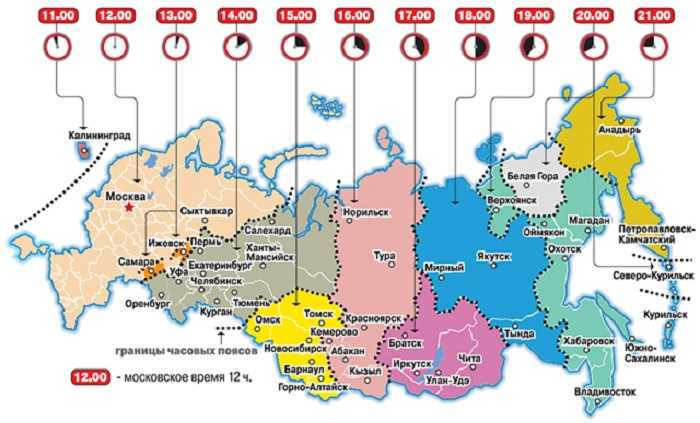
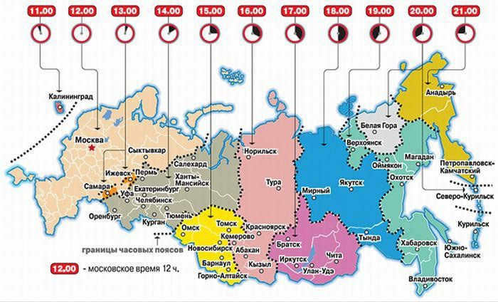
As of 2014, Russia officially recognizes 11 time zones, and each time zone is associated with a list of regions that fall within its boundaries.
Geographic atlases should include markings for time zones in order to allow for easy visual determination of the time in a specific location on Earth. There are several methods for indicating time zones:
- Using numbers 0 to 23 in an eastward direction starting from the zero (Greenwich) meridian.
- Using numbers 1 to 12 with a plus sign (+) for eastern time zones and numbers 1 to 12 with a minus sign (-) for western time zones.
- Using capital letters of the Latin alphabet: the letter Z for the zero time zone (Greenwich time), the letters A – M (excluding J) for eastern time zones, and the letters N – Y for western time zones.
Hence, to synchronize timekeeping worldwide and within individual countries, the concept of standard time was implemented. Standard time is determined in relation to the prime meridian, known as Greenwich Mean Time (GMT), and a unified system of time zone designations was also established for geographical atlases.
The eighth-grade geography lessons provide an introduction to time zones, as well as the concepts of local and zonal time. This article will explore the definition of zone time, its introduction, and the significance of time zones.
Background of the past
During the middle of the 19th century, the United Kingdom implemented the concept of belt time. This marked the first instance of establishing a standardized time across the entire country.
The necessity for implementing a singular time system arose from the rapid expansion of railway transportation. Scheduling trains became impractical when relying on the varying local times of different cities and regions.
In 1884, during the International Meridian Conference, the prime meridian was established at Greenwich. One of the resolutions proposed the adoption of time zones based on the latitude of each respective region.
The planet Earth undergoes rotation at a velocity of 15 degrees per hour. Consequently, the globe is partitioned into sectors of 15 degrees, each representing a distinct time zone with a one-hour difference. These sectors are commonly referred to as time zones.
Let’s establish the concept of zone time: it refers to an internationally recognized time standard that is established based on the division of the Earth’s surface into 15-degree time zones.
The initial time zone, known as Greenwich Mean Time (GMT), serves as the reference point. As one moves towards the east, each time zone is associated with an additional hour. Conversely, when traveling towards the west, one hour is subtracted from each time zone.
Russian Time Zones
Since 2011, Russia has replaced the term “zone time” with the term “local time”. Local time corresponds to a time zone, but many time zone boundaries are defined based on the administrative boundaries of the constituent entities of the Russian Federation.
The Republic of Sakha (Yakutia) is the only region in Russia with three time zones. Yakutia is the largest region in the world and also the coldest inhabited region.
There have been numerous changes to the boundaries of the country’s time zones over the years. The most recent alteration occurred in 2018. Presently, Russia is divided into 11 time zones, with 3 of them being restricted areas located near the southern border. When it is midnight in the capital city, it is 23 hours in Kaliningrad and 9 hours in Chukotka.
In order to accurately determine the local time, it is essential to consult the most up-to-date map of the country’s time zones. By doing so, any potential errors can be avoided.
What is the main takeaway from this?
We have acquired knowledge about the concept of belt time, its origins, and the initial implementation. We have become familiar with the time zones of Russia and discovered that utilizing a time zone map is the most effective way to determine local time.
- Zone time refers to the time in a specific time zone. This term has two meanings – geographical and administrative:
Belt time is the local mean solar time at the central meridian of a geographical time zone (also known as the mean solar time of the central meridian of the time zone). It is equivalent to the concept of nautical standard time in the English language. This time corresponds to the average noon falling within the interval of 11:30-12:30 on the earth’s surface within a specific geographic time zone.
Related concepts
Daylight Saving Time is a system where clocks are adjusted in the spring to be 1 hour ahead of the standard time during the winter period. This is done to make better use of daylight during the summer months. In the fall, the clocks are set back to standard time, which is often referred to as “winter” time in countries that observe daylight saving time. In most countries, the clock adjustment takes place on Saturday night.
Decree time was a time calculation system implemented in the USSR from 1930-1931. It involved adding one hour to the standard time in the country. Contrary to popular belief, this system was not established through a single decree, but rather through three government decrees.
Noon is the moment in the middle of the day, between sunrise and sunset. It is when the sun reaches its highest point in the sky, also known as solar noon.
Universal Time, also known as UT, is a time measurement system that is based on the Earth’s rotation. It serves as the contemporary alternative to Greenwich Mean Time (GMT), which is often mistakenly used interchangeably with Coordinated Universal Time (UTC). Universal Time was officially established on January 1, 1925. The term “world time” can be ambiguous, as there are multiple variations of it, with the primary ones being UT1 and UTC (refer to the information below for more details).
Federal Law No. 107-FZ of June 3, 2011 “On the Calculation of Time” is a legislation in Russia that outlines the legal framework for time calculation, time zone establishment, and the management of information related to accurate time and calendar dates. This law specifically eliminates the practice of adjusting clocks for daylight saving time.
In addition, astrologers consider other aspects related to the measurement of time. Specifically, they take into account the local average solar time of the main geographical meridian of the time zone in which a particular location is situated. This is known as zone time. To simplify timekeeping, the planet’s surface was divided into 24 meridians, each spanning 15 degrees of longitude. The zero meridian, known as the Greenwich meridian, serves as the reference point. As a result, there are 24 time zones, with each settlement within a time zone sharing the same time. Similarly, date change lines were established. These lines are imaginary and serve as a reference point for determining the calendar date. To the west of the date change line, the calendar date is one day ahead compared to countries in time zones located to the east.
In 1930, a special decree was issued in the USSR to move the clock hands one hour forward compared to the zone time. This was done to ensure that the working day started earlier and most of it was spent in natural light instead of artificial light. As a result, the time difference between Moscow and London is now three hours instead of two hours.
Zone time is determined by 24 main geographical meridians that are 15 degrees apart in longitude. Theoretically, each time zone should have the same time. However, for the sake of convenience, the time of the capital’s time zone is adopted for the entire country, even if it covers 2-3 time zones. In countries with large territories like Russia or the United States, there are multiple time zones. Russia has ten time zones, while the USA has five.
In 1930, our country implemented a decree by the Council of People’s Commissars to advance the time zone by 1 hour. The purpose of this was to maximize daylight utilization during the working day and conserve electricity. This adjustment became known as the decree time. To simplify timekeeping and prevent confusion due to numerous time zones, all transportation and communication systems operate based on Moscow Decree time. Every day, radio broadcasts inform about the various time zones across our country.
Europe’s railroads feature a diverse range of train types. Among them are the ICE, or intercity express, which is known for its speed and efficiency. The EU, or eurocity, is an international express train that connects different countries. The 1C, or intercity, is a common domestic express train that is widely used. The EN, or euronight, is a night express train that operates during nighttime hours. The D is a traditional fast train, while the E, or eiltsug, is a semi-accelerated train that offers a slightly slower pace. The ER, or Euroregional, is an international local train that serves regional areas. The SPR is a sprinter train, while the R is a regional train that operates locally. The RE, or regional express, is another type of regional train, while the RB, or regionalbahn, is an ordinary local train. Lastly, the S, or schnellbahn, is an intracity and short-distance suburban train that is part of the same transportation system as the metro trains. In Russia, the train types are not as varied, making it difficult to explain the nuances of their differences. Unlike European countries, Russia spans multiple time zones, so transportation schedules do not include zone time. However, if a train, ferry, or bus crosses a border and enters a new time zone, the new time is specified in the timetable.
Eastern European Time (EET) is a designation for the UTC+2 time zone. It is utilized by various European, North African, and Middle Eastern countries. Many of these countries also observe Eastern European Summer Time (EEST) during the summer months, which is UTC+3.
The zero meridian is a geographic meridian that serves as the reference point for measuring geographic longitude. In this system, the longitude of the zero meridian is defined as zero degrees.
Samara time (SAMT) is an unofficial term used to refer to the local time in the time zone where the city of Samara, the administrative center of Samara region, is located.
The longitude of the day refers to the time period between sunrise and sunset, during which at least part of the sun is visible above the horizon.
Civil time is a system of timekeeping based on the average solar day, with the day beginning at local midnight.
Moscow time (MSK, MSK) is the time zone used in the capital city of the Russian Federation, Moscow. It is defined by the Federal Law “On the Calculation of Time” and is observed in most regions of European Russia. As of October 26, 2014, Moscow time is UTC+3, while from March 27, 2011, to October 25, 2014, it was UTC+4.
Greenwich Mean Time (GMT) or Greenwich Mean Time is the average solar time along the meridian passing through the former location of the Greenwich Royal Observatory near London.
Europe spans across 7 primary time zones (ranging from UTC-01:00 to UTC+05:00), excluding Daylight Saving Time (four of these time zones are visible on the accompanying map, while one is situated to the west and does not fit within the map’s boundaries; this time zone is utilized in the Azores, as well as in regions like Georgia, Azerbaijan, the European segment of Russia, and Kazakhstan). The majority of European nations observe Daylight Saving Time. To learn more about Summer Time in Europe, refer to GMT.
The date line is a standard line on the Earth’s surface that stretches from the North Pole to the South Pole. On either side of this line, the local time differs by roughly a day. This means that the clocks on each side of the line will show a similar time of day, with a potential difference of one to three hours due to time zone variations. However, on the western side of the line, the date will be one day ahead compared to the eastern side. In other words, when the date changes at a specific moment on the date line.
The International Meridian Conference took place in October 1884 in Washington, DC. The main objective of this conference was to discuss and potentially select a meridian that would serve as a universal zero point for measuring longitude and a standard for timekeeping worldwide. As implied by the title of the conference proceedings, the goal was to establish the primary (zero) meridian and the universal twenty-four-hour system.
Central European Time (abbreviated CET) is one of the designations for the UTC+1 time zone. It is utilized by various countries in Europe and North Africa. Many of these countries also observe Central European Summer Time (CEST), which follows UTC+2, during daylight saving time.
A year is a unit of time measurement that is not consistent across different cultures. It traditionally represents one complete cycle of the changing seasons – spring, summer, fall, winter. In most countries, a year is defined as either 365 or 366 days on the calendar. However, the concept of a year has also been extended to describe the time it takes for a planet to orbit around a star in a planetary system. For example, the Earth completes one orbit around the Sun in a year.
Cartography, the field of study that focuses on analyzing, modeling, and visually representing the spatial arrangement, combination, and interrelationship of objects and phenomena in nature and society, has always been an integral aspect of human existence and history. Throughout the ages, individuals have utilized various forms of cartographic tools to aid in determining their whereabouts and facilitating their journeys across the globe, starting from primitive cave paintings, ancient Babylonian maps, and Greek and Asian cartographic works, all the way to the Age of Great Discovery and the present day. Some argue that maps not only serve as practical navigational aids, but also offer valuable insights into the cultural, historical, and geopolitical aspects of different regions.
Western European Time (WET) is a term used to refer to the time zone that corresponds to the zero meridian. This time zone encompasses parts of western and northwestern Europe.
Vladivostok Time (VLAT) is an informal designation for the local time observed in the time zone where the city of Vladivostok, the administrative capital of Primorsky Krai, is situated.
The territorial division of Antarctica is a geographical system used to divide the surface of the sixth continent of the Earth into territories known as “Lands” and “Shores”. This division is not based on political boundaries and has been established over the course of the 19th and 20th centuries.
The Maya Calendar, developed by the ancient Mesoamerican civilization of the Maya, is a complex system of calendars. It was utilized not only by the Maya, but also by other Central American peoples such as the Aztecs and Toltecs.
Secunda, denoted as “с” in Russian and “s” internationally, is a unit of time measurement. It is one of the fundamental units in the International System of Units (SI) and the GHS system. The secunda is also utilized as a basic unit of time in various other systems including ISS, ISSA, ICCA, ICCC, ICCG, ICCL, MSC, MSS, ICGS, and MTS.
The modern measurement of time is based on the Earth’s rotation and revolution around the Sun, as well as the Moon’s revolution around the Earth. This choice of units is influenced by both historical and practical considerations, as it allows for the coordination of people’s activities with the natural cycles of day and night, as well as the changing seasons.
Japanese traditional clocks, known as wadokei, are unique timekeeping devices that originated in Japan. They utilize special values to indicate the passage of time.
The Queensland Daylight Saving Time Referendum of 1992 was a vote held in Queensland to determine whether or not to implement daylight saving time.
Meteorology (from the Greek word μετεωρο-λογία, meaning “study of celestial phenomena”, derived from the Greek word μετ-έωρα, meaning “celestial phenomena” (specifically, “atmospheric and celestial phenomena”, “celestial”) + the Greek word λογία, meaning “science”) is a scientific and applied field of knowledge that focuses on the structure and properties of the Earth’s atmosphere, as well as the physical and chemical processes that occur within it.
Pā (derived from the Maori term pā) is a word commonly used to describe villages and townships in Maori culture. However, it is most often associated with fortified hills that have specially constructed terraces for defensive purposes. In general, the term pā can refer to any type of fortification.
POLYMODE was an oceanographic experiment conducted by both Soviet and American scientists in the Bermuda area.
Meter (Russian: m; international: m; from the Greek μέτρον “measure, measurer”) is a fundamental length unit in the International System of Units (SI), one of the seven fundamental SI units. It is also a basic length unit in the ISS, ISSA, ICCA, ICCC, ICCG, ICCL, MSS, ICCS, and MTS systems. Additionally, in all of these systems, the meter is used as the unit for measuring rolling friction coefficient, radiation wavelength, free path length, optical path length, focal length, and Compton’s.
Zytglogge, also known as the Clock Tower (German: Zytglogge), is a medieval clock tower located in the historical area of Bern.
Heartland refers to the vast northeastern region of Eurasia, which is surrounded by mountain ranges to the south and east. The exact boundaries of this region may vary depending on the researcher. The term was introduced by Halford J. Mackinder, a British geographer and professor at Oxford University, in a report to the Royal Geographical Society on January 25, 1904, and later published. It serves as a key concept in geopolitical studies.
The Inca Empire, located in the Andean region of South America, had its own unique system of mathematics. The inhabitants of this empire believed in the power of numbers and used various tools for counting and calculations. One such tool was the yupana, a counting device that came in multiple variations. Additionally, the Inca people used a system called kipu for storage, reproduction, and statistical collection of information. Similar to the binary system with 128 variations, kipu contained large volumes of numerical data and was considered equivalent to a notarial act in Europe. The kipu was carefully preserved and stored in vaults.
The Antikytherian Mechanism, also spelled as antikytherian, andikitherian, antikypherian, or Μηχανισμός των Αντικυθήρων, is an ancient mechanical device that was recovered in 1901 from a sunken ship. The wreckage of the ship and its contents were found by a Greek diver on April 4, 1900 near the Greek island of Antikythera (Αντικύθηρα). The precise date of the mechanism is believed to be around 100 BC (possibly even earlier, around 150 BC or 205 BC). Today, it is housed in the National Archaeological Museum in Athens.
Rules of the Road refer to a set of regulations that govern the responsibilities and obligations of all road users, including vehicle drivers, passengers, pedestrians, and others. These rules also include technical specifications for vehicles in order to ensure road safety.
Moresnet (Mornet) or Neutral Moresnet (Neutral Mornet) (Dutch: Neutraal Moresnet, German: Neutral-Moresnet, French: Moresnet-Neutre) is a neutral territory, a shared zone with an approximate area of 3.5 square kilometers, that existed between 1816 and 1920. Situated 7 kilometers southwest of Aachen, south of Walserberg, it now marks the point where the borders of Germany, Belgium, and the Netherlands intersect.
Ideas similar to those underlying the metric system were explored in the 16th and 17th centuries. Simon Stevin put forth proposals for decimal notation, and John Wilkins presented a preliminary version of a decimal system of measurements based on natural units. The first practical application of the metric system took place in 1799, during the French Revolution, when the existing measurement system, which had gained a negative reputation, was temporarily replaced by a decimal system founded on natural units.
The Astrarium, also known as the Planetarium, is a historical astronomical device designed in the 14th century by Giovanni de Dondi from Italy. The creation of this instrument signified a significant advancement in European technology pertaining to the production of mechanical timekeeping devices. The Astrarium served as a model of the solar system and, in addition to measuring time and displaying calendar dates and holidays, it demonstrated the movement of planets across the celestial sphere. This was its primary function, distinguishing it from other astronomical clocks.
The traditional name for a globe created under the direction of Martin Beheim in Nuremberg is “Earth Apple” (German: Erdapfel). According to the inscription at the south pole, the globe was made in 1492 on the order of the city council. However, existing documents indicate that it was actually physically created between 1493 and 1494, with the city council only paying for its creation in 1494. This particular globe is the oldest surviving globe in existence.
North Atlantic Tracks, also known as NAT Tracks, are established air routes over the Atlantic Ocean that connect North America with Europe. These tracks are designed to provide the necessary guidance in areas over the ocean where continuous radar support for flights is challenging.
The Line of Current Control (LCC) is the boundary that separates India and the People’s Republic of China (PRC). Stretching for a length of 4,057 kilometers, it extends across three northern states of India: Ladakh and Kashmir in the west, Uttarakhand and Himachal in the middle, and Sikkim and Arunachal in the east. The term “Line of Current Control” was initially coined by Chinese Prime Minister Zhou Enlai in a letter to Indian Prime Minister Nehru on October 24, 1959.
A boundary marker, known as a hito fronterizo (derived from the Latin word fictus), is a durable sign that is typically constructed from stone (although alternative materials are now utilized) and is utilized to delineate the boundaries between private properties or territories. In certain instances, these markers are also employed to indicate the elevation or distance of a road or trail, in which case they are referred to as geographical markers. In Spain, the terms “mojón,” “coto,” and “cipo” are commonly used to denote these markers. Dividing markers have historically been utilized to identify significant locations along various routes.
The winter solstice is a celestial event that occurs when the Earth’s axis tilts away from the Sun to its maximum degree. During the solstice, the Earth’s axis is inclined 23° 26′ relative to the Sun. This phenomenon is most noticeable for people living in high latitudes, as it marks the shortest day and the longest night of the year, with the lowest point of the Sun’s ascent in the sky.
An Inuksuk (plural: Inuksuit; also commonly spelled Inukshuk) is a stone structure in Inuit culture. The word “Inuksuk” is derived from the Inuktitut language and means “in the likeness of a person.”
The Inca Calendar was a calendar system developed by the Inca civilization in the pre-Columbian era. It included both solar and lunar astronomical calendars.


