
During a scorching summer day, when the sky is clear and we are drained from the extreme heat, we frequently hear the phrase “the sun is at its zenith”. In our interpretation, it signifies that the celestial body is at its peak position and intensely heats up, almost as if burning the earth. Let’s venture into the realm of astronomy and delve deeper into the meaning behind this expression and assess the accuracy of our understanding.

Parallels on Earth
From our time in school, we are aware of the existence of parallels on our planet, which are invisible lines. These lines are a result of basic principles of geometry and physics, and understanding their significance is crucial in comprehending the field of geography. There are three key lines that are commonly recognized – the equator, the Arctic Circle, and the tropics.
The Equator
The equator is commonly referred to as an imperceptible (conventional) border that separates our planet into two identical halves – the Southern and Northern hemispheres. It has been widely acknowledged that the Earth is not supported by three whales, as was once believed in ancient times, but instead has a spherical shape and, in addition to orbiting the Sun, rotates on its axis. Consequently, the equator emerges as the longest parallel on Earth, spanning approximately 40 thousand kilometers. From a mathematical standpoint, this is quite clear, but does it hold any significance in the field of geography? Upon closer examination, it becomes evident that the region between the tropics receives the most solar heat and light. This is due to the fact that this particular area of the Earth remains constantly facing the Sun, resulting in nearly vertical rays. Consequently, the equatorial regions experience the highest air temperatures, with moisture-laden air masses leading to significant evaporation. Twice a year, the sun reaches its zenith at the equator, shining directly downward. This phenomenon, for instance, never occurs in Russia.

Tropics
There are Southern and Northern tropics located on the Earth. It is important to note that the sun reaches its highest point in the sky only once a year, which happens on the solstice. On December 22, during the winter solstice, the Southern Hemisphere is facing the Sun to the maximum extent, while on June 22, it is the opposite.
Occasionally, the Southern and Northern tropics are referred to by the name of the zodiacal constellation that lies along the Sun’s path during these periods. Thus, the Southern Tropic is commonly known as the Tropic of Capricorn, and the Northern Tropic is called the Tropic of Cancer, marking December and June respectively.
Polar Circles
The polar circle is the latitude at which the polar night or day can be observed. The positioning of the polar circles is also mathematically explained as 90° minus the tilt of the Earth’s axis. For Earth, the value of the polar circles is 66.5°. Unfortunately, individuals residing in temperate latitudes are unable to witness these phenomena. However, it is completely natural for the sun to be at its zenith on the parallel that corresponds to the polar circle.

Facts that are widely known
The Earth is in constant motion and not only orbits around the Sun, but also rotates on its axis once every 24 hours. Throughout the year, we can observe changes in the length of the day, the temperature outside, and for the most observant, the shifting positions of the stars in the sky. It takes the Earth 364 days to complete a full orbit around the Sun.
Day and night
When darkness, also known as night, falls, it signifies that the Sun is illuminating the other hemisphere during a particular period of time. An interesting question arises as to why the duration of the day is not equal to the length of the night. The answer lies in the fact that the plane of the Sun’s trajectory is not perpendicular to the Earth’s axis. If it were, we would not experience the changing seasons, where the ratio of daylight to darkness varies.
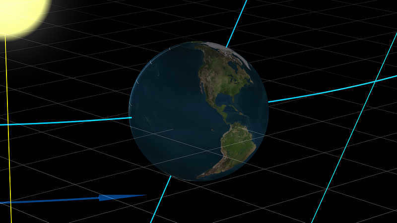
On the 20th of March, the North Pole tips towards the Sun. Then, around noon on the equator, we can confidently declare that the sun is directly overhead. This phenomenon repeats itself at more northerly locations in the following days. By June 22nd, the sun is directly overhead on the Tropic of Cancer, marking the midpoint of summer and its longest days in the northern hemisphere. This event is commonly known as the solstice.
Interestingly, everything then happens in reverse order, until September 23rd when, once again, the sun is directly overhead at noon on the equator – this marks the arrival of midsummer in the southern hemisphere.
It can be inferred from all of this information that when the sun reaches its highest point at the equator, the night is 12 hours long all over the globe, which is the same duration as the day. This occurrence is commonly referred to as the autumn or vernal equinox.
Even though we have already explained the concept of “the sun at the zenith” accurately, we are more accustomed to using a different wording that simply means the sun is at its highest point on that specific day.
On December 22, when the sun is at its zenith on the Southern Tropic.

The sun reaches its highest point in the sky on December 22nd (the winter solstice) at the southern tropic.
Conversely, on the day of the summer solstice, the sun is at its zenith at the northern tropic.
In December, the polar day occurs at the southern polar circle.
If I am not mistaken, this also happens on the day of the winter solstice.
On the contrary, in the north polar circle, the opposite is true.

Could you kindly provide the answer?
During December 22nd, where is the Sun positioned at its highest point? Please choose one of the following options: 1) Southern Tropic 2) Northern Tropic 3) Equator 4) Arctic Circle.

Which of the following statements is correct regarding the Sun’s position above the horizon at various latitudes?
Which of the following statements accurately describes the Sun’s position above the horizon at different latitudes?
A) At the equator, the Sun is always at an altitude of 90 degrees at noon.
B) The Sun is at its zenith twice a year above the Northern Tropic.
C) At the equator, the Sun is at its zenith during the equinoxes.
D) The Sun is at its zenith during the equinoxes above the Southern Tropic.
a) Days when the sun is directly overhead the Tropic of Cancer.
b) Days when the sun is directly overhead the Tropic of Capricorn.
c) Days when the sun is directly overhead the Equator?

On which parallel does the Sun reach its zenith?
On which parallel does the Sun reach its zenith?
A) North Pole B) Southern Tropic C) Northern Tropic D) Equator.
I believe the correct answer is 1, please correct me if I am mistaken. Which statement accurately describes the geographical aspects of the Earth’s light?
I believe the correct answer is 1, please correct me if I am wrong.
Which statement accurately describes the geographical aspects of Earth’s illumination?
1) Within the South Polar Circle, June 23 experiences polar night. 2) On September 23, the Northern Hemisphere is more illuminated than the Southern Hemisphere.
3) On December 22, the noon Sun is directly overhead at the equator.
4) On March 21, the noon Sun is directly overhead at the Northern Tropic.


Where is the sun directly above (at its highest point) at midday on December 22?
Where is the Sun directly above (at its highest point) at midday on December 22?

What is the term for the day when the Sun is directly above the southern tropic?
What is the name given to the day when the Sun is directly above the southern tropic?
What does it mean when the sun is directly overhead at the Southern Tropic?
When the sun is directly overhead at the Southern Tropic, it is at its zenith.
Where is the sun at its highest point on December 22: a) the equator ; b) the southern tropic ; c) the northern tropic ; d) the southern polar circle?
On December 22, the sun reaches its zenith over the following locations: a) equator ; b) southern tropic ; c) northern tropic ; d) southern polar circle.
How many times a year does the sun reach its highest point in places located between the Northern and Southern Tropics?
This page provides the answer to the query: When is the sun at its highest point on the Southern Tropic, specifically on December 22? This question falls under the field of Geography and is relevant for students in grades 1 – 4. If you are looking for similar queries and answers in the Geography category, you can utilize the “smart search” feature. By using relevant keywords, you can find answers that closely match your search criteria. The interface is user-friendly and allows you to rephrase your question if needed. Additionally, you can also browse the answers and comments provided by other users.
This region is divided into four climatic belts that stretch along the latitudes. The northern Indian Ocean experiences a monsoon climate, with frequent cyclones moving towards the coast due to the influence of the Asian continent.
The African continent is home to three major racial groups, with the Negroid being the most prevalent. It is particularly prominent in former European colonies such as South Africa.
It is not very difficult, here is the solution.

The Nelson River is a Canadian river that stretches for 640 kilometers. It originates from Lake Winnipeg and flows into Hudson Bay, serving as a drainage system for the Bow-Saskatchewan-Nelson lake-river system. The basin area covers a vast expanse of 1072 thousand km2. The river is known for its rapids, and at its mouth, the average water flow measures 23.

There is P. S It is possible to find it on the web))).

Indications of stable and cloudless weather: – in clear weather, the temperature drops gradually, the atmospheric pressure rises slowly, irregular cumulus clouds form, and there is a northeasterly or easterly wind;
14 A 15 B 16 A 17 C 18 B 19 D 20 B 21 Alice 22 Brummie 23 Hawaii 24 dog 25 COP.
© 2000-2023. It is mandatory to provide a reference when using the materials, either in full or in part. You must be 16 years or older to access the content.
The website is secured by reCAPTCHA technology, which is subject to Google’s Privacy Policy and Terms of Use.
What causes the change in temperature between winter and summer? Surprisingly, many individuals, even those who are intelligent and educated, do not possess the answer to this inquiry. It is due to the Earth’s orbit around the Sun – that’s for sure, but why exactly? The most common – and incorrect – response is: because the Earth is further away from the Sun in winter than in summer. However, this explanation does not hold true: because in the southern hemisphere, the seasons are reversed, with hot weather in January and cold weather in July! In reality, the Earth does not follow a perfectly circular orbit around the Sun, but rather the opposite: during our summer, the Earth is actually further from the Sun, and during our winter, it is closer!
Incidentally, the presence of summer and winter is not universal. Moreover, even in places where they do occur, they manifest in unique ways. This suggests that our position in relation to the Sun is not the sole determinant of seasonal change; the manner in which we rotate on our own axis also plays a significant role. In order to fully comprehend these phenomena, let us embark on a journey to various planets before returning to Earth.
As always, it is more beneficial to solve a problem on your own rather than relying on someone else’s solution, so it is important to try and comprehend each problem independently. In the event that you are unable to do so, we are here to assist you. To conduct this experiment, you will require a ball (or preferably a globe) and a table lamp (ideally without a shade). Begin by drawing the poles and the equator on the ball, creating a large circle in the middle between the poles. This will represent the planet, while the lamp will symbolize the Sun. If a lamp is unavailable, you can substitute it with your own head: the part of the planet that you can see will be illuminated by the sun, indicating daytime, while the part that is not visible will signify nighttime. Another option is to form a ball out of plasticine with two handles, which will serve as a local inhabitant. The fictional beings that reside on other planets (except for Earth) will be referred to as little people. The period of time it takes for a planet to complete one orbit around the Sun (which varies for each planet) will be referred to as the local year, while the time it takes for a planet to rotate on its axis will be referred to as days.
This planet has a rotation axis that is almost perfectly perpendicular to the plane in which it orbits the Sun. In other words, if you imagine the Sun lying on a table and Jupiter crawling around it on the table, one of Jupiter’s poles is always pointing directly upward – let’s call it the north pole. And Jupiter doesn’t just crawl, it rapidly spins around its vertical axis (Fig. 1). Just to clarify, all planets move counterclockwise around the Sun (when viewed from Polaris) and almost all rotate in the same direction around their axes.
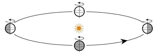
Figure 1. Jupiter orbits the Sun in a circular path and rotates quickly on its axis. The diagram shows Jupiter’s positions during each quarter of its year, representing winter, spring, and so on. The darker areas indicate nighttime on the planet, while the brighter areas are illuminated by the Sun, indicating daytime.
Get started exercise. Locate a spot on your Jupiter where the Sun is currently at its highest point, directly above your head. Then, identify all the locations where the Sun is on the horizon (hint: these points form a large circle on the planet’s surface). Can you determine where the Sun is rising and setting on Jupiter? Compare your findings with Figure 2 on the following page. Imagine placing a person at a latitude of approximately 45° (midway between the north pole and the equator), instruct them to raise one hand and extend their other arm towards the north. Rotate the planet (without changing its tilt!) until the Sun is at its highest point above the horizon for this individual – this signifies noon. Now, which direction is the Sun located relative to this person – south, north, or east? Furthermore, what would an individual living in the southern hemisphere say about the Sun’s position?
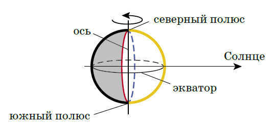
Fig. 2. The red line indicates the current locations of sunrise, the blue line indicates the current locations of sunset, and the yellow line represents the current locations of noon.
Problem Y1. Consider an extraterrestrial being residing on the equator of Jupiter. Analyze the path of the Sun across the celestial dome throughout the day from its vantage point. Determine the precise location where the Sun rises and sets in its world. Additionally, identify the specific position in the sky where this creature observes the Sun at its zenith during noon. Assuming this creature shares the same belief as ancient civilizations, picturing the sky as a solid sphere with celestial bodies in motion, how would it depict the Sun’s trajectory on this celestial surface?
Now, envision a scenario where Jupiter completes a quarter of its orbital revolution around the Sun. Does this have any impact on the aforementioned aspects for our extraterrestrial observer?
Problem J2. Address the same inquiries as presented in Problem J1, but this time for a diminutive being residing at the North Pole.
Problem J3. Determine the locations of the tropical and polar zones on Jupiter.
And lastly, the final challenge regarding Jupiter.
Task Y4. Attempt to ascertain the lifestyle of an individual situated at a latitude of 45 °, which is halfway between the equator and the pole. Where does the Sun rise on the horizon for this person? How does it continue to move? What is the maximum height it reaches?
Jupiter Troubleshooting Solutions
It is important to note that the topic of seasons is not relevant when discussing problems about Jupiter. This is because Jupiter does not experience seasons like Earth does. Unlike Earth, Jupiter’s residents experience the same conditions every day as the planet orbits the sun.
(Ю1) On Jupiter, if a person were to live on the equator, they would observe the Sun rising directly in the east. This can be confirmed by extending one arm to the north and the other arm to the east. As the day progresses, the Sun continues to rise until it reaches its highest point at noon, directly overhead. The Sun then follows the same circular path and sets strictly in the west after another quarter of a day. Nighttime on Jupiter lasts exactly half a day. This pattern remains consistent throughout the entire year!
(Ю2) Life for a man at the North Pole is even more monotonous. The sun is constantly on the horizon! There is no dawn or dusk, only eternal polar twilight. However, the Sun does not remain stationary – it moves in a large circle, always staying on the horizon. This can be confirmed by extending the little man’s arm in any direction and rotating the planet around its axis.
(Ю3) As we have already observed, at the equator, the Sun reaches its highest point in the sky (the zenith) every day. This phenomenon is exclusive to those living at the equator: the further north one resides, the lower the Sun’s height at noon becomes (resulting in less heat reaching the planet’s surface). Refer to Figure 3 for visual representation.
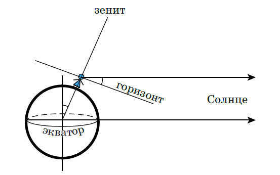
Figure 3. The size of any planet is much smaller than the distance between the planet and the Sun. Therefore, we can assume that the directions to the Sun from any point on the planet are parallel, as shown in this figure. The altitude of the Sun at noon is equal to the angular distance from the observer to the pole, which is 90 degrees minus the observer’s latitude: the angles labeled in the figure with arcs are equal to
Figure 4. The equator represents the tropical zone (marked by a red line), while the polar zones are represented by two dots (indicated by blue dots)
Thus, on this planet, the equator serves as the tropical zone. As for the polar zone, it is represented by two dots, indicating that the Sun never goes below the horizon at the poles (Fig. 4).
(Ю4) From the perspective of all “observers,” the Sun always rises directly in the east and sets in the west. Throughout the day, it follows a circular path, but the inclination of this path to the horizon plane becomes more pronounced as the latitude decreases (Fig. 5). For instance, if the latitude is 45 degrees, the Sun will rise above the horizon at 90 degrees minus 45 degrees, which equals 45 degrees. The Sun follows the same circular path every day throughout the year.
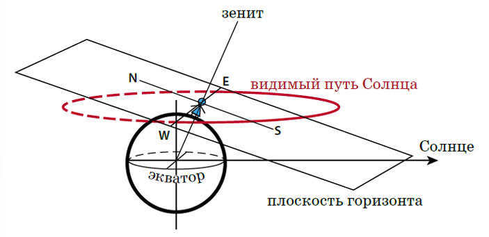
Figure 5. The Sun’s Daily Movement from a Human Perspective: The Sun appears above the horizon for half of the day and below it for the other half
We’ve covered Jupiter, now let’s explore another planet!
Uranus.
This celestial body “rolls on its side” – its rotational axis lies precisely in the plane of its orbit around the Sun (Fig. 6). It is of utmost significance that, akin to any properly coiled canine, planets never desire to alter the course of their rotation, and the axis of Uranus perpetually “gazes” in the same direction – at the identical faraway star! (Instead of incessantly turning towards the Sun, as one might assume.) Having already garnered some familiarity with Jupiter, let us embark on an exploration of this planet. Take note that now the circumstances for every inhabitant of the planet alter throughout the year! When solving quandaries, incorporate more illustrations, opt for a suitable perspective: occasionally, the aerial view serves better, while at other times, a lateral viewpoint is more apt.
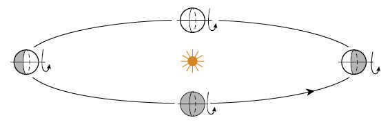
Figure 6: The illustration shows the path of Uranus as it orbits around the Sun. The planet’s axis always points in the same direction.
Task U1: Locate and illustrate the polar and tropical zones of Uranus. It is important to note that the specified condition must occur at least once a year.
Problem 2. Let’s explore the behavior of the pole dweller’s luminosity throughout the year. Determine when it experiences summer and winter in its orbit. Are there any days when the Sun is directly overhead, and if so, how many of these occur in a year? Additionally, does the pole dweller experience polar day and polar night, and if they do, what is the duration of each phenomenon during the year? Use color to highlight the corresponding points and regions on the planet’s orbit (from a top view or top-side view).
Task U3. Apply the same inquiries to an equator resident.
Problem 4. Investigate the same set of questions for a resident of the “Venice of Venice” at a latitude of 45°.
Task U5. Please illustrate the apparent path of the Sun in the sky throughout the year for each of the heroes from tasks U2-U4. It is worth noting that for the inhabitant of Jupiter, the Sun follows the same circular path all year round. How about here on Earth? Hint: Is there a day when the Sun appears to be stationary?
| Earth | 1 year = 365.25 Earth days | 24 Earth hours |
| Jupiter | 12 Earth years | 10 Earth hours |
| Uranus | 84 Earth years | 17 Earth hours |
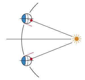
Figure 7. A bird’s eye view of Uranus’ orbit (please note that the planet’s size is exaggerated!). The red dot indicates the position of the Sun at its highest point, while the shaded area represents the region where the Sun does not rise (known as the polar night). The red ray illustrates the location where the Sun can only be seen on the horizon. Interestingly, the red dot marks the same spot! The positions of the planet are depicted at intervals of approximately 1/6th of an Uranian year and every half a day.
(U1) It is worth remembering that the tropics are the areas where the Sun reaches its zenith. In the case of Uranus, this occurs twice a year all over the planet, while at the poles it only happens once a year (refer to Fig. 7).
Therefore, the tropical region can be found in every part of the world, and its limits, known as the tropics, extend to the polar areas. The polar zones are also present everywhere, as during certain periods when the Earth’s axis is directly facing the Sun (as illustrated in Figure 8), one half of the planet experiences polar day while the other half experiences polar night. However, at the equator of Uranus during these periods, there is only polar twilight, with the Sun positioned on the horizon. Consequently, there is no actual polar day or night at the equator.
(U2) At the North Pole, the period of continuous daylight, known as the polar day, lasts for six months. During this time, the Sun remains above the horizon and moves in a circular path at nearly the same height throughout the day. If Uranus were located closer to the Sun, the temperatures at the North Pole during the polar day would be extremely hot, with the Sun reaching its highest point directly overhead. Conversely, while it is polar day at the North Pole, the South Pole experiences polar night, where the Sun remains below the horizon for six months (Figure 8 illustrates the contrast between “summer” and “winter”). Following the brief period of polar twilight, the polar night begins and lasts for another six months.
(U3) For those living on the equator, the moment when the Sun is directly overhead coincides with twilight at the poles (the top and bottom points of the planet in the illustration). However, at midnight, the Sun is positioned exactly “beneath your feet”. And after three months (shown on the left and right sides of the illustration), it stays on the horizon all day long – but it doesn’t move in a circular path like it would at the pole of Jupiter, instead remaining stationary! You can verify this with a “human”. Throughout the rest of the day, day and night are of equal duration at the equator.
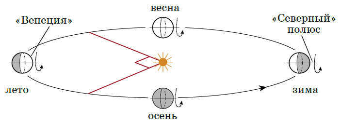
Figure 8. The movement of Uranus. The seasons occur in the right (“northern”) hemisphere.
(У4) In the “Venetians,” the days when the Sun is directly overhead occur every three months (these days correspond to the positions of the planet shown in Figure 8 by the red lines).
Due to the presence of long polar days and polar nights on almost the entire planet, Uranus experiences the most monotonous weather in the solar system. The temperature and pressure remain consistent throughout large areas of its atmosphere, resulting in no significant variations or strong winds.
This is in contrast to Neptune, which is located one and a half times farther from the Sun. While hurricanes and cyclones, which are of interest to astronomers, occur on Neptune, Uranus experiences them only during the spring and fall seasons, when the day-night cycle follows a more “normal” pattern.
(U5) It is interesting to note that the visible path of the Sun is consistent for all individuals across the globe, despite the fact that they view it from different angles. This is similar to the phenomenon observed on Jupiter, where the Sun’s movement along the great circle appears tilted to each observer in a unique manner. Let’s consider the perspective from the North Pole. During the solstice (depicted on the left in Figure 8), the Sun is directly overhead, or at the zenith. From there, it gradually descends in a spiral pattern, completing an almost horizontal revolution each day. The circles traced by the Sun become lower and wider as time progresses. After a quarter of a year, the next spiral is already visible on the horizon, and for the following half year, the spiral continues its descent “underground”. The Sun eventually reaches its lowest point, directly beneath your feet, before ascending back to the horizon and, ultimately, returning to the zenith.
At the equator, the Sun follows a similar path, but it is positioned horizontally. If a person living on the equator were to observe the Sun throughout the year while lying down with their head to the north, they would see the Sun both above and below the horizon, just like someone at the North Pole.
By understanding this, we can easily visualize the annual movement of the Sun at any latitude (Fig. 9).
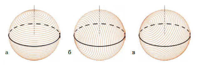
Figure 9: Sun’s visible trajectory during a six-month period: a – at Uranus’ pole, b – at the equator, c – at latitude 45°. The observer is positioned at the center of the sphere and observes it from the inside! The black circle represents the horizon line, while the vertical line indicates the direction towards the zenith. The image is created assuming there are 80 days in a year. The number of spiral turns matches the number of days in a half-year.
For now, we will temporarily move away from the solar system, as there is currently no planet within it that we require.
This fictional world lies between Jupiter and Uranus, serving as a celestial middleman. With an inclined axis of rotation at a 45-degree angle to the orbital plane (see Fig. 10), it stands as a unique anomaly in the cosmos.
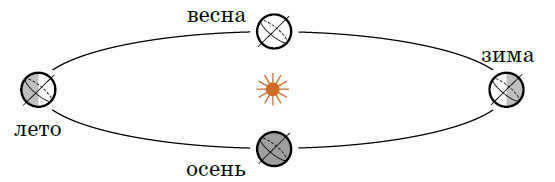
Figure 10. Planet Zeta. The northern hemisphere experiences different seasons.
Question D1. How do the polar and tropical zones appear on this planet?
Task D2. What is the movement of the Sun throughout the year for an observer at the pole? at the equator? at “Venice”? Does it reach its highest point, and if so, when? Does it go below the horizon every 24 hours, and if not, how long is the polar day?
Question D3. Draw the visible path of the Sun in the sky for each of these locations over the course of a year.
Solutions to issues regarding the planet Zeta
(D1) The tropical zone on Jupiter is limited to just the equator, while on Uranus it covers the entire planet. However, on planet Zeta, we find ourselves in an intermediate situation. The northernmost points where the Sun is directly overhead have a latitude of 45°, which is exactly halfway between the equator and the North Pole. Along this entire latitude line, the hottest day occurs when the planet’s axis is closest to aligning with the direction of the Sun (Fig. 11).
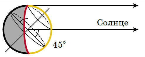
Figure 11. The red line indicates all the points where the sun is rising, and the yellow line indicates the locations where it is noon. The equator and the parallel at 45° north latitude are marked
Figure 12. The planet Zeta has distinct polar (shown in blue) and tropical (shown in red) regions.
On this day, the length of daylight is at its maximum: as depicted in the same image, the Sun reaches its zenith at noon and touches the horizon at midnight. If one were to move closer to the pole, the Sun would not set on this day, but it would also not rise to the zenith. The same situation occurs in the southern hemisphere six months later. Therefore, the polar regions are like “caps” around both poles, and the tropical regions are like a “belt” around the equator. The boundaries of both regions on Zeta coincide and are located at the parallels of 45° north and south latitude. These boundaries represent both the tropics and the polar circles (Figure 12).
Within the tropical region, the Sun reaches its highest point in the sky twice a year, while on the equator, this only occurs during the equinoxes. During the summer, those living on the equator observe the Sun in the north, while in the winter it appears in the south. On the equator, day and night are always of equal length, and the Sun rises and sets directly above the horizon. In the city of “Venice,” the Sun reaches its zenith only once a year, during the summer solstice. On this day, it does not set, but instead grazes the horizon. During the equinoxes, day and night are of equal duration, while for half of the year, the days are longer than the nights, and for the other half, they are shorter. Finally, on the day of the winter solstice, the Sun does not rise, resulting in the shortest day of the year and a polar night.
(D3) Similar to Uranus, the Sun’s visible yearly trajectory is spiral-shaped, but it varies for inhabitants in different locations on the planet due to their inclination. However, unlike Uranus, the spiral does not encompass the entire sphere. This can be easily confirmed by plotting the Sun’s trajectory at the pole: there, the axis of the spiral is vertical and the Sun never rises above 45°.
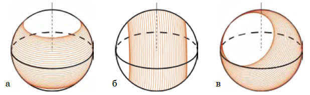
Figure 13. The Sun’s observable trajectory during a six-month period on the planet Dzeta: a – at the North pole, b – at the equator, c – at a latitude of 45°
Understanding the changing of seasons on Earth is now made easier. The Earth is quite similar to Zeta, with one key distinction: our planet’s axis deviates from the “vertical” at a lesser angle of only 23 degrees above the horizon. This means we are slightly closer to Jupiter than Zeta. As a result, our spiral shape is more flattened, with the outermost turns being 23 degrees away from its center. If our axis were to be “straightened” towards the vertical, the spiral would flatten into a circle resembling Jupiter’s. Consequently, at the poles, the Sun never rises more than 23 degrees above the horizon. By tilting the spiral, it becomes apparent that the tropical zone is also more flattened compared to Dzeta, with the latitude of the tropics again being 23 degrees. Similarly, the polar circles also deviate by 23 degrees from the poles. For instance, Moscow falls within the intermediate region between these two areas, experiencing neither polar nights nor the Sun at zenith.
Finally, we have some extra tasks for those who enjoy exploring different planets.
- What is the reason behind cold winters and warm summers?
- How high does the Sun rise on Zeta’s equator during the summer solstice? And what about the Earth’s equator?
The equinox is a significant event. During this time, day and night have equal duration all over the Earth – globally. However, the very next day, the length of either day or night starts to differ in various parts of the planet. The difference becomes more pronounced the farther away you go. Nevertheless, there are two major exceptions.
At the equator of a planet, the duration of day and night is always equal – regardless of the day in the calendar. At the poles, during the equinox, there is either polar day or polar night – until the next equinox arrives.
There are several traditional ways to distinguish between seasons.
According to the widely accepted calendar, autumn officially begins on September 1st. However, in astronomy, the start of the fall season is marked by the autumnal equinox. Until that day, astronomers still consider it to be summer. Nevertheless, most people prefer to determine the seasons based on weather conditions, which is a practical approach. Neither the calendar nor the stars can provide you with accurate advice on what to wear and whether to bring an umbrella when going outside. However, it is important to note that astronomical factors, such as the Earth’s position in its orbit around the Sun, are the primary reasons for the changing of seasons.
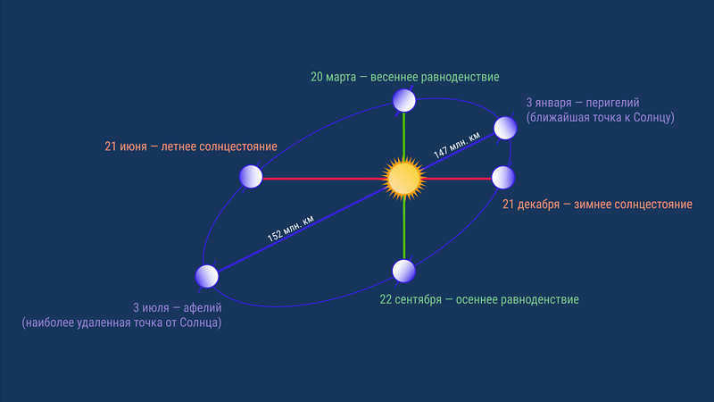
Despite the Earth revolving around the Sun in an elliptical orbit, the variation in the distance between the Earth and the Sun has minimal impact on the weather and is not responsible for the changing seasons. In reality, the distance between the Earth and the Sun only changes by a mere 3% throughout the year.
During July, the Earth and the Sun are approximately 152 million kilometers apart, whereas in January, they are about 147 million kilometers apart. It is important to note that we are actually closer to the Sun during winter. However, it should be mentioned that this pertains to the winter season in the northern hemisphere. Meanwhile, in the southern hemisphere, it is summer during this time.
Now, as we move closer to the Sun, we can feel the temperature dropping outside. How can we explain this?
The reason behind the change of seasons on our planet can be attributed to the tilt of its axis of rotation in relation to the Earth’s orbit.
I understand that the previous sentence may seem complicated. This is why schools often use a visual demonstration instead of a verbal explanation to showcase the phenomenon of seasonal change. One such demonstration involves the use of a simple device called a tellurium. Witnessing it firsthand is truly enlightening.
Tellurium serves as a representation of the Sun-Earth system, showcasing the Sun’s illumination of the Earth and the varying intensities of illumination across the Earth’s northern and southern hemispheres. As the device itself cannot be utilized while perusing this article, we will rely on visual depictions to aid our understanding. Hopefully, these illustrations will prove to be adequately informative.
To begin comprehending the dynamics at play, it is important to note that the Earth’s daily rotation axis points towards Polaris, situated in the constellation of Ursa Minor. Conversely, the axis of the Earth’s orbit is directed towards the head of the constellation Draco. The separation between these two directions amounts to 23.5 degrees.
Have a look
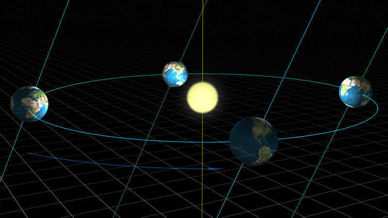
The Earth, as it orbits the Sun, keeps its axis of rotation aligned in space. Because of this tilt, our planet appears to expose either the northern hemisphere or the southern hemisphere to the sunlight throughout the year. At certain points in between, both hemispheres are evenly illuminated.
The incidence angle of the sun’s rays.
Rays that fall perpendicular to the surface of the Earth heat it more, while rays that fall at an angle have less ability to heat. This is not due to the properties of the rays or their unwillingness to transfer energy to surfaces at an angle, but rather to the number of these rays.
The term “rays” is a figurative expression.
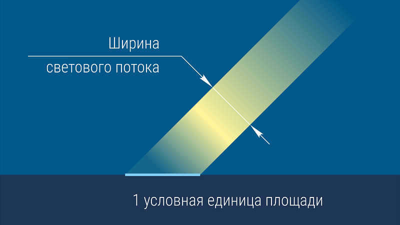
It is more accurate to refer to them as light flow. The wider the flow, the greater the amount of energy it contains.
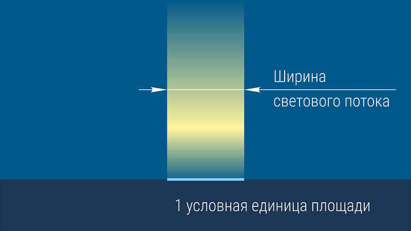
Let’s examine the amount of energy that is delivered to a unit area when the flux falls directly on it, and also at various angles. Assuming that the width of the flux falling directly on our reference area is 100%, if the same flux falls at an angle of 45 degrees, it will be one and a half times narrower. This difference is significant, as it is not within the 3% range in which the intensity of solar radiation varies between the closest and farthest points of the Earth’s orbit.
Note: The actual decrease in heat received from the Sun is not 3%, but rather 6.5%, due to the quadratic and inverse dependence on distance.
100 x (1 – (147/152)^2)
However, we will soon discover that the seasonal variations in the amount of energy received from the Sun, caused by the difference in the angle at which the Sun’s rays hit the Earth, are much more significant.
The Sun is directly overhead only within the equatorial region, which is bounded by the northern and southern tropics. These lines on the Earth’s globe, known as the tropics, represent the latitudes at which the Sun can be observed directly overhead (at a height of 90 degrees above the horizon) during the winter and summer solstices.
North or south of this zone, where the tropics define the boundaries, the Sun never reaches its zenith. As Russia is located outside the tropics, there is no place in our country (or even in the former USSR) where the Sun reaches the zenith. Unfortunately, we are a rather northern nation. While some may claim (particularly during the summer heat) that “the Sun is at its zenith,” it is merely an exaggeration.
What are the limits of the Sun’s altitude change throughout the year in different regions of Russia?
The southernmost point of Russia is situated on the border with Azerbaijan, specifically in the Caucasus Mountains near Mt. Bazarduzu, which stands at an elevation of 4466 meters. The latitude of this area is approximately 41 degrees. At this location, the celestial equator rises above the southern point at an angle of 49 degrees. On the summer solstice, the Sun is positioned an additional 23.5 degrees higher, resulting in a total altitude of 72.5 degrees. Although it falls 17.5 degrees short of the zenith, most individuals perceive this height above the horizon as “directly overhead” for celestial objects such as the Sun or the Moon. However, untrained observers may struggle to accurately measure the zenith distance.
In the northernmost regions of Russia and the Arctic Ocean (which is also a significant part of our country – up to the North Pole), there is a phenomenon known as the polar night, where the sun does not rise at all. This occurrence is often misunderstood, as the polar night only lasts for half a year exactly at the pole, and for shorter durations in other areas within the polar circle. For example, at the Arctic Circle itself (at a latitude of 66.5 degrees), the polar night only lasts for one day, although this is somewhat arbitrary. However, as we move closer to the Pole, the duration of the polar night increases.
In the summer at the North Pole, the Sun rises to a maximum height of 23.5 degrees (on the day of the summer solstice), and on the day of the autumnal equinox, it is exactly on the horizon, only to disappear behind it and reappear on the day of the spring equinox, after a period of six months.
However, these examples are extreme. For the majority of cities in Russia and their residents, the angle of the sun and the intensity of solar heat vary within different ranges. The most representative values can be found in the capital city of Russia, Moscow.
In Moscow, on June 21st, which is the day of the summer solstice, the sun reaches a height of 57.5 degrees above the horizon. Some Muscovites may refer to this as “the sun being at the zenith,” even though it is still quite far from the true zenith.
In winter, specifically on December 21st, which is the day of the winter solstice, the sun’s height does not exceed 11 degrees. The difference is quite significant.
Now let’s take a look at the comparison between the amount of solar energy received by Moscow, the capital of Russia, and the places where the Sun is directly overhead, with its rays falling straight down perpendicular to the Earth’s surface, all measured in percentages, of course.
It appears that on the sunniest day, the solar radiation flux at Moscow’s latitude of 56 degrees amounts to 80% of the maximum possible. During the summer, it’s almost as if we are near the equator, although this comparison is only applicable around the solstice day.
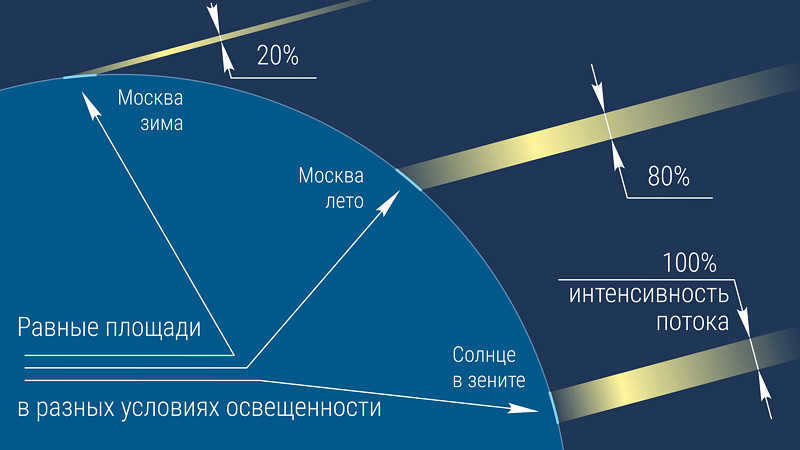
During the winter months, the residents of the middle region of Russia receive approximately 20% of the “tropical heat” – a significantly lower amount compared to other seasons.
This discrepancy is not due to a mere 6% difference in distance. Instead, it is a result of the tilt of the Earth’s axis, which leads to over 5 times less solar heat. Additionally, the winter days are much shorter, lasting only 6 hours compared to the 17-hour days of summer, and often characterized by heavy cloud cover.
These factors contribute to the significant seasonal changes experienced in this region.
However, not all regions experience such drastic seasonal variations.
In the equatorial zone, as previously mentioned, there are no seasonal changes. In this area, the Sun rises to a high position above the horizon every day, and the length of the day is nearly equal to the night throughout the year.
Now, let’s examine the scenario from an external perspective. So far, we have assumed the varying heights of the Sun above the horizon as a constant. However, what causes this phenomenon?
Once again, let’s refer to our “tellurium” and carefully analyze each of its seasonal positions.
Today, we are observing the autumnal equinox. From this perspective, we can observe that the Earth’s poles – both north and south – are equally illuminated by the sunlight, despite the tilt of the Earth’s axis. The light stream from the Sun touches both poles as it passes by, ensuring that both the northern and southern hemispheres receive equal illumination.
In three months’ time, our planet will reach the winter solstice, where the northern hemisphere will be tilted away from the Sun. This means that the Sun’s rays will only touch the northern territories of Russia briefly, resulting in a lack of warmth. However, the image also showcases the sunlit Antarctica, where the penguins are currently enjoying the height of the Antarctic summer. Interestingly, the coastline of Antarctica lies in the same latitudes as the middle belt of Russia, albeit in the southern hemisphere. It’s possible that the penguins would feel quite comfortable in our climate!
After three months, the length of the day once again surpasses the length of the night, marking the arrival of the spring equinox. This time, it is evident that both the northern and southern hemispheres are receiving approximately equal amounts of sunlight. The Sun shines on both the Arctic Ocean and Antarctica simultaneously. However, while Antarctica experiences polar night, the Arctic Ocean is experiencing polar day.
Now we have arrived at summer – the Earth has reached a position in its orbit where the tilt of its rotational axis leads to the northern hemisphere being bathed in intense sunlight. We can observe the European part of Russia directly facing the Sun, with its rays falling on the surface at a nearly perpendicular angle. This marks the day of the summer solstice, which is also considered the start of astronomical summer by astronomers.
According to the calendar, summer begins on June 1st, but the Earth’s atmosphere takes time to warm up, usually not reaching its peak until July. Unfortunately, by August, temperatures begin to cool down again. However, even in October, there are still some warm days, as winds from southern regions often make their way to our northern latitudes, bringing pleasant surprises.
In the southern hemisphere of our planet, the seasons are diametrically opposite. As autumn arrives for us, spring emerges on the other side of the equator. Meanwhile, while we battle snowdrifts and snowstorms, Australia and Argentina bask in scorching summers.
All of this is made possible by the tilt of our planet’s rotational axis, which measures 23.5 degrees.
If this tilt were slightly less, the changes in seasons on Earth would be less pronounced, resulting in relatively consistent weather worldwide. Conversely, if life had originated and evolved to intellectual heights under these circumstances, the creatures inhabiting our planet would be vastly different from us.
But what if the tilt of the rotational axis were excessively large, akin to the planet Uranus?
Then, one of the hemispheres would experience almost half a year of intense sunlight, while the other hemisphere would be in darkness for half the year. This would result in an extreme climate, with a stark temperature contrast – scorching heat would give way to bitter cold, and powerful winds would sweep across the equator, generating massive storms on a global scale during the short off-season.
However, we must appreciate what we have. Surprisingly, the Universe has provided us with very favorable conditions. While we may feel down during the autumn due to prolonged rains, our sadness is easily offset by the beauty of snow glistening in the sunlight, the cheerful chirping of birds in spring, and the warmth and fragrance of nature in summer.

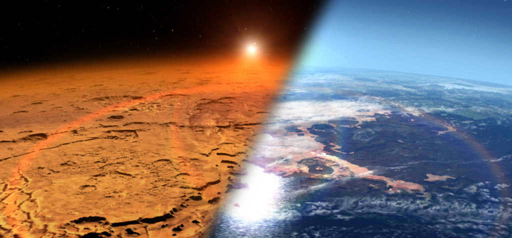
When we observe Mars through telescopes and study it using automated stations, we can observe numerous processes that are similar to those on Earth. One of these parallels is the changing of seasons on the red planet. By examining how this phenomenon occurs on Mars, we can gain a better understanding of the reasons behind the changing seasons on our own planet.
Now it is our responsibility to comprehend what has rendered the Martian climate nearly inhospitable. This is also significant for us because, despite the stability of space orbits and moderate solar activity, the Earth’s climate has been undergoing noticeable changes in recent years. These changes are no longer limited to just seasonal variations. It is crucial for humanity to ascertain the causes of these changes. Without this knowledge, we run the risk of eventually finding ourselves in a situation similar to that of hypothetical Martians who failed to maintain the equilibrium of their world.
Musical App
Seasons are not my muse for music. However, I have an album that captures the essence of autumn, with melodies that echo the rustling of crimson leaves. I began composing it in the autumn of 2015 but couldn’t finish it until closer to the fall of 2020.
The album is titled “AMBER 2015.” Amber, a mineral associated with autumn, symbolizes entering a state of dormancy or hibernation. During the fall, a part of earthly life goes to sleep, and those who depart to me are uncertain if they will ever awaken. This peculiar music reflects that uncertainty.
Despite these philosophical musings and melancholic autumnal moods, spring will inevitably arrive in the world.
Determining the sides of the world, the orienteer’s position in relation to known settlements, and the direction of travel to familiar objects can be accomplished through the technique of orienteering by the sun. There are instances where a compass or a navigator may not be readily available. In such situations, it is possible to ascertain the sides of the horizon with the aid of the sun.
What is orienteering
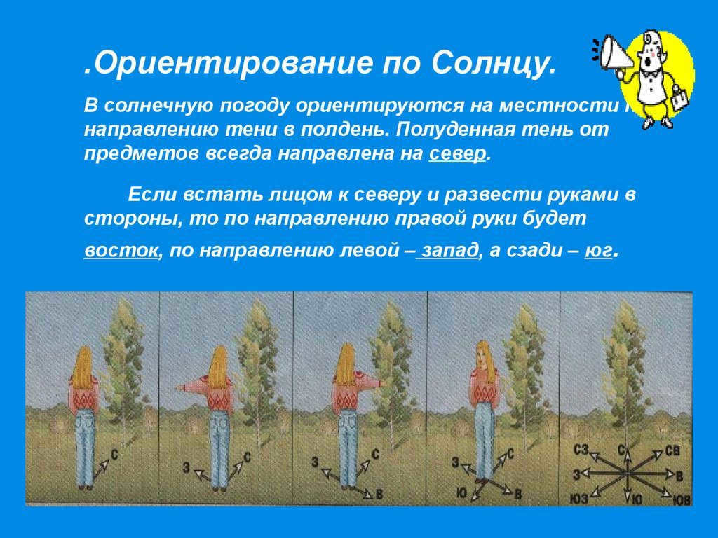
When you’re traveling or hiking in search of mushrooms, you may find yourself in various situations. It’s possible to get lost in a dense forest or even in an open steppe. Regardless of the circumstances, it’s crucial to be able to navigate and find your way back home. This requires having a proper understanding of your surroundings, including being able to identify the different sides of the horizon, determine your position in relation to nearby settlements, and choose the correct direction to reach them. The fundamentals of these skills are taught in school. In geography, there are four cardinal directions – north, west, south, and east – that are essential for orienteering.
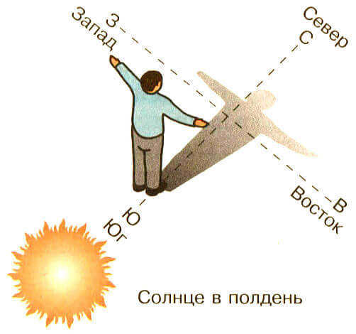
Throughout history, humanity has devised numerous techniques for determining the cardinal directions. From ancient times, people understood the fundamental concept of using the sun as a guide – the east represents sunrise, while the west signifies sunset. In ancient maps, the south was the point of reference, determined by the sun’s position at its highest point in the sky. Geography relies on four primary directions – north, west, south, and east. Over time, humanity has developed a wide array of methods for discerning the cardinal directions. Even in antiquity, individuals grasped the basic principle of orienting themselves using the sun – the east denotes the location of its ascent, and the west signifies its descent. All old maps were aligned with the south, determined by the sun’s position at its zenith.
It appears that the knowledge of how to determine the directions of east and west correctly and easily is widespread: the sun rises and sets in these parts of the horizon. However, this understanding is not entirely accurate. To accurately determine the correct direction, one must consider their location – whether they are in the Southern Hemisphere or the Northern Hemisphere – as the points where the sun rises and sets, which serve as guides, differ.
Therefore, in the North Hemisphere, the sun ascends in the east and descends in the west exclusively on March 21 and September 23, which are the dates of the spring and fall equinoxes. Following March 21, the location of sunrise moves nearer to the north, and on the summer solstice (June 21) it ascends in the northeast and sets in the northwest, as on this day the north pole is closest to the Sun. As the winter period approaches, the luminary sets nearer to the south, on the day of the winter solstice (December 22) sunrise takes place in the southeast and sunset – in the southwest. Consequently, in the South Hemisphere, sunrise and sunset are precisely the opposite in relation to the North Hemisphere. If you don’t have a mechanical clock at your disposal, you can use a natural “dial”.
Orienteering using the sun: sundial
In the southern hemisphere, the shadow will indicate the direction of the south, with the left side pointing towards the west and the right side pointing towards the east. Determining direction based on the position of the sun can be done using another method, which is more precise but requires more time. The process begins before the sun reaches its highest point in the sky: a long stick is planted into the ground, just like in the first method, and a first mark is made. A rope is then stretched from the base of the stick to the first mark, and a semicircle is drawn on the ground using this mark as the starting point. As the sun continues to rise and approach noon, the shadow cast by the stick will gradually become shorter and move away from the edge of the semicircle. The movement of the shadow will be towards the east.
Based on the Sun’s position
In certain situations, knowing the cardinal directions may not be crucial. For instance, if an individual is lost in an unfamiliar area like a forest without a map or knowledge of the emergency azimuth, the Sun can serve as a guide to move in a specific direction, preventing them from wandering aimlessly. By following a consistent path, provided there are no dense obstacles or thick vegetation, it becomes easier to reach a clearing, trail, stream, road, or railway, thus ensuring a quicker and more efficient way to find help with minimal energy expenditure.
By the way
There is a common belief that when a person is in a forest without any landmarks, they will end up walking in circles and returning to the same spot. This phenomenon is often referred to as “the leshy spins”. It is even claimed that there is a specific radius within which a person will move in a circular path. Some people explain this effect by saying that one step of a person is always shorter than the other. However, if we actually conduct an experiment where a person tries to walk in a straight line while blindfolded, we quickly realize that this information is not accurate. In a short-distance experiment, the person will veer left and right, deviating from the intended path. In long-distance experiments, the person’s trajectory will be more like zigzags.
This approach to orienteering operates based on the following procedure:
- Determine the angle (“azimuth”) of the direction of travel relative to the Sun’s position at the current moment.
- Identify a prominent feature (such as a bush, rock, or tree) that lies in the direction of travel and is as far away from the individual as possible.
- Once you have reached this landmark, use the Sun and the previously determined angle to establish the direction for further movement, where the next landmark is located.
- This is how you progress from one landmark to another. Periodically, adjustments are made to the “azimuth” by taking into account the speed and direction of the Sun’s movement in the given area.
If the person’s face is facing the Sun, whether it is in front of them, to the left, or to the right, it is practical to measure the angle relative to the Sun’s projection on the horizon. However, if the Sun is behind the person, making it difficult to directly calculate the angle from the Sun, the angle is measured from the shadow cast by the person.
This method of orientation also allows for surveying the surrounding area in various directions, decreasing the risk of getting lost, which is particularly important in a forest. To accomplish this:
- Leave a highly visible landmark at the starting point, such as a stack of sticks in a pyramid shape or a brightly colored piece of cloth tied to a tree branch.
- From this landmark, move in the chosen direction for one minute, after determining its “azimuth” beforehand.
- After a minute, the individual rotates 180 degrees and proceeds in the opposite direction along the reverse azimuth.
- Once the left reference point is reached, a new direction is selected for exploration, and the entire process is repeated.
When using this technique, it is convenient to utilize the “azimuth” determined by both the Sun and the shadow. For instance, if the Sun was positioned 15 degrees to the right of the direction of movement during the initial journey from the landmark, when returning to the landmark, one should choose a direction of movement where the shadow is also 15 degrees to the right.
This method of orientation is fairly approximate and, as mentioned earlier, is designed for emergency situations when the person is not concerned with the destination as long as it remains consistent.
It is my belief that we have successfully discovered the method of identifying the cardinal directions with the assistance of the Sun. Now, I would like to discuss the process of determining one’s coordinates using the Sun. This particular subject may not be widely known among hikers, but considering its direct relevance to orienteering, I find it essential to address.
Utilizing the Terminations of Two Shadows
This technique is founded upon the comprehension that the Sun perpetually traverses from the eastern horizon to the western horizon, thus causing shadows to shift in the opposite direction, from west to east. By demarcating two distinct locations where the gnomon’s shadow terminates, with a time difference of approximately 15-20 minutes, and subsequently joining these two marks, the resultant line segment will invariably align in a west-east orientation.
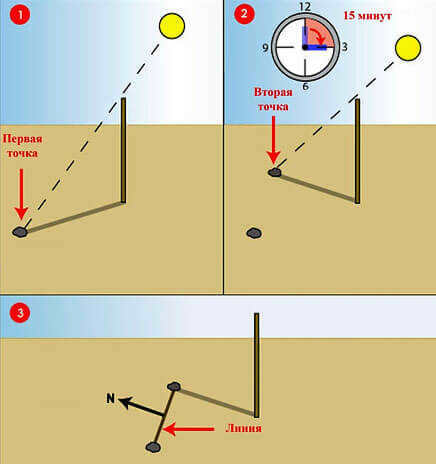
To implement this technique, there is no need to wait for the shadow to be the same length in the evening as it is in the morning – all you need is two points marked at a relatively significant distance.
This technique allows you to navigate using the Sun without relying on a clock for a brief period of time, but it may produce significant inaccuracies during periods far from the spring and fall equinoxes. If you need to use this method in the summer or winter, it is advisable to do so around midday: the closer to noon, the smaller the margin of error. This is particularly important for regions with high latitudes experiencing polar days, where using this technique at 12:00 and 24:00 will yield completely opposite readings. For example, if south was determined at noon, north would be determined at midnight, and vice versa.
Even in overcast conditions, it is still possible to navigate using the sun. This technique relies on utilizing shadows, which are still present even when direct sunlight is not. By observing these shadows, one can determine the direction of east and west. To do this, a long stick, around forty centimeters in length, should be firmly planted into the ground so that it does not produce a shadow – indicating that its top is aligned with the sun. Afterward, one must patiently wait until the stick begins to cast a shadow once more. As the shadow gradually moves, one can mark the spot where the end of the stick was pointing with pebbles.
By placing the first pebble to the west and the second pebble to the east, the shadow will gradually move in that direction. The north-south line is perpendicular to the west-east line. Even after sunset, it is still possible to determine orientation based on the position of the sun. In summer nights, the northern side of the sky becomes brighter and the southern side becomes darker due to the sun being close to the horizon. Although it may seem complicated, orienting oneself during daylight hours allows for determining the correct direction in relation to the cardinal directions, familiar landmarks, and settlements without interrupting the hike. It is important to ensure accurate calculations and consider the decreasing amount of daylight.
Natural landmarks
On a remarkable overcast day, when the sun is not visible, one can rely on other natural features found in the forest to navigate. The trees themselves can provide guidance, as they tend to grow in a direction that points towards the north and south. Lichens and mosses often grow on the northern side of tree trunks, as the southern side receives more sunlight and dries out faster, making it inhospitable for these organisms to thrive.


